Life-threatening and locally catastrophic flash and urban flooding is expected across portions of south-central Texas through early Friday, with significant river flooding and rapid rises on small streams, arroyos, and typically dry washes expected. A significant heat wave continues for the Rockies, Northern Plains, and Great Lakes into the Mid-Atlantic, peaking in intensity through midweek. Read More >
Event Summary: May 25, 2019
|
A slow, south moving cold front and an outflow boundary from morning thunderstorms over northern Missouri and Illinois combined with a hot and humid environment to produce widespread showers and thunderstorms across portions of eastern Iowa northwest Illinois and northeast Missouri during the evening and early overnight. Several thunderstorms became severe, and produced large hail and damaging winds. Several reports of hail ranging from quarter to golf ball size were reported along and south of I-80, while damaging winds around 60 MPH were reported south of Highway 34. In addition, torrential rainfall amounts of 1-4 inches were reported across southeast Iowa, west central Illinois and northeast Missouri as storms slowly moved across the area. This lead to flash flooding across many major roadways, including Highway 61 near Augusta IL and Gregory Landing MO, and County Road A near Rutledge MO.
|
|
Storm Reports
| SPC Storm Reports |
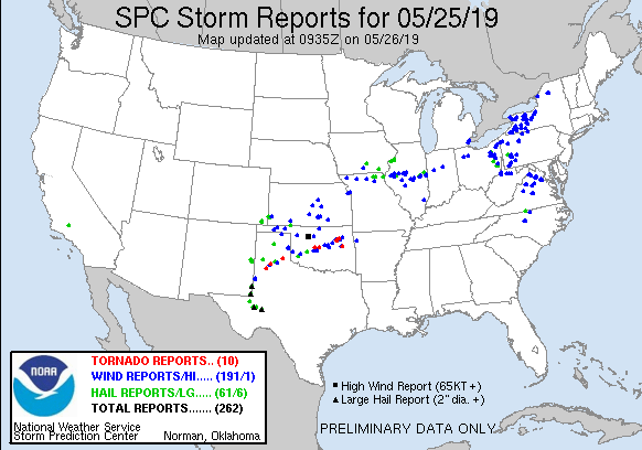 |
PRELIMINARY LOCAL STORM REPORT...SUMMARY
NATIONAL WEATHER SERVICE QUAD CITIES IA IL
513 AM CDT SUN MAY 26 2019

..TIME...   ...EVENT...      ...CITY LOCATION...     ...LAT.LON...
..DATE...   ....MAG....      ..COUNTY LOCATION..ST.. ...SOURCE....
            ..REMARKS..

0736 PM     HEAVY RAIN       1 S BIBLE GROVE         40.34N 92.30W
05/25/2019  M1.25 INCH       SCOTLAND           MO   PUBLIC

            RAINFALL IN 15 MINUTES.

0736 PM     HAIL             1 S BIBLE GROVE         40.34N 92.30W
05/25/2019  M1.75 INCH       SCOTLAND           MO   PUBLIC

            HAIL WAS NOT PERFECTLY ROUND.

0757 PM     HAIL             4 WSW BIRMINGHAM        40.86N 92.01W
05/25/2019  M1.50 INCH       VAN BUREN          IA   PUBLIC

            HEAVY RAIN AND WIND WITH THUNDERSTORM.

0849 PM     HAIL             2 NW SAINT PATRICK      40.29N 91.64W
05/25/2019  M1.00 INCH       CLARK              MO   TRAINED SPOTTER


0900 PM     FLASH FLOOD      2 E RUTLEDGE            40.32N 92.05W
05/25/2019                   SCOTLAND           MO   LAW ENFORCEMENT

            WATER OVER COUNTRY ROAD A. DELAYED ENTRY.

0952 PM     TSTM WND GST     PLYMOUTH                40.29N 90.92W
05/25/2019  M59 MPH          HANCOCK            IL   FIRE DEPT/RESCUE


0953 PM     HAIL             2 ESE MARSTON           41.31N 90.77W
05/25/2019  M1.25 INCH       MERCER             IL   TRAINED SPOTTER


1004 PM     HAIL             MOLINE QUAD-CITY AIRPOR 41.40N 90.55W
05/25/2019  M1.00 INCH       ROCK ISLAND        IL   OFFICIAL NWS OBS

            HAIL COVERING NEARLY 80% OF HIS DECK.

1005 PM     TSTM WND DMG     5 SE MACOMB             40.42N 90.61W
05/25/2019                   MCDONOUGH          IL   LAW ENFORCEMENT

            1/2 MILE OF POWER POLES BLOWN OVER BETWEEN
            MACOMB AND INDUSTRY.

1006 PM     HAIL             3 WNW OAK GROVE         41.43N 90.62W
05/25/2019  E0.25 INCH       ROCK ISLAND        IL   TRAINED SPOTTER

            BRIEF PEA SIZE HAIL AND VERY HEAVY RAIN.

1013 PM     HAIL             1 WNW MOLINE            41.49N 90.51W
05/25/2019  M1.00 INCH       ROCK ISLAND        IL   BROADCAST MEDIA

            HAIL LASTED 3 MINUTES.

1015 PM     HAIL             1 NNE SUNNY HILL        41.41N 90.43W
05/25/2019  E1.00 INCH       HENRY              IL   TRAINED SPOTTER


1018 PM     HAIL             2 ENE MOLINE            41.50N 90.46W
05/25/2019  E0.70 INCH       ROCK ISLAND        IL   TRAINED SPOTTER


1040 PM     FLASH FLOOD      CARTHAGE                40.41N 91.14W
05/25/2019                   HANCOCK            IL   LAW ENFORCEMENT

            WATER ON HIGHWAY IN TOWN.

1040 PM     FLASH FLOOD      3 SW GREGORY LANDING    40.25N 91.54W
05/25/2019                   CLARK              MO   LAW ENFORCEMENT

            WATER OVER HIGHWAY 61 ALONG THE CLARK AND
            LEWIS COUNTY LINE.

1055 PM     FLASH FLOOD      2 NNE AUGUSTA           40.26N 90.93W
05/25/2019                   HANCOCK            IL   LAW ENFORCEMENT

            WATER OVER HIGHWAY 61 BETWEEN AUGUSTA AND
            PLYMOUTH.

1246 AM     HEAVY RAIN       PLYMOUTH                40.29N 90.92W
05/26/2019  M3.40 INCH       HANCOCK            IL   PUBLIC

            REPORT VIA WGEM.
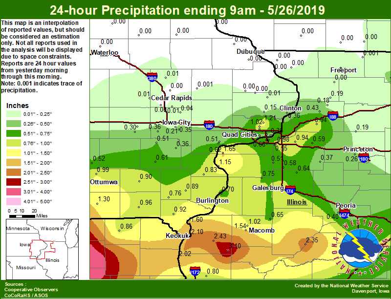
Area Rainfall Amounts
|
24-hr Local Rainfall Map
|
24-hr Regional Rainfall Map
|
24 hour precipitation reports (in Inches),
for eastern Iowa, northwest and west central Illinois,
and northeast Missouri. Reported between Midnight and 9 AM,
Sunday May 26, 2019.
....IOWA....
Rathbun Reservoir 2 N            2.20
Keokuk LD19                      2.10
Bloomfield 1 NW                  1.30
Park View 0.2 WSW                1.21
Allerton 2 S                     1.10
Eldridge 0.7 SSW                 1.02
Pella 4 N                        1.01
Ottumwa ASOS 6 NNW               0.99
Keosauqua                        0.96
Burlington 0.8 SSE               0.93
Donnellson                       0.92
Fairfield                        0.90
New London 1.5 SW                0.89
Burlington Arpt 2 SW             0.85
Morning Sun 1.7 E                0.83
Beaconsfield 1 NNE               0.79
Albia 3 NNE                      0.79
Salem 1S                         0.76
Davenport Arpt 5 N               0.74
Washington 5.8 SW                0.61
Oskaloosa AWOS 9 ESE             0.52
Muscatine 2.6 NNE                0.51
Wellman 4.0 E                    0.51
Bettendorf 1.6 WSW               0.48
Davenport 0.9 SSW                0.45
Pella AWOS 2 WSW                 0.43
Davenport 0.9 WNW                0.41
Bettendorf 2.2 SE                0.39
Camanche 1.2 W                   0.36
Riverdale 0.5 N                  0.36
Kalona 7.3 NNW                   0.36
Ainsworth 7.4 N                  0.36
Iowa City                        0.35
Muscatine 2N                     0.32
Parnell 0.1 SSW                  0.30
Newton 1 NE                      0.26
Iowa City Arpt                   0.21
Williamsburg                     0.16
De Witt                          0.15
Grinnell AWOS 2 SSW              0.14
Solon 0.3 ESE                    0.04
Central City 6.7 W               0.01
Ely 0.5 SE                       0.01
Charlotte 1.9 WNW                0.01
Fairfax 4.0 NW                   0.01
Anamosa 3 SSW                    0.00
Dubuque Arpt 7 SW                0.00
Maquoketa 4 W                    0.00
Bellevue LD12                    0.00
Mason City ASOS 6 W              0.00
Dubuque LD11                     0.00
Mason City 1 NNE                 0.00
Cedar Rapids Arpt 5 SW           0.00
Rickardsville 0.2 W              0.00
Marion 1.7 NNW                   0.00
NWS Johnston* 5 NNW              0.00
Oelwein AWOS                     0.00
Asbury 0.4 SW                    0.00
Boone 1 SSW                      0.00
Marshalltown 1 NW                0.00
Toledo 3 N                       0.00
Fayette 1 NW                     0.00
Strawberry Point                 0.00
Hampton 1 N                      0.00
Waterloo ASOS 5 NW               0.00
Guttenberg Dam 10                0.00
Marshalltown ASOS 4 N            0.00
Tripoli 0 N                      0.00
Delmar 2.3 NW                    0.00
....ILLINOIS....
Augusta                          3.10
Bentley                          2.43
Havana                           2.35
Illinois City 6.7 SW             1.65
Nauvoo 0.7 SSE                   1.60
Colchester 3.5 NE                1.54
New Boston LD17                  1.15
Macomb 3.8 NW                    1.02
Coal Valley 2.6 E                0.98
Prophetstown 0.2 SW              0.94
Geneseo 2.0 NW                   0.94
Galesburg                        0.86
Bloomington Airport              0.83
Lincoln NWS                      0.81
Quincy ASOS                      0.80
Alexis 1 SW                      0.75
Galesburg Arpt 3 SW              0.75
Quincy Dam 21                    0.74
Gladstone LD18                   0.70
Moline 1.0 WNW                   0.68
Prairie City 2S                  0.65
Altona                           0.64
Quad City Arpt 3 S               0.62
Ill. City LD16 3 WNW             0.62
Atkinson 2.6 NNE                 0.59
Woodhull 0.3 ESE                 0.58
Jacksonville AWOS                0.56
Moline 0.7 NNE                   0.55
Coal Valley 1.9 SE               0.55
New Windsor 2.0 N                0.51
Ogden                            0.43
Morrison 3.2 E                   0.43
Peoria ASOS                      0.40
Kewanee 1 E                      0.37
Rockford ASOS                    0.34
Minonk                           0.32
Paw Paw 1 E                      0.27
Tiskilwa 2.1 N                   0.26
Princeton 1.1 SE                 0.25
Princeton                        0.25
St Anne                          0.25
Milledgeville 0.6 NW             0.19
Romeoville                       0.19
Walnut 5.3 ENE                   0.19
Coleta 1.4 SSW                   0.18
Decatur Airport                  0.18
Tuscola                          0.16
Streator 3 SE                    0.13
Mundelein                        0.11
Windsor                          0.10
Ottawa 4 SW                      0.10
Roscoe 2SE                       0.09
Freeport 2.9 WSW                 0.05
Freeport                         0.04
Steward                          0.04
Joliet                           0.03
Freeport 2.0 NW                  0.02
Rochelle AWOS                    0.01
Davis 0.5 N                      0.00
Galena                           0.00
Shannon 0.2 S                    0.00
Elizabeth                        0.00
Freeport 1.7 NW                  0.00
....MISSOURI....
Kirksville ASOS                  4.02
Canton LD20                      2.02
Memphis                          0.86
Chillicothe 2 NW                 0.46
Columbia                         0.00
....WISCONSIN....
Beloit-College                   0.19
Whitewater                       0.04
Allenton-WWTP .6 NW              0.03
Darlington                       0.00
Brodhead 1 SW                    0.00
Watertown-AWOS                   0.00
Madison-ASOS                     0.00
Prairie du Chien AWOS            0.00
Viroqua                          0.00
Steuben 4SE 3 NE                 0.00
Monroe 1 W                       0.00
La Crosse WFO                    0.00
....MINNESOTA....
Theilman 1SSW                    0.00
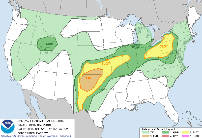
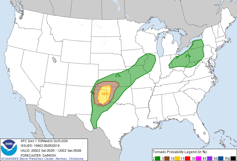
Environmental Analysis / Other Information
SPC Convective Outlooks
 |
 |
 |
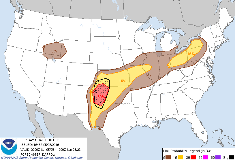 |
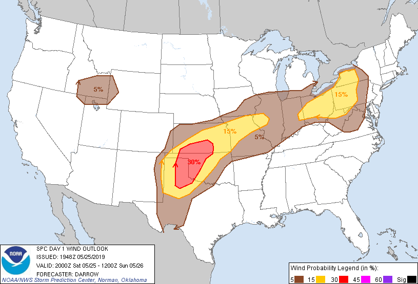
| SPC Day 1 Outlook (2000z) | SPC Day 1 Tornado Outlook (2000z) | SPC Day 1 Wind Outlook (2000z) | SPC Day 1 Hail Outlook (2000z) |
Local Sounding Analysis
 |
 |
|
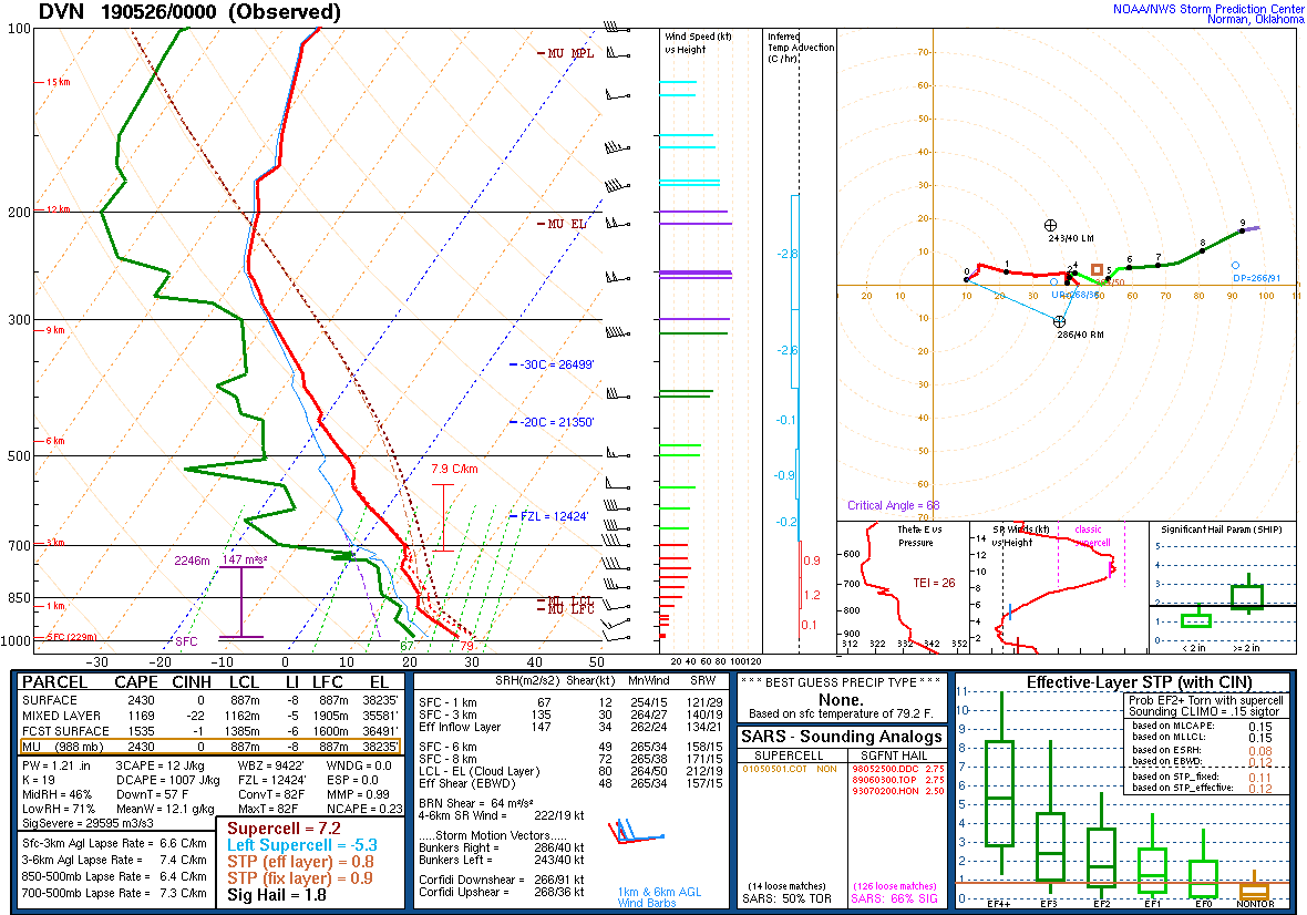
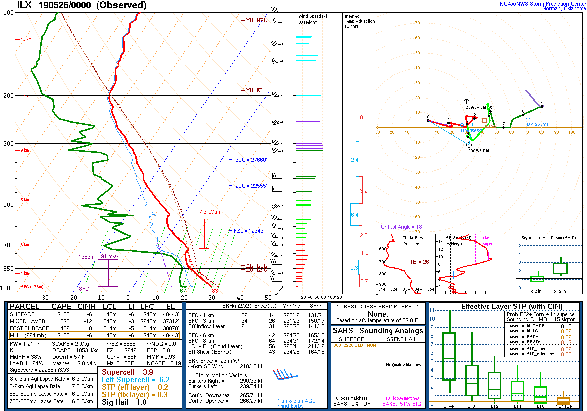
| DVN Sounding 5/26/19 00z | ILX Sounding 5/26/19 00z |
SPC Watches Issued For Our Area
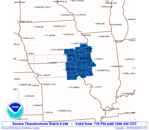 |
| SPC Severe Thunderstorm Watch #246 (see link for more details) |
SPC Mesoscale Discussions Issued For Our Area
 |
 |
|
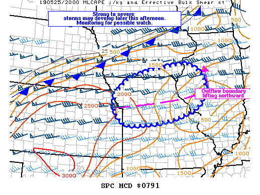
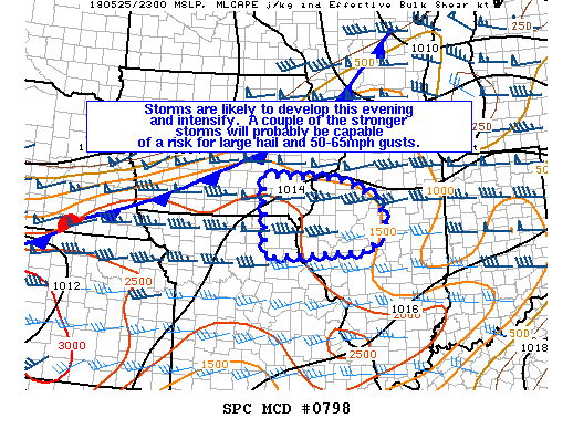
| SPC Mesoscale Discussion #791 (see link for more details) | SPC Mesoscale Discussion #798 (see link for more details) |
SPC - Storm Prediction Center
 |
Media use of NWS Web News Stories is encouraged! Please acknowledge the NWS as the source of any news information accessed from this site. |
|


.gif)