Dangerous heat will expand from the Gulf Coast into the Southern Plains and Desert Southwest through week's end. Additional extreme heat impacting the Pacific Northwest will shift to the northern Plains by the weekend. Tropical Storm Bertha is expected to continue to impact portions of the northern Gulf Coast from the western Florida Panhandle to southeastern Louisiana through tonight. Read More >
Overview
|
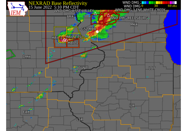
Scattered showers and thunderstorms tracked east along and ahead of a cold front that pushed through eastern IA, northwest IL, and northeast MO during the late afternoon and evening. Some of the storms produced large hail, gusty winds, and heavy rain and the strongest storms brought large hail to portions of Buchanan county and damaging winds in Muscatine county. |
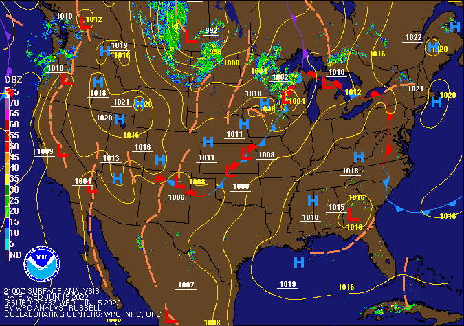 WPC Surface Analysis 21z 06/15/22 |
Storm Reports
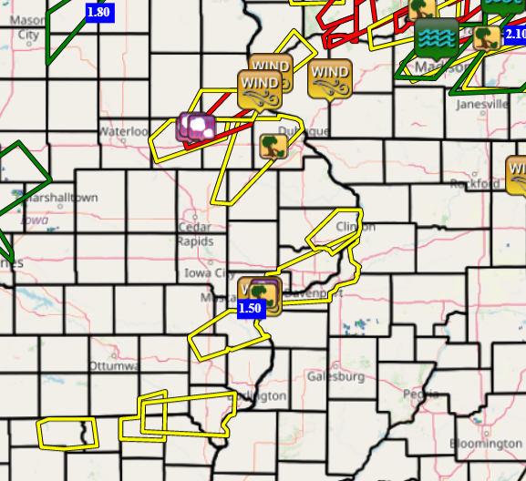
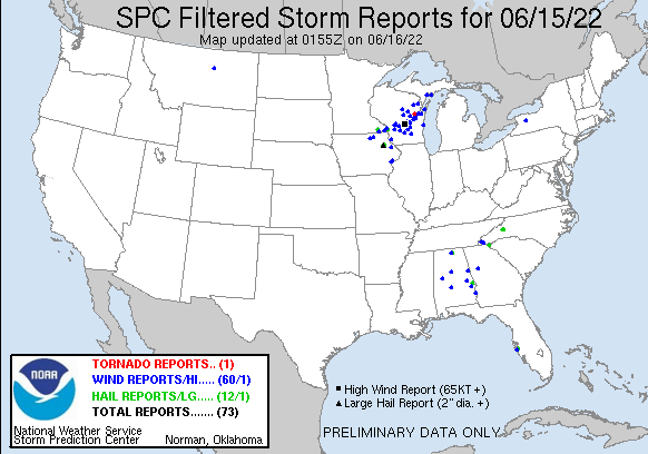
| Interactive Storm Report Map (IEM) | SPC Storm Reports |
 |
 |
PRELIMINARY LOCAL STORM REPORT...SUMMARY
NATIONAL WEATHER SERVICE QUAD CITIES IA IL
928 PM CDT WED JUN 15 2022

..TIME...   ...EVENT...      ...CITY LOCATION...     ...LAT.LON...
..DATE...   ....MAG....      ..COUNTY LOCATION..ST.. ...SOURCE....
            ..REMARKS..

0435 PM     TSTM WND DMG     1 WNW EPWORTH           42.45N 90.95W
06/15/2022                   DUBUQUE            IA   PUBLIC

            BRANCHES OF UNKNOWN SIZE DOWN WEST OF
            EPWORTH.

0505 PM     HAIL             4 S AURORA              42.57N 91.72W
06/15/2022  E1.00 INCH       BUCHANAN           IA   PUBLIC

            TIME ESTIMATED FROM RADAR, REPORT FROM
            MPING: QUARTER (1.00 IN.).

0509 PM     HAIL             2 W LAMONT              42.60N 91.68W
06/15/2022  E2.75 INCH       BUCHANAN           IA   FIRE DEPT/RESCUE

            RELAYED FROM COUNTY SHERIFF OFFICE, TIME
            ESTIMATED FROM RADAR.

0513 PM     HAIL             2 SE LAMONT             42.58N 91.61W
06/15/2022  M1.00 INCH       DELAWARE           IA   EMERGENCY MNGR

            STORMS MOVING AT A GOOD CLIP - WIND 35-40
            MPH.

0708 PM     TSTM WND DMG     3 NE MUSCATINE          41.46N 91.03W
06/15/2022                   MUSCATINE          IA   PUBLIC

            REPORT FROM MPING: 3-INCH TREE LIMBS BROKEN;
            POWER POLES BROKEN.

0708 PM     TSTM WND GST     MUSCATINE               41.42N 91.07W
06/15/2022  M68 MPH          MUSCATINE          IA   PUBLIC


0709 PM     HAIL             3 NE MUSCATINE          41.46N 91.03W
06/15/2022  E0.50 INCH       MUSCATINE          IA   PUBLIC

            REPORT FROM MPING: HALF-INCH (0.50 IN.).

0713 PM     TSTM WND DMG     1 NE MUSCATINE          41.43N 91.05W
06/15/2022                   MUSCATINE          IA   FIRE DEPT/RESCUE

            RELAYED A REPORT FROM FIRE DEPARTMENT OF
            TREE DOWN AND TRANSFORMER ON FIRE AT THIS
            LOCATION.

0723 PM     HEAVY RAIN       1 SSW MUSCATINE MUNICIP 41.35N 91.16W
06/15/2022  M1.50 INCH       MUSCATINE          IA   TRAINED SPOTTER

            RAIN FELL IN LESS THAN 30 MIN.
1022 PM     TSTM WND DMG     2 SSE TIPTON            41.74N 91.11W
06/15/2022                   CEDAR              IA   EMERGENCY MNGR

            EM REPORTED A TREE DOWN ON PRIVATE PROPERTY.
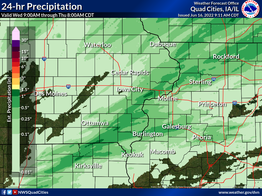
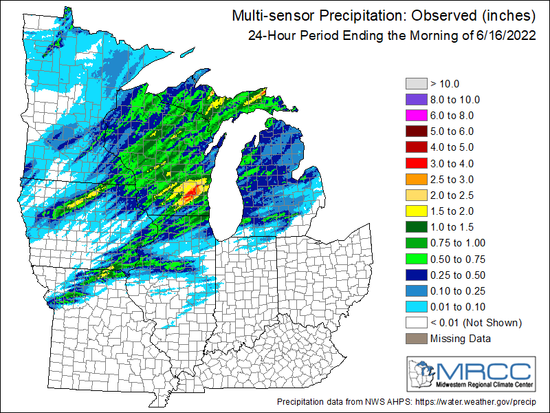
Rain Reports
Rainfall Reports (more updates Thursday)
| Local Rainfall Analysis | Regional Rainfall Analysis |
 |
 |
....IOWA....
Burlington Arpt                  1.64
Muscatine 2.1 N                  1.59
Burlington 2S                    1.57
Muscatine 1.4 N                  1.30
Muscatine 2N                     1.17
West Liberty 0.7 NNW             1.05
Mason City ASOS 6 W              1.04
Mt Pleasant 1 SSW                1.00
Davenport 2.9 W                  0.85
West Point 7.5 NW                0.77
Ainsworth 7.4 N                  0.77
Morning Sun 1.7 E                0.72
Wapello 0.2 S                    0.68
Keosauqua                        0.61
Maquoketa                        0.61
Washington                       0.60
Wapello 5.4 SE                   0.56
Nichols 3.2 SSW                  0.54
Eldridge 0.6 S                   0.54
Guttenberg Dam 10                0.46
Strawberry Point                 0.46
Wapello 4.7 N                    0.45
Lowden                           0.45
Washington 5.8 SW                0.44
Davenport 0.9 WNW                0.42
Davenport Arpt                   0.38
New London 1.5 SW                0.37
Bettendorf 1.6 W                 0.36
Salem 1S                         0.36
Salem 3.1 ESE                    0.33
Le Claire 1.8 NNE                0.33
Fayette 1 NW                     0.32
Tipton 0.7 N                     0.29
Independence 0.9 WNW             0.26
Ottumwa ASOS 6 NNW               0.22
Burlington 6.5 SSW               0.18
Waukon 3N                        0.18
Camanche 1.2 W                   0.15
Le Claire LD14                   0.14
Charlotte 1.9 WNW                0.13
Hampton 1 N                      0.10
Fort Madison 0.9 NE              0.07
Marengo                          0.07
Marshalltown ASOS 4 N            0.07
Cedar Rapids Arpt                0.05
Oelwein AWOS                     0.05
Asbury 0.4 SW                    0.04
Hopkinton 5.4 WSW                0.04
Waterloo ASOS 5 NW               0.04
Oskaloosa 1 NNW                  0.03
Manchester                       0.03
Marengo 2.6 SSW                  0.02
Center Junction 2.6 W            0.02
Peosta 2.9 E                     0.02
Williamsburg                     0.02
Elkader 6SSW                     0.02
Monticello 1 E                   0.02
Keokuk LD19                      0.02
Marshalltown 1 NW                0.02
Iowa City                        0.02
Grinnell AWOS 2 SSW              0.01
Anamosa 3 SSW                    0.01
Solon 0.3 ESE                    0.00
Central City 6.7 W               0.00
Mount Auburn 2.2 NNW             0.00
Toledo 3 N                       0.00
Boone 1 SSW                      0.00
Iowa City Arpt                   0.00
NWS Johnston* 5 NNW              0.00
Wellman 4.0 E                    0.00
North Liberty 0.7 SSW            0.00
Marengo 3.6 N                    0.00
Parnell 0.1 SSW                  0.00
Ely 0.5 SE                       0.00
Marion 1.7 NNW                   0.00
Fairfax 4.0 NW                   0.00
Oskaloosa AWOS 9 ESE             0.00
Rathbun Reservoir 2 N            0.00
Perry 0 W                        0.00
Newton 1 NE                      0.00
Dubuque LD11                     0.00
Pella 4 N                        0.00
Pella AWOS 2 WSW                 0.00
Ames US 30 2 SSE                 0.00
Dubuque Arpt                     0.00
....ILLINOIS....
Stockton 3.4 NNE                 0.93
Galesburg                        0.86
Mount Carroll 6.8 NNW            0.76
Hanover 0.2 NW                   0.75
Fulton LD13                      0.70
Peoria Arpt                      0.66
Gladstone LD18                   0.65
New Boston LD17                  0.60
Mount Carroll                    0.58
Elizabeth                        0.56
Mundelein                        0.56
Ill. City LD16 3 WNW             0.50
Rochelle Arpt                    0.50
Stronghurst 0.4 SSW              0.45
Aledo                            0.38
Freeport 1.7 NW                  0.37
Rockford Arpt                    0.34
Winslow 4.3 ESE                  0.33
Morrison 3.2 E                   0.32
Freeport                         0.31
Altona                           0.31
Ridott 0.1 NE                    0.28
Lanark 5.3 N                     0.27
Freeport 2.9 WSW                 0.25
Woodhull 0.3 ESE                 0.20
Davis 0.5 N                      0.16
Alexis 1 SW                      0.13
Macomb                           0.13
New Windsor 2.0 N                0.11
Bloomington Airport              0.11
Galva 2.7 NE                     0.10
Coal Valley 1.9 SE               0.08
Prairie City 2S                  0.08
Romeoville                       0.07
Mendota 2 SE                     0.05
Colchester 3.5 NE                0.04
Geneseo 2.0 NW                   0.04
Dallas City 3.0 SSE              0.03
Tuscola                          0.03
Augusta                          0.03
Joliet Arpt                      0.03
Walnut 5.3 ENE                   0.02
Ottawa 4 SW                      0.02
Streator 3 SE                    0.02
Quad City Arpt                   0.02
Bentley                          0.01
La Harpe                         0.00
Windsor                          0.00
Jacksonville 2E                  0.00
Princeton 1.1 SE                 0.00
Atkinson 2.6 NNE                 0.00
Jacksonville Arpt                0.00
Princeton                        0.00
St Anne                          0.00
Decatur Airport                  0.00
Ogden                            0.00
Lincoln NWS                      0.00
Quincy Arpt                      0.00
....MISSOURI....
Kahoka 0.6 S                     0.47
Memphis                          0.44
Chillicothe Arpt                 0.21
Kirksville Arpt                  0.00
Columbia Arpt                    0.00
....WISCONSIN....
Madison Arpt                     1.37
Viroqua                          0.81
Brodhead 1 SW                    0.72
La Crosse WFO                    0.68
Sullivan-NWS 2 SE                0.66
Monroe 1 W                       0.52
Whitewater                       0.40
Steuben 4SE 3 NE                 0.31
Prairie du Chien AWOS            0.30
Darlington                       0.20
Beloit-College                   0.08
....MINNESOTA....
Theilman 1SSW                    0.37
Environment
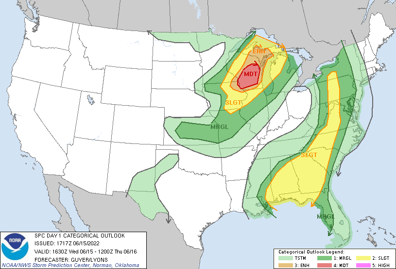
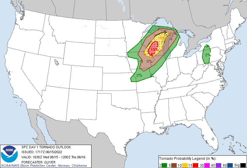
SPC EVENT REVIEW PAGE: 06/15/2022
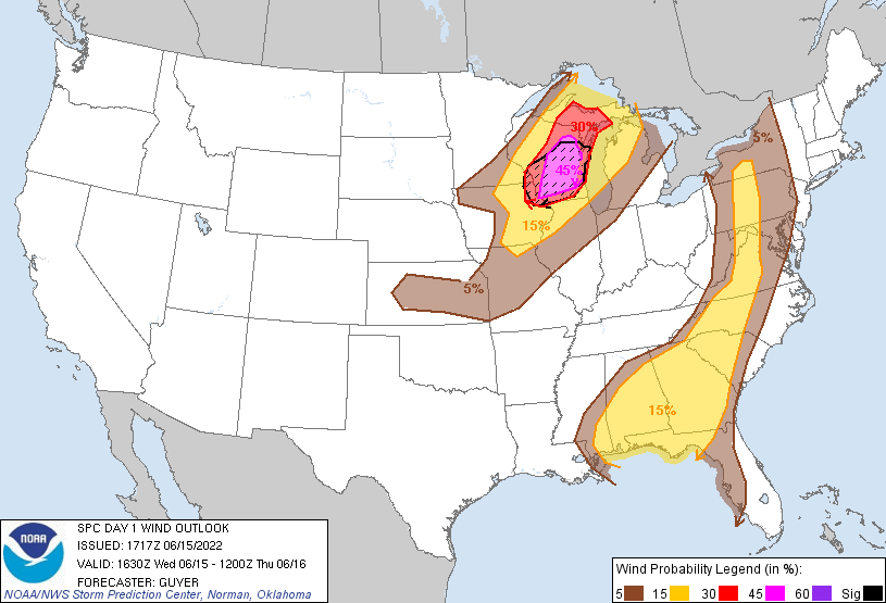
SPC Categorical/Tornado/Hail/Wind Outlooks
 |
 |
 |
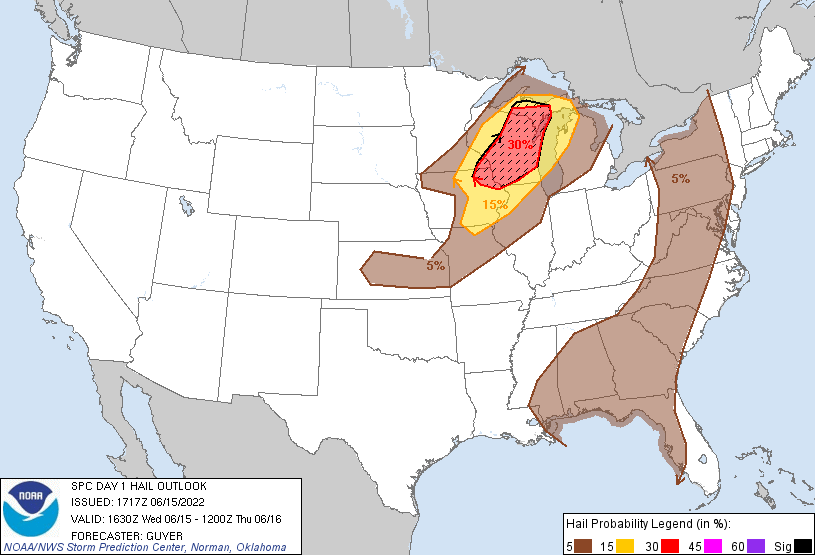 |
| SPC Categorical Outlook | Tornado Outlook | Wind Outlook | Hail Outlook |
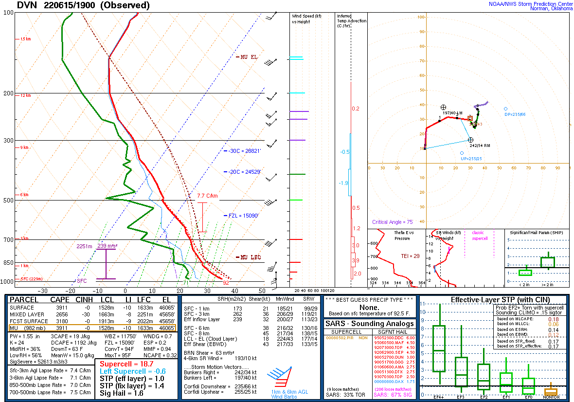
DVN Observed Sounding Analysis
 |
 |
| 200 PM DAVENPORT, IA SOUNDING | 700 PM DAVENPORT, IA SOUNDING |
SPC Mesoscale Discussions
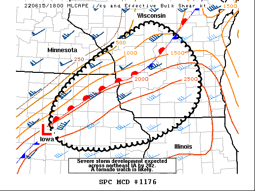  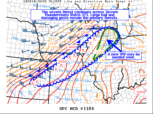 |
| MCD 176, 180, and 184 - Visit SPC MCD Archive |
 |
Media use of NWS Web News Stories is encouraged! Please acknowledge the NWS as the source of any news information accessed from this site. |
|