Widespread life-threatening flash and urban flooding continues in south-central Texas, with considerable flooding impacts possible across central Texas. Wildfire smoke is impacting air quality across much of the Great Lakes region into southern New England and the Mid-Atlantic. Monsoonal thunderstorms may produce isolated to scattered flash flooding across the Southwest into the Great Basin. Read More >
Overview
|
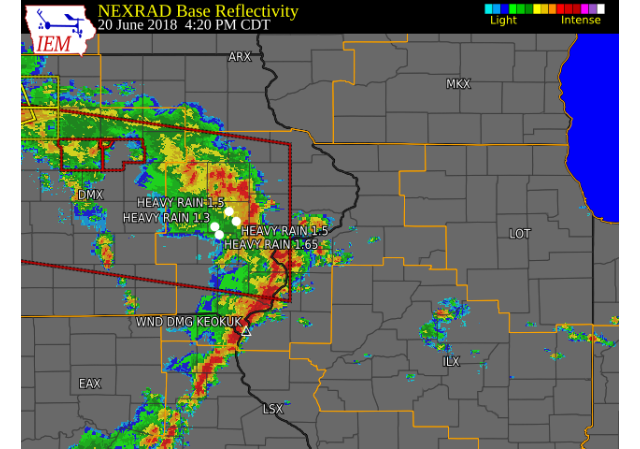
Scattered showers and thunderstorms developed and tracked across the region Wednesday afternoon and evening, as an area of low pressure moved over Iowa. Numerous storms brought torrential rain, lightning, damaging winds, and flash flooding. Rainfall totals over 2 inches was common and all falling within 6 hours. Street flooding and excessive water was reported in the Quad Cities with several vehicles stranded on roads.
|
 12-hr Radar Rainfall Estimates |
Tornado:
|
Tornado - 1 ESE Delta, IA to 2 NNW Sigourney, IA
Track Map 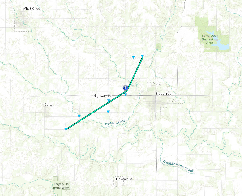 
|
||||||||||||||||
The Enhanced Fujita (EF) Scale classifies tornadoes into the following categories:
| EF0 Weak 65-85 mph |
EF1 Moderate 86-110 mph |
EF2 Significant 111-135 mph |
EF3 Severe 136-165 mph |
EF4 Extreme 166-200 mph |
EF5 Catastrophic 200+ mph |
 |
|||||
Storm Reports
| Interactive Storm Map | SPC Storm Reports |
 |
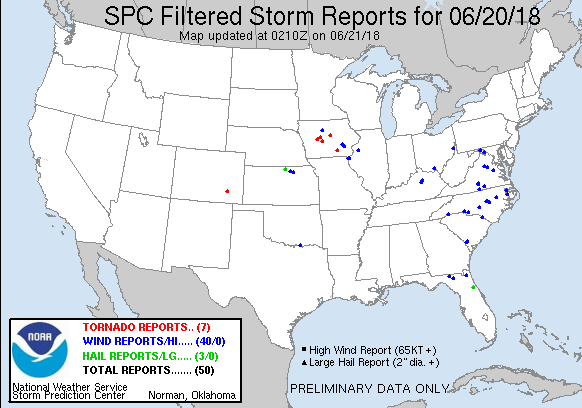 |
PRELIMINARY LOCAL STORM REPORT...SUMMARY
NATIONAL WEATHER SERVICE QUAD CITIES IA IL
850 PM CDT WED JUN 20 2018

..TIME...   ...EVENT...      ...CITY LOCATION...     ...LAT.LON...
..DATE...   ....MAG....      ..COUNTY LOCATION..ST.. ...SOURCE....
            ..REMARKS..

0326 PM     TSTM WND DMG     PARNELL                 41.58N 92.00W
06/20/2018                   IOWA               IA   TRAINED SPOTTER

            TREE BRANCHES DOWN, LARGEST 3" DIAMETER.
            TIME ESTIMATED BY RADAR.

0327 PM     TSTM WND DMG     1 ESE WEST CHESTER      41.34N 91.81W
06/20/2018                   WASHINGTON         IA   BROADCAST MEDIA

            POWER POLES SNAPPED AND CROP DAMAGE
            REPORTED, REPLAYED BY KCRG.

0333 PM     TSTM WND DMG     1 SE WASHINGTON         41.29N 91.69W
06/20/2018                   WASHINGTON         IA   PUBLIC

            BRANCHES OF LARGE TREES SNAPPED.

0343 PM     TSTM WND GST     IOWA CITY ARPT          41.64N 91.55W
06/20/2018  M46 MPH          JOHNSON            IA   ASOS

            ASOS STATION IOW, IOWA CITY ARPT.

0353 PM     HEAVY RAIN       KALONA                  41.49N 91.70W
06/20/2018  M1.00 INCH       WASHINGTON         IA   TRAINED SPOTTER

            FELL IN 25 MINUTES.

0400 PM     HEAVY RAIN       PARNELL                 41.58N 92.01W
06/20/2018  M1.03 INCH       IOWA               IA   TRAINED SPOTTER

            30 MINUTE RAINFALL.

0410 PM     HEAVY RAIN       1 ENE NORTH LIBERTY     41.75N 91.59W
06/20/2018  M1.50 INCH       JOHNSON            IA   TRAINED SPOTTER

            RAIN FELL IN PAST 20 MIN.

0415 PM     HEAVY RAIN       2 SE IOWA CITY          41.64N 91.51W
06/20/2018  E1.50 INCH       JOHNSON            IA   TRAINED SPOTTER

            30 MINUTE RAINFALL. MINOR STREET FLOODING
            ALONG CURBS TO 3 FEET INTO STREETS.

0420 PM     HEAVY RAIN       KALONA                  41.49N 91.70W
06/20/2018  M1.65 INCH       WASHINGTON         IA   PUBLIC

            REPORT FROM SOCIAL MEDIA. RAIN FALL IN HALF
            AN HOUR.

0425 PM     TSTM WND DMG     KEOKUK                  40.42N 91.40W
06/20/2018                   LEE                IA   TRAINED SPOTTER

            DELAYED REPORT OF A TREE DOWN IN NORTHERN
            KEOKUK. TIME ESTIMATED BASED ON RADAR.

0425 PM     HEAVY RAIN       1 NW WILLIAMSTOWN       41.58N 91.75W
06/20/2018  E1.30 INCH       JOHNSON            IA   TRAINED SPOTTER

            45 MINUTE RAINFALL.

0428 PM     FUNNEL CLOUD     SPRINGVILLE             42.06N 91.44W
06/20/2018                   LINN               IA   EMERGENCY MNGR


0446 PM     TSTM WND DMG     1 SSW MOOAR             40.44N 91.45W
06/20/2018                   LEE                IA   TRAINED SPOTTER

            LIGHT POLE DOWN ALONG WITH SEVERAL 2 INCH
            DIAMETER BRANCHES.

0512 PM     HEAVY RAIN       BURLINGTON REGIONAL AIR 40.78N 91.13W
06/20/2018  M2.24 INCH       DES MOINES         IA   ASOS

            TOTAL RAINFALL SINCE 5PM. OVER 2 INCHES FELL
            BETWEEN 4 AND 5 PM.

0515 PM     HEAVY RAIN       MOUNT PLEASANT          40.96N 91.55W
06/20/2018  M2.12 INCH       HENRY              IA   BROADCAST MEDIA

            PUBLIC REPORT RELAYED FROM WQAD. RAINFALL
            BETWEEN 2:30 PM AND 4:30 PM.

0515 PM     HEAVY RAIN       2 NNW DAVENPORT         41.58N 90.61W
06/20/2018  U0.00 INCH       SCOTT              IA   NWS EMPLOYEE

            VERY HEAVY RAIN FALLING CURRENTLY, STALLED
            CAR IN STREET WITH WATER FLOWING OVER ROAD
            NEAR PINE ST.

0533 PM     FLASH FLOOD      1 SSE DAVENPORT         41.54N 90.59W
06/20/2018                   SCOTT              IA   TRAINED SPOTTER

            WATER OVER STREETS TOWARDS HOSPITAL NEAR
            MARQUETTE AND LOCUST STREETS. DUCK CREEK
            ALSO RISING VERY FAST AND ABOUT 1 FT NEAR
            BANK FULL.

0540 PM     HAIL             3 WSW BETTENDORF        41.54N 90.53W
06/20/2018  M0.25 INCH       SCOTT              IA   TRAINED SPOTTER


0544 PM     HEAVY RAIN       LOWDEN                  41.86N 90.92W
06/20/2018  E1.25 INCH       CEDAR              IA   CO-OP OBSERVER

            RAIN FELL IN PAST 35 MIN.

0545 PM     HEAVY RAIN       HIAWATHA                42.05N 91.68W
06/20/2018  E1.50 INCH       LINN               IA   TRAINED SPOTTER

            TOTAL SO FAR.

0548 PM     FLASH FLOOD      1 WNW DAVENPORT         41.56N 90.62W
06/20/2018                   SCOTT              IA   PUBLIC

            CARS STRANDED ON KIMBERLY RD WEST OF
            DIVISION TOWARDS WAL-MART, REPORT VIA KWQC
            FACEBOOK.

0550 PM     FLASH FLOOD      1 NE DAVENPORT          41.56N 90.60W
06/20/2018                   SCOTT              IA   PUBLIC

            CAR STRANDED WITH WATER MORE THAN HALFWAY UP
            ITS SIDE. REPORT WITH PHOTO VIA KWQC
            FACEBOOK.

0554 PM     FLASH FLOOD      2 ESE DAVENPORT         41.54N 90.57W
06/20/2018                   SCOTT              IA   PUBLIC

            6+ INCHES FAST MOVING WATER NEAR
            INTERSECTION OF PERSHING AND DOVER. REPORT
            VIA FACEBOOK.

0615 PM     HEAVY RAIN       DAVENPORT MUNICIPALITY  41.62N 90.58W
06/20/2018  M2.93 INCH       SCOTT              IA   ASOS

            TOTAL RAINFALL AS OF 615PM. RAIN STILL
            ONGOING.

0633 PM     FLASH FLOOD      BETTENDORF              41.56N 90.48W
06/20/2018                   SCOTT              IA   PUBLIC

            CAR STRANDED AT THE INTERSECTION OF
            TANGLEFOOT AND DEVILS GLEN RD IN BETTENDORF.
            REPORT W/ PHOTO VIA KWQC FACEBOOK PAGE.

0653 PM     HEAVY RAIN       1 S DAVENPORT           41.55N 90.60W
06/20/2018  E4.00 INCH       SCOTT              IA   TRAINED SPOTTER


0700 PM     HEAVY RAIN       1 E GREEN RIVER         41.47N 90.32W
06/20/2018  M1.00 INCH       HENRY              IL   TRAINED SPOTTER

            90 MINUTE RAINFALL.

0713 PM     HEAVY RAIN       1 NE KEOKUK             40.42N 91.39W
06/20/2018  E2.10 INCH       LEE                IA   TRAINED SPOTTER


0716 PM     HEAVY RAIN       2 NE COLUSA             40.59N 91.14W
06/20/2018  E1.02 INCH       HANCOCK            IL   TRAINED SPOTTER


0802 PM     HEAVY RAIN       1 NE FORT MADISON       40.64N 91.33W
06/20/2018  E2.50 INCH       LEE                IA   TRAINED SPOTTER


0809 PM     HEAVY RAIN       1 SSW DAVENPORT         41.55N 90.61W
06/20/2018  M4.50 INCH       SCOTT              IA   TRAINED SPOTTER

            RAIN TOTAL SINCE 430 PM.

0824 PM     HEAVY RAIN       1 NW ELDRIDGE           41.64N 90.59W
06/20/2018  M2.53 INCH       SCOTT              IA   NWS EMPLOYEE

            RAINFALL IN PAST 12-HRS.
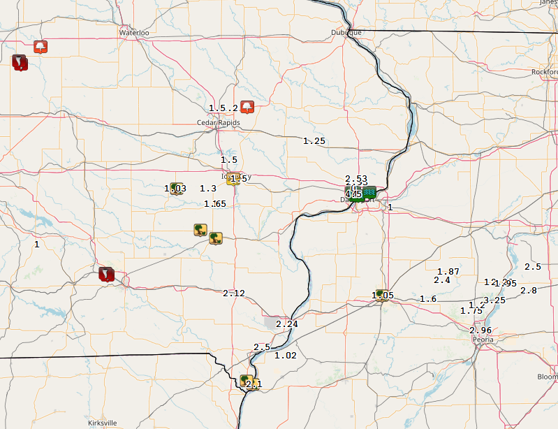
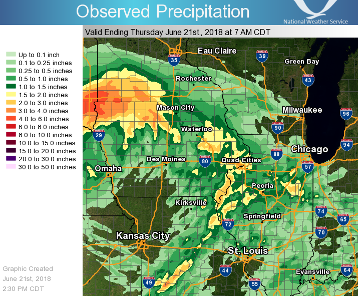
Rain Reports
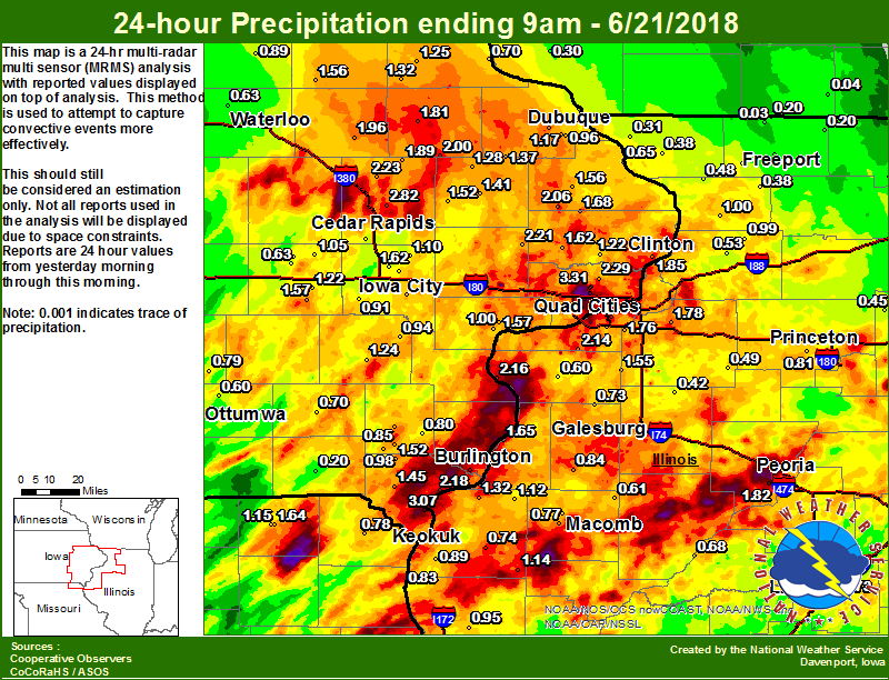 |
 |
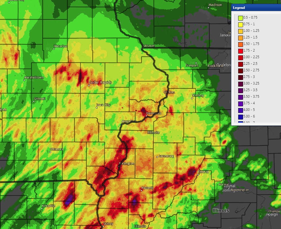
| Figure 1: Local 24-hr Rainfall |
Figure 2: Regional 24-hr Rainfall (ending 7am 6/21) |
24 hour precipitation reports (in Inches),
for eastern Iowa, northwest and west central Illinois,
and northeast Missouri. Reported between Midnight and 9 AM,
Thursday June 21, 2018.

....IOWA....
Davenport 0.9 WNW                5.12
Davenport 3.8 NNW                4.85
Davenport 0.9 SSW                4.53
Davenport Arpt 5 N               4.11
Davenport 2.9 W                  3.95
Le Claire LD14                   3.45
Eldridge 0.7 SSW                 3.31
Bettendorf 2.2 SE                3.21
Burlington 6.5 SSW               3.09
Montrose 0.3 NNW                 3.07
Eldridge 0.6 S                   2.90
Marion 1.7 NNW                   2.82
Burlington 2S                    2.66
Burlington Arpt 2 SW             2.52
Center Point 0.6 NNW             2.43
Park View 0.2 WSW                2.29
Central City 6.7 W               2.23
Lowden                           2.21
Mt Pleasant 1 SSW                2.20
Fort Madison 0.9 NE              2.18
Maquoketa 4W                     2.06
Hopkinton 5.4 WSW                2.00
Quasqueton 0.5 W                 1.96
Pella 4 N                        1.92
Coggon                           1.89
Camanche 1.2 W                   1.85
Mason City ASOS 6 W              1.83
Manchester                       1.81
Keokuk LD19                      1.81
Iowa City 4.5 N                  1.75
Hampton 1 N                      1.70
Delmar 2.3 NW                    1.68
North Liberty 1.0 ENE            1.62
Calamus 2.0 NE                   1.62
Parnell 0.1 SSW                  1.57
Fulton                           1.56
Oelwein AWOS                     1.56
Anamosa 3 SSW                    1.52
West Point 7.5 NW                1.52
Iowa City                        1.49
Oskaloosa 1 NNW                  1.46
Donnellson                       1.45
Center Junction 2.6 W            1.41
NWS Johnston* 5 NNW              1.40
Brighton                         1.38
Cascade                          1.37
Dubuque #3 7 SW                  1.36
Strawberry Point                 1.32
Monticello 1 E                   1.28
Elkader 6SSW                     1.25
Washington                       1.24
De Witt                          1.22
Williamsburg                     1.22
Muscatine 2N                     1.20
Iowa City Arpt                   1.17
Peosta 2.9 E                     1.17
Solon 0.3 ESE                    1.10
Amana 4.7 W                      1.05
Muscatine 1.4 N                  1.00
Salem 1S                         0.98
Dubuque Arpt 7 SW                0.96
Ainsworth 7.4 N                  0.94
Marshalltown 1 NW                0.92
Kalona 7.3 NNW                   0.91
Ames US 30 2 SSE                 0.91
Tripoli 0 N                      0.89
Mason City 1 NNE                 0.85
Salem 3.1 ESE                    0.85
New London 1.5 SW                0.80
Oskaloosa AWOS 9 ESE             0.79
Cresco 1 NE                      0.78
Guttenberg Dam 10                0.70
Fairfield                        0.70
Cedar Rapids Arpt 5 SW           0.70
Marshalltown ASOS 4 N            0.67
Bellevue LD12                    0.65
Waterloo ASOS 5 NW               0.63
Marengo 2.6 SSW                  0.63
Grinnell 2 SW                    0.60
Ottumwa ASOS 6 NNW               0.60
Marengo                          0.55
Centerville 0 NE                 0.51
Albia 3 NNE                      0.40
Grinnell AWOS 2 SSW              0.36
Boone 1 SSW                      0.31
Perry 0 W                        0.28
Dubuque LD11                     0.26
Rathbun Reservoir 2 N            0.25
Toledo 3 N                       0.25
Keosauqua                        0.20
Beaconsfield 1 NNE               0.00
Pella AWOS 2 WSW                 0.00
....ILLINOIS....
Moline 0.9 N                     3.27
New Boston LD17                  2.16
Milan 8.8 SSW                    2.14
Quad City Arpt 3 S               2.06
Peoria ASOS                      1.82
Geneseo 2.0 NW                   1.78
Coal Valley 1.9 SE               1.76
Galesburg                        1.70
Gladstone LD18                   1.65
Ill. City LD16 3 WNW             1.57
New Windsor 2.0 N                1.55
Streator 3 SE                    1.42
Dallas City 3.0 SSE              1.32
Galesburg Arpt 3 SW              1.28
Augusta                          1.14
La Harpe                         1.12
Joliet                           1.01
Chadwick 2.7 WSW                 1.00
Coleta 1.4 SSW                   0.99
Quincy Dam 21                    0.95
Quincy ASOS                      0.95
Princeton 1.1 SE                 0.89
Princeton                        0.89
Warsaw 5.8 SE                    0.89
Roseville 0.6 WNW                0.84
Tiskilwa 2.1 N                   0.81
Colchester 3.5 NE                0.77
Minonk                           0.75
Bentley                          0.74
Alexis 1 SW                      0.73
Lincoln NWS                      0.73
Havana                           0.68
Tuscola                          0.66
Prairie City 2S                  0.61
Aledo                            0.60
Morrison 3.2 E                   0.53
Ottawa 4 SW                      0.50
Kewanee 1 E                      0.49
Romeoville                       0.48
Mount Carroll 6.8 NNW            0.48
Bloomington Airport              0.47
Mendota 2 SE                     0.45
Macomb 3.8 NW                    0.44
Paw Paw 1 E                      0.43
Pearl City 0.4 SW                0.43
Altona                           0.42
Shannon 0.2 S                    0.38
Elizabeth                        0.38
Freeport                         0.35
Galena                           0.31
Steward                          0.23
St Anne                          0.22
Davis 0.5 N                      0.20
Orangeville 2.8 NW               0.20
Jacksonville AWOS                0.19
Decatur Airport                  0.17
Windsor                          0.15
Freeport 2.0 NW                  0.15
Mundelein                        0.12
Ogden                            0.07
Winslow 4.3 ESE                  0.03
Rochelle                         0.03
Rockford ASOS                    0.01
Rochelle AWOS                    0.01
Roscoe 2SE                       0.01
....MISSOURI....
Memphis 0.1 S                    1.64
Memphis                          1.15
Columbia                         0.95
Canton LD20                      0.83
Kahoka 0.6 S                     0.78
Kirksville ASOS                  0.21
Chillicothe 2 NW                 0.00
....WISCONSIN....
Steuben 4SE 3 NE                 1.24
Viroqua                          0.64
Prairie du Chien AWOS            0.59
Lancaster 4WSW                   0.30
La Crosse WFO                    0.21
Madison-ASOS                     0.10
Brodhead 1 SW                    0.04
Watertown-AWOS                   0.02
Beloit-College                   0.01
Allenton-WWTP .6 NW              0.01
Delavan-1 W-WWTP 1 W             0.00
....MINNESOTA....
Theilman 1SSW                    0.55
Preston                          0.33
Grand Meadow                     0.32
 |
Media use of NWS Web News Stories is encouraged! Please acknowledge the NWS as the source of any news information accessed from this site. |
|