Overview
SPC Recap of Severe Weather Event: June 24, 2023​
|
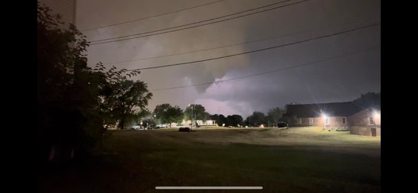 Lance Shaeffer, Davenport, IA |
Tornadoes:
|
Tornado #1 - Davenport, IA
|
||||||||||||||||
The Enhanced Fujita (EF) Scale classifies tornadoes into the following categories:
| EF0 Weak 65-85 mph |
EF1 Moderate 86-110 mph |
EF2 Significant 111-135 mph |
EF3 Severe 136-165 mph |
EF4 Extreme 166-200 mph |
EF5 Catastrophic 200+ mph |
 |
|||||
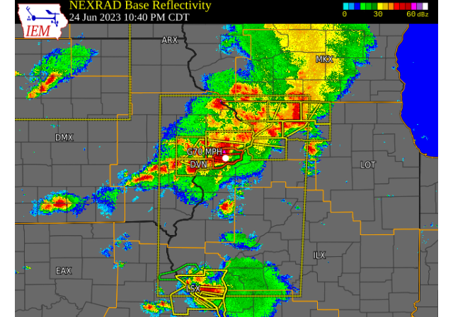
Radar
| IEM RADAR Loop |
 |
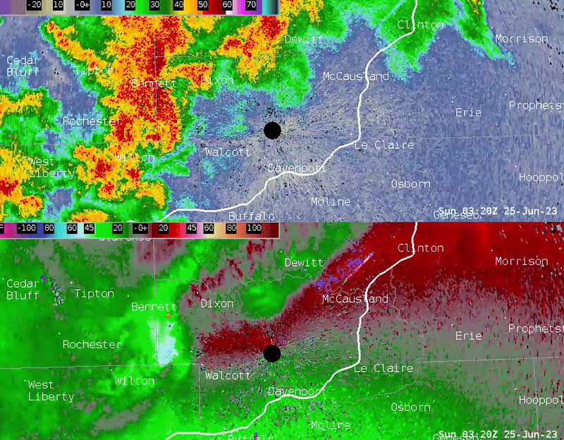 |
| KDVN Reflectivity (top) and Velocity (bottom) from Saturday, June 24 from 10:20 - 11:00 P.M. This shows the hybrid supercell / quasi-linear convective system moving into the Davenport area with strengthening rotation as it passes near to directly over the KDVN radar. |
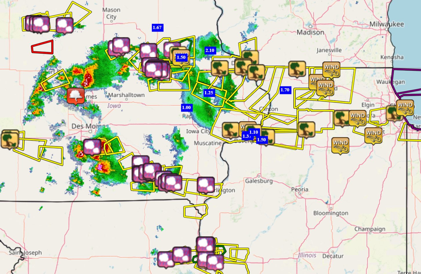
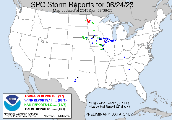
Storm Reports
| IEM Local Storm Reports | SPC Severe Weather Event: June 24, 2023 |
 |
 |
Preliminary Local Storm Report...Summary
National Weather Service Quad Cities IA IL
1046 PM CDT Sun Jun 25 2023
..TIME... ...EVENT... ...CITY LOCATION... ...LAT.LON...
..DATE... ....MAG.... ..COUNTY LOCATION..ST.. ...SOURCE....
..REMARKS..
0610 PM Hail 2 SSE Selma 40.83N 92.14W
06/24/2023 M1.25 inch Van Buren IA Storm Chaser
Report/video from Twitter, hail of quarter
to half dollar size.
0615 PM Hail 2 NNW Douds/Leando 40.86N 92.09W
06/24/2023 E1.50 inch Van Buren IA Public
Report from mPING.
0617 PM Hail 2 NNE Douds/Leando 40.86N 92.08W
06/24/2023 E1.75 inch Van Buren IA Public
Report from mPING.
0625 PM Hail 3 NW Kilbourn 40.84N 92.01W
06/24/2023 M1.25 inch Van Buren IA Storm Chaser
0550 PM Tstm Wnd Gst 2 ENE Hazleton 42.63N 91.86W
06/24/2023 M50 MPH Buchanan IA CO-OP Observer
0820 AM Rain 4 SE Loran 42.17N 89.88W
06/24/2023 M1.80 inch Carroll IL Public
1016 PM Tstm Wnd Dmg 2 NE Oneco 42.50N 89.65W
06/24/2023 Stephenson IL Public
Report of trees down, along with a machine
shed blown over. Time estimated by radar.
1024 PM Tstm Wnd Dmg Orangeville 42.47N 89.64W
06/24/2023 Stephenson IL Law Enforcement
County dispatch reported a few trees down
north of Freeport towards Orangeville. There
was also a report of a blown transformer in
this area. Time estimated by radar.
1025 PM Tstm Wnd Dmg 2 WSW Freeport 42.28N 89.67W
06/24/2023 Stephenson IL Public
18-inch diameter tree downed at Highland
Community College. Time estimated using
radar.
0900 AM Rain 2 SE Scioto Mills 42.33N 89.64W
06/25/2023 M1.30 inch Stephenson IL Public
1057 PM Tstm Wnd Dmg Hampton 41.56N 90.41W
06/24/2023 Rock Island IL Law Enforcement
Couple trees downed on Hubbard Road. Time
estimated using radar.
0855 PM Tstm Wnd Dmg East Dubuque 42.49N 90.64W
06/24/2023 Jo Daviess IL Law Enforcement
Widespread trees and power lines down.
0930 PM Tstm Wnd Dmg Galena 42.42N 90.42W
06/24/2023 Jo Daviess IL Law Enforcement
Trees down with power outages reported.
0717 AM Rain 1 W Galena 42.42N 90.44W
06/25/2023 M0.75 inch Jo Daviess IL Public
1113 PM Tstm Wnd Dmg 2 ESE Osborn 41.50N 90.23W
06/24/2023 Henry IL Law Enforcement
Report of a tree down. Time estimated by
radar.
0800 AM Rain 1 ENE Green River 41.47N 90.32W
06/25/2023 M1.50 inch Henry IL Trained Spotter
Rain total from last evening.
0950 PM Tstm Wnd Dmg Savanna 42.09N 90.15W
06/24/2023 Carroll IL Law Enforcement
Trees down.
0903 AM Rain 4 SE Loran 42.18N 89.87W
06/25/2023 M1.70 inch Carroll IL Trained Spotter
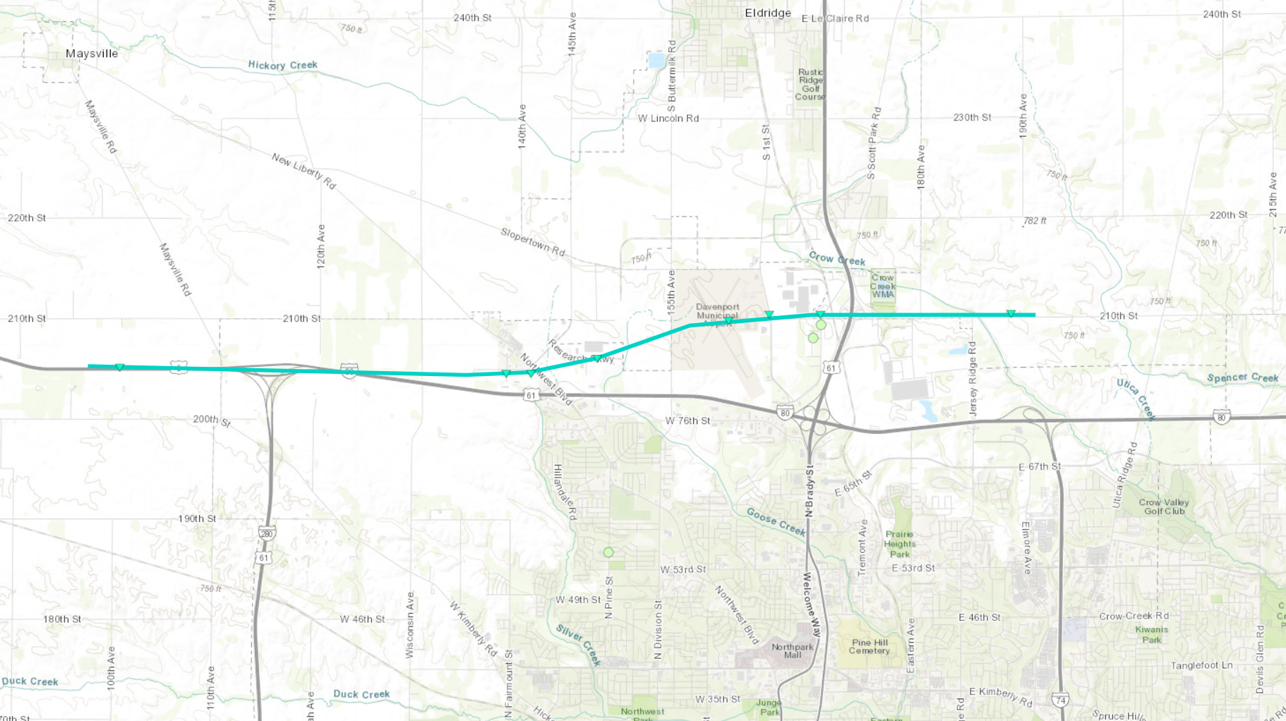
1031 PM Tornado 3 S Maysville 41.61N 90.71W
06/24/2023 Scott IA NWS Storm Survey
A tornado developed about 2 miles east of
Walcott along Interstate 80. The tornado
tracked east and caused sporadic minor tree
and structure damage at the Northwest
Boulevard exit just north of I-80. The
tornado then moved across the Davenport
Airport, and caused damage to canopies,
tents, and equipment. The tornado passed
just south of the NWS office, then continued
east, producing minor tree and structure
damage along 210th St. The tornado followed
an intermittent path of around 9.6 miles,
and was on the ground for about 14 minutes.
The tornado was rated EF-0, with maximum
estimated winds around 75 mph. Occasional
minor tree damage was also observed south of
the path, due to straight line winds.
1040 PM Tstm Wnd Gst Davenport Municipality 41.61N 90.59W
06/24/2023 M70 MPH Scott IA ASOS
ASOS.
1209 AM Tstm Wnd Dmg Bettendorf 41.57N 90.48W
06/25/2023 Scott IA Law Enforcement
Trees down in Bettendorf.
1238 AM Rain 1 SE Davenport 41.54N 90.60W
06/25/2023 E1.40 inch Scott IA Public
0408 AM Rain 1 SE Davenport 41.54N 90.59W
06/25/2023 M1.33 inch Scott IA Trained Spotter
0522 AM Rain 2 NNE Credit Island 41.52N 90.60W
06/25/2023 M1.37 inch Scott IA Trained Spotter
0654 AM Rain 1 NNE Bettendorf 41.58N 90.47W
06/25/2023 M1.10 inch Scott IA Trained Spotter
1045 PM Rain 1 NE Fairfax 41.93N 91.76W
06/24/2023 M1.20 inch Linn IA Public
0407 AM Rain 3 NNE Cedar Rapids 42.01N 91.66W
06/25/2023 M1.45 inch Linn IA Trained Spotter
storm total.
0924 AM Rain 1 ENE Fairfax 41.93N 91.76W
06/25/2023 M1.00 inch Linn IA Trained Spotter
0658 PM Tstm Wnd Dmg Houghton 40.78N 91.61W
06/24/2023 Lee IA Public
Couple trees downed and some siding damage.
Time estimated using radar.
0920 PM Hail Argyle 40.53N 91.57W
06/24/2023 M1.00 inch Lee IA Public
Delayed report via social media.
0357 AM Rain 2 NNE Stone City 42.14N 91.33W
06/25/2023 M1.25 inch Jones IA Trained Spotter
0906 PM Tstm Wnd Dmg Saint Donatus 42.36N 90.54W
06/24/2023 Jackson IA Public
A large tree branch broke off a healthy
tree. Time estimated by radar.
0928 PM Tstm Wnd Dmg Maquoketa 42.07N 90.67W
06/24/2023 Jackson IA Public
Numerous small branches downed. Time
estimated using radar.
0701 AM Rain Parnell 41.58N 92.01W
06/25/2023 M0.68 inch Iowa IA Public
0806 PM Tstm Wnd Dmg Dyersville 42.48N 91.12W
06/24/2023 Dubuque IA Trained Spotter
large tree limb down.
0830 PM Rain 1 W Dubuque 42.51N 90.72W
06/24/2023 M1.17 inch Dubuque IA Public
0841 PM Tstm Wnd Dmg Durango 42.56N 90.78W
06/24/2023 Dubuque IA Emergency Mngr
Large tree fell across Highway 3.
0853 PM Tstm Wnd Dmg 1 E Dubuque 42.51N 90.67W
06/24/2023 Dubuque IA 911 Call Center
Sheriffs Office reported trees and
powerlines down in the city of Dubuque.
0853 PM Tstm Wnd Dmg 2 SE Dubuque 42.49N 90.67W
06/24/2023 Dubuque IA 911 Call Center
Sheriffs office reported trees and
powerlines down around the city.
0737 PM Hail 3 ESE Lowell 40.81N 91.39W
06/24/2023 M1.00 inch Des Moines IA Trained Spotter
0737 PM Tstm Wnd Dmg 3 SE Lowell 40.81N 91.39W
06/24/2023 Des Moines IA Trained Spotter
4 to 5 inch tree limbs down along with lots
of small branches.
1018 PM Tstm Wnd Dmg Durant 41.60N 90.91W
06/24/2023 Cedar IA Emergency Mngr
Report of tree limbs down in Durant. A tree
was blown over onto a homes roof. .
1018 PM Tstm Wnd Dmg Durant 41.60N 90.92W
06/24/2023 Cedar IA Law Enforcement
Trees down across roads. Also baseball
diamond fence damaged.
0840 PM Rain 3 ENE Hazleton 42.64N 91.86W
06/24/2023 M1.50 inch Buchanan IA Trained Spotter
|
|
Rain Reports
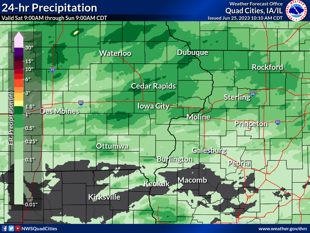 |
||||||||
|
||||||||
Environment
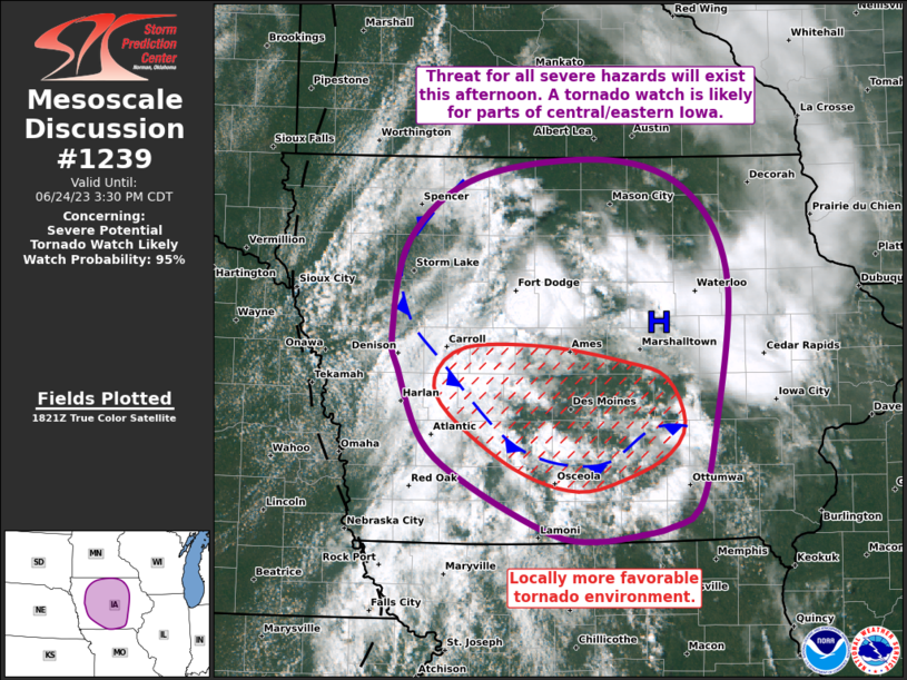 |
 |
 |
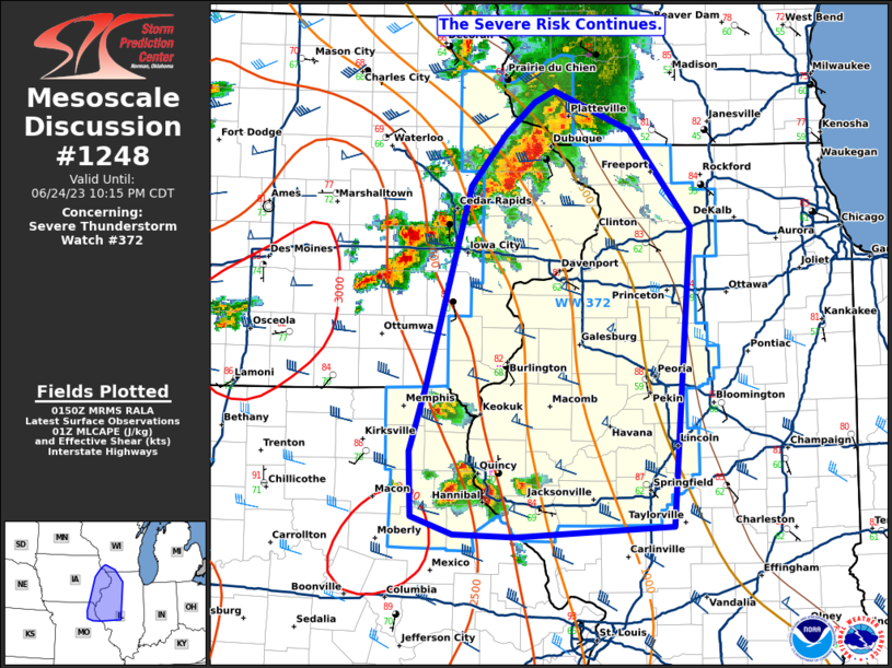 |
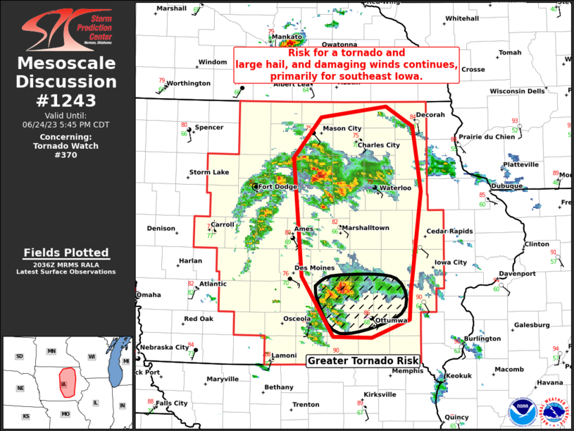
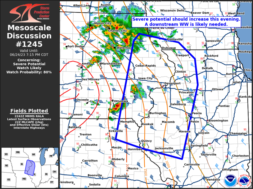
| MD 1239 | MD 1243 | MD 1245 | MD 1248 |
 |
|||
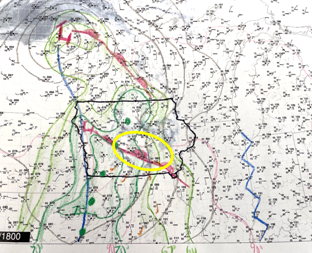
| 1 PM surface weather map highlighting the warm front and markedly increasing dew points. This would be the area where multiple supercell thunderstorms would develop over south central Iowa, including one that tracked into southeast Iowa late in the afternoon, producing up to tennis ball size hail near Ottumwa and golf ball size hail in Van Buren County. As the low pressure itself tracked northeast, along with strengthening upper level winds, it resulted in increasing coverage of thunderstorms during the mid to late evening that tracked across northeast Iowa and northwest Illinois, as well as the Quad Cities metro. | |||
 |
Media use of NWS Web News Stories is encouraged! Please acknowledge the NWS as the source of any news information accessed from this site. |
|