
Dangerous heat will expand from the Gulf Coast into the Southern Plains and Desert Southwest through week's end. Additional extreme heat impacting the Pacific Northwest will shift to the northern Plains by the weekend. Tropical Storm Bertha is expected to continue to impact portions of the northern Gulf Coast from the western Florida Panhandle to southeastern Louisiana through tonight. Read More >
Overview
|
Two rounds of storms tracked across portions of eastern IA and northwest IL on Monday bringing torrential rain, occasional lightning, and gusty winds. The first round moved through late morning and early afternoon along Interstate 80 from Iowa City, to the Quad Cities, towards Princeton IL. Rain amounts over 1 inch were common with some totals over 3 inches reported in Bureau county in IL. This caused some localized flash flooding occurred with these storms. The second round of storms developed after 7pm across northeast IA and southern WI. These tracked southeast into northern IL with gusty winds and torrential rain reported. |
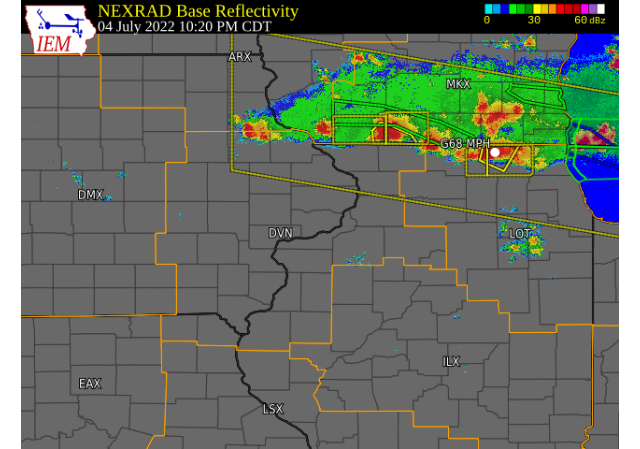 Radar Image : Courtesy Iowa Environment Mesonet Interactive Loop Link |
Storm Reports
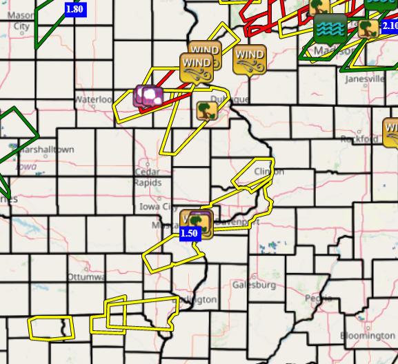
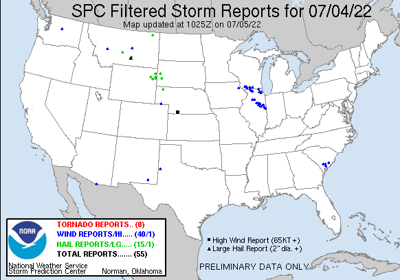
| Interactive Storm Report Map (IEM) | SPC Storm Reports |
 |
 |
PRELIMINARY LOCAL STORM REPORT...SUMMARY
NATIONAL WEATHER SERVICE QUAD CITIES IA IL
958 AM CDT TUE JUL 5 2022

..TIME...   ...EVENT...      ...CITY LOCATION...     ...LAT.LON...
..DATE...   ....MAG....      ..COUNTY LOCATION..ST.. ...SOURCE....
            ..REMARKS..

1027 AM     HEAVY RAIN       2 SE WINDHAM            41.60N 91.74W
07/04/2022  M1.67 INCH       JOHNSON            IA   PUBLIC

            RAINFALL IN PAST HOUR.

1054 AM     HEAVY RAIN       LOWDEN                  41.86N 90.92W
07/04/2022  M0.56 INCH       CEDAR              IA   CO-OP OBSERVER

            RAIN AMOUNT IN PAST HALF HOUR, 30 MPH WINDS
            OBSERVED.

1145 AM     HEAVY RAIN       JESUP                   42.48N 92.07W
07/04/2022  M1.67 INCH       BUCHANAN           IA   TRAINED SPOTTER

            STORM TOTAL.

1149 AM     HEAVY RAIN       1 NNE OAKDALE           41.71N 91.60W
07/04/2022  M1.42 INCH       JOHNSON            IA   PUBLIC

            TOTAL RAINFALL THIS MORNING.

1158 AM     HEAVY RAIN       2 SE IOWA CITY          41.64N 91.51W
07/04/2022  M1.90 INCH       JOHNSON            IA   TRAINED SPOTTER

            STORM TOTAL.

1245 PM     HEAVY RAIN       1 NW ELDRIDGE           41.64N 90.59W
07/04/2022  M2.05 INCH       SCOTT              IA   NWS EMPLOYEE

            RAINFALL OVER THE PAST 2 HOURS. SOME MINOR
            FLOODING IN BACKYARDS.

1251 PM     HEAVY RAIN       2 WNW BETTENDORF        41.57N 90.51W
07/04/2022  M1.78 INCH       SCOTT              IA   TRAINED SPOTTER

            FORMER NWS EMPLOYEE.

0100 PM     HEAVY RAIN       2 NNE CREDIT ISLAND     41.52N 90.60W
07/04/2022  M1.88 INCH       SCOTT              IA   TRAINED SPOTTER


0115 PM     HEAVY RAIN       1 W BETTENDORF          41.56N 90.49W
07/04/2022  M1.58 INCH       SCOTT              IA   TRAINED SPOTTER


0130 PM     HEAVY RAIN       ERIE                    41.66N 90.08W
07/04/2022  M1.00 INCH       WHITESIDE          IL   TRAINED SPOTTER


0140 PM     HEAVY RAIN       1 ENE GREEN RIVER       41.47N 90.32W
07/04/2022  M2.25 INCH       HENRY              IL   TRAINED SPOTTER


0150 PM     HEAVY RAIN       1 NW DAVENPORT          41.56N 90.62W
07/04/2022  M2.01 INCH       SCOTT              IA   TRAINED SPOTTER


0157 PM     TSTM WND DMG     2 S PRINCETON           41.35N 89.47W
07/04/2022                   BUREAU             IL   PUBLIC

            12 INCH DIAMETER TREE DOWN. RELAYED BY LOT.

0200 PM     FLASH FLOOD      PRINCETON               41.37N 89.46W
07/04/2022                   BUREAU             IL   EMERGENCY MNGR

            SEVERAL ROADS IN TOWN IMPASSABLE DUE TO HIGH
            WATER.

0200 PM     HEAVY RAIN       1 SE DAVENPORT          41.54N 90.59W
07/04/2022  M1.67 INCH       SCOTT              IA   TRAINED SPOTTER

            RAINFALL BETWEEN ABOUT 11 AM AND 2 PM.

0210 PM     FLASH FLOOD      SPRING VALLEY           41.33N 89.20W
07/04/2022                   BUREAU             IL   EMERGENCY MNGR

            ROAD WASHED OUT IN TOWN.

0210 PM     FLASH FLOOD      1 WSW DEPUE             41.33N 89.31W
07/04/2022                   BUREAU             IL   PUBLIC

            STREET FLOODING IN DEPUE. FLOWING WATER
            ESTIMATED 6 INCHES DEEP. VIDEO ON SOCIAL
            MEDIA.

0230 PM     TSTM WND GST     1 NW MC NABB            41.19N 89.23W
07/04/2022  M74 MPH          PUTNAM             IL   TRAINED SPOTTER

            HIGHEST WIND LASTED 5 MIN, WITH WINDS OVER
            55 MPH LASTING APPROX. 10 MIN. TORRENTIAL
            RAIN OCCURRED DURING ENTIRE TIME.

0230 PM     TSTM WND DMG     1 NW MC NABB            41.19N 89.23W
07/04/2022                   PUTNAM             IL   TRAINED SPOTTER

            GARAGE DOOR DAMAGED ALONG WITH A FEW TREES
            DOWN. BROAD AREA OF HEAVILY LEANING CORN TO
            THE WEST, EAST, AND SOUTH OF PROPERTY.
            CORRECTS PREVIOUS TSTM WND DMG REPORT FROM 1
            NW MC NABB.

0250 PM     TSTM WND DMG     ORANGEVILLE             42.47N 89.64W
07/04/2022                   STEPHENSON         IL   TRAINED SPOTTER

            8 TO 12 INCH DIAMETER BASED ON PHOTO SHARED
            ON SOCIAL MEDIA. TIME OF THE EVENT WAS
            ESTIMATED USING RADAR.

0250 PM     HEAVY RAIN       1 SE PRINCETON          41.37N 89.45W
07/04/2022  M3.08 INCH       BUREAU             IL   CO-OP OBSERVER


0320 PM     HEAVY RAIN       2 SW MANLIUS            41.44N 89.69W
07/04/2022  M4.00 INCH       BUREAU             IL   TRAINED SPOTTER


0326 PM     TSTM WND DMG     RIDOTT                  42.30N 89.48W
07/04/2022                   STEPHENSON         IL   TRAINED SPOTTER

            8 INCH DIAMETER LIMB DOWN ON WASHINGTON
            STREET IN RIDOTT. TIME ESTIMATED BASED OFF
            OF RADAR.

0330 PM     HEAVY RAIN       3 NNE ATKINSON          41.46N 89.99W
07/04/2022  M2.28 INCH       HENRY              IL   COCORAHS


0415 PM     HEAVY RAIN       PARK VIEW               41.69N 90.54W
07/04/2022  M1.28 INCH       SCOTT              IA   NWS EMPLOYEE


0730 PM     HEAVY RAIN       1 SSW CORDOVA           41.67N 90.33W
07/04/2022  M1.50 INCH       ROCK ISLAND        IL   TRAINED SPOTTER

            RAINFALL TODAY.
Rain Reports
| Local 24-hr Rainfall | Regional 24-hr Rainfall |
.png) |
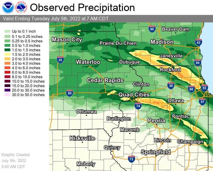 |
24 hour precipitation reports (in Inches),
for eastern Iowa, northwest and west central Illinois,
and northeast Missouri. Reported between Midnight and 9 AM,
Tuesday July 05, 2022.

....IOWA....
Riverdale 0.5 N                  2.14
Iowa City Arpt                   1.90
North Liberty 0.7 SSW            1.89
Bettendorf 1.6 W                 1.79
Coralville 1.4 S                 1.76
Eldridge 0.6 S                   1.74
West Branch 2.0 NNW              1.71
Strawberry Point                 1.68
Davenport 0.9 WNW                1.67
Tipton 0.7 N                     1.63
Newton 1 NE                      1.62
Marshalltown 1 NW                1.60
West Liberty 0.7 NNW             1.50
Waukon 3N                        1.47
Grinnell 2 SW                    1.40
Davenport Arpt                   1.31
Park View 0.2 WSW                1.28
Grinnell AWOS 2 SSW              1.22
Iowa City                        1.20
NWS Johnston* 5 NNW              1.11
Marshalltown ASOS 4 N            1.08
North English                    1.08
Le Claire 1.8 NNE                1.03
Marengo                          1.02
Muscatine 2N                     0.98
Toledo 3 N                       0.92
Parnell 0.1 SSW                  0.90
Waterloo ASOS 5 NW               0.88
Solon 0.3 ESE                    0.87
Cedar Rapids Arpt                0.87
Ely 0.5 SE                       0.85
Marengo 2.6 SSW                  0.82
Oelwein 1E                       0.82
Lowden                           0.71
Elkader 6SSW                     0.67
Guttenberg Dam 10                0.67
Marengo 3.6 N                    0.64
Maquoketa                        0.63
Williamsburg                     0.62
Oelwein AWOS                     0.60
Fayette 1 NW                     0.60
Mason City 1 NNE                 0.60
Mount Auburn 2.2 NNW             0.58
Hampton 1 N                      0.56
Rickardsville 0.2 W              0.51
Dubuque Arpt                     0.48
Fairfax 4.0 NW                   0.47
Anamosa 3 SSW                    0.46
Marion 1.7 NNW                   0.45
Center Point 0.6 NNW             0.42
Wellman 4.0 E                    0.41
Asbury 0.4 SW                    0.41
Camanche 1.2 W                   0.40
Dubuque #3 7 SW                  0.40
Mason City ASOS 6 W              0.39
Palo 4.4 SSW                     0.38
Central City 6.7 W               0.34
Boone 1 SSW                      0.34
Monticello 1 E                   0.30
Charlotte 1.9 WNW                0.26
Ainsworth 7.4 N                  0.19
Washington 5.8 SW                0.18
Washington                       0.13
Pella AWOS 2 WSW                 0.11
Ottumwa ASOS 6 NNW               0.01
Wapello 5.4 SE                   0.00
Wapello 0.2 S                    0.00
Fort Madison 0.9 NE              0.00
West Point 7.5 NW                0.00
Burlington 6.5 SSW               0.00
Salem 3.1 ESE                    0.00
Oskaloosa AWOS 9 ESE             0.00
Fairfield                        0.00
Columbus Jct 2 SSW               0.00
Rathbun Reservoir 2 N            0.00
Burlington 2S                    0.00
Mt Pleasant 1 SSW                0.00
Donnellson                       0.00
Centerville 0 NE                 0.00
Keokuk LD19                      0.00
Burlington Arpt                  0.00
....ILLINOIS....
Princeton 1.1 SE                 3.08
Princeton                        3.08
Atkinson 2.6 NNE                 2.88
Davis 0.5 N                      1.59
Streator 3 SE                    1.55
Coal Valley 2.6 E                1.46
Moline 0.7 NNE                   1.46
Coal Valley 1.9 SE               1.41
Mundelein                        1.06
Winslow 4.3 ESE                  0.95
Ottawa 4 SW                      0.93
Quad City Arpt                   0.92
Rockford Arpt                    0.88
Ridott 0.1 NE                    0.82
Freeport                         0.80
Walnut 5.3 ENE                   0.72
Hanover 0.2 NW                   0.49
Ill. City LD16 3 WNW             0.46
Stockton 3.4 NNE                 0.37
Romeoville                       0.37
Mendota 2 SE                     0.35
Mount Carroll                    0.32
Mount Carroll 6.8 NNW            0.29
Fulton LD13                      0.27
Elizabeth                        0.26
Kewanee 1 E                      0.24
Galva 2.7 NE                     0.23
Rochelle Arpt                    0.21
Freeport 1.7 NW                  0.12
Paw Paw 1 E                      0.11
Joliet Arpt                      0.07
New Boston LD17                  0.03
Galesburg                        0.00
Peoria Arpt                      0.00
Colchester 3.5 NE                0.00
La Harpe 0.7 E                   0.00
Warsaw 5.8 SE                    0.00
Dallas City 3.0 SSE              0.00
Moline 2.5 W                     0.00
Jacksonville Arpt                0.00
Tuscola                          0.00
La Harpe                         0.00
Macomb                           0.00
Decatur Airport                  0.00
Augusta                          0.00
Prairie City 2S                  0.00
Bloomington Airport              0.00
Windsor                          0.00
Ogden                            0.00
Lincoln NWS                      0.00
Gladstone LD18                   0.00
Quincy Arpt                      0.00
Jacksonville 2E                  0.00
Aledo                            0.00
....MISSOURI....
Kahoka 0.6 S                     0.09
Chillicothe Arpt                 0.00
Kirksville Arpt                  0.00
Columbia Arpt                    0.00
Memphis                          0.00
....WISCONSIN....
Monroe 1 W                       2.90
Beloit-College                   1.48
Darlington                       1.45
Prairie du Chien AWOS            1.21
Whitewater                       1.15
La Crosse WFO                    0.96
Madison Arpt                     0.77
Brodhead 1 SW                    0.74
Sullivan-NWS 2 SE                0.70
Delavan-1 W-WWTP 1 W             0.60
Viroqua                          0.51
....MINNESOTA....
Preston                          1.01
Theilman 1SSW                    0.54
Environment
.gif) |
.gif) |
.gif) |
| Figure 1: SPC Day 1 Outlook 1630z | Figure 2: SPC Day 1 Hail Outlook 1630z | Figure 3: SPC Day 1 Wind Outlook 1630z |
.gif) |
 |
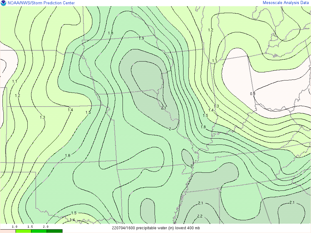 |
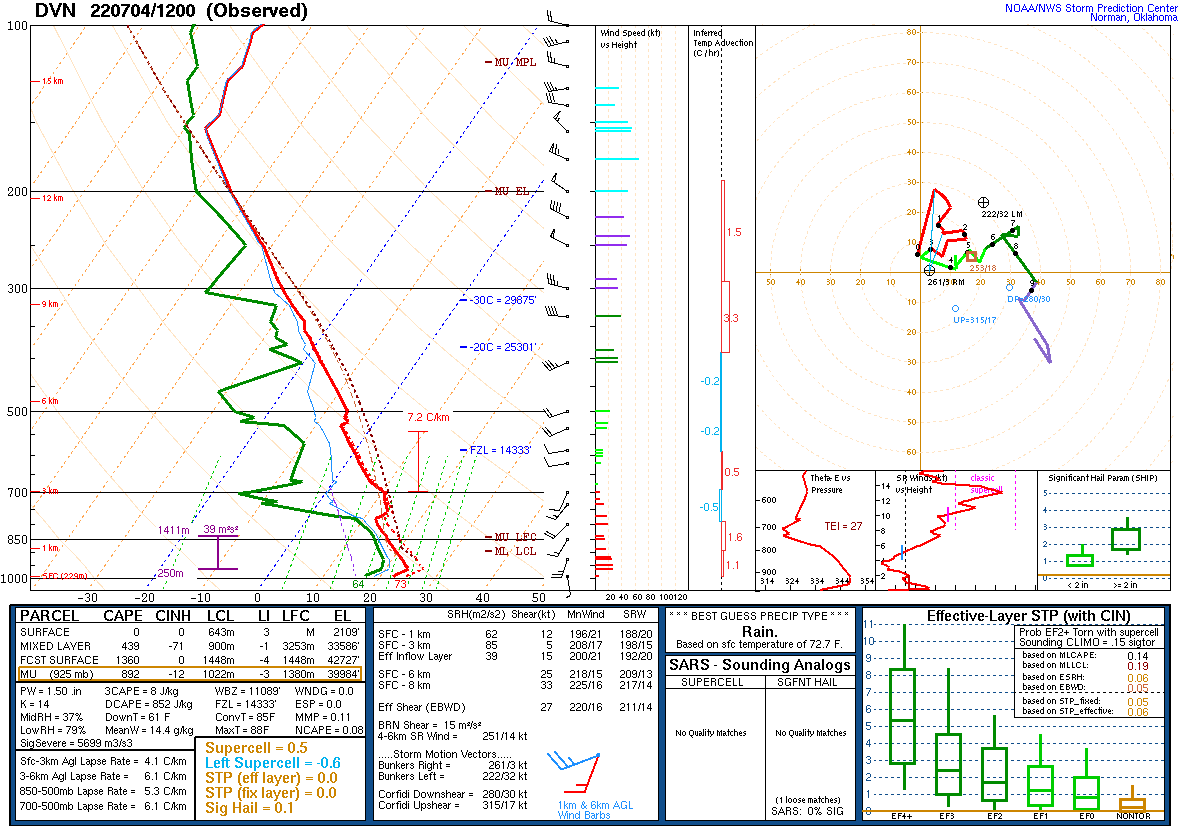
| Figure 4: SPC Day 1 Tornado Outlook 1630z | Figure 5: DVN 12z Sounding | Figure 6: 16z Precipitable Water |
 |
Media use of NWS Web News Stories is encouraged! Please acknowledge the NWS as the source of any news information accessed from this site. |
|

