Overview
|
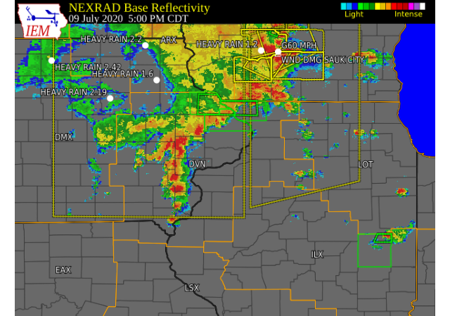
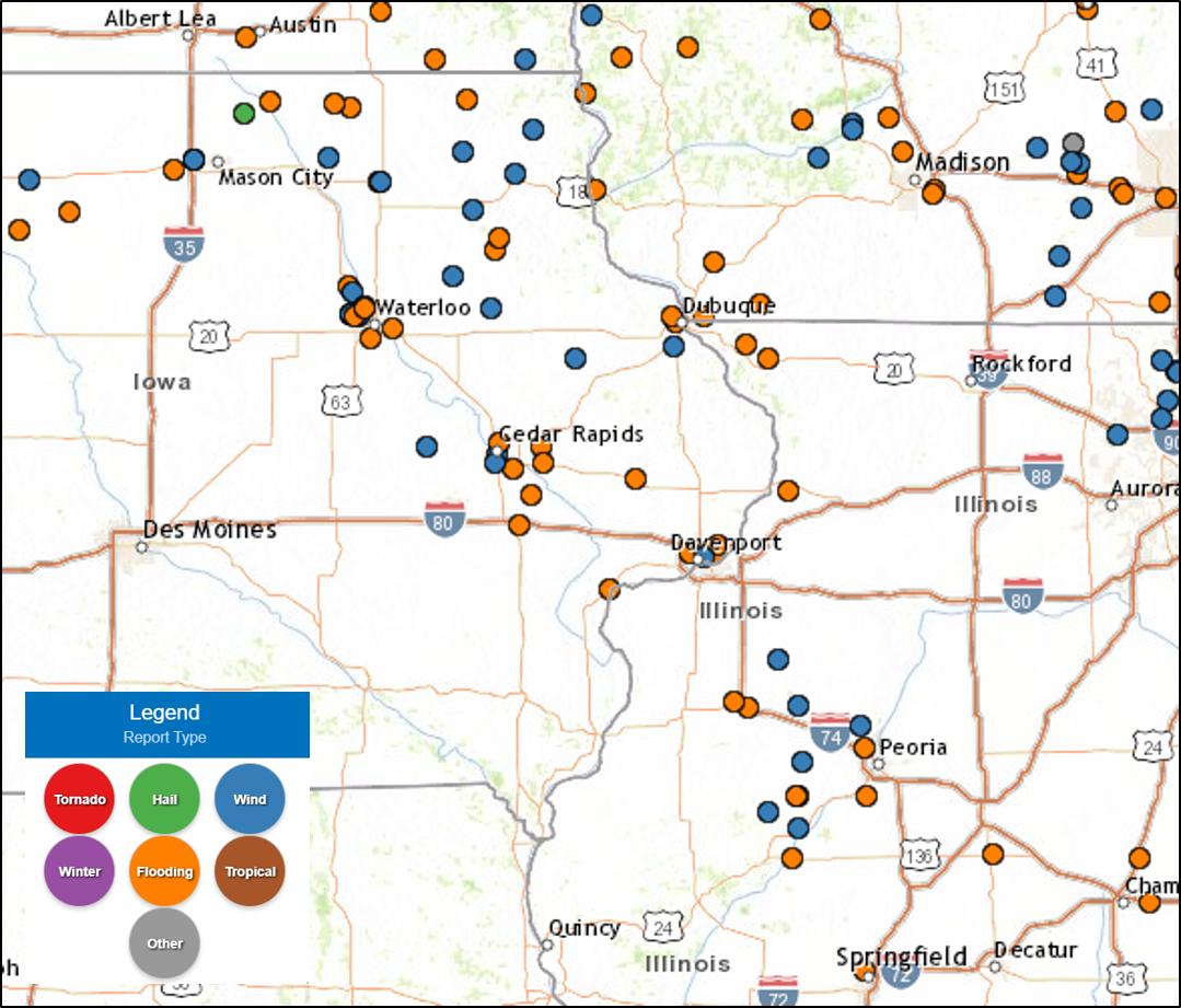
It was a very active afternoon and evening across eastern Iowa and northwest Illinois Thursday afternoon and evening, as a disturbance and trailing cold front moved into the area from the west. This disturbance and front interacted with a hot, humid and very unstable atmosphere, leading to development of showers and thunderstorms. Storms that developed in the early afternoon took advantage of the very high instability, and had no trouble becoming strong, an even severe, in a short amount of time. Storms initially formed along and north of the Highway 30 corridor in eastern Iowa, and produced widespread damage to crops in Buchanan and Delaware counties, and eventually went on to produce a wind gust near 60 MPH at the Dubuque Regional Airport. Storms across this area eventually merged and slowed down, leading to localized rainfall amounts of 4 - 5 inches. This very heavy rainfall produced flash flooding in the Dubuque metro, with law enforcement reporting several road closures along Highway 20. Storms continued to form along a line to the south through the mid afternoon, and reached the Mississippi River around 6 - 7 PM. Several reports of wind damage to trees were received from McDonough county to the Quad Cities metro. A few reports of funnel clouds were also received from the Kirkwood IL area, but no tornado was ever observed. |
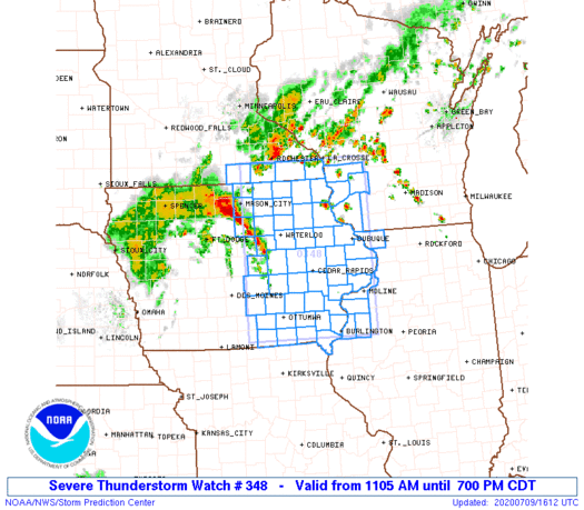 Severe Thunderstorm Watch #348 Graphic |
Storm Reports
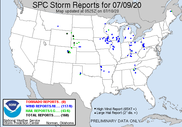
| Interactive Storm Report Map | SPC Storm Reports |
 |
 |
PRELIMINARY LOCAL STORM REPORT...SUMMARY
NATIONAL WEATHER SERVICE QUAD CITIES IA IL
1040 AM CDT FRI JUL 10 2020
..TIME... ...EVENT... ...CITY LOCATION... ...LAT.LON...
..DATE... ....MAG.... ..COUNTY LOCATION..ST.. ...SOURCE....
..REMARKS..
0140 PM TSTM WND DMG 5 SW LAMONT 42.55N 91.71W
07/09/2020 BUCHANAN IA TRAINED SPOTTER
SEVERAL 8-10 INCH TREE BRANCHES SNAPPED OFF
TREES.
0220 PM TSTM WND DMG 2 SE VAN HORNE 41.99N 92.06W
07/09/2020 BENTON IA TRAINED SPOTTER
LARGE TREE LIMB BROKEN OFF TREE, ABOUT 6
INCHES OR LARGER.
0243 PM TSTM WND DMG QUASQUETON 42.40N 91.76W
07/09/2020 BUCHANAN IA EMERGENCY MNGR
EM REPORTS TREE AND CROP DAMAGE IN
QUASQUETON, LIKELY DUE TO MICROBURST WINDS.
TIME ESTIMATED FROM RADAR.
0245 PM TSTM WND DMG WINTHROP 42.47N 91.73W
07/09/2020 BUCHANAN IA EMERGENCY MNGR
EM REPORTS A LARGE SWATCH OF TALL CORN WAS
BLOWN OVER NEAR WINTHROP, LIKELY DUE TO
MICROBURST WINDS. TIME ESTIMATED FROM RADAR.
0320 PM TSTM WND GST 3 S CEDAR RAPIDS 41.93N 91.68W
07/09/2020 M59 MPH LINN IA PUBLIC
RECORDED BY RWIS.
0321 PM TSTM WND DMG 2 W GREELEY 42.59N 91.38W
07/09/2020 DELAWARE IA PUBLIC
WIDESPREAD CORNFIELDS FLATTENED DUE TO THE
WINDS .
0349 PM TSTM WND DMG 1 S CEDAR RAPIDS 41.96N 91.67W
07/09/2020 LINN IA PUBLIC
VIDEO SENT FROM SOCIAL MEDIA OF A TREE
FALLING IN A YARD AND ONTO THE ROAD.
0350 PM TSTM WND DMG HOPKINTON 42.35N 91.25W
07/09/2020 DELAWARE IA PUBLIC
SOCIAL MEDIA SUBMITTED PHOTO OF A TREE
SNAPPED BY THE WIND. AT LEAST 6 INCHES IN
DIAMETER TRUNK. ESTIMATED TIME TO BE
330-345PM, BUT THE RADAR ESTIMATE IS AT
350PM.
0415 PM TSTM WND DMG ANAMOSA 42.11N 91.28W
07/09/2020 JONES IA PUBLIC
REPORT OF A TREE DOWN IN ANAMOSA FROM SOCIAL
MEDIA. TIME ESTIMATED FROM RADAR.
0440 PM TSTM WND DMG 1 SW MENOMINEE 42.46N 90.56W
07/09/2020 JO DAVIESS IL LAW ENFORCEMENT
A FEW TREES DOWN ON HIGHWAY 20 NEAR
MENOMINEE. TIME ESTIMATED FROM RADAR.
0440 PM TSTM WND GST DUBUQUE REGIONAL ARPT 42.40N 90.71W
07/09/2020 M58 MPH DUBUQUE IA ASOS
REPORTED AT DUBUQUE REGIONAL AIRPORT ASOS.
0450 PM HEAVY RAIN UPPER SOUTH AMANA 41.77N 91.97W
07/09/2020 M2.95 INCH IOWA IA TRAINED SPOTTER
0500 PM FLASH FLOOD 1 NNE CENTER GROVE 42.49N 90.71W
07/09/2020 DUBUQUE IA LAW ENFORCEMENT
ALL INTERSECTIONS ON HIGHWAY 20 FROM
UNIVERSITY AVE TO DOWNTON DUBUQUE ARE CLOSED
DUE TO WATER OVER THE ROADWAYS.
0516 PM HEAVY RAIN 3 NNE CEDAR RAPIDS 42.01N 91.66W
07/09/2020 M1.80 INCH LINN IA TRAINED SPOTTER
CORRECTS PREVIOUS HEAVY RAIN REPORT FROM 3
NNE CEDAR RAPIDS. STORM TOTAL ACCUMULATION.
0520 PM HEAVY RAIN MOUNT VERNON 41.93N 91.42W
07/09/2020 M4.00 INCH LINN IA TRAINED SPOTTER
TOTAL RAINFALL IN THE LAST HOUR AND A HALF.
MINOR STREET FLOODING AND PONDING IN YARDS.
0526 PM TSTM WND DMG 5 NNW MUSCATINE 41.49N 91.10W
07/09/2020 MUSCATINE IA PUBLIC
DAMAGE TO A PEACH TREE WITH AROUND 4-6 INCH
DIAMETER BRANCHES BROKEN. REPORT/PICTURE
FROM SOCIAL MEDIA. TIME ESTIMATED FROM
RADAR.
0530 PM FLASH FLOOD 2 ESE MENOMINEE 42.46N 90.51W
07/09/2020 JO DAVIESS IL LAW ENFORCEMENT
VIDEO FROM LAW ENFORCEMENT OF 1.5 LANES OF
HIGHWAY 20 UNDER WATER.
0530 PM HEAVY RAIN 1 NE FAIRFAX 41.93N 91.76W
07/09/2020 M1.90 INCH LINN IA PUBLIC
0531 PM HEAVY RAIN 1 S DUBUQUE 42.50N 90.69W
07/09/2020 M4.00 INCH DUBUQUE IA TRAINED SPOTTER
RAINFALL SINCE 3 PM.
0540 PM TSTM WND DMG WILTON 41.59N 91.01W
07/09/2020 MUSCATINE IA LAW ENFORCEMENT
LAW ENFORCEMENT REPORTED SEVERAL TREES
BRANCHES DOWN FROM STORMS IN THE TOWN OF
WILTON FROM STORMS THURSDAY EVENING. TIME
ESTIMATED FROM RADAR.
0553 PM HEAVY RAIN 2 N ELY 41.90N 91.59W
07/09/2020 M3.00 INCH LINN IA PUBLIC
RAINFALL ACCUMULATION FROM STORMS THIS
AFTERNOON.
0558 PM TSTM WND DMG 1 SE JOY 41.19N 90.86W
07/09/2020 MERCER IL PUBLIC
CORRECTS PREVIOUS TSTM WND DMG REPORT FROM 1
SE JOY. RECEIVED A PHOTO FROM SOCIAL MEDIA
OF A FIELD OF CORN BLOWN OVER, LIKELY DUE TO
MICROBURST FROM STORMS. TIME ESTIMATED FROM
RADAR.
0559 PM HEAVY RAIN SOLON 41.80N 91.49W
07/09/2020 M2.11 INCH JOHNSON IA TRAINED SPOTTER
RAINFALL ACCUMULATION SINCE 7AM, MAINLY FROM
THIS AFTERNOON.
0559 PM TSTM WND DMG JOY 41.20N 90.88W
07/09/2020 MERCER IL PUBLIC
SOCIAL MEDIA PICTURE OF A LARGE TREE SNAPPED
IN JOY DUE TO THUNDERSTORM WINDS. TIME
ESTIMATED FROM RADAR.
0611 PM HEAVY RAIN LOWDEN 41.86N 90.92W
07/09/2020 M1.20 INCH CEDAR IA CO-OP OBSERVER
ACCUMULATION IN 30 MINUTES.
0619 PM TSTM WND DMG ALEDO 41.20N 90.73W
07/09/2020 MERCER IL PUBLIC
PHOTO FROM SOCIAL MEDIA SHOWING A DOWNED
POWER POLE IN ALEDO; LP TANK NEXT TO IT WAS
ALSO BLOWN OVER WITH DAMAGE TO CORN NEARBY.
TIME ESTIMATED FROM RADAR.
0621 PM TSTM WND DMG ANDALUSIA 41.44N 90.73W
07/09/2020 ROCK ISLAND IL PUBLIC
LARGE TREE BRANCH DOWN DUE TO STRONG WINDS
IN ANDALUSIA, REPORT/PICTURE FROM SOCIAL
MEDIA. TIME ESTIMATED FROM RADAR.
0623 PM TSTM WND DMG 2 WNW LITTLE YORK 41.02N 90.79W
07/09/2020 WARREN IL PUBLIC
HIGHWAY SIGN BLOWN OVER AND DAMAGE TO A CORN
FIELD, LIKELY DUE TO MICROBURST. PICTURE
FROM SOCIAL MEDIA. TIME ESTIMATED FROM
RADAR.
0629 PM HEAVY RAIN 1 NNE UNIVERSITY HEIGHT 41.67N 91.55W
07/09/2020 M1.74 INCH JOHNSON IA PUBLIC
RAINFALL ACCUMULATION FROM THE STORM.
0630 PM TSTM WND DMG 3 ESE DAVENPORT 41.54N 90.54W
07/09/2020 SCOTT IA NWS EMPLOYEE
3 INCH DIAMETER BRANCH DOWN. TIME ESTIMATED
FROM RADAR.
0634 PM FUNNEL CLOUD 3 N KIRKWOOD 40.92N 90.75W
07/09/2020 WARREN IL EMERGENCY MNGR
RELAYED A REPORT OF A FUNNEL CLOUD. TIME
ESTIMATED USING RADAR.
0635 PM TSTM WND DMG 2 WSW RIVERDALE 41.53N 90.51W
07/09/2020 SCOTT IA PUBLIC
CORRECTS PREVIOUS TSTM WND DMG REPORT FROM 2
WSW RIVERDALE. SOCIAL MEDIA POST OF A LARGE
TREE SNAPPED NEAR THE CORNER OF MISSISSIPPI
BLVD AND 16TH STREET IN BETTENDORF. TIME
ESTIMATED FROM RADAR.
0648 PM HEAVY RAIN 1 ESE MUSCATINE 41.41N 91.06W
07/09/2020 M2.25 INCH MUSCATINE IA TRAINED SPOTTER
STORM TOTAL RAIN.
0649 PM HEAVY RAIN 2 WNW DUBUQUE 42.52N 90.72W
07/09/2020 M1.75 INCH DUBUQUE IA TRAINED SPOTTER
STORM TOTAL RAINFALL.
0653 PM HEAVY RAIN 3 SSE PARALTA 41.99N 91.43W
07/09/2020 M2.30 INCH LINN IA TRAINED SPOTTER
STORM TOTAL ACCUMULATION.
0654 PM HEAVY RAIN 2 SSE DAVENPORT 41.54N 90.59W
07/09/2020 M1.60 INCH SCOTT IA TRAINED SPOTTER
RAINFALL IN 30 MINUTES.
0700 PM HEAVY RAIN 2 SSE DAVENPORT 41.54N 90.59W
07/09/2020 M2.10 INCH SCOTT IA TRAINED SPOTTER
RAINFALL TOTAL.
0715 PM HEAVY RAIN 3 SW CENTER JUNCTION 42.08N 91.11W
07/09/2020 M1.43 INCH JONES IA PUBLIC
0740 PM TSTM WND DMG PRAIRIE CITY 40.62N 90.47W
07/09/2020 MCDONOUGH IL TRAINED SPOTTER
REPORTED SEVERAL 2 TO 3 INCH DIAMETER
BRANCHES DOWN.
0750 PM HEAVY RAIN LOWDEN 41.86N 90.92W
07/09/2020 M2.05 INCH CEDAR IA CO-OP OBSERVER
RAINFALL 530-730 PM.
0754 PM HEAVY RAIN 1 NW DAVENPORT 41.56N 90.62W
07/09/2020 M1.08 INCH SCOTT IA TRAINED SPOTTER
RAINFALL IN ONE HOUR.
0850 PM HEAVY RAIN 2 W CEDAR RAPIDS 41.98N 91.71W
07/09/2020 M1.54 INCH LINN IA TRAINED SPOTTER
RAINFALL TOTAL.
0853 PM HEAVY RAIN 1 ENE GALENA TERRITORY 42.41N 90.31W
07/09/2020 M5.00 INCH JO DAVIESS IL TRAINED SPOTTER
TOTAL RAINFALL SINCE 3 PM.
0854 PM HEAVY RAIN 3 ENE GARDEN PLAIN 41.81N 90.08W
07/09/2020 M1.10 INCH WHITESIDE IL TRAINED SPOTTER
RAINFALL THIS EVENING.
0917 PM HEAVY RAIN 1 W BETTENDORF 41.56N 90.49W
07/09/2020 M1.85 INCH SCOTT IA TRAINED SPOTTER
MOST OF THE RAIN FELL FROM 630 PM TO 730 PM
THIS EVENING.
1006 PM HEAVY RAIN 2 W WOODBINE 42.35N 90.19W
07/09/2020 M1.23 INCH JO DAVIESS IL TRAINED SPOTTER
OCCURRED IN 3 HOUR PERIOD FROM 5P-8P.
1007 PM HEAVY RAIN 2 NNE BETTENDORF 41.59N 90.47W
07/09/2020 M1.97 INCH SCOTT IA TRAINED SPOTTER
OCCURRED EARLIER THIS EVENING AND FELL IN 90
MINUTES.
1208 AM HEAVY RAIN 1 SSW CORDOVA 41.67N 90.33W
07/10/2020 M1.80 INCH ROCK ISLAND IL TRAINED SPOTTER
FROM AFTERNOON/EVENING STORMS.
0600 AM HEAVY RAIN 2 SE EAST DUBUQUE 42.48N 90.61W
07/10/2020 M3.31 INCH JO DAVIESS IL COCORAHS
COCORAHS STATION IL-JD-11 EAST DUBUQUE 1.7
SE.
0600 AM HEAVY RAIN 3 NE CEDAR RAPIDS 42.00N 91.63W
07/10/2020 M1.44 INCH LINN IA COCORAHS
COCORAHS STATION IA-LN-31 CEDAR RAPIDS 2.7
NE.
0600 AM HEAVY RAIN ELY 41.87N 91.58W
07/10/2020 M1.43 INCH LINN IA COCORAHS
COCORAHS STATION IA-LN-3 ELY 0.5 SE.
0600 AM HEAVY RAIN 1 NNW CENTER POINT 42.19N 91.78W
07/10/2020 M1.15 INCH LINN IA COCORAHS
COCORAHS STATION IA-LN-30 CENTER POINT 0.6
NNW.
0600 AM HEAVY RAIN 2 ESE FAIRVIEW 42.08N 91.30W
07/10/2020 M2.08 INCH JONES IA CO-OP OBSERVER
CO-OP OBSERVER STATION AMOI4 ANAMOSA 3 SSW.
0600 AM HEAVY RAIN 3 WNW NEWPORT 41.75N 91.52W
07/10/2020 M1.81 INCH JOHNSON IA COCORAHS
COCORAHS STATION IA-JH-29 SOLON 4.2 SSW.
0600 AM HEAVY RAIN RICKARDSVILLE 42.58N 90.88W
07/10/2020 M1.86 INCH DUBUQUE IA COCORAHS
COCORAHS STATION IA-DB-21 RICKARDSVILLE 0.2
W.
0630 AM HEAVY RAIN ELIZABETH 42.32N 90.23W
07/10/2020 M1.54 INCH JO DAVIESS IL CO-OP OBSERVER
CO-OP OBSERVER STATION EZBI2 ELIZABETH.
0630 AM HEAVY RAIN 4 NNE LAFAYETTE 42.20N 91.65W
07/10/2020 M1.50 INCH LINN IA COCORAHS
COCORAHS STATION IA-LN-7 CENTRAL CITY 6.7 W.
0633 AM HEAVY RAIN 2 NNW MARION 42.06N 91.61W
07/10/2020 M1.52 INCH LINN IA COCORAHS
COCORAHS STATION IA-LN-27 MARION 1.7 NNW.
0700 AM HEAVY RAIN PROPHETSTOWN 41.67N 89.94W
07/10/2020 M1.29 INCH WHITESIDE IL COCORAHS
COCORAHS STATION IL-WD-18 PROPHETSTOWN 0.2
SW.
0700 AM HEAVY RAIN 3 SSW MALVERN 41.82N 89.90W
07/10/2020 M1.20 INCH WHITESIDE IL COCORAHS
COCORAHS STATION IL-WD-5 MORRISON 3.2 E.
0700 AM HEAVY RAIN 1 SSW COLETA 41.89N 89.81W
07/10/2020 M1.29 INCH WHITESIDE IL COCORAHS
COCORAHS STATION IL-WD-8 COLETA 1.4 SSW.
0700 AM HEAVY RAIN ALEXIS 41.06N 90.57W
07/10/2020 M1.40 INCH WARREN IL CO-OP OBSERVER
CO-OP OBSERVER STATION ALXI2 ALEXIS.
0700 AM HEAVY RAIN 2 ESE FREEPORT 42.28N 89.60W
07/10/2020 M1.40 INCH STEPHENSON IL COCORAHS
COCORAHS STATION IL-SP-14 FREEPORT 1.7 ESE.
0700 AM HEAVY RAIN 1 NNE MOLINE 41.49N 90.48W
07/10/2020 M2.03 INCH ROCK ISLAND IL COCORAHS
COCORAHS STATION IL-RI-13 MOLINE 0.7 NNE.
0700 AM HEAVY RAIN 3 NNE STOCKTON 42.40N 89.99W
07/10/2020 M1.11 INCH JO DAVIESS IL COCORAHS
COCORAHS STATION IL-JD-8 STOCKTON 3.4 NNE.
0700 AM HEAVY RAIN 2 NNW WARNER 41.45N 90.40W
07/10/2020 M1.07 INCH HENRY IL COCORAHS
COCORAHS STATION IL-HY-15 COAL VALLEY 2.6 E.
0700 AM HEAVY RAIN 2 SE COAL VALLEY 41.43N 90.42W
07/10/2020 M1.14 INCH HENRY IL COCORAHS
COCORAHS STATION IL-HY-5 COAL VALLEY 1.9 SE.
0700 AM HEAVY RAIN 2 NE MISSISSIPPI PALISA 42.16N 90.15W
07/10/2020 M1.45 INCH CARROLL IL COCORAHS
COCORAHS STATION IL-CR-17 SAVANNA 4.6 N.
0700 AM HEAVY RAIN 6 SSE ELMOVILLE 42.19N 90.02W
07/10/2020 M1.05 INCH CARROLL IL COCORAHS
COCORAHS STATION IL-CR-12 MOUNT CARROLL 6.8
NNW.
0700 AM HEAVY RAIN 1 SW WASHINGTON 41.28N 91.71W
07/10/2020 M1.04 INCH WASHINGTON IA CO-OP OBSERVER
CO-OP OBSERVER STATION WSHI4 WASHINGTON 2
SSW.
0700 AM HEAVY RAIN 1 N RIVERDALE 41.54N 90.47W
07/10/2020 M1.72 INCH SCOTT IA COCORAHS
COCORAHS STATION IA-ST-42 RIVERDALE 0.5 N.
0700 AM HEAVY RAIN 1 S MUSCATINE 41.41N 91.07W
07/10/2020 M1.33 INCH MUSCATINE IA CO-OP OBSERVER
CO-OP OBSERVER STATION MCTI4 MUSCATINE.
0700 AM HEAVY RAIN 1 N MUSCATINE 41.44N 91.07W
07/10/2020 M1.00 INCH MUSCATINE IA COCORAHS
COCORAHS STATION IA-MC-10 MUSCATINE 1.4 N.
0700 AM HEAVY RAIN 2 N MUSCATINE 41.45N 91.07W
07/10/2020 M1.01 INCH MUSCATINE IA COCORAHS
COCORAHS STATION IA-MC-13 MUSCATINE 2.1 N.
0700 AM HEAVY RAIN 4 NNE MUSCATINE 41.47N 91.05W
07/10/2020 M1.87 INCH MUSCATINE IA CO-OP OBSERVER
CO-OP OBSERVER STATION MSTI4 2 N MUSCATINE.
0700 AM HEAVY RAIN 4 NNE FAIRFAX 41.98N 91.76W
07/10/2020 M1.03 INCH LINN IA COCORAHS
COCORAHS STATION IA-LN-50 CEDAR RAPIDS 4.6
W.
0700 AM HEAVY RAIN 2 WNW MARION 42.04N 91.63W
07/10/2020 M1.55 INCH LINN IA COCORAHS
COCORAHS STATION IA-LN-41 CEDAR RAPIDS 5.2
NNE.
0700 AM HEAVY RAIN 2 WSW CEDAR RAPIDS 41.95N 91.71W
07/10/2020 M1.53 INCH LINN IA COCORAHS
COCORAHS STATION IA-LN-39 CEDAR RAPIDS 2.5
WSW.
0700 AM HEAVY RAIN 1 NNW MONTICELLO MUNICI 42.24N 91.17W
07/10/2020 M1.10 INCH JONES IA CO-OP OBSERVER
CO-OP OBSERVER STATION MCLI4 MONTICELLO.
0700 AM HEAVY RAIN SOLON 41.80N 91.49W
07/10/2020 M2.13 INCH JOHNSON IA COCORAHS
COCORAHS STATION IA-JH-1 SOLON 0.3 ESE.
0700 AM HEAVY RAIN BELLEVUE 42.26N 90.43W
07/10/2020 M1.25 INCH JACKSON IA COCORAHS
COCORAHS STATION IA-JC-5 BELLEVUE 0.3 SSW.
0700 AM HEAVY RAIN 1 W MAQUOKETA MUNICIPAL 42.05N 90.75W
07/10/2020 M1.85 INCH JACKSON IA CO-OP OBSERVER
CO-OP OBSERVER STATION MKTI4 MAQUOKETA.
0700 AM HEAVY RAIN 1 NNE WEST AMANA 41.81N 91.97W
07/10/2020 M2.15 INCH IOWA IA COCORAHS
COCORAHS STATION IA-IA-6 AMANA 4.7 W.
0700 AM HEAVY RAIN 1 NW DUBUQUE REGIONAL A 42.41N 90.73W
07/10/2020 M2.48 INCH DUBUQUE IA CO-OP OBSERVER
CO-OP OBSERVER STATION DUBI4 DUBUQUE 7 SSW.
0700 AM HEAVY RAIN ASBURY 42.51N 90.77W
07/10/2020 M2.69 INCH DUBUQUE IA COCORAHS
COCORAHS STATION IA-DB-20 ASBURY 0.4 SW.
0700 AM HEAVY RAIN 3 SSW JULIEN 42.44N 90.79W
07/10/2020 M4.27 INCH DUBUQUE IA COCORAHS
COCORAHS STATION IA-DB-16 PEOSTA 2.9 E.
0700 AM HEAVY RAIN 2 SSE BUCK CREEK 42.30N 91.34W
07/10/2020 M1.58 INCH DELAWARE IA COCORAHS
COCORAHS STATION IA-DW-6 HOPKINTON 5.4 WSW.
0700 AM HEAVY RAIN 1 SSE MANCHESTER 42.47N 91.45W
07/10/2020 M1.27 INCH DELAWARE IA CO-OP OBSERVER
CO-OP OBSERVER STATION MHRI4 MANCHESTER.
0700 AM HEAVY RAIN 2 ENE HAZLETON 42.63N 91.86W
07/10/2020 M1.49 INCH BUCHANAN IA CO-OP OBSERVER
CO-OP OBSERVER STATION SNYI4 STANLEY 3 WSW.
0700 AM HEAVY RAIN 5 SW LAMONT 42.55N 91.71W
07/10/2020 M2.24 INCH BUCHANAN IA COCORAHS
COCORAHS STATION IA-BC-9 WINTHROP 5.6 NNE.
0700 AM HEAVY RAIN 1 S BELLE PLAINE 41.88N 92.28W
07/10/2020 M1.49 INCH BENTON IA CO-OP OBSERVER
CO-OP OBSERVER STATION BLLI4 BELLE PLAINE.
0730 AM HEAVY RAIN 2 W BETTENDORF 41.56N 90.51W
07/10/2020 M1.64 INCH SCOTT IA COCORAHS
COCORAHS STATION IA-ST-48 , IA.
0730 AM HEAVY RAIN RICKARDSVILLE 42.58N 90.88W
07/10/2020 M1.87 INCH DUBUQUE IA TRAINED SPOTTER
24-HR RAINFALL TOTAL.
0742 AM HEAVY RAIN 2 WSW SAINT DONATUS 42.35N 90.57W
07/10/2020 M2.50 INCH JACKSON IA TRAINED SPOTTER
STORM TOTAL.
0745 AM HEAVY RAIN 3 SW WINNESHIEK 42.32N 89.57W
07/10/2020 M1.40 INCH STEPHENSON IL TRAINED SPOTTER
24-HR RAINFALL TOTAL.
0745 AM HEAVY RAIN 1 SSW NORTH LIBERTY 41.73N 91.62W
07/10/2020 M2.46 INCH JOHNSON IA COCORAHS
COCORAHS STATION IA-JH-27 NORTH LIBERTY 0.7
SSW.
0800 AM HEAVY RAIN 3 W CENTER JUNCTION 42.11N 91.14W
07/10/2020 M2.39 INCH JONES IA COCORAHS
COCORAHS STATION IA-JN-10 CENTER JUNCTION
2.6 W.
0800 AM HEAVY RAIN 1 S ASBURY 42.51N 90.76W
07/10/2020 M2.67 INCH DUBUQUE IA COCORAHS
COCORAHS STATION IA-DB-22 ASBURY 0.6 S.
0800 AM HEAVY RAIN 1 N INDEPENDENCE 42.48N 91.89W
07/10/2020 M1.14 INCH BUCHANAN IA COCORAHS
COCORAHS STATION IA-BC-7 INDEPENDENCE 1.2 N.
0825 AM HEAVY RAIN 1 N TIPTON 41.78N 91.13W
07/10/2020 M1.00 INCH CEDAR IA COCORAHS
COCORAHS STATION IA-CD-6 TIPTON 0.7 N.
0900 AM HEAVY RAIN 1 W MORRISON 41.81N 89.98W
07/10/2020 M1.40 INCH WHITESIDE IL TRAINED SPOTTER
RAINFALL TOTAL FROM THURSDAY STORMS.
0900 AM HEAVY RAIN 2 NNE LE CLAIRE 41.62N 90.35W
07/10/2020 M1.53 INCH SCOTT IA COCORAHS
COCORAHS STATION IA-ST-1 LE CLAIRE 1.8 NNE
Rainfall Reports
|
Local Rain Map
|
Regional Rain Map (Courtesy of MRCC)
|
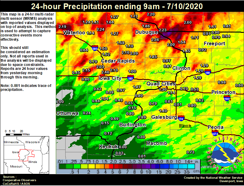
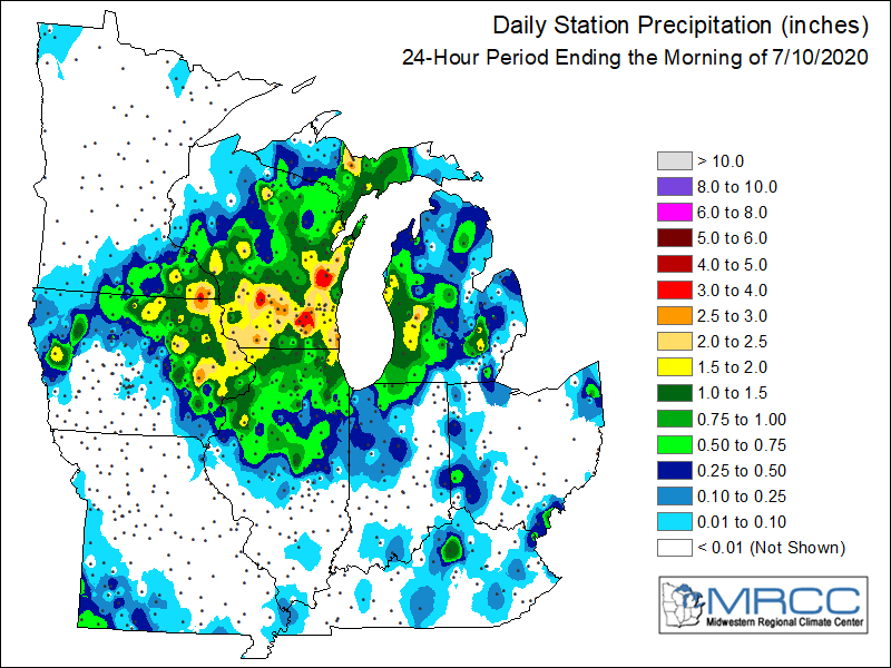
24 hour precipitation reports (in Inches), for eastern Iowa, northwest and west central Illinois, and northeast Missouri. Reported between Midnight and 9 AM, Sunday May 24, 2020. ....IOWA.... Dubuque #3 7 SW 2.48 North Liberty 0.7 SSW 2.46 Mason City ASOS 6 W 2.43 Center Junction 2.6 W 2.39 Dubuque Arpt 2.36 Winthrop 5.6 NNE 2.24 Dubuque LD11 2.23 Waterloo ASOS 5 NW 2.19 Anamosa 1.9 SE 2.16 Amana 4.7 W 2.15 Solon 0.3 ESE 2.13 Anamosa 3 SSW 2.08 Cedar Rapids Arpt 5 SW 2.03 Bellevue LD12 2.00 Mason City 1 NNE 2.00 Muscatine 2N 1.87 Rickardsville 0.2 W 1.86 Maquoketa 4 W 1.85 Riverdale 0.5 N 1.72 Guttenberg Dam 10 1.71 Bettendorf 1.6 W 1.64 Strawberry Point 1.64 Hopkinton 5.4 WSW 1.58 Cedar Rapids 5.2 NNE 1.55 Cedar Rapids 2.5 WSW 1.53 Marion 1.7 NNW 1.52 Central City 6.7 W 1.50 Davenport 0.9 WNW 1.47 Le Claire LD14 1.43 Ely 0.5 SE 1.43 Oelwein 1E 1.41 Elkader 6SSW 1.27 Manchester 1.27 Oelwein AWOS 1.24 Center Point 0.6 NNW 1.15 Independence 1.2 N 1.14 Monticello 1 E 1.10 Washington 1.04 Muscatine 2.1 N 1.01 Tipton 0.7 N 1.00 Muscatine 1.4 N 1.00 Nichols 3.2 SSW 0.97 Camanche 1.2 W 0.97 Charlotte 1.9 WNW 0.97 Davenport Arpt 0.91 Goose Lake 6.4 SSW 0.81 Mediapolis 0.2 WNW 0.80 Fayette 1 NW 0.80 Williamsburg 0.80 Fairfax 4.0 NW 0.79 Eldridge 0.7 SSW 0.77 Iowa City Arpt 0.74 Eldridge 0.6 S 0.74 Hampton 1 N 0.67 Marengo 0.65 Vinton 0.64 Marengo 3.6 N 0.55 West Branch 2.0 NNW 0.53 Waukon 3N 0.52 New London 1.5 SW 0.49 Columbus Jct 2 SSW 0.49 Washington 5.8 SW 0.48 Marengo 2.6 SSW 0.45 Wellman 4.0 E 0.42 Ainsworth 7.4 N 0.39 Toledo 3 N 0.38 Grinnell AWOS 2 SSW 0.36 Wapello 0.2 S 0.35 Iowa City 0.35 Fairfield 0.24 Salem 1S 0.15 Wapello 5.4 SE 0.15 Donnellson 0.12 Marshalltown 1 NW 0.08 Marshalltown ASOS 4 N 0.07 Pella 4 N 0.06 Newton 1 NE 0.05 Pella AWOS 2 WSW 0.05 Burlington Arpt 2 SW 0.02 Boone 1 SSW 0.01 Ames US 30 2 SSE 0.00 NWS Johnston* 5 NNW 0.00 Ottumwa ASOS 6 NNW 0.00 Rathbun Reservoir 2 N 0.00 Perry 0 W 0.00 Centerville 0 NE 0.00 Oskaloosa 1 NNW 0.00 Beaconsfield 1 NNE 0.00 Keokuk LD19 0.00 Oskaloosa AWOS 9 ESE 0.00 ....ILLINOIS.... Galesburg Arpt 3 SW 3.96 Moline 0.7 NNE 2.03 Galesburg 1.97 Mundelein 1.63 Elizabeth 1.54 Savanna 4.6 N 1.45 Freeport 1.7 ESE 1.40 Alexis 1 SW 1.40 Quad City Arpt 1.30 Coleta 1.4 SSW 1.29 Prophetstown 0.2 SW 1.29 Ill. City LD16 3 WNW 1.23 Morrison 3.2 E 1.20 Roscoe 2SE 1.19 Paw Paw 1 E 1.14 Coal Valley 1.9 SE 1.14 Stockton 3.4 NNE 1.11 Ottawa 4 SW 1.08 Coal Valley 2.6 E 1.07 Walnut 5.3 ENE 0.98 Ridott 0.1 NE 0.94 Davis 0.5 N 0.94 Lanark 5.3 N 0.92 Winslow 4.3 ESE 0.91 Orangeville 2.8 NW 0.90 Oquawka 0.5 N 0.89 Freeport 1.7 NW 0.88 Romeoville 0.86 Steward 0.85 Freeport 2.0 NW 0.84 Lincoln NWS 0.83 Galva 0.3 S 0.80 Illinois City 6.7 SW 0.80 Aledo 0.79 Dakota 4.8 NW 0.79 Bloomington Airport 0.77 Peoria ASOS 0.76 Alpha 2.3 N 0.74 Rockford ASOS 0.73 Havana 0.73 Alpha 0.7 N 0.71 Freeport 2.9 WSW 0.70 Geneseo 2.0 NW 0.70 Altona 0.65 Rochelle AWOS 0.63 Kewanee 1 E 0.62 New Windsor 2.0 N 0.61 Woodhull 0.3 ESE 0.61 Gladstone LD18 0.60 Mendota 2 SE 0.60 Princeton 0.59 Tiskilwa 2.1 N 0.59 Joliet 0.59 Princeton 1.1 SE 0.59 Fulton LD13 0.54 Atkinson 2.6 NNE 0.53 Minonk 0.35 La Harpe 0.30 New Boston LD17 0.25 St Anne 0.25 Colchester 3.5 NE 0.10 Ogden 0.09 Macomb 0.05 Warsaw 5.8 SE 0.02 Jacksonville 2E 0.02 Decatur Airport 0.01 Augusta 0.01 Quincy ASOS 0.00 Windsor 0.00 Jacksonville AWOS 0.00 Tuscola 0.00 ....MISSOURI.... Kirksville ASOS 0.05 Chillicothe 2 NW 0.00 Columbia 0.00 ....WISCONSIN.... Watertown-AWOS 2.94 Whitewater 2.79 Darlington 2.60 Madison-ASOS 2.43 Prairie du Chien AWOS 2.37 Lancaster 4WSW 2.20 Allenton-WWTP .6 NW 1.82 La Crosse WFO 1.70 Monroe 1 W 1.41 Viroqua 1.25 Steuben 4SE 3 NE 0.94 Brodhead 1 SW 0.81 Delavan-1 W-WWTP 1 W 0.52 ....MINNESOTA.... Preston 1.6 |
Environment
SPC EVENT REVIEW PAGE: 07/09/2020
 |
 |
 |
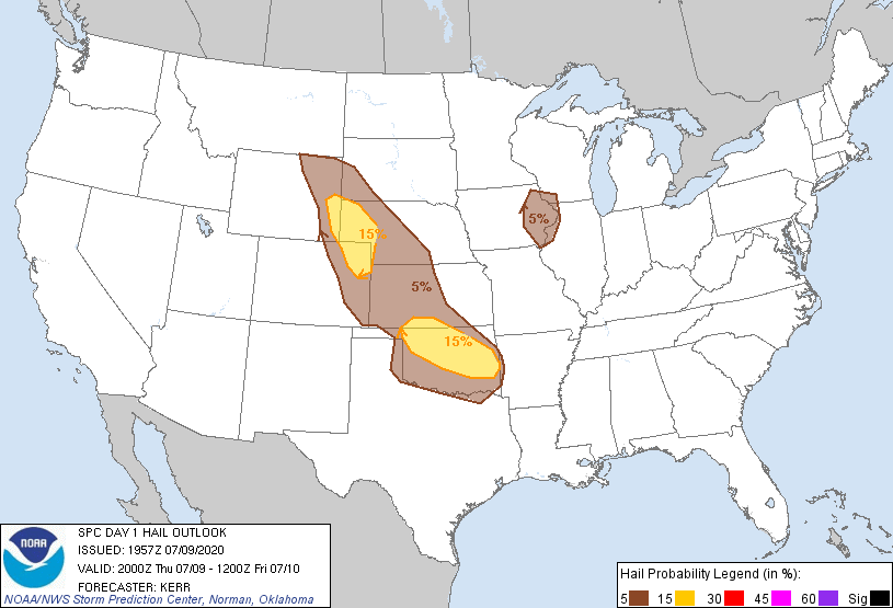 |
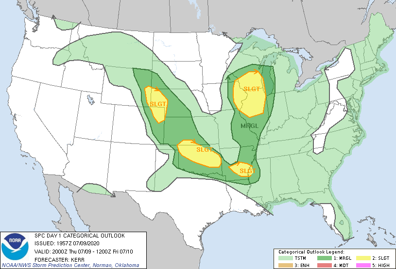
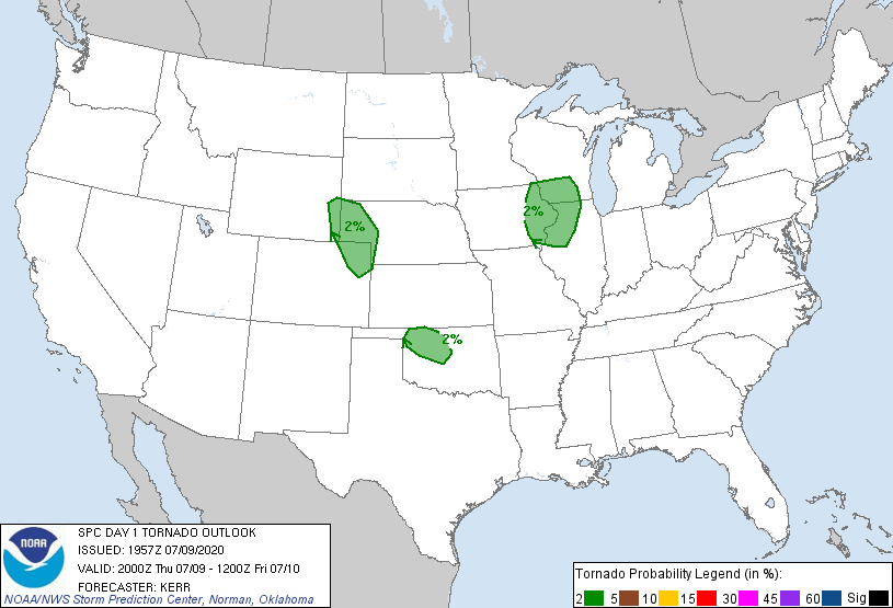
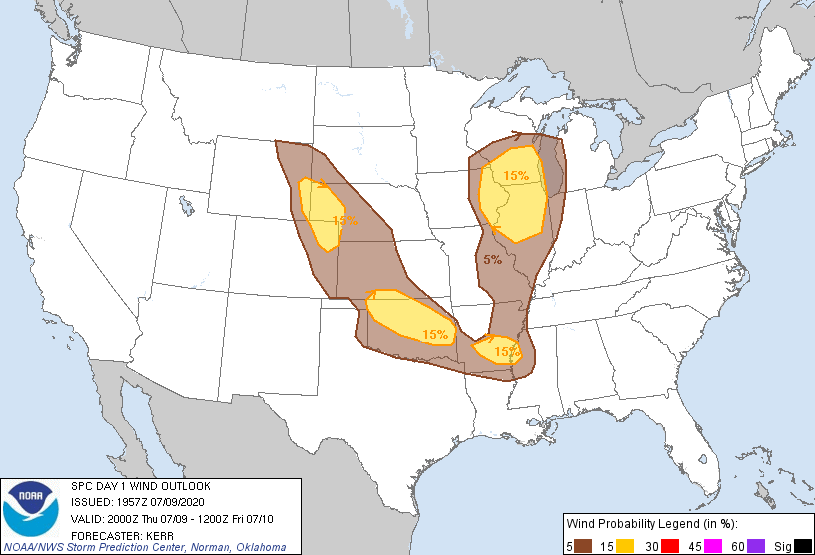
| SPC Categorical Outlook | Tornado Outlook | Wind Outlook | Hail Outlook |
 |
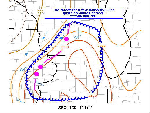 |
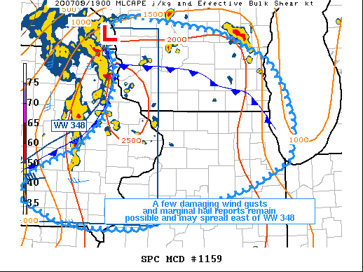
| MCD 1159 (text) | MCD 1162 (text) |
 |
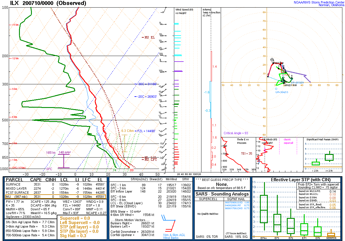 |
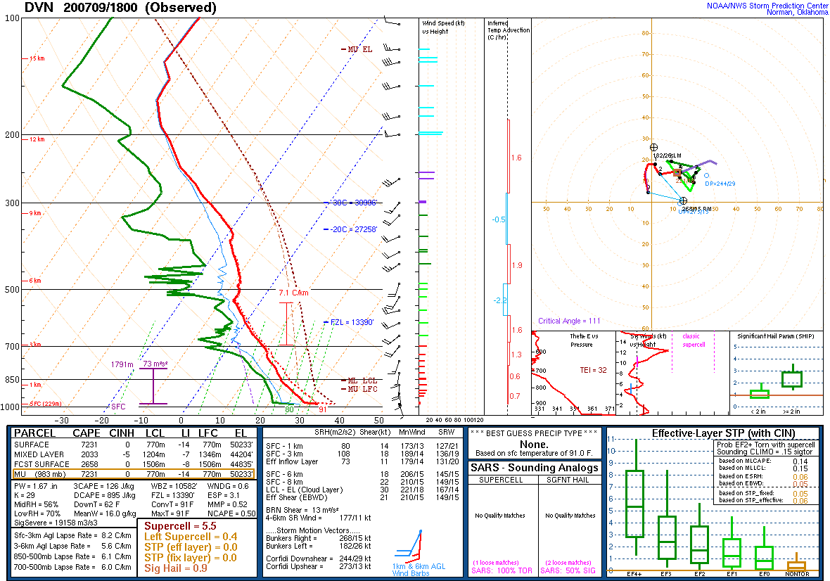
| 1 PM DAVENPORT, IA SOUNDING | 7 PM LINCOLN, IL SOUNDING |
 |
 |
 |
|
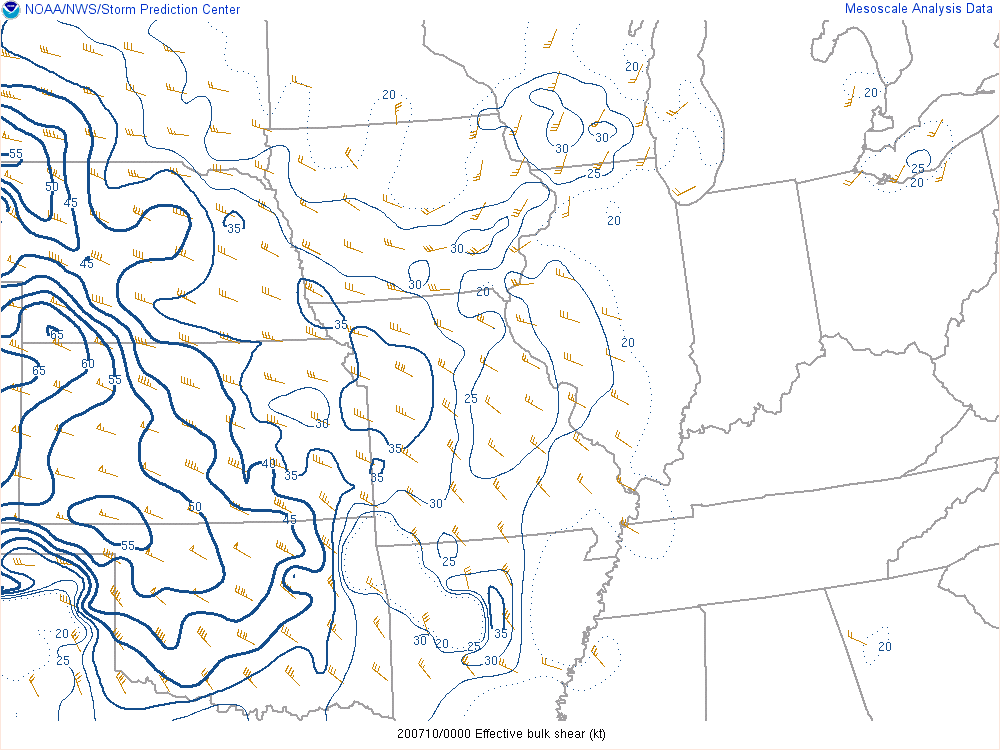
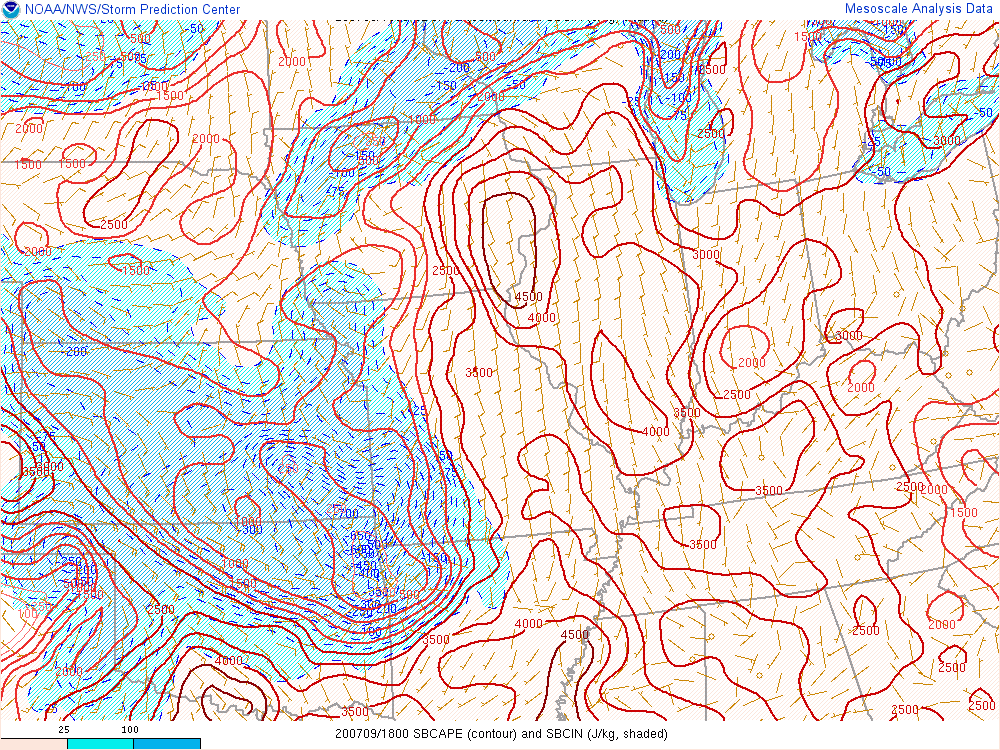
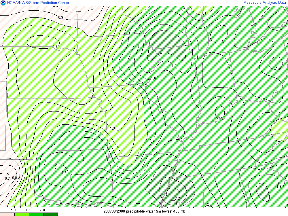
| Effective Bulk Wind Shear Analyzed at 7 PM | Surface Based Convective Availible Potential Energy (SBCAPE) Analyzed at 1 PM | Precipitable Water Analyzed at 6 PM |
 |
Media use of NWS Web News Stories is encouraged! Please acknowledge the NWS as the source of any news information accessed from this site. |
|