Overview
|
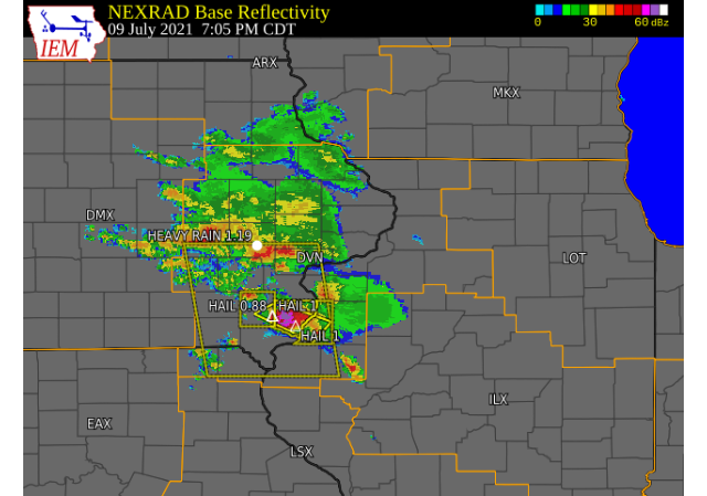
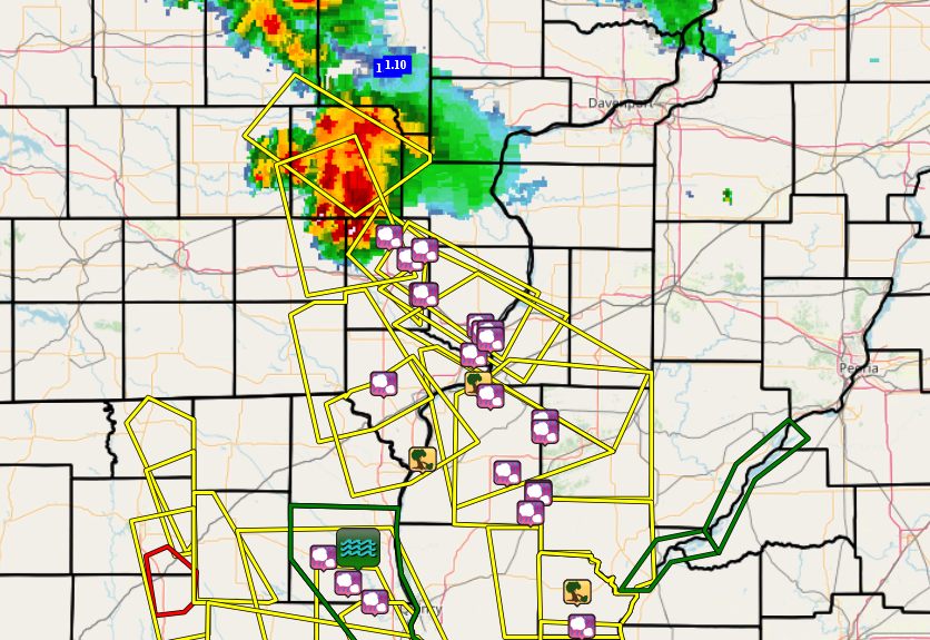
A few supercell thunderstorms developed ahead of a warm front advancing into the forecast area, where they produced gusty winds, heavy rain, and hail up to 3 inches in diameter. Storms initially developed as more discrete supercells early in the evening, with the storm that went through Burlington being one of the more intense storms. Rainfall amounts reached 2 inches or more in some areas, as the anomalously moist environment favored excessive rainfall that can lead to flash flooding. Luckily, we have not received any flash flood reports, but the La Moine River near Colmar has raised to Minor Flood stage due to the recent rains. |
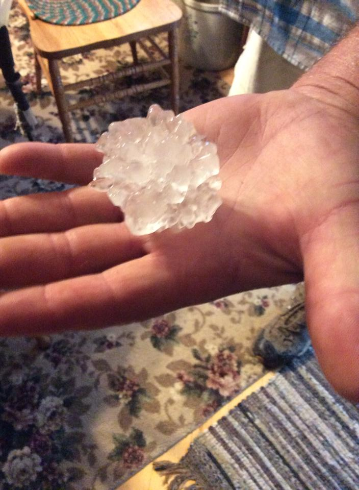 Large Hail 4 Miles South of LaHarpe (sent to Jesse Risley from viewer) |
PRELIMINARY LOCAL STORM REPORT...SUMMARY
NATIONAL WEATHER SERVICE QUAD CITIES IA IL
1139 AM CDT SAT JUL 10 2021

..TIME...   ...EVENT...      ...CITY LOCATION...     ...LAT.LON...
..DATE...   ....MAG....      ..COUNTY LOCATION..ST.. ...SOURCE....
            ..REMARKS..

0806 PM     HAIL             3 SSW BLANDINSVILLE     40.52N 90.89W
07/09/2021  E1.00 INCH       MCDONOUGH          IL   PUBLIC

            REPORT FROM MPING: QUARTER (1.00 IN.).

0806 PM     HAIL             4 E FOUNTAIN GREEN      40.49N 90.89W
07/09/2021  E1.00 INCH       MCDONOUGH          IL   PUBLIC

            MPING REPORT.

0734 PM     TSTM WND DMG     DALLAS CITY             40.64N 91.17W
07/09/2021                   HANCOCK            IL   PUBLIC

            DOWNED TREE BRANCHES.

0735 PM     HAIL             3 SE DALLAS CITY        40.60N 91.12W
07/09/2021  M1.00 INCH       HANCOCK            IL   TRAINED SPOTTER


0753 PM     HAIL             2 N FOUNTAIN GREEN      40.51N 90.97W
07/09/2021  E3.00 INCH       HANCOCK            IL   PUBLIC

            BROADCAST MEDIA RELAYED A REPORT OF 3.0 INCH
            HAIL 2 MILES NORTH OF FOUNTAIN GREEN. CROPS
            WERE DESTROYED WITH DAMAGE TO A BUILDING.
            TIME WAS ESTIMATED USING RADAR.

0806 PM     HAIL             3 ENE BENTLEY           40.36N 91.05W
07/09/2021  E1.25 INCH       HANCOCK            IL   TRAINED SPOTTER

            LASTED OVER 2 MINUTES.

0816 PM     HAIL             1 N PLYMOUTH            40.30N 90.92W
07/09/2021  M2.50 INCH       HANCOCK            IL   TRAINED SPOTTER

            GOLF BALL TO TENNIS BALL SIZE HAIL.

0820 PM     HAIL             PLYMOUTH                40.29N 90.92W
07/09/2021  M1.75 INCH       HANCOCK            IL   TRAINED SPOTTER

            QUARTER TO GOLF BALL SIZE HAIL.

0820 PM     TSTM WND DMG     PLYMOUTH                40.29N 90.92W
07/09/2021                   HANCOCK            IL   TRAINED SPOTTER

            BRANCHES DOWN...ESTIMATED 6 INCHES IN
            DIAMETER.

0823 PM     HAIL             AUGUSTA                 40.23N 90.95W
07/09/2021  M1.00 INCH       HANCOCK            IL   TRAINED SPOTTER

            HEAVY RAIN TOO.

0556 PM     HAIL             1 W WASHINGTON          41.30N 91.70W
07/09/2021  E0.75 INCH       WASHINGTON         IA   PUBLIC

            REPORT FROM MPING: DIME (0.75 IN.).

0854 PM     HAIL             DONNELLSON              40.64N 91.56W
07/09/2021  E1.00 INCH       LEE                IA   PUBLIC


0918 PM     TSTM WND DMG     1 SE KEOKUK             40.40N 91.40W
07/09/2021                   LEE                IA   TRAINED SPOTTER

            CORRECTS PREVIOUS TSTM WND DMG REPORT FROM 1
            SE KEOKUK. TREE DOWN NEAR 16TH ST AND TIMEA
            ST. SEVERAL 6 TO 10 INCH DIAMETER BRANCHES
            DOWN IN TOWN.

0700 PM     HEAVY RAIN       IOWA CITY MUNICIPALITY  41.63N 91.55W
07/09/2021  M1.19 INCH       JOHNSON            IA   ASOS

            1 HOUR RAINFALL TOTAL. ASOS STATION KIOW
            IOWA CITY ARPT.

0730 PM     HEAVY RAIN       2 SE IOWA CITY          41.64N 91.51W
07/09/2021  M1.10 INCH       JOHNSON            IA   TRAINED SPOTTER

            RAINFALL OVER THE PAST HOUR.

0513 PM     HAIL             1 SW WILLIAMSBURG       41.66N 92.02W
07/09/2021  M0.70 INCH       IOWA               IA   TRAINED SPOTTER

            MODERATE RAIN AND DIME SIZED HAIL.

0613 PM     HAIL             SWEDESBURG              41.10N 91.54W
07/09/2021  M1.75 INCH       HENRY              IA   TRAINED SPOTTER

            GOLF BALL HAIL ON 218 NEAR SWEDESBURG. HEAVY
            RAIN WITH NEAR ZERO VISIBILITY.

0630 PM     HAIL             4 WSW MOUNT UNION       41.03N 91.45W
07/09/2021  M0.70 INCH       HENRY              IA   TRAINED SPOTTER

            A FEW DIME SIZED HAIL STONES AND HEAVY RAIN.
            TIME ESTIMATED.

0631 PM     HAIL             MOUNT UNION             41.06N 91.39W
07/09/2021  M1.50 INCH       HENRY              IA   TRAINED SPOTTER


0651 PM     HAIL             1 SE NEW LONDON         40.92N 91.39W
07/09/2021  M1.00 INCH       HENRY              IA   TRAINED SPOTTER

            DIME TO QUARTER SIZED HAIL.

0651 PM     HAIL             1 ESE NEW LONDON        40.92N 91.40W
07/09/2021  M0.88 INCH       HENRY              IA   TRAINED SPOTTER

            NICKEL SIZED HAIL FOR ABOUT 2 MINUTES ENDING
            AROUND 653 PM.

0925 PM     HEAVY RAIN       1 S MOUNT PLEASANT MUNI 40.93N 91.51W
07/09/2021  M0.96 INCH       HENRY              IA   PUBLIC


0947 AM     HEAVY RAIN       1 ESE NEW LONDON        40.92N 91.40W
07/10/2021  M1.51 INCH       HENRY              IA   TRAINED SPOTTER

            24 HOUR TOTAL.

0719 PM     HAIL             1 E WEST BURLINGTON     40.82N 91.16W
07/09/2021  M1.00 INCH       DES MOINES         IA   TRAINED SPOTTER


0720 PM     HAIL             2 WSW SPRING GROVE      40.73N 91.19W
07/09/2021  M1.50 INCH       DES MOINES         IA   TRAINED SPOTTER


0722 PM     HAIL             1 WSW BURLINGTON        40.80N 91.14W
07/09/2021  M1.75 INCH       DES MOINES         IA   TRAINED SPOTTER


0724 PM     HAIL             1 SSE BURLINGTON        40.80N 91.12W
07/09/2021  M1.50 INCH       DES MOINES         IA   TRAINED SPOTTER


0728 PM     HAIL             1 ESE BURLINGTON REGION 40.78N 91.12W
07/09/2021  E2.50 INCH       DES MOINES         IA   PUBLIC

            REPORT FROM MPING: TENNIS BALL (2.50 IN.).

0730 PM     HAIL             1 ENE BURLINGTON REGION 40.79N 91.11W
07/09/2021  U1.50 INCH       DES MOINES         IA   PUBLIC

            REPORT FROM MPING: PING PONG BALL (1.50
            IN.).
Rain Reports
Will be available after 10 AM 7/10.
24 hour precipitation reports (in Inches),
for eastern Iowa, northwest and west central Illinois,
and northeast Missouri. Reported between 6 AM and 9 AM,
Saturday July 10, 2021.

....IOWA....
Allerton 2 S                     2.27
Parnell 0.1 SSW                  2.06
Beaconsfield 1 NNE               1.94
Salem 1S                         1.85
Iowa City Arpt                   1.80
New London 1.5 SW                1.78
NWS Johnston* 5 NNW              1.67
Burlington 0.8 SSE               1.51
Ottumwa ASOS 6 NNW               1.46
Fairfield                        1.46
Burlington Arpt                  1.42
Rathbun Reservoir 2 N            1.40
Oskaloosa AWOS 9 ESE             1.36
Donnellson                       1.35
Centerville 0 NE                 1.28
Iowa City                        1.25
Washington                       1.24
Washington 5.8 SW                1.13
Mason City 1 NNE                 1.08
Amana 4.7 W                      1.06
West Liberty 0.7 NNW             1.04
Coralville 1.3 SE                1.00
Fort Madison 0.9 NE              1.00
Mt Pleasant 1 SSW                0.99
Keokuk LD19                      0.97
Wellman 4.0 E                    0.95
Ames US 30 2 SSE                 0.93
Newton 1 NE                      0.93
Boone 1 SSW                      0.87
Muscatine 2.1 N                  0.77
Wapello 5.4 SE                   0.72
Marengo 3.6 N                    0.63
West Branch 2.0 NNW              0.58
Toledo 3 N                       0.57
Muscatine 2N                     0.55
Grinnell AWOS 2 SSW              0.53
Morning Sun 1.7 E                0.50
Solon 0.3 ESE                    0.36
Cedar Rapids Arpt                0.33
Tripoli 0 N                      0.30
Ely 0.5 SE                       0.28
Davenport 0.9 WNW                0.28
Davenport 2.9 W                  0.27
Marshalltown 1 NW                0.27
Independence 1.2 N               0.27
Fayette 1 NW                     0.25
Riverdale 0.5 N                  0.25
Marshalltown ASOS 4 N            0.25
Davenport Arpt                   0.24
Eldridge 0.6 S                   0.24
Strawberry Point                 0.23
Fairfax 4.0 NW                   0.22
Le Claire 1.8 NNE                0.21
Park View 0.2 WSW                0.20
Guttenberg Dam 10                0.20
Oelwein AWOS                     0.19
Mount Vernon 0.7 ENE             0.17
Calamus 2.0 NE                   0.17
Elkader 6SSW                     0.15
De Witt                          0.15
Peosta 2.9 E                     0.15
Mason City ASOS 6 W              0.14
Cedar Rapids 2.7 NE              0.12
Anamosa 3 SSW                    0.12
Center Point 0.6 NNW             0.12
Central City 6.7 W               0.11
Winthrop 5.6 NNE                 0.11
Camanche 1.2 W                   0.10
Cedar Rapids 5.2 NNE             0.10
Rickardsville 0.2 W              0.10
Marion 1.7 NNW                   0.10
Maquoketa                        0.04
Pella AWOS 2 WSW                 0.04
Dubuque #3 7 SW                  0.04
Charlotte 1.9 WNW                0.03
Dubuque Arpt                     0.03
Waterloo ASOS 5 NW               0.03
Bellevue LD12                    0.02
Hampton 1 N                      0.02
....ILLINOIS....
Augusta                          1.84
Stronghurst 0.4 SSW              1.38
Dallas City 3.0 SSE              1.37
La Harpe                         1.28
Gladstone LD18                   1.22
Prairie City 2S                  0.93
Colchester 3.5 NE                0.60
Oquawka 0.5 N                    0.55
Aledo                            0.51
Macomb 3.8 NW                    0.45
New Boston LD17                  0.44
Macomb                           0.44
Galesburg                        0.40
Quincy ASOS                      0.32
Moline 0.7 NNE                   0.27
Atkinson 2.6 NNE                 0.27
Geneseo 2.0 NW                   0.26
Coal Valley 1.9 SE               0.25
Coal Valley 2.6 E                0.25
Quad City Arpt                   0.21
Galva 2.7 NE                     0.21
Kewanee 1 E                      0.19
New Windsor 2.0 N                0.17
Alpha 2.3 N                      0.15
Princeton 1.1 SE                 0.13
Princeton                        0.13
Altona                           0.13
Jacksonville AWOS                0.10
Decatur Airport                  0.09
Lincoln NWS                      0.08
Morrison 5.9 SSW                 0.07
Davis 0.5 N                      0.05
Tuscola                          0.05
Walnut 5.3 ENE                   0.05
Peoria ASOS                      0.04
Minonk                           0.04
Streator 3 SE                    0.03
Steward                          0.02
Coleta 1.4 SSW                   0.02
Freeport 2.0 NW                  0.01
Mount Carroll 6.8 NNW            0.01
Joliet                           0.01
Bloomington Airport              0.01
Romeoville                       0.00
Ogden                            0.00
Freeport 2.9 WSW                 0.00
Freeport 1.7 NW                  0.00
Rockford ASOS                    0.00
Mundelein                        0.00
Rochelle AWOS                    0.00
Paw Paw 1 E                      0.00
Freeport                         0.00
St Anne                          0.00
Winslow 4.3 ESE                  0.00
....MISSOURI....
Kirksville ASOS                  3.59
Columbia                         1.58
Chillicothe 2 NW                 0.90
Memphis                          0.61
....WISCONSIN....
Prairie du Chien AWOS            0.03
Brodhead 1 SW                    0.02
Darlington                       0.00
Watertown-AWOS                   0.00
La Crosse WFO                    0.00
Viroqua                          0.00
Madison-ASOS                     0.00
Sullivan-NWS 2 SE                0.00
Whitewater                       0.00
....MINNESOTA....
Preston                          0.02
Theilman 1SSW                    0.00
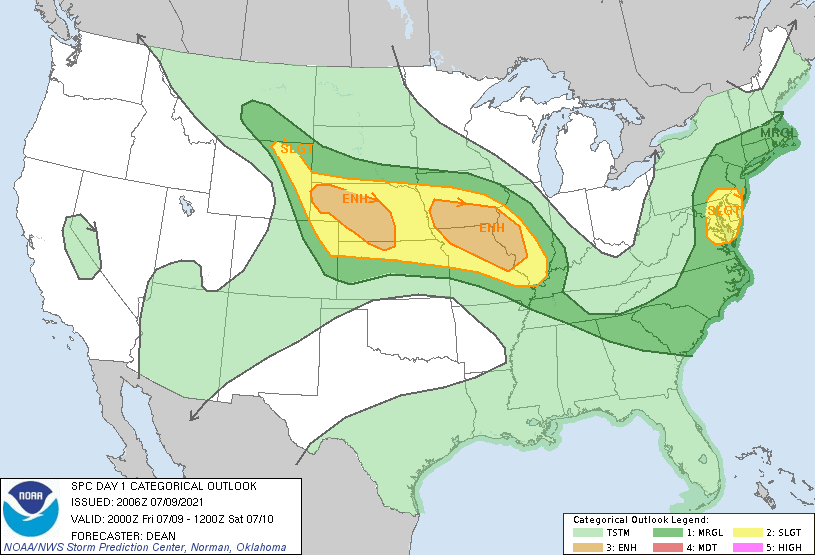
SPC Graphics
 |
 |
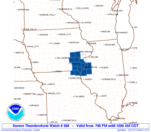 |
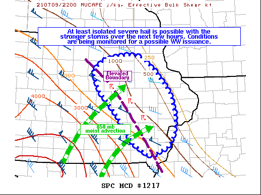
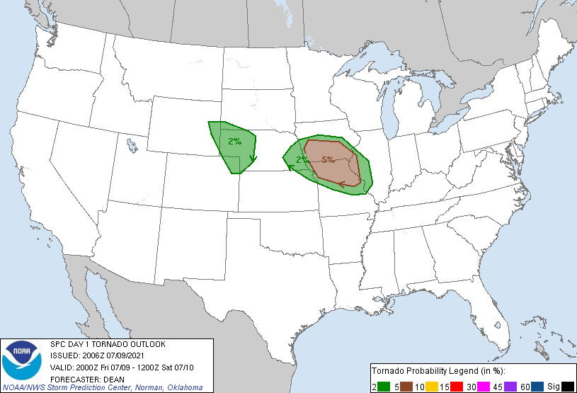
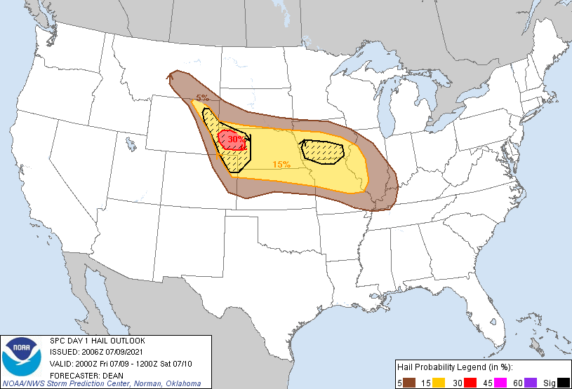
| 20Z Day 1 Outlook | MCD #1217 | Severe Thunderstorm Watch #358 |
 |
 |
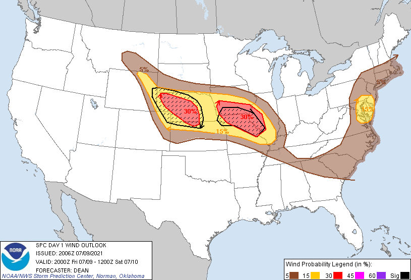 |
| Day 1 Prob Tornado | Day 1 Prob Hail | Day 1 Prob Wind |
 |
Media use of NWS Web News Stories is encouraged! Please acknowledge the NWS as the source of any news information accessed from this site. |
|