Overview
|
Severe thunderstorms developed across eastern Iowa and northwest Illinois Saturday, July 11, 2020, producing widespread wind damage and very large hail. The first line of storms came through during the morning, producing damaging wind gusts and reports of quarter to ping pong ball size hail from Independence IA to Tipton IA. A wind gusts of 65 MPH was measured just west of Independence IA. The second round of thunderstorms developed as a result of an upper level disturbance interacting with an atmosphere characterized by extremely high instability with modest vertical wind shear. Activity initially formed in north central Iowa, producing golf ball to two inch hail from Fort Dodge IA to Waterloo IA. Eventually, storms made their way towards the Cedar Rapids/Iowa City metros, producing widespread wind damage and hail up to baseball size. These storms continued through the Quad Cities metro east towards Princeton IL, Sterling IL and Hennepin IL, producing additional reports of wind damage and winds of 70-90 MPH. Numerous power outages were also reported.
Surrounding Office Event Summaries |
 Sun Illuminating Striations and Mammatus Clouds After Squall Line Exited the Quad Cites Metro (Photo by David Cousins) |
Radar
| Click Here For An Interactive Radar Loop (Courtesy IEM) |
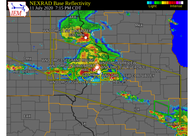 Still shot from KDVN taken at 715 PM as storms moved through the Quad Cities metro |
Storm Reports
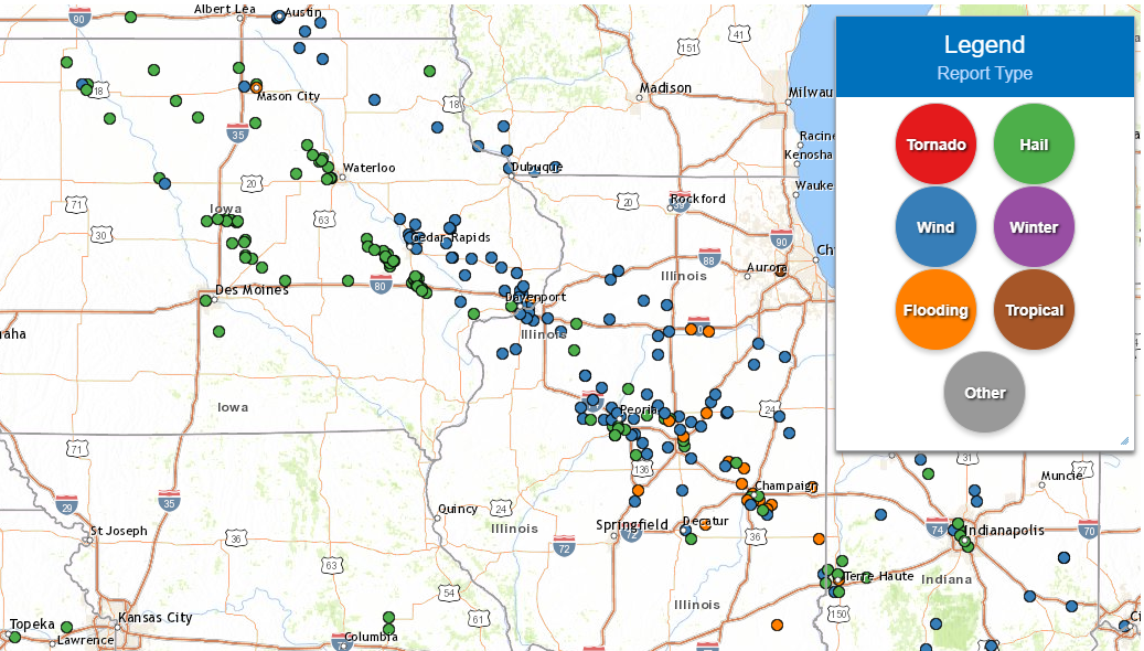
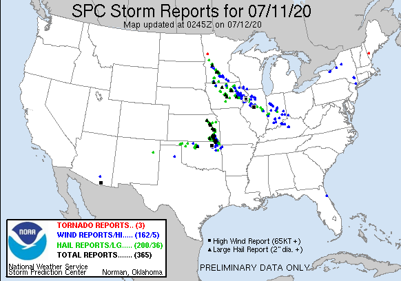
| Interactive Storm Report Map (IEM) | SPC Storm Reports |
 |
 |
PRELIMINARY LOCAL STORM REPORT...SUMMARY
NATIONAL WEATHER SERVICE QUAD CITIES IA IL
458 PM CDT SUN JUL 12 2020
..TIME... ...EVENT... ...CITY LOCATION... ...LAT.LON...
..DATE... ....MAG.... ..COUNTY LOCATION..ST.. ...SOURCE....
..REMARKS..
0925 AM TSTM WND GST 2 ENE HAZLETON 42.63N 91.86W
07/11/2020 M50 MPH BUCHANAN IA TRAINED SPOTTER
0945 AM HAIL 2 SE OTTERVILLE 42.50N 91.92W
07/11/2020 E1.00 INCH BUCHANAN IA TRAINED SPOTTER
0947 AM HAIL 1 E INDEPENDENCE 42.47N 91.88W
07/11/2020 M1.00 INCH BUCHANAN IA TRAINED SPOTTER
0947 AM HAIL 1 N INDEPENDENCE 42.48N 91.89W
07/11/2020 E1.00 INCH BUCHANAN IA TRAINED SPOTTER
HAIL FOR THE LAST 2 MINUTES WITH HAIL
COATING THE GROUND.
0947 AM TSTM WND GST 1 WNW INDEPENDENCE 42.47N 91.91W
07/11/2020 E65 MPH BUCHANAN IA TRAINED SPOTTER
0947 AM HAIL 1 WNW INDEPENDENCE 42.47N 91.91W
07/11/2020 M1.25 INCH BUCHANAN IA TRAINED SPOTTER
0947 AM TSTM WND GST 1 N INDEPENDENCE 42.48N 91.89W
07/11/2020 E50 MPH BUCHANAN IA TRAINED SPOTTER
WIND ESTIMATED 45-5- MPH PRIOR TO RAIN AND
HAIL.
0949 AM HAIL 1 ENE INDEPENDENCE 42.47N 91.87W
07/11/2020 M1.50 INCH BUCHANAN IA TRAINED SPOTTER
INITIALLY REPORTED 1 INCH HAIL BUT IT GREW
TO 1.50 INCHES DURING THE CONVERSATION. SAID
IT WAS WINDY BUT HAD NO ESTIMATE ON THE WIND
SPEED. TIME ESTIMATED USING RADAR.
0950 AM HAIL INDEPENDENCE 42.47N 91.89W
07/11/2020 M1.00 INCH BUCHANAN IA TRAINED SPOTTER
NUMEROUS REPORTS OF HAIL GOLF BALL SIZE OR
LARGER.
0950 AM HAIL 1 SW INDEPENDENCE 42.46N 91.90W
07/11/2020 M1.50 INCH BUCHANAN IA PUBLIC
1003 AM HAIL 3 N STOCKTON 42.40N 90.00W
07/11/2020 M0.70 INCH JO DAVIESS IL CO-OP OBSERVER
VERY HEAVY RAIN WITH THE STORM.
1010 AM HAIL CENTRAL CITY 42.20N 91.53W
07/11/2020 M1.00 INCH LINN IA EMERGENCY MNGR
CORRECTS PREVIOUS HAIL REPORT FROM CENTRAL
CITY TO PUT THE CORRECT TIME IN. RELAYED A
REPORT OF 1 INCH HAIL IN CENTRAL CITY FROM A
DEPUTY.
1020 AM TSTM WND DMG 4 NNW PARIS 42.28N 91.60W
07/11/2020 LINN IA EMERGENCY MNGR
LINN CO EMA CALLED REGARDING A COUPLE OF
LARGE METAL GRAIN BINS THAT WERE DOWNED BY
THE WIND AND BLOWN ACROSS THE FIELD. ALONG
WITH THOSE, A CATTLE AND HAY SHED WERE ALSO
BLOWN DOWN. TIME ESTIMATED FROM RADAR.
1025 AM TSTM WND DMG 1 WSW CENTRAL CITY 42.20N 91.53W
07/11/2020 LINN IA TRAINED SPOTTER
TREE ON HOUSE APPROX. 2 NORTH OF CENTRAL
CITY.
1025 AM HAIL 1 WSW CENTRAL CITY 42.20N 91.53W
07/11/2020 E1.00 INCH LINN IA TRAINED SPOTTER
1034 AM TSTM WND DMG 4 WNW WHITTIER 42.12N 91.53W
07/11/2020 LINN IA PUBLIC
LARGE TREE BRANCH DOWN NEAR THE INTERSECTION
OF BARETT AND AUSTIN ROADS. ALSO CROP DAMAGE
REPORTED. PHOTO FROM SOCIAL MEDIA.
1035 AM TSTM WND DMG 1 N WHITTIER 42.11N 91.47W
07/11/2020 LINN IA PUBLIC
REPORT OF A LARGE TREE BRANCH DOWN ON
PRAIRIE CHAPEL ROAD ONE MILE NORTH OF
WHITTER. PICTURE FROM SOCIAL MEDIA. TIME
ESTIMATED FROM RADAR.
1039 AM HAIL WHITTIER 42.10N 91.47W
07/11/2020 E1.00 INCH LINN IA PUBLIC
SOCIAL MEDIA REPORT OF QUARTER SIZE HAIL AND
A WIND GUST OF 60 MPH.
1045 AM TSTM WND DMG 3 SSW ANAMOSA 42.08N 91.30W
07/11/2020 JONES IA CO-OP OBSERVER
LARGE TREE BRANCH APPROXIMATELY 6-8 INCHES
IN DIAMETER DOWNED BY WINDS.
1045 AM TSTM WND DMG 3 ESE MARTELLE 42.01N 91.30W
07/11/2020 JONES IA EMERGENCY MNGR
EM RELAYED REPORT FROM FIRE DEPARTMENT OF
MULTIPLE TREES DOWN AND DAMAGE TO CORN CROPS
ON 52ND STREET SOUTHEAST OF MARTELLE. TIME
ESTIMATED FROM RADAR.
1048 AM HAIL 2 ESE FAIRVIEW 42.08N 91.30W
07/11/2020 M0.25 INCH JONES IA TRAINED SPOTTER
CORRECTS PREVIOUS HAIL REPORT TO MAKE THE
WORDING MORE CLEAR FROM 2 ESE FAIRVIEW. PEA
SIZE, TORRENTIAL RAIN, THERE WERE STRONG
WINDS BUT NO ESTIMATE OF WIND SPEEDS FROM
THE SPOTTER.
1053 AM HAIL 3 SE FAIRVIEW 42.05N 91.30W
07/11/2020 E0.25 INCH JONES IA PUBLIC
1100 AM HAIL 2 W STANWOOD 41.89N 91.19W
07/11/2020 E1.25 INCH CEDAR IA BROADCAST MEDIA
SOCIAL MEDIA REPORT.
1103 AM HAIL STANWOOD 41.89N 91.15W
07/11/2020 M0.25 INCH CEDAR IA TRAINED SPOTTER
1106 AM HAIL STANWOOD 41.89N 91.15W
07/11/2020 M0.70 INCH CEDAR IA TRAINED SPOTTER
1115 AM HAIL TIPTON 41.77N 91.13W
07/11/2020 M1.25 INCH CEDAR IA FIRE DEPT/RESCUE
FIRE DEPARTMENT REPORTS HAIL OF QUARTER TO
HALF DOLLAR SIZE ALONG WITH 0.60 INCHES OF
RAIN IN UNDER TEN MINUTES.
1120 AM HAIL TIPTON 41.77N 91.13W
07/11/2020 M1.00 INCH CEDAR IA TRAINED SPOTTER
HAIL AND TORRENTIAL RAIN.
0450 PM HAIL 2 NNW VAN HORNE 42.04N 92.11W
07/11/2020 E1.00 INCH BENTON IA TRAINED SPOTTER
0505 PM HAIL 4 WSW NEWHALL 41.96N 92.03W
07/11/2020 M1.75 INCH BENTON IA PUBLIC
0508 PM HAIL 2 S VAN HORNE 41.98N 92.09W
07/11/2020 E1.75 INCH BENTON IA EMERGENCY MNGR
0512 PM HAIL 4 WSW NEWHALL 41.96N 92.03W
07/11/2020 E1.25 INCH BENTON IA EMERGENCY MNGR
0522 PM HAIL 1 N NORWAY 41.91N 91.91W
07/11/2020 M1.25 INCH BENTON IA EMERGENCY MNGR
EM REPORTED QUARTER TO HALF DOLLAR HAIL
NORTH OF NORWAY.
0524 PM HAIL 3 SSE NEWHALL 41.95N 91.94W
07/11/2020 E1.00 INCH BENTON IA TRAINED SPOTTER
0528 PM HAIL 2 SE NORWAY 41.88N 91.89W
07/11/2020 E3.00 INCH BENTON IA PUBLIC
CORRECTS PREVIOUS HAIL REPORT FROM 2 SE
NORWAY.
0530 PM HAIL 2 NNE NORWAY 41.93N 91.90W
07/11/2020 E1.50 INCH BENTON IA PUBLIC
REPORTED AT 3040 75TH STREET NORWAY IA.
0530 PM TSTM WND DMG 1 NNW CENTER POINT 42.19N 91.78W
07/11/2020 LINN IA TRAINED SPOTTER
SEVERAL LARGE TREES SPLIT OR FALLEN. LARGE
TREE LIMBS ALSO SNAPPED.
0533 PM TSTM WND DMG 1 NNW CENTER POINT 42.19N 91.78W
07/11/2020 LINN IA TRAINED SPOTTER
LARGE TREE BRANCHES DOWN IN CENTER POINT.
REPORT FROM SOCIAL MEDIA. TIME ESTIMATED
FROM RADAR.
0533 PM HAIL NORWAY 41.91N 91.92W
07/11/2020 E1.50 INCH BENTON IA LAW ENFORCEMENT
0534 PM HAIL NORWAY 41.90N 91.92W
07/11/2020 E1.75 INCH BENTON IA LAW ENFORCEMENT
0539 PM HAIL WALFORD 41.88N 91.84W
07/11/2020 E1.75 INCH BENTON IA LAW ENFORCEMENT
0541 PM HAIL 1 ESE WALFORD 41.88N 91.83W
07/11/2020 E2.75 INCH LINN IA EMERGENCY MNGR
0545 PM HAIL 2 SW WALFORD 41.86N 91.87W
07/11/2020 E2.00 INCH BENTON IA PUBLIC
0547 PM HAIL 2 NNW EAST AMANA 41.84N 91.87W
07/11/2020 E1.75 INCH IOWA IA PUBLIC
0550 PM TSTM WND GST HIAWATHA 42.05N 91.68W
07/11/2020 E60 MPH LINN IA TRAINED SPOTTER
0554 PM TSTM WND GST ALBURNETT 42.15N 91.62W
07/11/2020 E70 MPH LINN IA PUBLIC
0557 PM HAIL 4 WSW SWEETLAND CENTER 41.48N 91.04W
07/11/2020 M0.88 INCH MUSCATINE IA FIRE DEPT/RESCUE
0557 PM TSTM WND DMG 3 NNE CEDAR RAPIDS 42.01N 91.66W
07/11/2020 LINN IA TRAINED SPOTTER
SEVERAL LARGE TREE BRANCHES DOWN.
0557 PM TSTM WND GST 2 NNE CEDAR RAPIDS 42.00N 91.66W
07/11/2020 M68 MPH LINN IA TRAINED SPOTTER
CORRECTS PREVIOUS TSTM WND GST REPORT FROM 2
NNE CEDAR RAPIDS.
0557 PM TSTM WND DMG 1 NNE MARION 42.05N 91.58W
07/11/2020 LINN IA BROADCAST MEDIA
METAL SHED BLOWN ACROSS 29TH AVE IN MARION.
TIME ESTIMATED FROM RADAR.
0600 PM TSTM WND DMG 2 SE HIAWATHA 42.03N 91.66W
07/11/2020 LINN IA PUBLIC
LARGE TREE DOWN AND WENT THROUGH A GARAGE.
0600 PM TSTM WND DMG 1 WSW ROBINS 42.07N 91.69W
07/11/2020 LINN IA PUBLIC
LARGE TREE SNAPPED BY THE WIND. ABOUT 2 FT
DIAMETER.
0603 PM TSTM WND GST 3 E CEDAR RAPIDS 41.97N 91.61W
07/11/2020 M62 MPH LINN IA TRAINED SPOTTER
0604 PM TSTM WND DMG 1 NNE MARION 42.05N 91.58W
07/11/2020 LINN IA TRAINED SPOTTER
TREE BLOWN DOWN BY SEVERE WINDS.
0605 PM TSTM WND DMG 3 ESE MARTELLE 42.01N 91.31W
07/11/2020 JONES IA PUBLIC
WOODEN BARN NEARLY FLATTENED BY STRONG
WINDS.
0606 PM TSTM WND GST ANAMOSA 42.12N 91.28W
07/11/2020 E70 MPH JONES IA TRAINED SPOTTER
SOME SMALL TREE DAMAGE AND FLAGPOLE SNAPPED.
0607 PM HAIL 2 NNW NORTH LIBERTY 41.76N 91.62W
07/11/2020 E1.75 INCH JOHNSON IA TRAINED SPOTTER
0609 PM HAIL 1 ENE NORTH LIBERTY 41.75N 91.59W
07/11/2020 M1.75 INCH JOHNSON IA TRAINED SPOTTER
0611 PM TSTM WND DMG 2 ENE HIAWATHA 42.06N 91.65W
07/11/2020 LINN IA TRAINED SPOTTER
4 INCH TREE LIMB DOWN.
0614 PM HAIL 1 NNW NORTH LIBERTY 41.75N 91.61W
07/11/2020 M1.75 INCH JOHNSON IA TRAINED SPOTTER
5 MINUTES QUARTER TO GOLF BALL SIZE HAIL.
STOPPED HAILING DURING THE PHONE CALL.
0615 PM TSTM WND DMG 1 ENE ANAMOSA 42.11N 91.27W
07/11/2020 JONES IA TRAINED SPOTTER
VERY STRONG WINDS (ESTIMATED 60-70) WITH
SEVERAL BROKEN BRANCHES THAT WERE SEVERAL
INCHES IN DIAMETER.
0618 PM TSTM WND DMG 1 WSW LANGWORTHY 42.18N 91.23W
07/11/2020 JONES IA TRAINED SPOTTER
LARGE TREE DOWN IN FIELD. TIME ESTIMATED
FROM RADAR.
0620 PM TSTM WND DMG MECHANICSVILLE 41.90N 91.26W
07/11/2020 CEDAR IA DEPT OF HIGHWAYS
DOT REPORTED UTILITY POLE DOWN ON HWY 30
WITH POWER LINES BLOCKING BOTH LANES OF
TRAFFIC.
0621 PM HAIL VICTOR 41.73N 92.29W
07/11/2020 E1.00 INCH IOWA IA TRAINED SPOTTER
0622 PM HAIL 1 ENE TIFFIN 41.71N 91.66W
07/11/2020 M1.00 INCH JOHNSON IA TRAINED SPOTTER
0622 PM HAIL 1 W NORTH LIBERTY 41.74N 91.63W
07/11/2020 E1.25 INCH JOHNSON IA TRAINED SPOTTER
0625 PM HAIL CORALVILLE 41.69N 91.60W
07/11/2020 M1.50 INCH JOHNSON IA NWS EMPLOYEE
0625 PM HAIL UNIVERSITY HEIGHTS 41.66N 91.56W
07/11/2020 M1.50 INCH JOHNSON IA TRAINED SPOTTER
0628 PM HAIL 1 WSW OAKDALE 41.70N 91.61W
07/11/2020 E1.00 INCH JOHNSON IA TRAINED SPOTTER
0628 PM TSTM WND DMG CLARENCE 41.89N 91.06W
07/11/2020 CEDAR IA PUBLIC
RELAYED REPORT FROM BROADCAST MEDIA OF TREE
DAMAGE FROM CLARENCE. PHOTO FROM SOCIAL
MEDIA. TIME ESTIMATED FROM RADAR.
0630 PM HAIL 1 N UNIVERSITY HEIGHTS 41.67N 91.56W
07/11/2020 M1.00 INCH JOHNSON IA TRAINED SPOTTER
0630 PM TSTM WND DMG MECHANICSVILLE 41.90N 91.25W
07/11/2020 CEDAR IA PUBLIC
SEVERAL TREES UPROOTED WITH MANY POWERLINES
DOWN.
0635 PM TSTM WND DMG TIPTON 41.77N 91.13W
07/11/2020 CEDAR IA TRAINED SPOTTER
SEVERAL TREES REPORTED DOWN IN TIPTON.
0637 PM HAIL 2 SE IOWA CITY 41.64N 91.51W
07/11/2020 E1.00 INCH JOHNSON IA TRAINED SPOTTER
0640 PM TSTM WND DMG TIPTON 41.77N 91.13W
07/11/2020 CEDAR IA TRAINED SPOTTER
SEVERAL LARGE TREES BLOWN DOWN AND BLOCKING
TRAFFIC IN TIPTON.
0640 PM TSTM WND GST LOWDEN 41.86N 90.92W
07/11/2020 E65 MPH CEDAR IA CO-OP OBSERVER
0641 PM TSTM WND DMG TORONTO 41.90N 90.86W
07/11/2020 CLINTON IA LAW ENFORCEMENT
LAW ENFORCEMENT RELAYED REPORT OF TREES DOWN
IN TORONTO.
0644 PM TSTM WND DMG ATALISSA 41.57N 91.17W
07/11/2020 MUSCATINE IA TRAINED SPOTTER
TREE DOWN ON POWER LINES.
0645 PM TSTM WND DMG 2 ESE FAIRVIEW 42.08N 91.30W
07/11/2020 JONES IA TRAINED SPOTTER
LARGE TREE SNAPPED AND ON TREE.
0650 PM TSTM WND DMG 1 NW MAYSVILLE 41.66N 90.73W
07/11/2020 SCOTT IA TRAINED SPOTTER
MULTIPLE 4 INCH TREE LIMBS DOWN.
0650 PM TSTM WND DMG CALAMUS 41.83N 90.76W
07/11/2020 CLINTON IA LAW ENFORCEMENT
LAW ENFORCEMENT RELAYED REPORT OF LARGE TREE
DOWN IN CALAMUS. 158TH AVE JUST SOUTH OF
257TH ST, BLOCKING THE ENTIRE ROADWAY. TIME
ESTIMATED FROM RADAR.
0700 PM TSTM WND DMG 2 NNW ELDRIDGE 41.66N 90.58W
07/11/2020 SCOTT IA PUBLIC
SEVERAL LARGE TREE BRANCHES DOWN DUE TO
SEVERE WINDS.
0700 PM TSTM WND GST 1 NNW MOUNT JOY 41.63N 90.56W
07/11/2020 E90 MPH SCOTT IA NWS EMPLOYEE
0702 PM TSTM WND DMG 3 SE GRAND MOUND 41.79N 90.61W
07/11/2020 CLINTON IA LAW ENFORCEMENT
LAW ENFORCEMENT RELAYED REPORT OF LARGE 3-4
FT DIAMETER TREE ON 270TH STREET SOUTHWEST
OF DEWITT. TIME ESTIMATED FROM RADAR.
0703 PM TSTM WND GST DAVENPORT MUNICIPALITY 41.61N 90.59W
07/11/2020 M60 MPH SCOTT IA OFFICIAL NWS OBS
0705 PM TSTM WND DMG PARK VIEW 41.69N 90.54W
07/11/2020 SCOTT IA NWS EMPLOYEE
POWER POLES DOWN ON THE SOUTH SIDE OF PARK
VIEW. ALSO RECEIVING 60 MPH WINDS.
0705 PM TSTM WND DMG 1 W RIVERDALE 41.53N 90.49W
07/11/2020 SCOTT IA TRAINED SPOTTER
2-3 INCH TREE LIMBS SNAPPED OFF TREES.
0707 PM TSTM WND DMG ROCK ISLAND 41.48N 90.58W
07/11/2020 ROCK ISLAND IL PUBLIC
SEVERAL PHOTOS FROM SOCIAL MEDIA OF TREE
DAMAGE IN METRO ROCK ISLAND. TIME ESTIMATED
FROM RADAR.
0708 PM TSTM WND DMG 2 ESE DAVENPORT 41.55N 90.57W
07/11/2020 SCOTT IA NWS EMPLOYEE
6 INCH TREE LIMB DOWN AT BRADY ST AND 29TH
STREET. TIME ESTIMATED USING RADAR.
0710 PM TSTM WND DMG 2 WNW MOLINE 41.49N 90.52W
07/11/2020 ROCK ISLAND IL PUBLIC
DELAYED REPORT. SEVERAL LARGE TREE BRANCHES
DOWN NEAR 18TH AVE AND 11TH ST IN MOLINE.
PHOTO FROM SOCIAL MEDIA. TIME ESTIMATED FROM
RADAR.
0711 PM TSTM WND DMG MOLINE 41.49N 90.49W
07/11/2020 ROCK ISLAND IL PUBLIC
MULTIPLE TREES AND POWER LINES DOWN.
0712 PM TSTM WND GST MOLINE QUAD-CITY AIRPOR 41.45N 90.51W
07/11/2020 M80 MPH ROCK ISLAND IL OFFICIAL NWS OBS
0714 PM TSTM WND DMG 1 SSW COAL VALLEY 41.43N 90.45W
07/11/2020 ROCK ISLAND IL TRAINED SPOTTER
5 1/2 INCH DIAMETER TREE BRANCH DOWN IN
YARD. TIME ESTIMATED FROM RADAR.
0714 PM TSTM WND DMG 2 N DAVENPORT 41.58N 90.61W
07/11/2020 SCOTT IA PUBLIC
SEVERAL TREES DOWN WITH ESTIMATED WINDS AT
70 MPH.
0714 PM HAIL 3 N GALVA 41.21N 90.04W
07/11/2020 M1.50 INCH HENRY IL EMERGENCY MNGR
0715 PM TSTM WND DMG 1 SSW COAL VALLEY 41.43N 90.45W
07/11/2020 ROCK ISLAND IL TRAINED SPOTTER
LARGE TREE BRANCH SNAPPED OFF TREE. AROUND
5.5 INCHES IN DIAMETER.
0719 PM HAIL 3 NE SPRING LAKE 41.54N 90.67W
07/11/2020 E1.00 INCH SCOTT IA TRAINED SPOTTER
0727 PM TSTM WND DMG 1 SSW ALEDO 41.19N 90.75W
07/11/2020 MERCER IL PUBLIC
LARGE PINE TREE UPROOTED IN IL 94 SOUTH OF
ALEDO. PHOTO FROM SOCIAL MEDIA. TIME
ESTIMATED FROM RADAR.
0729 PM TSTM WND DMG 2 SE GREEN RIVER 41.45N 90.30W
07/11/2020 HENRY IL EMERGENCY MNGR
SIGNIFICANT WIND DAMAGE TO A HOMESTEAD.
THREE LARGE GARAGE DOORS BLOWN IN, WINDOWS
ON THREE SIDES OF THE HOUSE BROKEN, ROOF OFF
A BARN ALONG WITH NUMEROUS TREES DOWNED OR
TOPPED.
0732 PM TSTM WND DMG 1 NNE WANLOCK 41.22N 90.62W
07/11/2020 MERCER IL UTILITY COMPANY
POWER LINES DOWN DUE TO TREE ON POWERLINES.
0733 PM TSTM WND GST 1 NNW EDMORE 42.56N 90.69W
07/11/2020 E50 MPH DUBUQUE IA PUBLIC
0735 PM HAIL 1 S ATKINSON 41.41N 90.02W
07/11/2020 E1.00 INCH HENRY IL TRAINED SPOTTER
0742 PM TSTM WND DMG 4 NNE CAMBRIDGE 41.35N 90.17W
07/11/2020 HENRY IL EMERGENCY MNGR
LARGE AREA OF FLATTENED CORN ALONG WITH A
FEW DESTROYED FARM OUTBUILDINGS AT THIS
LOCATION.
0800 PM TSTM WND GST 2 SW MANLIUS 41.44N 89.69W
07/11/2020 M70 MPH BUREAU IL TRAINED SPOTTER
0811 PM HEAVY RAIN 1 NNW BETTENDORF 41.58N 90.48W
07/11/2020 E0.53 INCH SCOTT IA TRAINED SPOTTER
0818 PM TSTM WND GST 1 S WHITESIDE COUNTY AI 41.74N 89.68W
07/11/2020 M60 MPH WHITESIDE IL AWOS
0825 PM HEAVY RAIN 2 ESE FAIRVIEW 42.08N 91.30W
07/11/2020 M1.18 INCH JONES IA TRAINED SPOTTER
0834 PM TSTM WND DMG 2 N VAN ORIN 41.58N 89.35W
07/11/2020 BUREAU IL TRAINED SPOTTER
SEVERAL 4 INCH TREE BRANCHES SNAPPED BY THE
STRONG WINDS.
0845 PM TSTM WND DMG MC NABB 41.18N 89.21W
07/11/2020 PUTNAM IL TRAINED SPOTTER
STRONG WINDS WITH THE STORMS. SEVERAL 1 TO 2
INCH TREE LIMBS DOWN IN THE YARD. TIME OF
THE EVENT WAS ESTIMATED USING RADAR.
0845 PM TSTM WND DMG SPRING VALLEY 41.32N 89.20W
07/11/2020 BUREAU IL TRAINED SPOTTER
SPOTTER REPORTED LOTS OF WIND, BRANCHES DOWN
ABOUT 2 TO 3 INCHES IN DIAMETER OR A LITTLE
LARGER.
0600 AM HEAVY RAIN RICKARDSVILLE 42.58N 90.88W
07/12/2020 M1.04 INCH DUBUQUE IA TRAINED SPOTTER
24 HOUR STORM TOTAL.
0952 AM HEAVY RAIN 3 E STERLING 41.80N 89.64W
07/12/2020 M1.28 INCH WHITESIDE IL TRAINED SPOTTER
24 HOUR STORM TOTAL.
Rainfall Reports
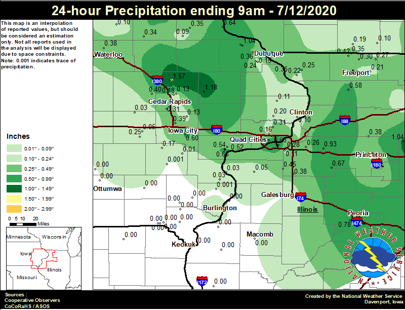
| Local Rainfall Analysis | Regional Rainfall Analysis |
 |
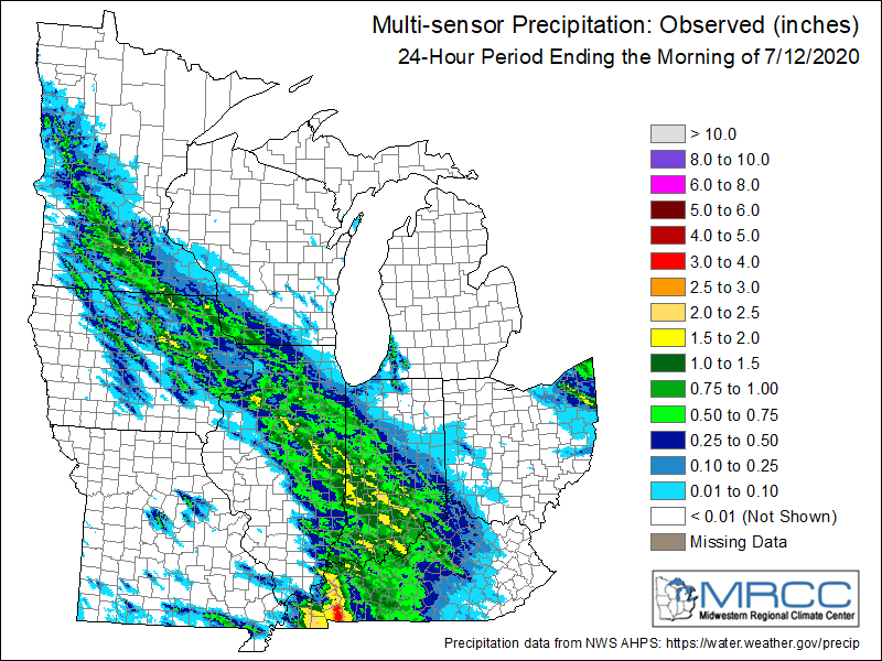 |
24 hour precipitation reports (in Inches),
for eastern Iowa, northwest and west central Illinois,
and northeast Missouri. Reported between Midnight and 9 AM,
Sunday July 12, 2020.

....IOWA....
Central City 6.7 W               1.57
Anamosa 3 SSW                    1.18
Rickardsville 0.2 W              1.04
Davenport 0.9 WNW                0.66
Muscatine 1.4 N                  0.65
Mason City 1 NNE                 0.65
Guttenberg Dam 10                0.64
Fayette 1 NW                     0.62
Iowa City                        0.60
Muscatine 2.1 N                  0.54
NWS Johnston* 5 NNW              0.42
Shellsburg 2.9 S                 0.40
North Liberty 0.7 SSW            0.39
Iowa City Arpt                   0.39
Waterloo ASOS 5 NW               0.38
Muscatine 2N                     0.36
Bellevue LD12                    0.36
Asbury 0.4 SW                    0.36
Elkader 6SSW                     0.35
Oelwein AWOS                     0.34
Cedar Rapids Arpt 5 SW           0.31
Park View 0.2 WSW                0.31
Parnell 0.1 SSW                  0.25
Boone 1 SSW                      0.24
Dubuque #3 7 SW                  0.24
De Witt                          0.20
Cedar Rapids 5.2 NNE             0.18
Wellman 4.0 E                    0.17
Davenport Arpt                   0.16
Dubuque Arpt                     0.15
Marion 1.7 NNW                   0.13
Solon 0.3 ESE                    0.13
Charlotte 1.9 WNW                0.11
Camanche 1.2 W                   0.10
Tripoli 0 N                      0.10
Mason City ASOS 6 W              0.09
Strawberry Point                 0.09
Hampton 1 N                      0.06
Williamsburg                     0.05
Ames US 30 2 SSE                 0.03
Wapello 5.4 SE                   0.03
Marengo 3.6 N                    0.03
Burlington Arpt 2 SW             0.02
Ainsworth 7.4 N                  0.01
Newton 1 NE                      0.01
Washington                       0.00
Perry 0 W                        0.00
Mediapolis 0.2 WNW               0.00
Farmington 0.4 NNW               0.00
Farmington 3.5 W                 0.00
Beaconsfield 1 NNE               0.00
Oskaloosa AWOS 9 ESE             0.00
Farmington 0.3 NW                0.00
Farmington 2.4 W                 0.00
West Point 7.5 NW                0.00
New London 1.5 SW                0.00
Centerville 0 NE                 0.00
Ottumwa ASOS 6 NNW               0.00
Pella AWOS 2 WSW                 0.00
Marshalltown 1 NW                0.00
Donnellson                       0.00
Keokuk LD19                      0.00
Fairfield                        0.00
Grinnell AWOS 2 SSW              0.00
Marshalltown ASOS 4 N            0.00
Salem 3.1 ESE                    0.00

....ILLINOIS....
Ottawa 4 SW                      1.50
Mendota 2 SE                     1.04
St Anne                          0.95
Atkinson 2.6 NNE                 0.93
Moline 0.7 NNE                   0.83
Bloomington Airport              0.80
Peoria ASOS                      0.78
Joliet                           0.75
Kewanee 1 E                      0.67
Lincoln NWS                      0.64
Steward                          0.62
Lanark 6.0 E                     0.58
Ill. City LD16 3 WNW             0.52
New Windsor 2.0 N                0.45
Winslow 4.3 ESE                  0.42
Freeport 2.9 WSW                 0.39
Walnut 5.3 ENE                   0.38
Woodhull 0.3 ESE                 0.38
Freeport 2.0 NW                  0.36
Freeport 1.7 NW                  0.35
Orangeville 2.8 NW               0.35
Rockford ASOS                    0.34
Dakota 4.8 NW                    0.30
Coal Valley 2.6 E                0.28
Davis 0.5 N                      0.27
Geneseo 2.0 NW                   0.26
Elizabeth                        0.25
Streator 3 SE                    0.24
Romeoville                       0.22
Hanover 0.2 NW                   0.22
Ridott 0.1 NE                    0.21
Freeport                         0.21
Princeton 1.1 SE                 0.20
Princeton                        0.20
Roscoe 2SE                       0.17
Coal Valley 1.9 SE               0.11
Rochelle AWOS                    0.10
Aledo                            0.05
New Boston LD17                  0.03
Mundelein                        0.00
Bentley                          0.00
Jacksonville AWOS                0.00
Gladstone LD18                   0.00
Colchester 3.5 NE                0.00
Dallas City 3.0 SSE              0.00
Quincy ASOS                      0.00
Galesburg Arpt 3 SW              0.00

....MISSOURI....
Columbia                         0.00
Memphis                          0.00
Chillicothe 2 NW                 0.00
Kirksville ASOS                  0.00

....WISCONSIN....
Whitewater                       0.75
Beloit-College                   0.28
Monroe 1 W                       0.19
Viroqua                          0.13
Brodhead 1 SW                    0.10
Watertown-AWOS                   0.03
La Crosse WFO                    0.00
Allenton-WWTP .6 NW              0.00
Madison-ASOS                     0.00

....MINNESOTA....
Theilman 1SSW                    0.00
Environment
SPC EVENT REVIEW PAGE: 07/11/2020
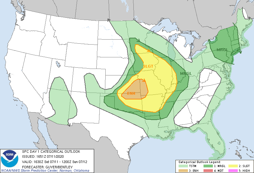
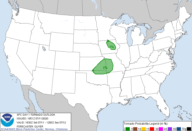
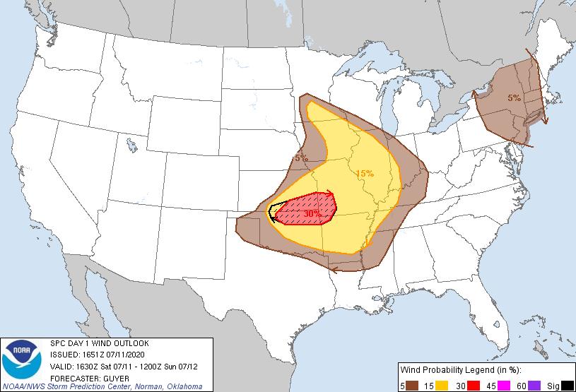
SPC Categorical/Tornado/Hail/Wind Outlooks
 |
 |
 |
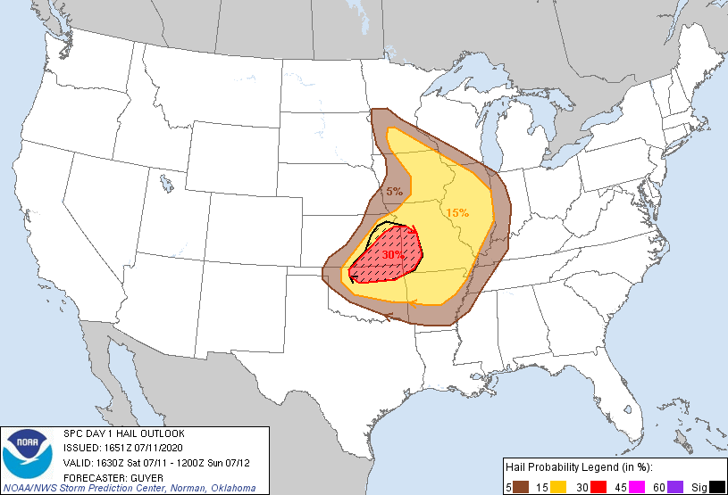 |
| SPC Categorical Outlook | Tornado Outlook | Wind Outlook | Hail Outlook |
Notable Analysis From The Area
 |
 |
 |
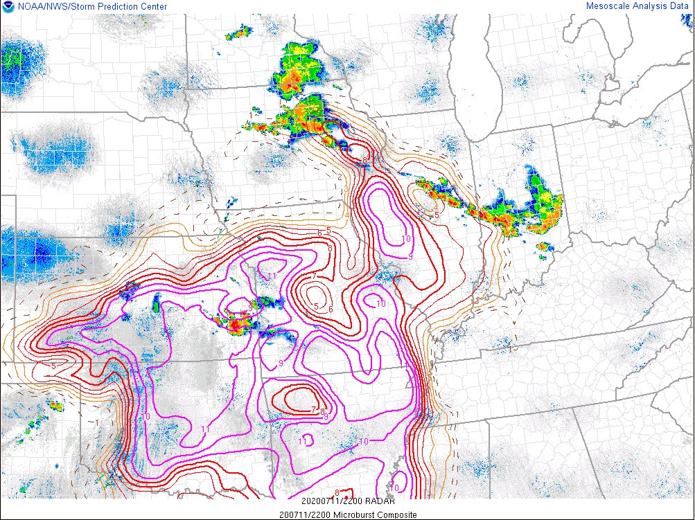 |
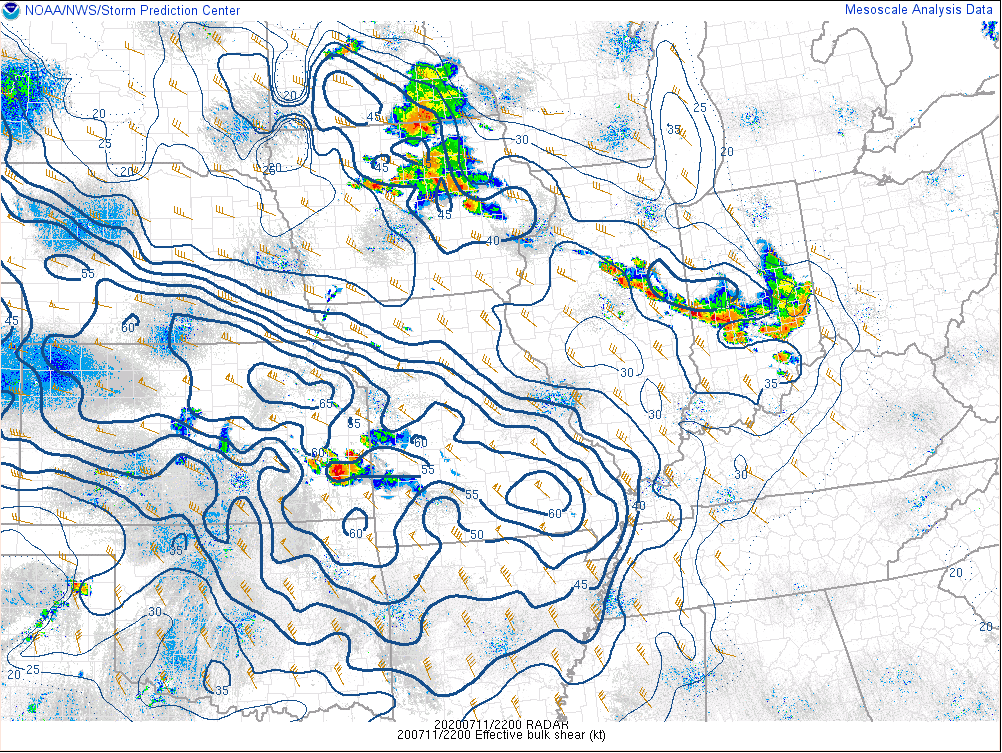
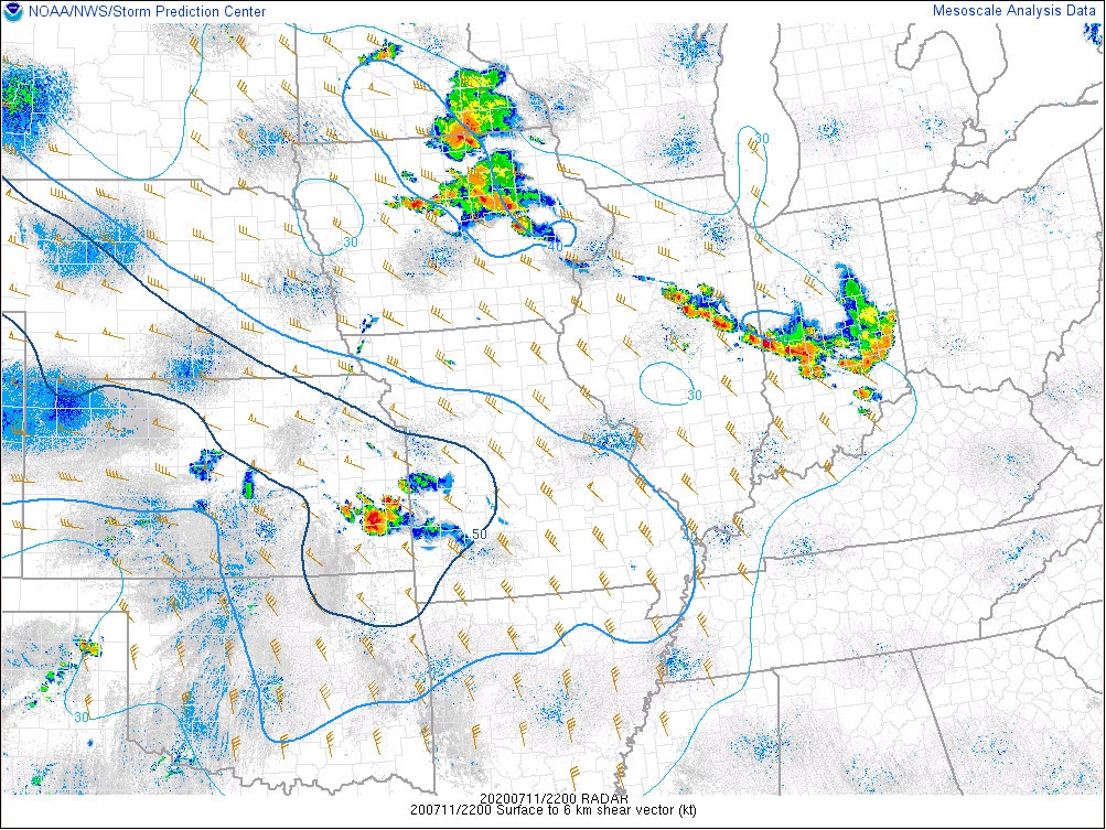
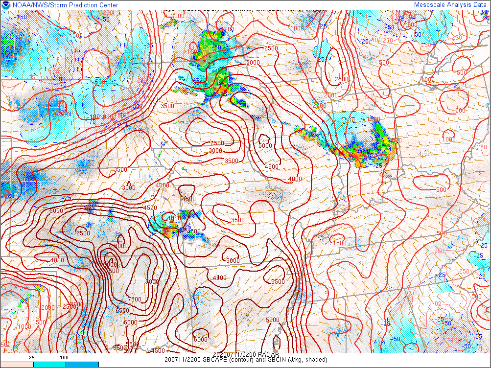
| Analyzed Effective Bulk Shear (SPC) | 0-6 km Wind Shear (SPC) | Surface Based Convective Available Potential Energy (SPC) | Microburst Composite (SPC) |
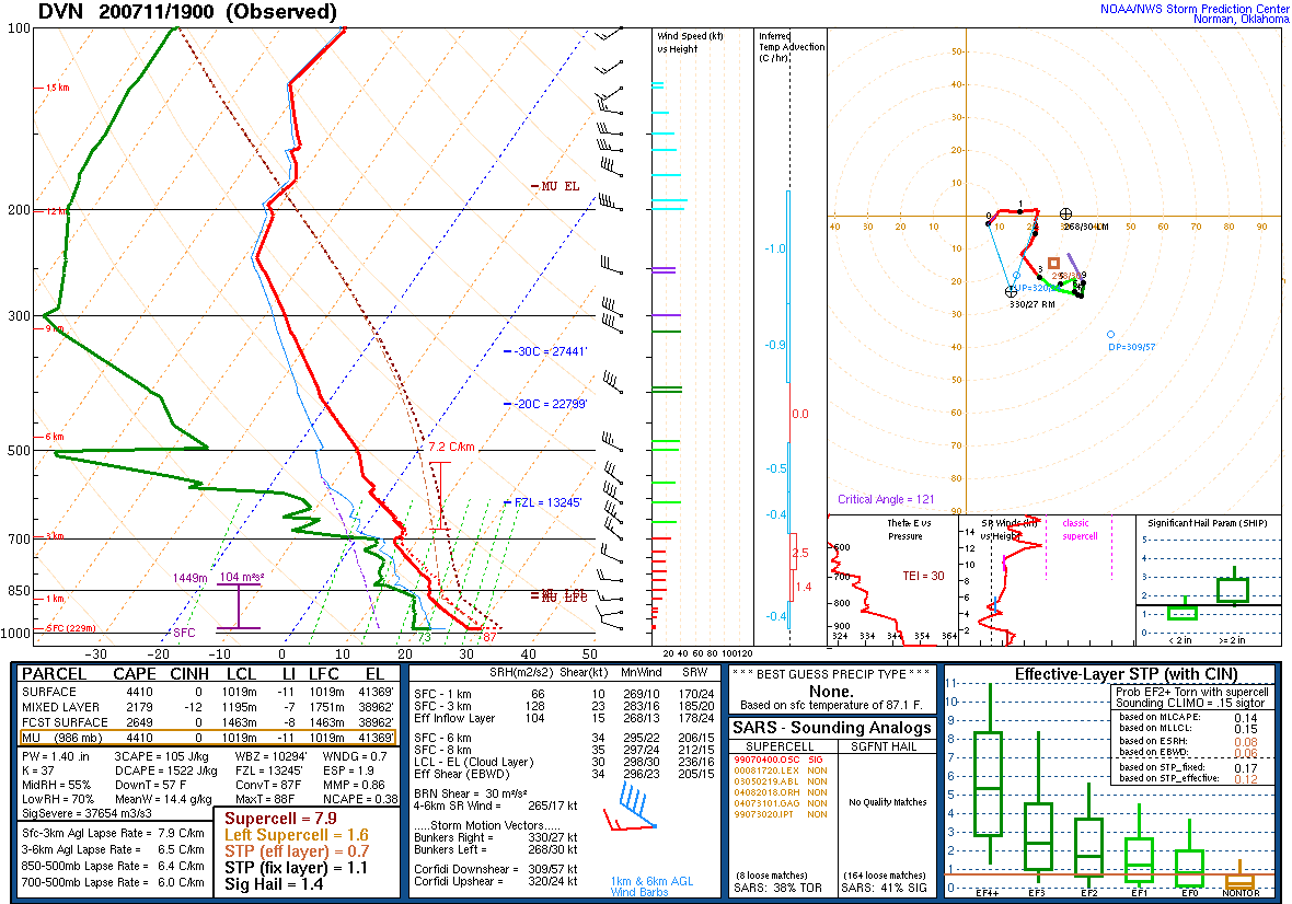
DVN Observed Sounding Analysis
 |
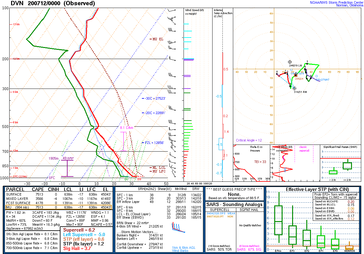 |
| 2 PM DAVENPORT, IA SOUNDING | 7 PM DAVENPORT, IA SOUNDING |
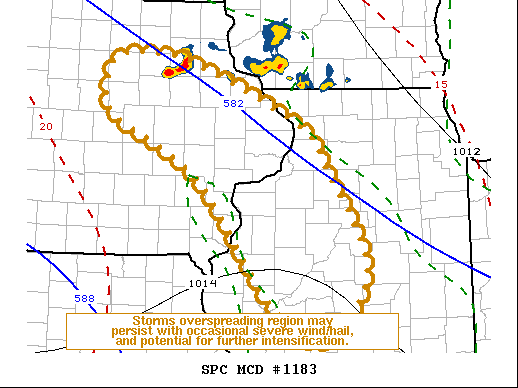
SPC Mesoscale Discussions
 |
 |
 |
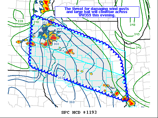 |
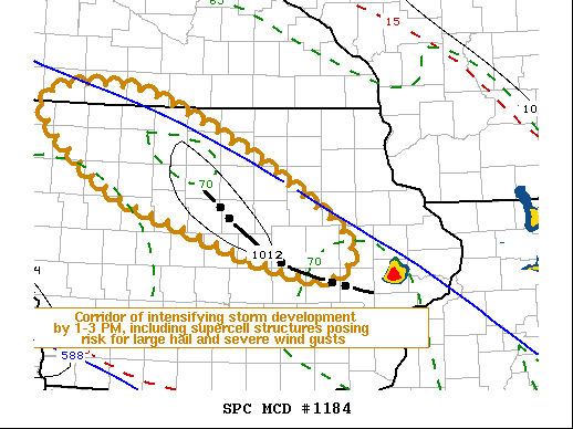
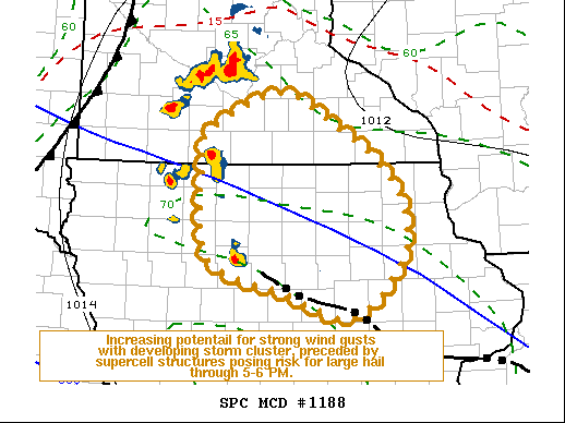
| Mesoscale Discussion #1183 | Mesoscale Discussion #1184 | Mesoscale Discussion #1188 | Mesoscale Discussion #1193 |
SPC Convective Watches
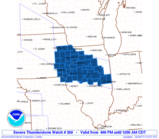 |
| Severe Thunderstorm Watch #359 |
 |
Media use of NWS Web News Stories is encouraged! Please acknowledge the NWS as the source of any news information accessed from this site. |
|

