Overview
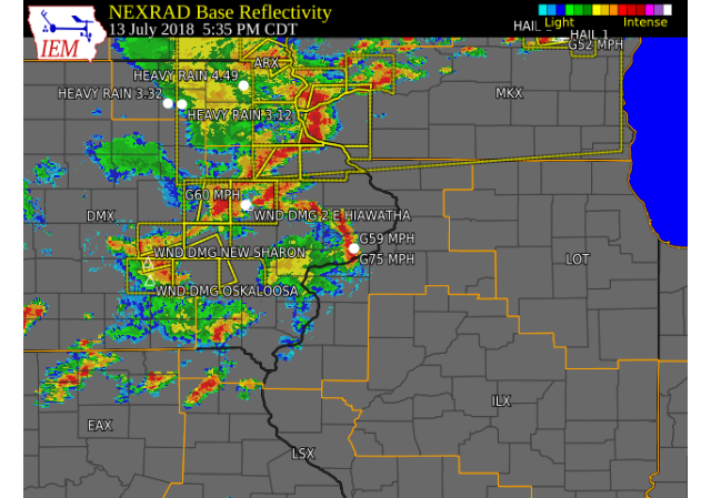
| Scattered showers and thunderstorms developed and tracked over portions of eastern Iowa, northwest Illinois, and northeast Missouri Friday afternoon and evening. These storms produced torrential rainfall for some, lightning, and damaging winds in a few counties. The highway 20 corridor from Dubuque to Freeport received the most wind damage and lightning. The town of Elizabeth Illinois in Jo Daviess county was particularly hit hard with damaging winds. A 75 mph wind gust was also recorded at the NWS Quad Cities forecast office with this evening's storms, snapping a few tree branches next to the office. | 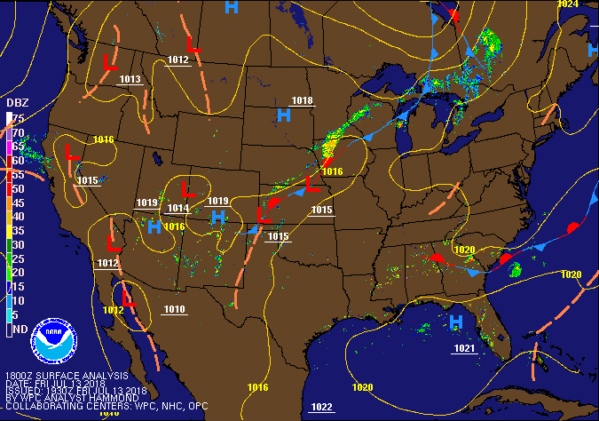 Weather Prediction Center Pressure / Fronts |
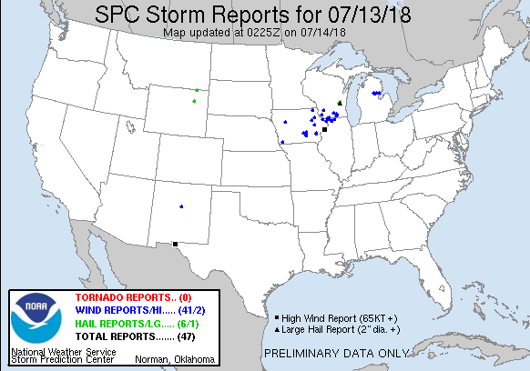
Storm Reports
| Interactive Storm Map | SPC Storm Reports |
 |
 |
PRELIMINARY LOCAL STORM REPORT...SUMMARY
NATIONAL WEATHER SERVICE QUAD CITIES IA IL
1231 PM CDT SAT JUL 14 2018

..TIME...   ...EVENT...      ...CITY LOCATION...     ...LAT.LON...
..DATE...   ....MAG....      ..COUNTY LOCATION..ST.. ...SOURCE....
            ..REMARKS..

0948 AM     HEAVY RAIN       1 NW DUBUQUE            42.52N 90.70W
07/14/2018  M1.32 INCH       DUBUQUE            IA   TRAINED SPOTTER

            12 HOUR TOTAL.

0819 AM     HEAVY RAIN       LE CLAIRE               41.60N 90.36W
07/14/2018  M2.50 INCH       SCOTT              IA   TRAINED SPOTTER


0819 AM     HEAVY RAIN       COLUMBUS JUNCTION       41.28N 91.37W
07/14/2018  M2.00 INCH       LOUISA             IA   TRAINED SPOTTER


0730 AM     HEAVY RAIN       GENESEO                 41.45N 90.15W
07/14/2018  E2.18 INCH       HENRY              IL   TRAINED SPOTTER

            TOTAL SINCE 745 PM LAST NIGHT.

0659 AM     HEAVY RAIN       2 NNE CEDAR RAPIDS      42.01N 91.66W
07/14/2018  M1.00 INCH       LINN               IA   TRAINED SPOTTER


0651 AM     HEAVY RAIN       ANNAWAN                 41.40N 89.91W
07/14/2018  E1.10 INCH       HENRY              IL   PUBLIC


0504 AM     HEAVY RAIN       1 NNW MONTICELLO        42.25N 91.20W
07/14/2018  M3.50 INCH       JONES              IA   TRAINED SPOTTER

            2.00 INCHES FELL IN 2.5 HOURS.

0835 PM     HEAVY RAIN       1 E GREEN RIVER         41.47N 90.32W
07/13/2018  E1.00 INCH       HENRY              IL   TRAINED SPOTTER

            RAIN FELL IN PAST 40 MIN.

0720 PM     TSTM WND DMG     1 N FREEPORT            42.30N 89.64W
07/13/2018                   STEPHENSON         IL   TRAINED SPOTTER

            2 INCH TREE BRANCHES BROKEN DOWN.

0718 PM     TSTM WND DMG     1 ENE FREEPORT          42.29N 89.62W
07/13/2018                   STEPHENSON         IL   EMERGENCY MNGR

            NUMEROUS TREES AND POWER LINES DOWN WITHIN
            TOWN.

0712 PM     TSTM WND DMG     4 NE NORA               42.50N 89.90W
07/13/2018                   STEPHENSON         IL   TRAINED SPOTTER

            SHINGLES BLOWN OFF BUILDINGS AND ESTIMATED
            55+ MPH WINDS.

0701 PM     TSTM WND GST     1 NE NORA               42.46N 89.93W
07/13/2018  E65 MPH          JO DAVIESS         IL   TRAINED SPOTTER

            2 INCH TREE BRANCHES BROKEN.

0700 PM     TSTM WND DMG     1 ESE NORA              42.46N 89.94W
07/13/2018                   JO DAVIESS         IL   TRAINED SPOTTER

            CORN FLATTENED AND A 10" DIAMETER TREE
            SPLIT.

0658 PM     TSTM WND DMG     STOCKTON                42.35N 90.01W
07/13/2018                   JO DAVIESS         IL   TRAINED SPOTTER

            1-2" DIAMETER TREE BRANCHES DOWN. DELAYED
            REPORT.

0640 PM     TSTM WND DMG     ELIZABETH               42.32N 90.22W
07/13/2018                   JO DAVIESS         IL   LAW ENFORCEMENT

            WINDOWS BLOWN OUT AND DECK SEVERELY DAMAGED
            ON A HOUSE.

0640 PM     TSTM WND DMG     ELIZABETH               42.32N 90.22W
07/13/2018                   JO DAVIESS         IL   TRAINED SPOTTER

            MATURE PINE TREES UPROOTED. SHINGLES BLOWN
            OFF CHURCH. DELAYED REPORT.

0637 PM     HAIL             2 SW SAINT DONATUS      42.35N 90.57W
07/13/2018  E0.50 INCH       JACKSON            IA   TRAINED SPOTTER


0630 PM     TSTM WND DMG     1 W SAINT DONATUS       42.35N 90.57W
07/13/2018                   JACKSON            IA   TRAINED SPOTTER

            ONE FOOT DIAMETER MAPLE TREE SNAPPED AND
            BLOWN OVER 1 MILE WEST OF SAINT DONATUS.
            DELAYED REPORT.

0625 PM     TSTM WND GST     1 ESE DUBUQUE           42.50N 90.66W
07/13/2018  E65 MPH          DUBUQUE            IA   TRAINED SPOTTER

            LARGE LIMBS DOWN.

0623 PM     HEAVY RAIN       1 NNW MONTICELLO        42.25N 91.20W
07/13/2018  E2.00 INCH       JONES              IA   TRAINED SPOTTER

            RAIN FELL IN 30 MIN.

0617 PM     TSTM WND DMG     2 ESE CLINTON           41.84N 90.20W
07/13/2018                   CLINTON            IA   TRAINED SPOTTER

            4 TO 8 INCH LIMBS DOWN.

0600 PM     HAIL             DYERSVILLE              42.48N 91.12W
07/13/2018  M0.25 INCH       DUBUQUE            IA   EMERGENCY MNGR


0600 PM     TSTM WND GST     DYERSVILLE              42.48N 91.12W
07/13/2018  M50 MPH          DUBUQUE            IA   EMERGENCY MNGR


0548 PM     TSTM WND DMG     2 E HIAWATHA            42.05N 91.65W
07/13/2018                   LINN               IA   TRAINED SPOTTER

            LARGE TREE DOWN ACROSS STREET APPROX 1 FT IN
            DIAMETER WITH SEVERAL SMALLER BRANCHES DOWN
            AS WELL.

0544 PM     TSTM WND GST     HIAWATHA                42.05N 91.68W
07/13/2018  E60 MPH          LINN               IA   TRAINED SPOTTER


0538 PM     TSTM WND DMG     1 ESE ELDRIDGE          41.63N 90.56W
07/13/2018                   SCOTT              IA   TRAINED SPOTTER

            NUMEROUS TREE LIMBS DOWN.

0536 PM     TSTM WND GST     DAVENPORT ARPT          41.61N 90.59W
07/13/2018  M59 MPH          SCOTT              IA   ASOS

            ASOS STATION DVN, DAVENPORT ARPT.

0535 PM     TSTM WND GST     DAVENPORT MUNICIPAL AIR 41.61N 90.59W
07/13/2018  M75 MPH          SCOTT              IA   MESONET

            MEASURED ON DVN RSOIS SYSTEM.

0451 PM     TSTM WND GST     1 WNW INDEPENDENCE      42.48N 91.91W
07/13/2018  E60 MPH          BUCHANAN           IA   PUBLIC


0448 PM     TSTM WND GST     1 N INDEPENDENCE        42.49N 91.89W
07/13/2018  E50 MPH          BUCHANAN           IA   TRAINED SPOTTER


0416 PM     TSTM WND DMG     1 SSE CRANSTON          41.37N 91.26W
07/13/2018                   MUSCATINE          IA   PUBLIC

            VIA TWITTER. SMALL TREE LIMBS DOWN.

0407 PM     TSTM WND DMG     5 N HASKINS             41.40N 91.54W
07/13/2018                   WASHINGTON         IA   EMERGENCY MNGR

            ROOF BLOWN OFF A MACHINE SHED.

0400 PM     TSTM WND DMG     2 SSW GLADWIN           41.35N 91.47W
07/13/2018                   LOUISA             IA   TRAINED SPOTTER

            2 TO 3 INCH BRANCHES DOWN WITH REALLY STRONG
            WIND.

0354 PM     TSTM WND DMG     AINSWORTH               41.29N 91.54W
07/13/2018                   WASHINGTON         IA   TRAINED SPOTTER

            TREE LIMBS IN ROAD WITH STRONG WIND.
Rain Reports
 |
 |
|
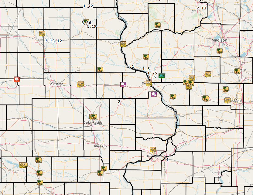
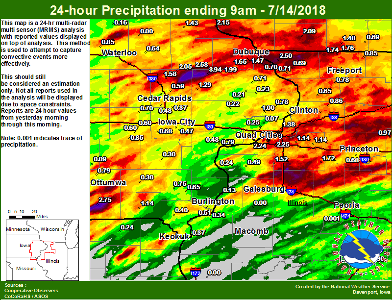
| Figure 1: Local 24-hr Rainfall ending 9 am 7/14 |
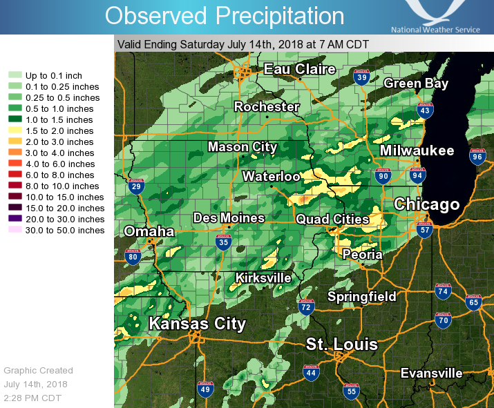
Figure 2: Regional Rainfall Ending 7am 7/14 |
) |
....IOWA....
Monticello 1 E                   3.94
Bloomfield 1 NW                  2.75
Hopkinton 5.4 WSW                2.58
Bettendorf 2.2 SE                2.29
Guttenberg Dam 10                2.15
Coggon                           2.05
Cascade                          1.99
Dubuque LD11                     1.96
Davenport 0.9 SSW                1.87
Cresco 1 NE                      1.78
Peosta 2.9 E                     1.65
Central City 6.7 W               1.58
Dubuque #3 7 SW                  1.54
Bettendorf 1.6 WSW               1.48
Dubuque Arpt 7 SW                1.47
Elkader 6SSW                     1.43
Le Claire 1.8 NNE                1.38
Anamosa 3 SSW                    1.29
Keosauqua                        1.14
Davenport 0.9 WNW                1.13
Rathbun Reservoir 2 N            1.03
Cedar Rapids 2.7 NE              1.00
De Witt                          1.00
Camanche 1.2 W                   0.88
North English                    0.85
Waterloo ASOS 5 NW               0.85
Mason City ASOS 6 W              0.82
Mason City 1 NNE                 0.80
Ottumwa ASOS 6 NNW               0.79
Goose Lake 6.4 SSW               0.78
Burlington Arpt 2 SW             0.75
Mt Pleasant 1 SSW                0.75
Newton 1 NE                      0.74
Fulton                           0.71
Bellevue LD12                    0.70
Amana 4.7 W                      0.70
Kalona 7.3 NNW                   0.68
Toledo 3 N                       0.67
Marshalltown 1 NW                0.67
New London 1.5 SW                0.65
Independence 1.2 N               0.64
Parnell 0.1 SSW                  0.60
Williamsburg                     0.60
Marion 1.7 NNW                   0.59
Burlington 6.5 SSW               0.51
Muscatine 2.6 NNE                0.48
Cedar Rapids Arpt 5 SW           0.48
Iowa City Arpt                   0.48
Hampton 1 N                      0.48
Iowa City                        0.47
Davenport Arpt 5 N               0.46
Maquoketa 4W                     0.41
Ames US 30 2 SSE                 0.40
Beaconsfield 1 NNE               0.40
Donnellson                       0.40
Cedar Rapids 3.4 NW              0.39
Ely 0.5 SE                       0.37
Keokuk LD19                      0.37
Eldridge 0.6 S                   0.31
Washington                       0.30
Fairfield                        0.30
Muscatine 2N                     0.29
Brighton                         0.27
Boone 1 SSW                      0.26
Eldridge 0.7 SSW                 0.25
Marshalltown ASOS 4 N            0.24
Delmar 2.3 NW                    0.23
Lowden                           0.22
Lost Nation 0.3 S                0.21
Grinnell 2 SW                    0.19
Pella AWOS 2 WSW                 0.18
Grinnell AWOS 2 SSW              0.17
Tripoli 0 N                      0.16
NWS Johnston* 5 NNW              0.14
Oskaloosa AWOS 9 ESE             0.09
Park View 0.2 WSW                0.07
Perry 0 W                        0.04
Oelwein AWOS                     0.00
....ILLINOIS....
Quad City Arpt 3 S               2.74
Moline 0.9 N                     2.66
Galena                           2.50
Moline 0.7 NNE                   2.26
Coal Valley 1.9 SE               2.25
Moline 1.0 WNW                   2.24
Rochelle                         1.90
Orangeville 2.8 NW               1.76
Winslow 4.3 ESE                  1.74
Kewanee 1 E                      1.72
Morrison 3.2 E                   1.62
Paw Paw 1 E                      1.52
New Windsor 2.0 N                1.52
Geneseo 2.0 NW                   1.14
Atkinson 2.6 NNE                 1.14
Mendota 2 SE                     0.97
Coleta 1.4 SSW                   0.86
Davis 0.5 N                      0.85
Pearl City 0.4 SW                0.84
Ill. City LD16 3 WNW             0.79
Shannon 0.2 S                    0.78
Hanover 0.2 NW                   0.71
Elizabeth                        0.69
Princeton 1.1 SE                 0.68
Princeton                        0.68
Tiskilwa 2.1 N                   0.68
Chadwick 2.7 WSW                 0.65
Roscoe 2SE                       0.62
Freeport                         0.56
Freeport 2.0 NW                  0.53
Galesburg Arpt 3 SW              0.50
Aledo                            0.49
Rockford ASOS                    0.48
Dallas City 3.0 SSE              0.34
New Boston LD17                  0.24
Mundelein                        0.15
Gladstone LD18                   0.13
Joliet                           0.06
Romeoville                       0.02
Peoria ASOS                      0.00
Decatur Airport                  0.00
Jacksonville AWOS                0.00
Rochelle AWOS                    0.00
Colchester 3.5 NE                0.00
Quincy ASOS                      0.00
Macomb                           0.00
St Anne                          0.00
Bloomington Airport              0.00
Roseville 0.6 WNW                0.00
Lincoln NWS                      0.00
....MISSOURI....
Memphis                          0.24
Chillicothe 2 NW                 0.22
Columbia                         0.07
Kirksville ASOS                  0.00
....WISCONSIN....
Darlington                       2.09
Monroe 1 W                       1.48
Prairie du Chien AWOS            1.14
Madison-ASOS                     1.13
La Crosse WFO                    1.04
Steuben 4SE 3 NE                 0.92
Brodhead 1 SW                    0.69
Allenton-WWTP .6 NW              0.55
Beloit-College                   0.42
Whitewater                       0.38
Delavan-1 W-WWTP 1 W             0.33
Viroqua                          0.31
Watertown-AWOS                   0.13
 |
Media use of NWS Web News Stories is encouraged! Please acknowledge the NWS as the source of any news information accessed from this site. |
|