Dangerous heat will expand from the Gulf Coast into the Southern Plains and Desert Southwest through week's end. Additional extreme heat impacting the Pacific Northwest will shift to the northern Plains by the weekend. Tropical Storm Bertha is expected to continue to impact portions of the northern Gulf Coast from the western Florida Panhandle to southeastern Louisiana through tonight. Read More >
Event Summary: July 17, 2019
|
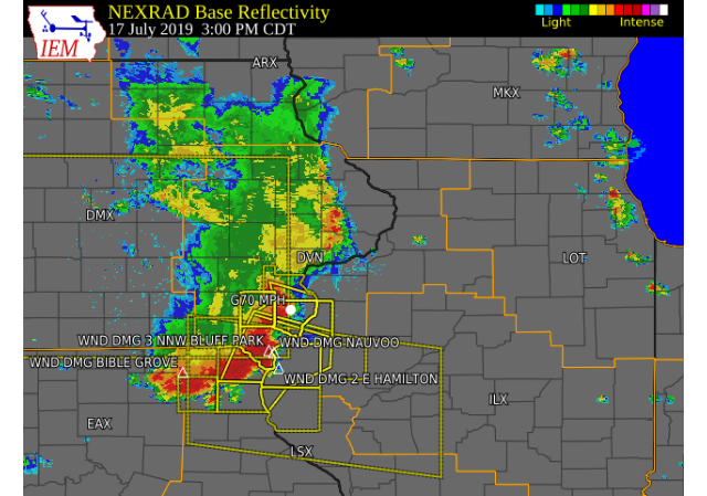
A large complex of showers and thunderstorms progressed across southeast Iowa, west central Illinois and northeast Missouri this afternoon. Storms became severe as they moved southeast, and produced damaging wind gusts up to 70 MPH at times. These winds caused damage to roofs, carports, sidings and uprooted several trees in Stockport, Wayland and Burlington. In addition, torrential rainfall amounts of 1-2 inches were reported, and led to brief flash flooding in Keokuk.
|
|
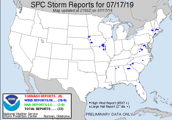
Storm Reports
| SPC Storm Reports |
 |
| IEM MESONET STORM REPORTS |
PRELIMINARY LOCAL STORM REPORT...SUMMARY
NATIONAL WEATHER SERVICE QUAD CITIES IA IL
WED JUL 17 2019


..TIME...   ...EVENT...      ...CITY LOCATION...     ...LAT.LON...
..DATE...   ....MAG....      ..COUNTY LOCATION..ST.. ...SOURCE....
            ..REMARKS..

0434 PM     TSTM WND DMG     2 NNE BUSHNELL          40.57N 90.49W
07/17/2019                   MCDONOUGH          IL   911 CALL CENTER

            TREE DOWN NORTH OF TOWN NEAR 41 AND THE
            RAILROAD TRACKS.

0420 PM     TSTM WND GST     1 SE MACOMB             40.46N 90.67W
07/17/2019  M60 MPH          MCDONOUGH          IL   TRAINED SPOTTER


0404 PM     TSTM WND GST     1 S MACOMB              40.45N 90.69W
07/17/2019  E60 MPH          MCDONOUGH          IL   PUBLIC

            DELAYED REPORT AND TIME ESTIMATED FROM
            RADAR. CORN FLATTENED IN A FIELD.


0359 PM     TSTM WND DMG     1 SSW SCIOTA            40.55N 90.76W
07/17/2019                   MCDONOUGH          IL   PUBLIC

            DELAYED REPORT WITH TIME ESTIMATED FROM
            RADAR. 2 20 INCH PLUS DIAMETER TREES DOWN.
            CORN FLATTENED ON THE SOUTH SIDE OF STATE
            ROUTE 9 AND CONTINUING BROADLY SOUTH FOR
            MILES.


0343 PM     TSTM WND GST     1 S BURLINGTON REGIONAL 40.77N 91.13W
07/17/2019  M57 MPH          DES MOINES         IA   ASOS


0340 PM     HEAVY RAIN       CANTRIL                 40.64N 92.07W
07/17/2019  M1.00 INCH       VAN BUREN          IA   TRAINED SPOTTER

            RAINFALL TOTAL OVER THE PAST HOUR.

0340 PM     FLASH FLOOD      1 ESE KEOKUK            40.40N 91.39W
07/17/2019                   LEE                IA   TRAINED SPOTTER

            2.00 INCHES OF RAIN FELL WITH PASSING STORMS
            WHICH CAUSED ISOLATED FLASH FLOODING IN
            KEOKUK. AN INTERSECTION THAT TYPICALLY
            FLOODS HAD WATER COME UP WELL DEEPER THAN
            NORMAL, TO APPROXIMATELY 4 FT DEEP WHICH
            APPEARED TO BE UP A COUPLE OF FEET ONTO THE
            DOORS OF A FEW BUSINESSES. WATER HAD RECEDED
            AT TIME OF REPORT.

0330 PM     HEAVY RAIN       3 W MOUNT STERLING      40.62N 92.00W
07/17/2019  M1.20 INCH       VAN BUREN          IA   TRAINED SPOTTER

            RAINFALL TOTAL SINCE 215 PM. RAIN BEGINNING
            TO END.

0318 PM     HAIL             KEOKUK                  40.41N 91.39W
07/17/2019  E0.88 INCH       LEE                IA   TRAINED SPOTTER
0307 PM     TSTM WND DMG     NAUVOO                  40.55N 91.38W
07/17/2019                   HANCOCK            IL   PUBLIC

            DELAYED REPORT. TIME ESTIMATED FROM RADAR.
            NUMEROUS TREES AND POWER LINES DOWN IN
            NAUVOO. MOBILE HOME DESTROYED.
0305 PM     TSTM WND GST     3 SW MEDIAPOLIS         40.98N 91.21W
07/17/2019  E70 MPH          DES MOINES         IA   TRAINED SPOTTER

            NO DAMAGE, OBSERVED IN AN OPEN AREA.

0305 PM     TSTM WND DMG     2 E HAMILTON            40.39N 91.33W
07/17/2019                   HANCOCK            IL   TRAINED SPOTTER

            2-INCH TREES DOWN IN SEVERAL SPOTS NEARBY.

0300 PM     TSTM WND DMG     3 NNW BLUFF PARK        40.57N 91.43W
07/17/2019                   LEE                IA   PUBLIC

            ROOF DAMAGE TO THE GREGORY MANUFACTURING CO
            NORTH OF MONTROSE. PICTURE RECEIVED VIA
            SOCIAL MEDIA. TIME ESTIMATED FROM RADAR.

0255 PM     TSTM WND DMG     BIBLE GROVE             40.35N 92.30W
07/17/2019                   SCOTLAND           MO   LAW ENFORCEMENT

            DELAYED REPORT. SEVERAL TREES DOWN IN
            ROADWAYS IN BIBLE GROVE PER SHERIFFS OFFICE.

0242 PM     TSTM WND DMG     MOUNT UNION             41.06N 91.39W
07/17/2019                   HENRY              IA   TRAINED SPOTTER

            LARGE, 14-INCH TREE LIMB FELL ON HOUSE.
            DEBRIS LIKE GARBAGE CANS FLYING AROUND.

0240 PM     TSTM WND DMG     1 WSW MT HAMILL         40.74N 91.64W
07/17/2019                   LEE                IA   TRAINED SPOTTER

            TOOL SHED ROOF BLOWN OFF. WIND ESTIMATE WAS
            60-70 MPH. TIME ESTIMATED FROM RADAR.

0225 PM     TSTM WND DMG     STOCKPORT               40.86N 91.83W
07/17/2019                   VAN BUREN          IA   TRAINED SPOTTER

            SEVERAL LARGE TREES UPROOTED OR SPLIT IN
            HALF, AROUND 15-18 INCHES IN DIAMETER.
            SEVERAL CARPORTS ALSO DAMAGED.

0225 PM     TSTM WND DMG     3 W HILLSBORO           40.84N 91.77W
07/17/2019                   VAN BUREN          IA   TRAINED SPOTTER

            POWER POLES DOWN IN THE AREA AND NO POWER AT
            THE RESIDENCE. FOUR INCH DIAMETER TREE
            BRANCHES BROKEN AND CORN WAS BLOWN DOWN.

0215 PM     TSTM WND GST     4 SSW WASHINGTON AIRPOR 41.23N 91.69W
07/17/2019  E55 MPH          WASHINGTON         IA   TRAINED SPOTTER

            NO DAMAGE.

0215 PM     TSTM WND GST     WASHINGTON AIRPORT      41.27N 91.67W
07/17/2019  M55 MPH          WASHINGTON         IA   AWOS

            AWOS STATION KAWG WASHINGTON ARPT.

0212 PM     TSTM WND DMG     WAYLAND                 41.15N 91.66W
07/17/2019                   HENRY              IA   FIRE DEPT/RESCUE

            WAYLAND FIRE CHIEF REPORTS THAT NUMEROUS
            TREES WERE DOWN IN WAYLAND. A FEW STRUCTURES
            HAD THEIR ROOFS RIPPED OFF AND A HORSE BARN
            WAS DESTROYED IN THE AREA.
1000 AM     HEAVY RAIN       1 E LA HARPE            40.58N 90.96W
07/18/2019  M2.50 INCH       HANCOCK            IL   COCORAHS

            COCORAHS STATION IL-HN-7 LA HARPE 0.7 E.

0811 AM     HEAVY RAIN       1 SSE BURLINGTON        40.80N 91.11W
07/18/2019  M1.79 INCH       DES MOINES         IA   COCORAHS

            COCORAHS STATION IA-DM-8 BURLINGTON 0.8 SSE.

0800 AM     HEAVY RAIN       1 N CENTER GROVE        42.50N 90.72W
07/18/2019  M1.45 INCH       DUBUQUE            IA   COCORAHS

            COCORAHS STATION IA-DB-19 DUBUQUE 1.4 WSW.

0730 AM     HEAVY RAIN       1 NNW EAST DUBUQUE      42.50N 90.64W
07/18/2019  M1.60 INCH       JO DAVIESS         IL   COCORAHS

            COCORAHS STATION IL-JD-9 EAST DUBUQUE 0.5
            NNW.

0700 AM     HEAVY RAIN       DONNELLSON              40.65N 91.56W
07/18/2019  M1.95 INCH       LEE                IA   CO-OP OBSERVER

            CO-OP OBSERVER STATION DNNI4 DONNELLSON.

0700 AM     HEAVY RAIN       1 NE MACOMB             40.48N 90.67W
07/18/2019  M1.58 INCH       MCDONOUGH          IL   CO-OP OBSERVER

            CO-OP OBSERVER STATION MQBI2 MACOMB.

0700 AM     HEAVY RAIN       1 ESE BURLINGTON REGION 40.78N 91.12W
07/18/2019  M1.57 INCH       DES MOINES         IA   COCORAHS

            COCORAHS STATION IA-DM-10 BURLINGTON 2.1 S.

0700 AM     HEAVY RAIN       1 NW ONECO              42.50N 89.68W
07/18/2019  M1.47 INCH       STEPHENSON         IL   COCORAHS

            COCORAHS STATION IL-SP-3 ORANGEVILLE 2.8 NW.

0700 AM     HEAVY RAIN       1 E CASCADE             42.30N 91.00W
07/18/2019  M1.28 INCH       DUBUQUE            IA   CO-OP OBSERVER

            CO-OP OBSERVER STATION CASI4 CASCADE.

0700 AM     HEAVY RAIN       3 W MACOMB              40.46N 90.75W
07/18/2019  M1.25 INCH       MCDONOUGH          IL   COCORAHS

            COCORAHS STATION IL-MCD-7 COLCHESTER 3.5 NE.

0700 AM     HEAVY RAIN       2 NW FREEPORT           42.31N 89.66W
07/18/2019  M1.09 INCH       STEPHENSON         IL   COCORAHS

            COCORAHS STATION IL-SP-6 FREEPORT 2.0 NW.

0700 AM     HEAVY RAIN       3 NNE STOCKTON          42.40N 89.99W
07/18/2019  M1.05 INCH       JO DAVIESS         IL   COCORAHS

            COCORAHS STATION IL-JD-8 STOCKTON 3.4 NNE.

0700 AM     HEAVY RAIN       2 WSW SPRING GROVE      40.73N 91.19W
07/18/2019  M1.01 INCH       DES MOINES         IA   COCORAHS

            COCORAHS STATION IA-DM-7 BURLINGTON 6.5 SSW.

0700 AM     HEAVY RAIN       3 NNE MC CONNELL        42.47N 89.72W
07/18/2019  M1.01 INCH       STEPHENSON         IL   COCORAHS

            COCORAHS STATION IL-SP-8 WINSLOW 4.3 ESE.

0600 AM     HEAVY RAIN       1 WSW MEMPHIS           40.46N 92.18W
07/18/2019  M1.35 INCH       SCOTLAND           MO   CO-OP OBSERVER

            CO-OP OBSERVER STATION MMPM7 MEMPHIS.

0600 AM     HEAVY RAIN       5 NNE BRIGHTON          41.24N 91.77W
07/18/2019  M1.32 INCH       WASHINGTON         IA   COCORAHS

            COCORAHS STATION IA-WS-8 WASHINGTON 5.8 SW.
|
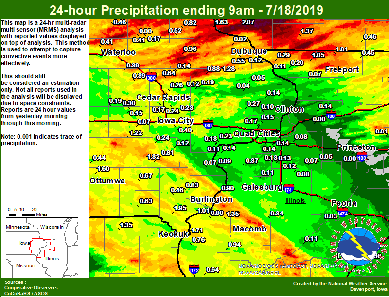
Area Rainfall Amounts
|
24-hr Local Rainfall Map |
 |
|
24 hour precipitation reports (in Inches), ....IOWA.... |
Environmental Analysis / Other Information
SPC Convective Outlooks
 |
 |
 |
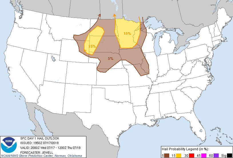 |
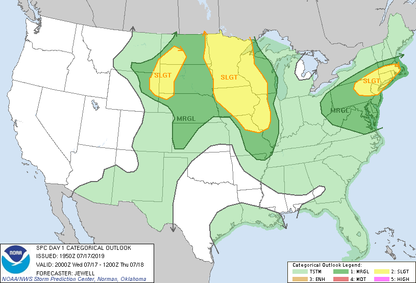
| SPC Day 1 Outlook (2000z) | SPC Day 1 Tornado Outlook (2000z) | SPC Day 1 Wind Outlook (2000z) | SPC Day 1 Hail Outlook (2000z) |
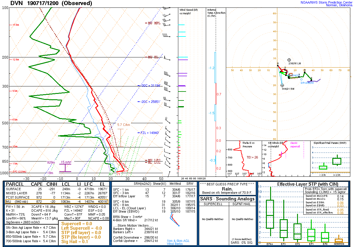
Local Sounding Analysis
 |
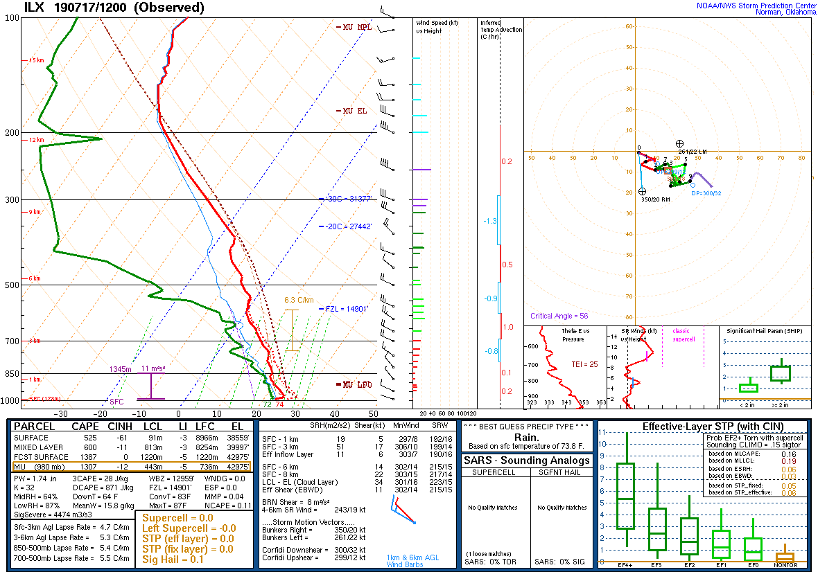 |
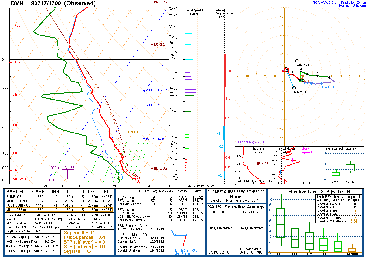 |
||
| DVN Sounding 7/17/19 12z | ILX Sounding 7/17/19 00z | DVN Sounding 7/17/19 17z |
SPC Watches Issued For Our Area
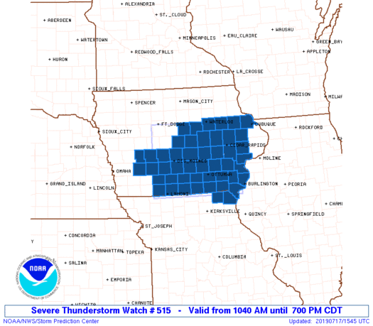 |
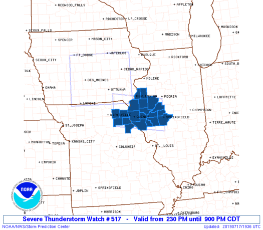 |
| SPC Severe Thunderstorm Watch #515 (see link for more details) | SPC Severe Thunderstorm Watch #517 (see link for more details) |
SPC Mesoscale Discussions Issued For Our Area
 |
 |
 |
||
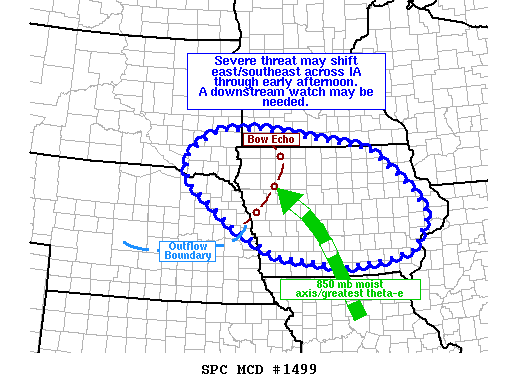
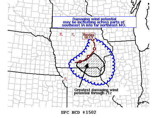
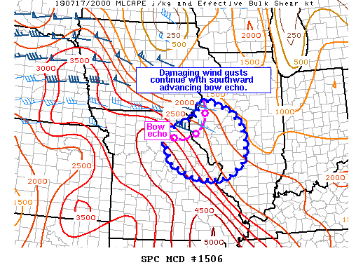
| SPC Mesoscale Discussion #1499 (see link for more details) | SPC Mesoscale Discussion #1502 (see link for more details) | SPC Mesoscale Discussion #1506 (see link for more details) |
SPC - Storm Prediction Center
 |
Media use of NWS Web News Stories is encouraged! Please acknowledge the NWS as the source of any news information accessed from this site. |
|