Event Summary: July 20, 2019
|
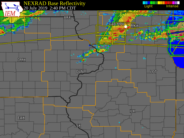
Several rounds of strong to severe thunderstorms impacted the region Saturday afternoon and evening. The first round came for the Highway 20 corridor during the early afternoon. These storms intensified around and east of Dubuque, where strong winds took down a few trees in Apple River Canyon State Park and damaged some roofs of homes in eastern Dubuque. The second round of severe thunderstorms came late in the afternoon and evening, and impacted areas along and southwest of a line from Sigourney to Burlington. Strong wind gusts lead to several reports of trees downing power lines across Van Buren and Keokuk counties. Additionally, rainfall amounts over one inch were reported in Jefferson and Van Buren counties.
|
|
Storm Reports
| SPC Storm Reports |
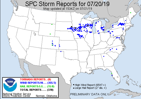 |
| IEM MESONET STORM REPORTS |
PRELIMINARY LOCAL STORM REPORT...SUMMARY
NATIONAL WEATHER SERVICE QUAD CITIES IA IL
1018 AM CDT SUN JUL 21 2019

..TIME...   ...EVENT...      ...CITY LOCATION...     ...LAT.LON...
..DATE...   ....MAG....      ..COUNTY LOCATION..ST.. ...SOURCE....
            ..REMARKS..

0255 PM     TSTM WND DMG     4 SSE APPLE RIVER       42.45N 90.05W
07/20/2019                   JO DAVIESS         IL   LAW ENFORCEMENT

            A COUPLE OF TREES DOWN AT THE APPLE RIVER
            CANYON STATE PARK. TIME ESTIMATED BY RADAR.

0755 PM     TSTM WND DMG     STOCKPORT               40.86N 91.83W
07/20/2019                   VAN BUREN          IA   LAW ENFORCEMENT

            TREE LIMBS ON POWER LINES. TREE LIMB ON
            FIRE. TIME ESTIMATED FROM RADAR.

0700 PM     TSTM WND DMG     HEDRICK                 41.18N 92.30W
07/20/2019                   KEOKUK             IA   LAW ENFORCEMENT

            TREE LIMBS DOWN TAKING OUT POWER LINES. TIME
            ESTIMATED FROM RADAR.

0655 PM     TSTM WND DMG     WHAT CHEER              41.40N 92.36W
07/20/2019                   KEOKUK             IA   LAW ENFORCEMENT

            TREE LIMBS DOWN TAKING OUT POWER LINES. TIME
            ESTIMATED FROM RADAR.
None |
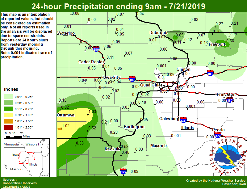
Area Rainfall Amounts
|
24-hr Local Rainfall Map |
 |
|
24 hour precipitation reports (in Inches), Sunday July 21, 2019.
....IOWA....
Allerton 2 S                     1.34
NWS Johnston* 5 NNW              1.25
Centerville 0 NE                 1.11
Beaconsfield 1 NNE               1.10
Fairfield                        1.03
Bloomfield 1 NW                  1.02
Ottumwa ASOS 6 NNW               0.82
Pella AWOS 2 WSW                 0.81
Rathbun Reservoir 2 N            0.70
Newton 1 NE                      0.53
Keokuk LD19                      0.52
Keosauqua                        0.52
Boone 1 SSW                      0.44
Hampton 1 N                      0.39
Grinnell AWOS 2 SSW              0.32
Ames US 30 2 SSE                 0.25
Donnellson                       0.23
Mason City 1 NNE                 0.22
Salem 1S                         0.21
Oskaloosa AWOS 9 ESE             0.15
Cedar Rapids 2.7 NE              0.11
Bellevue LD12                    0.11
Mason City ASOS 6 W              0.08
Tripoli 0 N                      0.08
Anamosa 3 SSW                    0.07
Dubuque LD11                     0.07
Elkader 6SSW                     0.07
Fulton                           0.06
Kalona 7.3 NNW                   0.06
Charlotte 1.9 WNW                0.06
Central City 6.7 W               0.05
Wapello 0.2 S                    0.05
Manchester                       0.05
Center Point 0.6 NNW             0.05
Mount Auburn 2.2 NNW             0.05
Iowa City Arpt                   0.05
Coggon                           0.05
Fayette 1 NW                     0.05
Amana 4.7 W                      0.05
Williamsburg                     0.05
Marshalltown ASOS 4 N            0.05
Solon 0.3 ESE                    0.05
Manchester 1.1 N                 0.04
Cedar Rapids Arpt 5 SW           0.04
Iowa City                        0.04
Wellman 4.0 E                    0.04
Marshalltown 1 NW                0.04
Parnell 0.1 SSW                  0.04
Guttenberg Dam 10                0.04
Morning Sun 1.7 E                0.03
Burlington 0.8 SSE               0.03
Toledo 3 N                       0.03
Muscatine 2N                     0.02
Washington                       0.02
Burlington Arpt 2 SW             0.02
Strawberry Point                 0.02
Ainsworth 7.4 N                  0.02
Dubuque Arpt 7 SW                0.01
Eldridge 0.7 SSW                 0.01
Asbury 0.4 SW                    0.01
Waterloo ASOS 5 NW               0.01
Dubuque #3 7 SW                  0.01
Davenport Arpt 5 N               0.00
Dubuque 1.4 WSW                  0.00
Calamus 2.0 NE                   0.00
Bettendorf 2.2 SE                0.00
Burlington 2.1 S                 0.00
Davenport 0.9 WNW                0.00
Camanche 1.2 W                   0.00
Park View 0.2 WSW                0.00
Oelwein AWOS                     0.00
Vinton                           0.00
Salem 3.1 ESE                    0.00
Davenport 0.9 SSW                0.00
....ILLINOIS....
Mundelein                        1.43
Roscoe 2SE                       0.82
Freeport                         0.75
Ridott 0.1 NE                    0.68
Galena                           0.65
Warsaw 5.8 SE                    0.48
Winslow 4.3 ESE                  0.36
Freeport 1.7 NW                  0.36
Freeport 2.0 NW                  0.35
Freeport 2.9 WSW                 0.18
Davis 0.5 N                      0.14
Pearl City 0.4 SW                0.13
Elizabeth                        0.12
New Boston LD17                  0.10
Quincy ASOS                      0.09
Stockton 3.4 NNE                 0.07
Gladstone LD18                   0.05
Bentley                          0.03
La Harpe                         0.03
Colchester 3.5 NE                0.02
Illinois City 6.7 SW             0.02
Rockford ASOS                    0.01
Macomb                           0.01
Ill. City LD16 3 WNW             0.01
Galesburg                        0.00
Moline 0.7 NNE                   0.00
Monmouth 0.5 NNW                 0.00
Prairie City 2S                  0.00
Altona                           0.00
Geneseo 2.0 NW                   0.00
Aledo                            0.00
Windsor                          0.00
Ottawa 4 SW                      0.00
Tiskilwa 2.1 N                   0.00
Galva 2.7 NE                     0.00
Decatur Airport                  0.00
Jacksonville AWOS                0.00
Quad City Arpt 3 S               0.00
Romeoville                       0.00
Rochelle AWOS                    0.00
Moline 2.5 W                     0.00
Paw Paw 1 E                      0.00
Princeton 1.1 SE                 0.00
Fulton LD13                      0.00
Steward                          0.00
Ogden                            0.00
Princeton                        0.00
Coleta 1.4 SSW                   0.00
Peoria ASOS                      0.00
Streator 3 SE                    0.00
Joliet                           0.00
Minonk                           0.00
St Anne                          0.00
Bloomington Airport              0.00
Tuscola                          0.00
Coal Valley 1.9 SE               0.00
Coal Valley 2.6 E                0.00
New Windsor 2.0 N                0.00
Galesburg Arpt 3 SW              0.00
Lincoln NWS                      0.00
....MISSOURI....
Chillicothe 2 NW                 1.90
Memphis                          0.58
Kirksville ASOS                  0.53
Columbia                         0.05
....WISCONSIN....
Allenton-WWTP .6 NW              0.84
Beloit-College                   0.67
Whitewater                       0.40
La Crosse WFO                    0.31
Monroe 1 W                       0.27
Steuben 4SE 3 NE                 0.23
Brodhead 1 SW                    0.21
Madison-ASOS                     0.19
Viroqua                          0.17
Darlington                       0.03
Prairie du Chien AWOS            0.01
Watertown-AWOS                   0.00
|
Environmental Analysis / Other Information
SPC Convective Outlooks
 |
 |
 |
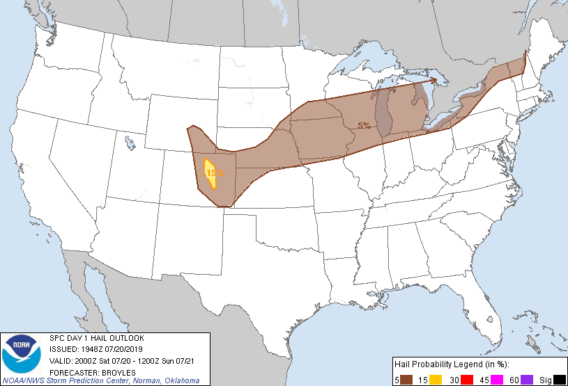 |
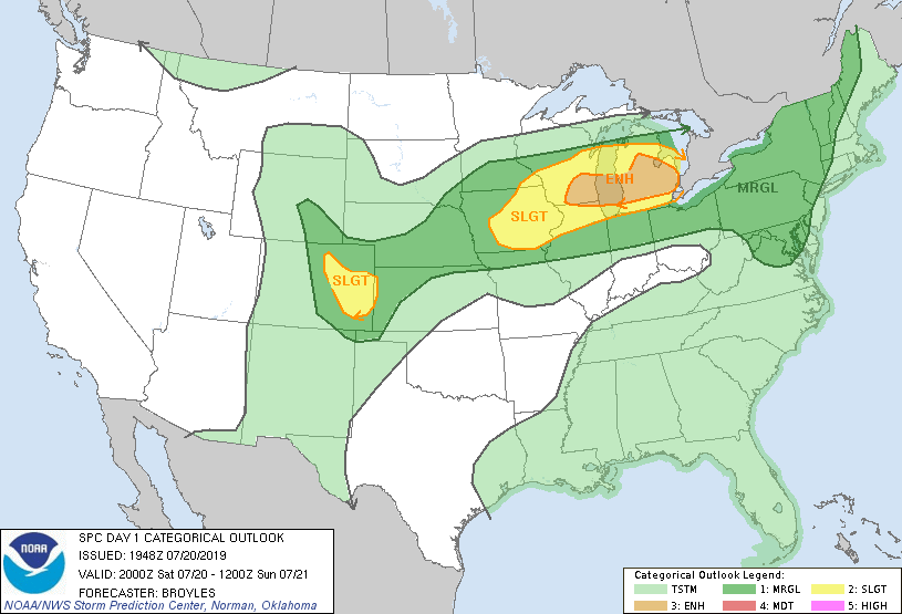
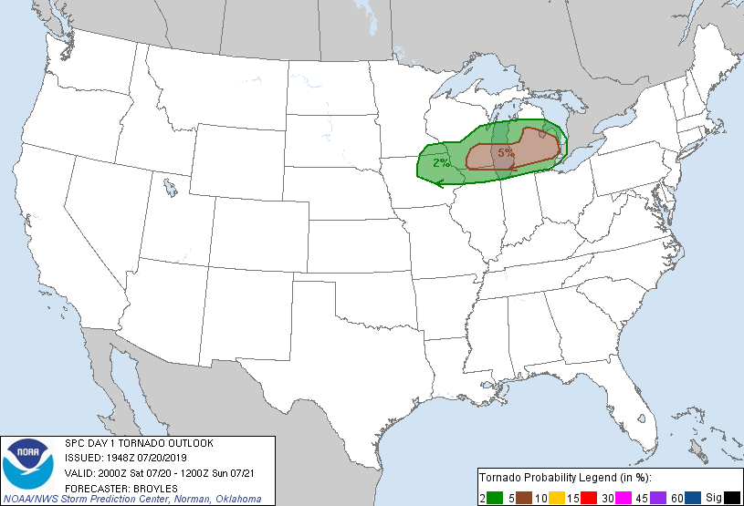
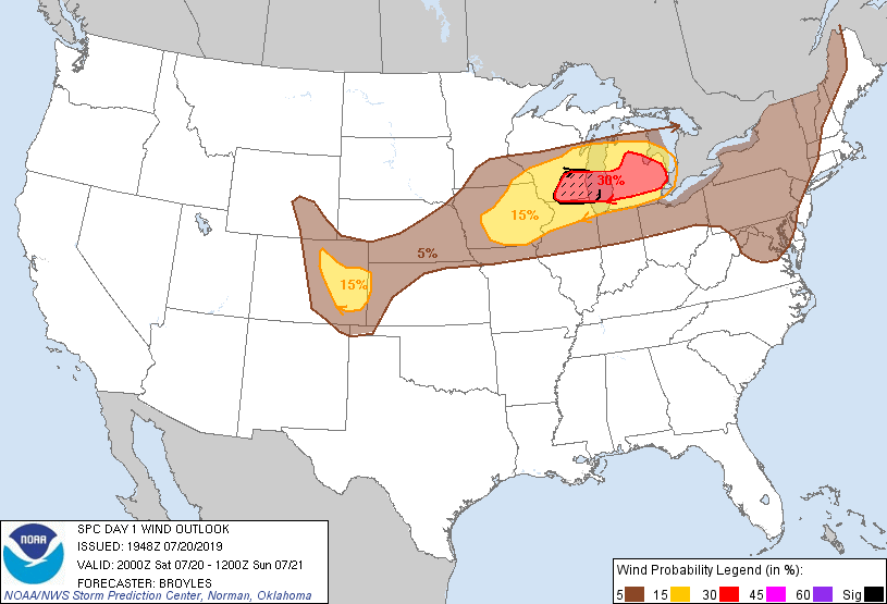
| SPC Day 1 Outlook (2000z) | SPC Day 1 Tornado Outlook (2000z) | SPC Day 1 Wind Outlook (2000z) | SPC Day 1 Hail Outlook (2000z) |
Local Sounding Analysis
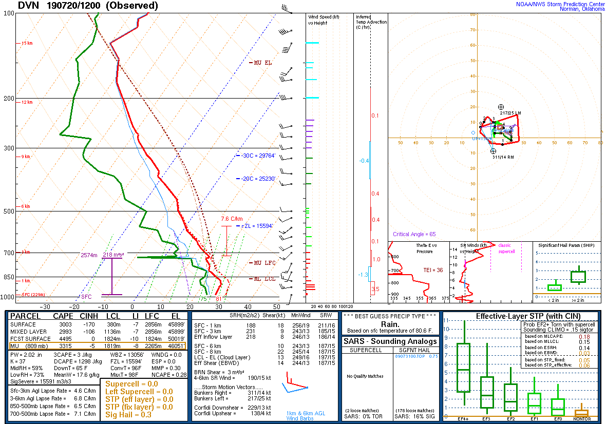 |
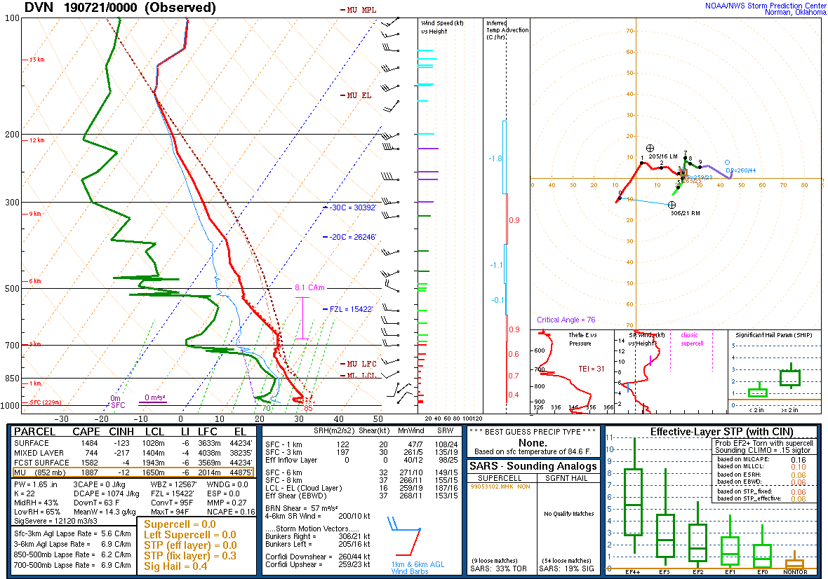 |
| DVN Sounding 7/20/19 12z | DVN Sounding 7/21/19 00z |
SPC Watches Issued For Our Area
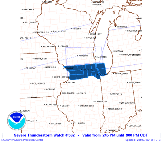 |
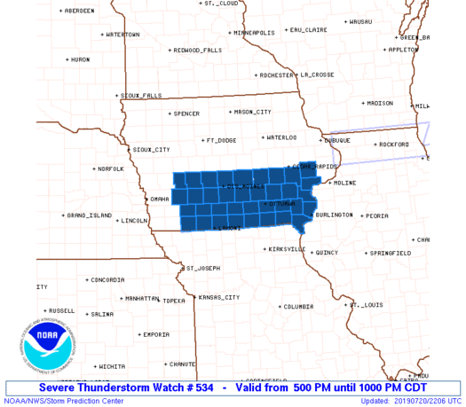 |
| SPC Severe Thunderstorm Watch #532 (see link for more details) | SPC Severe Thunderstorm Watch #534 (see link for more details) |
SPC Mesoscale Discussions Issued For Our Area
 |
 |
 |
||
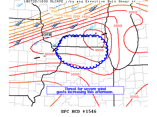
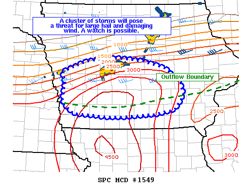
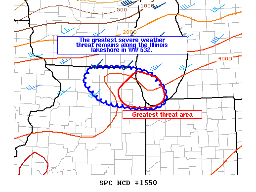
| SPC Mesoscale Discussion #1546 (see link for more details) | SPC Mesoscale Discussion #1549 (see link for more details) | SPC Mesoscale Discussion #1550 (see link for more details) |
SPC - Storm Prediction Center
 |
Media use of NWS Web News Stories is encouraged! Please acknowledge the NWS as the source of any news information accessed from this site. |
|