Scattered thunderstorms with severe gusts, hail and a tornado risk are possible near a cold front from the Ohio Valley to the Mid-Atlantic tonight. Tropical Storm Bertha is expected to bring tropical storm conditions to portions of the Gulf Coast from the panhandle of Florida into Louisiana through Wednesday. Read More >
Overview
|
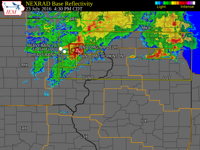
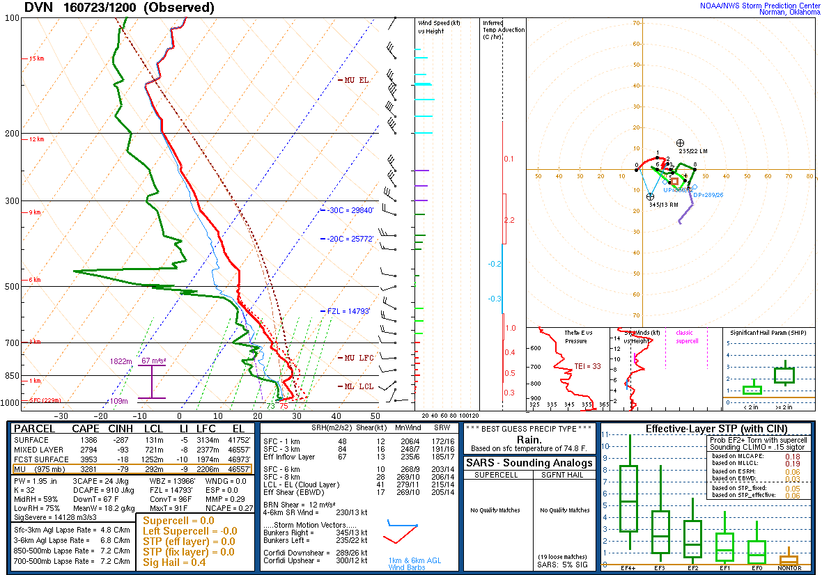
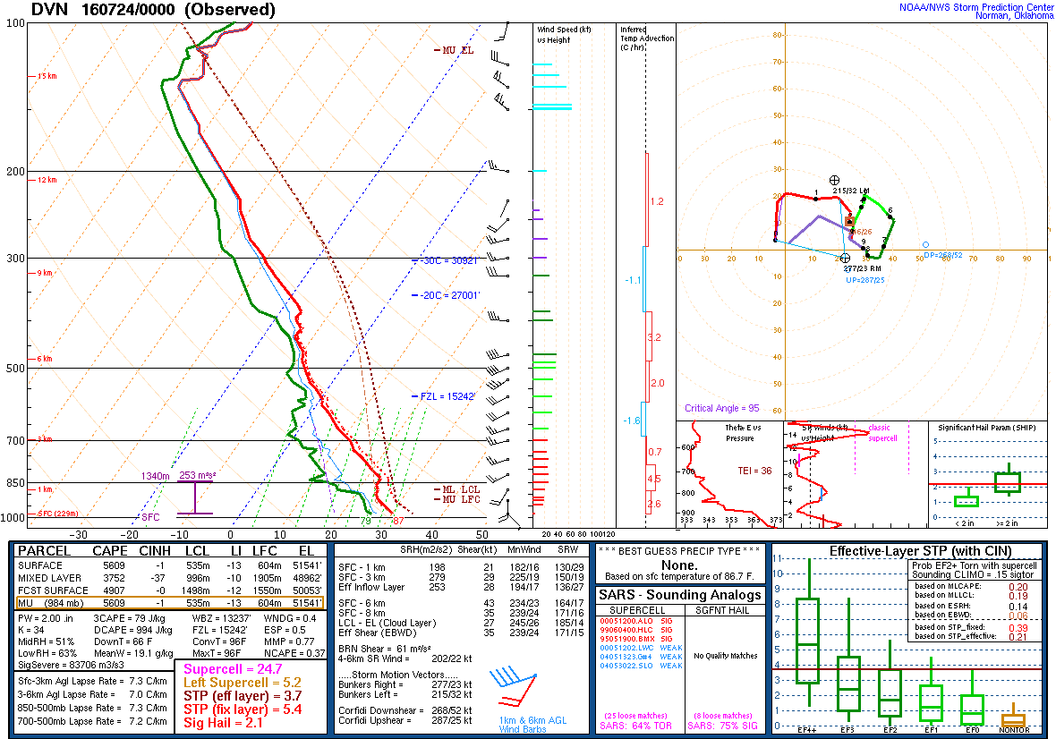
Saturday, July 23, was hot and humid with excessive heat over Iowa, Illinois and Missouri, and severe thunderstorms with tornadoes and torrential rain across parts of northeast Iowa and northwest Illinois. Rainfall amounts ranged from a trace at Iowa City, to nearly 3 inches near Independence. Flash flooding was reported in Independence and Monticello while tornadoes were reported near Delhi and Worthington. High temperatures ranged from 93 degrees at Keokuk and Fairfield to 81 degrees at Dubuque while the heat index was around 100. |
 |
| Tornado Tracks |
Tornadoes:
|
Tornado #1 - Near Masonville, IA
Preliminary Track Map 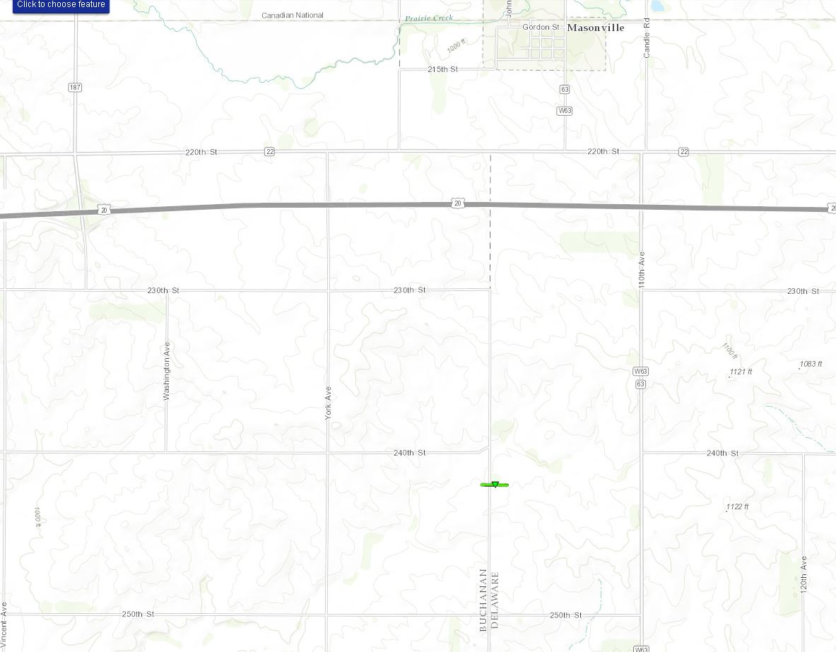 
|
||||||||||||||||
|
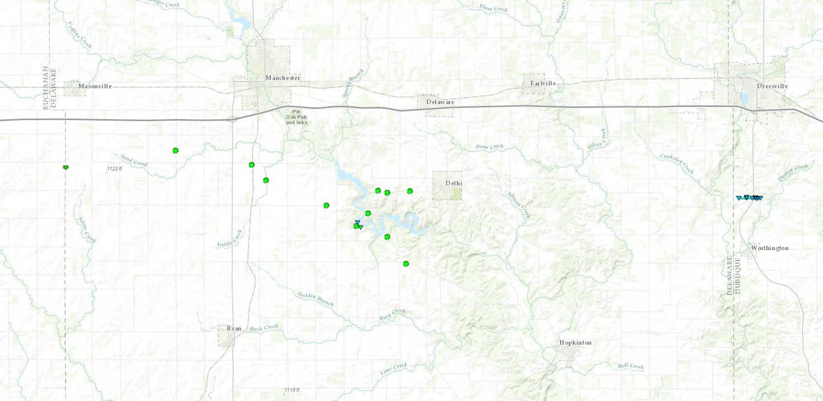
Tornado #2 - Delhi, IA
Preliminary Track Map .jpg)
|
||||||||||||||||
|
Tornado #3 - Worthington, IA
Preliminary Track Map .jpg)
|
||||||||||||||||
The Enhanced Fujita (EF) Scale classifies tornadoes into the following categories:
| EF0 Weak 65-85 mph |
EF1 Moderate 86-110 mph |
EF2 Significant 111-135 mph |
EF3 Severe 136-165 mph |
EF4 Extreme 166-200 mph |
EF5 Catastrophic 200+ mph |
 |
|||||
Storm Reports
| Interactive Map | SPC Storm Reports July 23, 2016 |
 |
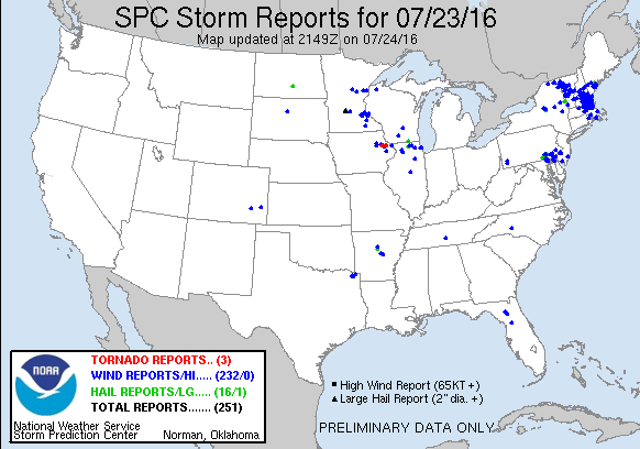 |
PRELIMINARY LOCAL STORM REPORT...SUMMARY
NATIONAL WEATHER SERVICE QUAD CITIES IA IL
1009 PM CDT SAT JUL 23 2016

..TIME...   ...EVENT...      ...CITY LOCATION...     ...LAT.LON...
..DATE...   ....MAG....      ..COUNTY LOCATION..ST.. ...SOURCE....
            ..REMARKS..

0328 PM     TSTM WND GST     1 N INDEPENDENCE        42.49N 91.89W
07/23/2016  E55.00 MPH       BUCHANAN           IA   TRAINED SPOTTER

            WIND GUSTS ESTIMATED 45-55 MPH

0330 PM     TSTM WND GST     1 WNW INDEPENDENCE      42.47N 91.91W
07/23/2016  M65.00 MPH       BUCHANAN           IA   TRAINED SPOTTER

            VERY HEAVY RAIN AND WINDS TO 65 MPH.

0335 PM     HEAVY RAIN       1 N INDEPENDENCE        42.49N 91.89W
07/23/2016  U0.00 INCH       BUCHANAN           IA   TRAINED SPOTTER

            TORRENTIAL RAIN HAS REDUCED VISIBILITY TO A FEW FEET.

0335 PM     TSTM WND DMG     1 N INDEPENDENCE        42.49N 91.89W
07/23/2016                   BUCHANAN           IA   TRAINED SPOTTER

            4 INCH DIAMETER BRANCH SNAPPED OFF TREE

0335 PM     TSTM WND GST     1 N INDEPENDENCE        42.49N 91.89W
07/23/2016  E65.00 MPH       BUCHANAN           IA   TRAINED SPOTTER

            WIND ESTIMATED 60 TO 65 MPH

0349 PM     TSTM WND GST     1 S HAZLETON            42.60N 91.91W
07/23/2016  E70.00 MPH       BUCHANAN           IA   EMERGENCY MNGR

            WIND ESTIMATED 70 TO 80 MPH DOWNED TREES AT CAMPGROUND

0349 PM     TSTM WND DMG     1 S HAZLETON            42.60N 91.91W
07/23/2016                   BUCHANAN           IA   EMERGENCY MNGR

            TREES DOWN AT CAMPGROUND.

0359 PM     HEAVY RAIN       INDEPENDENCE            42.47N 91.89W
07/23/2016  U0.00 INCH       BUCHANAN           IA   TRAINED SPOTTER

            WATER OVER THE CURBS IN INDEPENDENCE. SMALL CREEKS AND
            STREAMS ARE RISING RAPIDLY DUE TO TORRENTIAL RAIN.

0403 PM     HEAVY RAIN       1 E INDEPENDENCE        42.47N 91.88W
07/23/2016  M2.25 INCH       BUCHANAN           IA   TRAINED SPOTTER

            STILL RAINING

0403 PM     TSTM WND DMG     1 E INDEPENDENCE        42.47N 91.88W
07/23/2016                   BUCHANAN           IA   TRAINED SPOTTER

            NUMEROUS BRANCHES AND TREE LIMBS DOWN ACROSS TOWN.

0410 PM     TSTM WND DMG     MANCHESTER              42.49N 91.46W
07/23/2016                   DELAWARE           IA   PUBLIC

            2 ESTIMATED 8 INCH DIAMATER TREES DOWN. REPORT VIA
            TWITTER. TIME ESTIMATED BY RADAR.

0419 PM     HEAVY RAIN       JESUP                   42.48N 92.07W
07/23/2016  M3.60 INCH       BUCHANAN           IA   TRAINED SPOTTER

            1 HOUR RAINFALL.

0421 PM     TSTM WND DMG     NW DELHI                42.43N 91.33W
07/23/2016                   DELAWARE           IA   TRAINED SPOTTER

            3 LIMBS APPROXIMATELY 6 TO 12 INCHES IN DIAMETER WERE
            DOWN.

0424 PM     HEAVY RAIN       WSW QUASQUETON          42.39N 91.76W
07/23/2016  E1.61 INCH       BUCHANAN           IA   TRAINED SPOTTER

            1.61 INCHES RAIN BETWEEN 3:45 AND READING AT 4:30.  WINDS
            AND HEAVY RAIN FOR ABOUT 20 MINUTES. LEAVES AND TWIGS
            DOWN. NO OTHER DAMAGE NOTED. POND FORMED IN FRONT PASTURE
            FROM HEAVY RAIN. FREQUENT LIGHTING.

0424 PM     HEAVY RAIN       1 N INDEPENDENCE        42.49N 91.89W
07/23/2016  M1.77 INCH       BUCHANAN           IA   COCORAHS

            RAINFALL IN 30 MINUTES. WATER ON STREETS ON WEST SIDE OF
            TOWN.

0425 PM     TSTM WND DMG     HOPKINTON               42.34N 91.25W
07/23/2016                   DELAWARE           IA   TRAINED SPOTTER

            SEVERAL LARGE TREES AND BRANCHES DOWN. VIA FACEBOOK.
            REPORT WAS DELAYED AND TIME ESTIMATED USING RADAR.

0436 PM     FLASH FLOOD      INDEPENDENCE            42.47N 91.89W
07/23/2016                   BUCHANAN           IA   TRAINED SPOTTER

            FLASH FLOODING IN INDEPENDENCE GRAVEL ROAD AT HIGH SCHOOL
            COMPLEX IS WASHED OUT. THE PARKING LOT IS UNDER WATER.

0441 PM     TORNADO          WORTHINGTON             42.40N 91.12W
07/23/2016                   DUBUQUE            IA   TRAINED SPOTTER

            SPOTTER REPORTED A TORNADO NEAR WORTHINGTON.

0448 PM     TORNADO          FARLEY                  42.44N 91.01W
07/23/2016                   DUBUQUE            IA   LAW ENFORCEMENT

            LAW ENFORCEMENT REPORTED A TORNADO GOING UP AND DOWN NEAR
            FARLEY.

0450 PM     TSTM WND GST     MONTICELLO              42.24N 91.19W
07/23/2016  M50.00 MPH       JONES              IA   EMERGENCY MNGR

            WINDS AT THE JONES COUNTY FAIRGROUNDS NEAR MONTICELLO
            ESTIMATED 50 TO 60MPH

0505 PM     HEAVY RAIN       5 WSW HOPKINTON         42.32N 91.34W
07/23/2016  M1.66 INCH       DELAWARE           IA   COCORAHS

            1.66 INCHES IN THE PAST 40 MINS

0510 PM     TSTM WND GST     CASCADE                 42.30N 91.01W
07/23/2016  M40.00 MPH       DUBUQUE            IA   PUBLIC

            WIND 31 GUSTING TO 40

0515 PM     FLASH FLOOD      1 WNW INDEPENDENCE      42.47N 91.91W
07/23/2016                   BUCHANAN           IA   TRAINED SPOTTER

            HEAVY RAIN DETAILS 2.50-2.74 DURATION 40 MINUTES. STORM
            TOTAL RAINFALL FOR THE FIRST STORM EVENT THIS EVENING.
            STREAMS ARE OUT OF BANKS IN SPOTS. SOME LOCALIZED FLASH
            FLOODING CONTINUES IN SPOTS.

0528 PM     TSTM WND DMG     GALENA                  42.42N 90.43W
07/23/2016                   JO DAVIESS         IL   911 CALL CENTER

            POWER LINE DOWN

0530 PM     HEAVY RAIN       WYOMING                 42.06N 91.00W
07/23/2016  M1.50 INCH       JONES              IA   EMERGENCY MNGR

0530 PM     TSTM WND DMG     WYOMING                 42.06N 91.00W
07/23/2016                   JONES              IA   EMERGENCY MNGR

            PARTIAL TREES DOWN - TIME ESTIMATED

0550 PM     FLASH FLOOD      DUBUQUE                 42.50N 90.69W
07/23/2016                   DUBUQUE            IA   AMATEUR RADIO

            DOWNTOWN DUBUQUE HAS WATER OVER SEVERAL ROADS INCLUDING
            CENTRAL AVENUE AND JACKSON STREETS WITH SEVERAL STREETS
            CLOSED.

0600 PM     HEAVY RAIN       NE HOPKINTON            42.34N 91.25W
07/23/2016  M1.74 INCH       DELAWARE           IA   COCORAHS

            1.74 INCHES IN THE PAST 60 MINS. MINOR FLOODING. MULTIPLE
            TREES AND BRANCHES DOWN IN TOWN

0618 PM     HEAVY RAIN       1 E INDEPENDENCE        42.47N 91.88W
07/23/2016  M2.75 INCH       BUCHANAN           IA   TRAINED SPOTTER

0630 PM     FLASH FLOOD      MONTICELLO              42.24N 91.19W
07/23/2016                   JONES              IA   EMERGENCY MNGR

            1.5 FEET OF WATER ON TRACK AT FAIRGROUNDS.

0635 PM     HEAVY RAIN       SSW MAQUOKETA           42.06N 90.67W
07/23/2016  M1.50 INCH       JACKSON            IA   TRAINED SPOTTER

            RAINFALL IN PAST 30 MINUTES. RAIN CONTINUES.

0638 PM     TSTM WND GST     S ELWOOD                42.00N 90.73W
07/23/2016  E40.00 MPH       CLINTON            IA   LAW ENFORCEMENT

            SOUTH OF LOST NATION/ELWOOD PEA SIZED HAIL, HEAVY RAIN
            AND GUST WINDS UP TO 40 MPH REPORTED BY DEPUTY.

0646 PM     HEAVY RAIN       NE MAQUOKETA            42.07N 90.67W
07/23/2016  M2.00 INCH       JACKSON            IA   TRAINED SPOTTER

            LESS THAN AN HOUR

0720 PM     HEAVY RAIN       DAVIS                   42.42N 89.42W
07/23/2016  M0.75 INCH       STEPHENSON         IL   COCORAHS

            THERE IS SOME PONDING OF WATER IN THE YARD

0737 PM     TSTM WND GST     CLINTON MUNICIPAL AIRPO 41.83N 90.33W
07/23/2016  M44.00 MPH       CLINTON            IA   AWOS

0935 PM     HEAVY RAIN       4 ENE FREEPORT          42.32N 89.57W
07/23/2016  M1.00 INCH       STEPHENSON         IL   TRAINED SPOTTER

            0.85 INCHES OF RAIN FELL IN A 15 TO 20 MINUTE PERIOD AND
            THEN THE RAIN GRADUALLY TAPERED OFF.
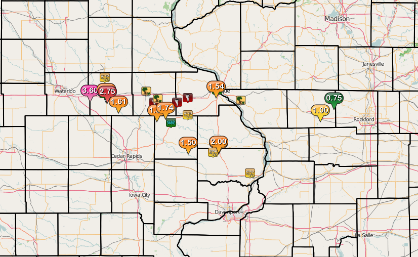
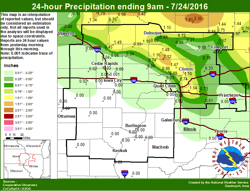
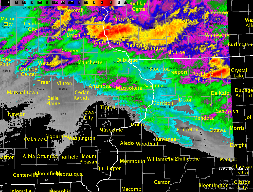
Rain Reports
 |
 |
| Figure 1: Local 24-hr Rainfall Ending 9 am 7/24/16 |
Figure 2: Multiple-Radar/Multiple-Sensor Estimated Rainfall Ending 3 am 07/23/16 |
Environment
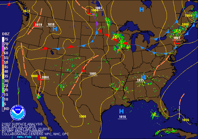 |
|||
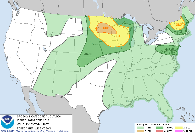
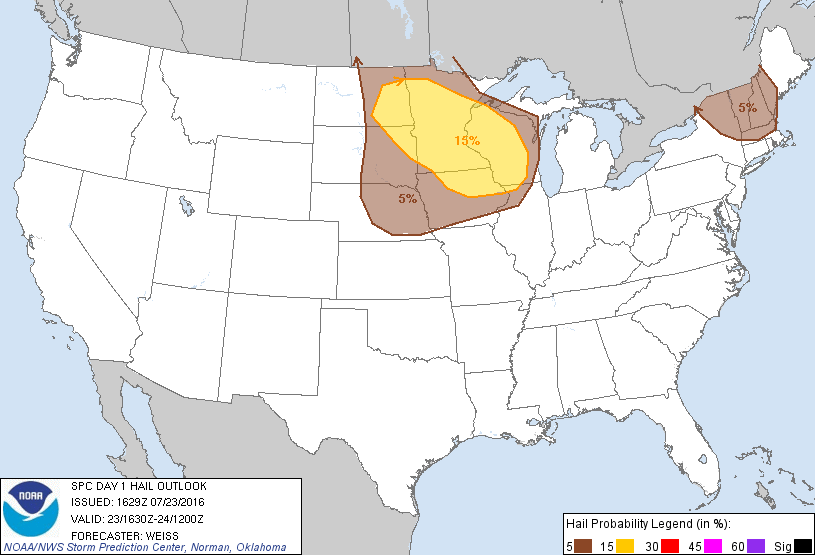
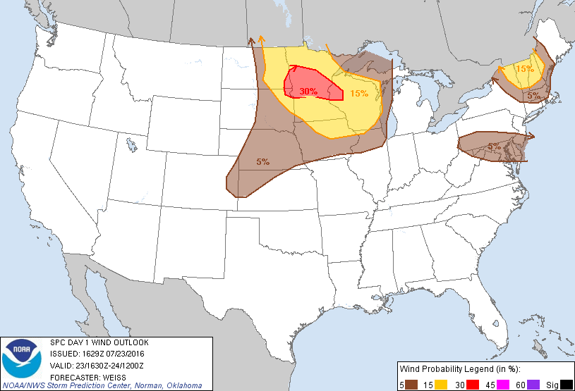
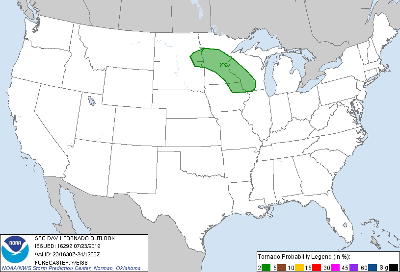
| SPC Event Wrap-up - July 23, 2016 | |||
 |
 |
 |
 |
| Figure 1: 1130 AM SPC Convective Outlook |
Figure 2: 1130 AM SPC Hail Outlook |
Figure 3: 1130 AM SPC Wind Outlook |
Figure 4: 1130 AM SPC Tornado Outlook |
 |
 |
| Figure 8: DVN 12z Sounding 7/23/16 |
Figure 9: DVN 00z Sounding 7/24/16 |
 |
Media use of NWS Web News Stories is encouraged! Please acknowledge the NWS as the source of any news information accessed from this site. |
|