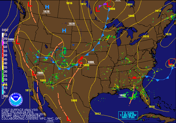
Overview
|
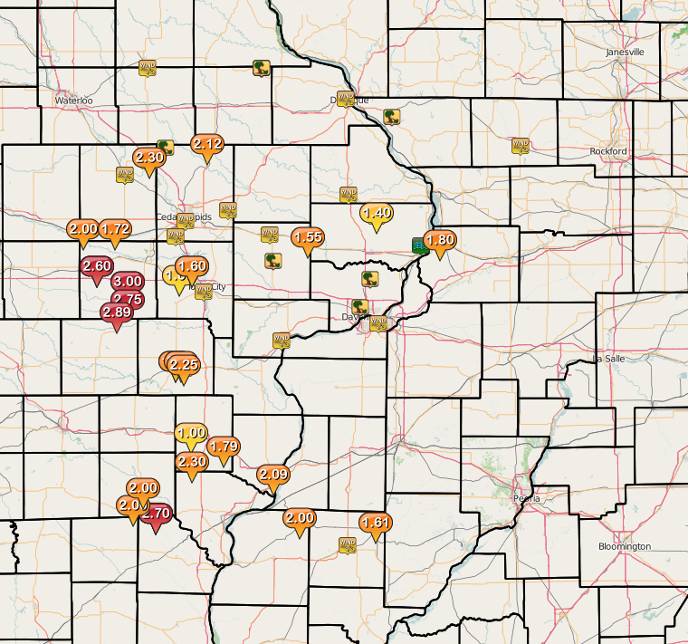
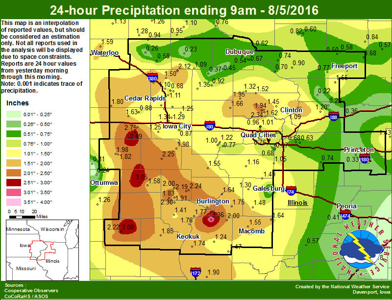
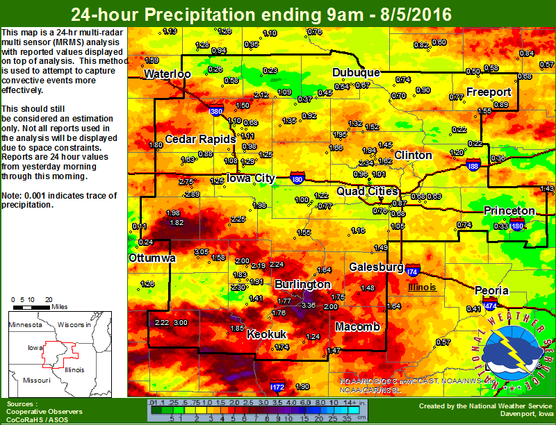
A line of strong to severe thunderstorms moved southeastward from central Iowa into northern Missouri and west central Illinois Thursday Night, ahead of a cold front that pushed eastward across the region. These storms brought damaging winds, torrential rain, and frequent lightning to the area. Several downed trees, power outages, and 40 to 60 mph winds were reported. Widespread rainfall amounts between 0.75 to 1.5 inches of rain fell in a short amount of time. Heavier totals over 3 inches, fell in portions of Keokuk and Washington counties in Iowa. Additional Information: |
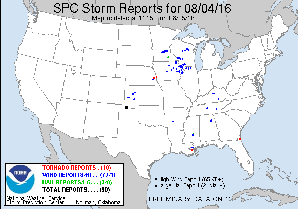
Storm Reports
| Interactive Report Map | SPC Storm Reports August 4, 2016 |
 |
 |
PRELIMINARY LOCAL STORM REPORT...SUMMARY
NATIONAL WEATHER SERVICE QUAD CITIES IA IL
904 AM CDT FRI AUG 05 2016

..TIME...   ...EVENT...      ...CITY LOCATION...     ...LAT.LON...
..DATE...   ....MAG....      ..COUNTY LOCATION..ST.. ...SOURCE....
            ..REMARKS..

0512 PM     TSTM WND GST     WSW URBANA              42.22N 91.88W
08/04/2016  M46.00 MPH       BENTON             IA   TRAINED SPOTTER

            WIND GUST MEASURED ON A HOME WEATHER STATION. ALSO
            REPORTED PEA SIZED HAIL FROM 608 TO 611.

0555 PM     TSTM WND GST     VINTON                  42.16N 92.03W
08/04/2016  M49.00 MPH       BENTON             IA   MESONET

            ALSO REPORTED BY BENTON COUNTY EM. DIME SIZE HAIL
            OCCURRED TOO.

0649 PM     TSTM WND GST     4 W STANLEY             42.64N 91.89W
08/04/2016  E50.00 MPH       BUCHANAN           IA   CO-OP OBSERVER

            REPORTED WINDS SUSTAINED OF 40 MPH WITH GUSTS OVER 50
            MPH.

0718 PM     TSTM WND DMG     COLESBURG               42.64N 91.20W
08/04/2016                   DELAWARE           IA   FIRE DEPT/RESCUE

            PART OF A STEEL ROOF BLOWN OFF A BUILDING ACROSS FROM THE
            FIRE DEPARTMENT.

0719 PM     TSTM WND DMG     COLESBURG               42.64N 91.20W
08/04/2016                   DELAWARE           IA   FIRE DEPT/RESCUE

            1 FOOT DIAMATER BRANCH FROM A 40 YEAR OLD MAPLE TREE
            BROKEN OFF.

0719 PM     TSTM WND DMG     COLESBURG               42.64N 91.20W
08/04/2016                   DELAWARE           IA   EMERGENCY MNGR

            SEVERAL LARGE TREE BRANCHES DOWN...TWO OF WHICH CAUSED
            DAMAGE TO ROOFS. POWER OUT THROUGH OUT TOWN.

0735 PM     TSTM WND GST     VINTON                  42.16N 92.03W
08/04/2016  M49.00 MPH       BENTON             IA   MESONET

            AT VINTON AIRPORT

0742 PM     TSTM WND DMG     SSE WALKER              42.28N 91.78W
08/04/2016                   LINN               IA   TRAINED SPOTTER

            LARGE TREE LIMBS DOWN LARGEER THAN 2 INCHES IN DIAMETER

0748 PM     TSTM WND DMG     SW DUBUQUE              42.50N 90.69W
08/04/2016                   DUBUQUE            IA   911 CALL CENTER

            NUMEROUS LIMBS DOWN WHERE HIGHWAY 52 COMES INTO DUBUQUE.
            SOME LIMBS WERE DOWN ON HOMES.

0750 PM     TSTM WND GST     DUBUQUE                 42.50N 90.69W
08/04/2016  M54.00 MPH       DUBUQUE            IA   ASOS

0805 PM     TSTM WND GST     1 SSE CEDAR RAPIDS      41.95N 91.66W
08/04/2016  E60.00 MPH       LINN               IA   TRAINED SPOTTER

0814 PM     TSTM WND GST     CEDAR RAPIDS MUNICIPAL  41.88N 91.72W
08/04/2016  M50.00 MPH       LINN               IA   ASOS

0818 PM     HEAVY RAIN       WSW URBANA              42.22N 91.88W
08/04/2016  M2.30 INCH       BENTON             IA   TRAINED SPOTTER

0818 PM     TSTM WND GST     3 WSW MARTELLE          42.00N 91.40W
08/04/2016  M55.00 MPH       LINN               IA   TRAINED SPOTTER

            ESTIMATED WIND SPEEDS OF 50 TO 55 MPH WITH SEVERAL 2 INCH
            DIAMETER WALNUT TREE BRANCHES DOWN.

0820 PM     TSTM WND DMG     1 E GALENA              42.42N 90.41W
08/04/2016                   JO DAVIESS         IL   LAW ENFORCEMENT

            TREE BLOWN DOWN ON MINER ROAD EAST OF GALENA.

0827 PM     HEAVY RAIN       W BELLE PLAINE          41.90N 92.28W
08/04/2016  M2.00 INCH       BENTON             IA   TRAINED SPOTTER

0830 PM     TSTM WND GST     STANWOOD                41.89N 91.15W
08/04/2016  E65.00 MPH       CEDAR              IA   TRAINED SPOTTER

0831 PM     HEAVY RAIN       WSW BLAIRSTOWN          41.90N 92.09W
08/04/2016  M1.72 INCH       BENTON             IA   TRAINED SPOTTER

0833 PM     TSTM WND DMG     TIPTON                  41.77N 91.13W
08/04/2016                   CEDAR              IA   LAW ENFORCEMENT

            SEVERAL REPORTS OF LIMBS AND TREES DOWN IN TIPTON. ONE
            LIMB FELL ON POWERLINES BRINGING THEM DOWN.

0834 PM     HEAVY RAIN       S WILLIAMSBURG          41.66N 92.01W
08/04/2016  M1.00 INCH       IOWA               IA   TRAINED SPOTTER

            1 INCH IN 15 MINUTES.

0847 PM     HEAVY RAIN       2 SW TIFFIN             41.69N 91.70W
08/04/2016  M1.06 INCH       JOHNSON            IA   TRAINED SPOTTER

            FELL IN 20 MINUTES

0849 PM     TSTM WND GST     IOWA CITY MUNICIPAL AIR 41.63N 91.55W
08/04/2016  M48.00 MPH       JOHNSON            IA   ASOS

0850 PM     TSTM WND GST     NNW MAQUOKETA           42.07N 90.67W
08/04/2016  E60.00 MPH       JACKSON            IA   TRAINED SPOTTER

            ESTIMATED USING RADAR

0900 PM     TSTM WND GST     FREEPORT                42.29N 89.63W
08/04/2016  E60.00 MPH       STEPHENSON         IL   EMERGENCY MNGR

            REPORTED 55-60 MPH ESTIMATED

0912 PM     HEAVY RAIN       2 SSW LADORA            41.73N 92.20W
08/04/2016  M1.75 INCH       IOWA               IA   TRAINED SPOTTER

0914 PM     TSTM WND GST     SW MUSCATINE            41.41N 91.08W
08/04/2016  E50.00 MPH       MUSCATINE          IA   TRAINED SPOTTER

            ALSO PEA TO DIME SIZED HAIL.

0915 PM     TSTM WND DMG     PARK VIEW               41.69N 90.54W
08/04/2016                   SCOTT              IA   NWS EMPLOYEE

            SEVERAL TREES DOWN AND SIGNIFICANT ROOF DAMAGE TO A STRIP
            MALL.

0915 PM     TSTM WND DMG     DAVENPORT               41.56N 90.60W
08/04/2016                   SCOTT              IA   PUBLIC

            SEVERAL TREES DOWN IN DAVENPORT. VIA FACEBOOK

0915 PM     TSTM WND GST     WASHINGTON AIRPORT      41.28N 91.67W
08/04/2016  M51.00 MPH       WASHINGTON         IA   AWOS

0926 PM     TSTM WND GST     MOLINE                  41.49N 90.49W
08/04/2016  M46.00 MPH       ROCK ISLAND        IL   ASOS

0930 PM     TSTM WND GST     2 WNW CHARLOTTE         41.97N 90.50W
08/04/2016  M52.00 MPH       CLINTON            IA   TRAINED SPOTTER

            TIME ESTIMATED USING RADAR

0952 PM     HEAVY RAIN       2 SSW LADORA            41.73N 92.20W
08/04/2016  M2.30 INCH       IOWA               IA   TRAINED SPOTTER

0952 PM     HEAVY RAIN       LOWDEN                  41.86N 90.92W
08/04/2016  M1.55 INCH       CEDAR              IA   CO-OP OBSERVER

            FELL IN 35 MINUTES...STILL LIGHT RAIN FALLING.

0953 PM     HEAVY RAIN       1 SSW NORTH LIBERTY     41.73N 91.62W
08/04/2016  M1.38 INCH       JOHNSON            IA   TRAINED SPOTTER

1000 PM     HEAVY RAIN       S WILLIAMSBURG          41.66N 92.01W
08/04/2016  M3.00 INCH       IOWA               IA   TRAINED SPOTTER

            SINCE 830 PM

1010 PM     HEAVY RAIN       1 W WASHINGTON          41.30N 91.72W
08/04/2016  E1.00 INCH       WASHINGTON         IA   TRAINED SPOTTER

            FELL IN 30 MINTUES.

1021 PM     HEAVY RAIN       2 WNW CHARLOTTE         41.97N 90.50W
08/04/2016  M1.40 INCH       CLINTON            IA   TRAINED SPOTTER

            IN THE PAST 75 MINTUES.

1050 PM     TSTM WND GST     MACOMB                  40.47N 90.68W
08/04/2016  E50.00 MPH       MCDONOUGH          IL   PUBLIC

            FROM SOCIAL MEDIA.

1058 PM     FLASH FLOOD      CLINTON                 41.84N 90.23W
08/04/2016                   CLINTON            IA   EMERGENCY MNGR

            STREET FLOODING IN THE CITY OF CLINTON WITH 1 TO 2 FEET
            OF WATER OVER SEVERAL INTERSECTIONS. RADAR ESTIMATES
            AMOUNTS OF OVER AN INCH IN ONE HOUR.

1059 PM     HEAVY RAIN       1 W WASHINGTON          41.30N 91.72W
08/04/2016  M1.90 INCH       WASHINGTON         IA   TRAINED SPOTTER

            IN THE PAST 2.5 HOURS

1100 PM     HEAVY RAIN       1 SW NORTH LIBERTY      41.73N 91.62W
08/04/2016  M1.60 INCH       JOHNSON            IA   TRAINED SPOTTER

1100 PM     HEAVY RAIN       2 ESE FULTON            41.85N 90.12W
08/04/2016  M1.80 INCH       WHITESIDE          IL   TRAINED SPOTTER

1100 PM     HEAVY RAIN       4 W MOUNT PLEASANT      40.97N 91.63W
08/04/2016  M1.00 INCH       HENRY              IA   TRAINED SPOTTER

            RAIN FELL IN 20 MINUTES.

1120 PM     HEAVY RAIN       2 SW NEW LONDON         40.91N 91.43W
08/04/2016  M1.79 INCH       HENRY              IA   TRAINED SPOTTER

            RAIN ACCUMULATED IN 1 HOUR AND 10 MIN.

0200 AM     HEAVY RAIN       3 ENE CHARLIE HEATH MEM 40.60N 91.84W
08/05/2016  M2.50 INCH       CLARK              MO   TRAINED SPOTTER

            SINCE MIDNIGHT. STILL RAINING LIGHTLY.

0352 AM     HEAVY RAIN       WNW PARNELL             41.58N 92.01W
08/05/2016  M2.75 INCH       IOWA               IA   TRAINED SPOTTER

            STORM TOTAL.

0539 AM     HEAVY RAIN       3 ENE CHARLIE HEATH MEM 40.60N 91.84W
08/05/2016  M2.70 INCH       CLARK              MO   TRAINED SPOTTER

            STORM TOTAL.

0636 AM     HEAVY RAIN       2 SSW LADORA            41.73N 92.20W
08/05/2016  M2.60 INCH       IOWA               IA   TRAINED SPOTTER

            STORM TOTAL.

0710 AM     HEAVY RAIN       WASHINGTON              41.30N 91.69W
08/05/2016  M2.25 INCH       WASHINGTON         IA   CO-OP OBSERVER

            STORM TOTAL.

0714 AM     HEAVY RAIN       1 S SALEM               40.84N 91.62W
08/05/2016  M2.30 INCH       HENRY              IA   CO-OP OBSERVER

            STORM TOTAL.

0714 AM     HEAVY RAIN       NORTH ENGLISH           41.52N 92.08W
08/05/2016  M2.89 INCH       IOWA               IA   CO-OP OBSERVER

            STORM TOTAL.

0715 AM     HEAVY RAIN       BURLINGTON REGIONAL AIR 40.78N 91.13W
08/05/2016  M2.09 INCH       DES MOINES         IA   ASOS

            STORM TOTAL.

0715 AM     HEAVY RAIN       COGGON                  42.28N 91.53W
08/05/2016  M2.12 INCH       LINN               IA   CO-OP OBSERVER

            STORM TOTAL.

0715 AM     HEAVY RAIN       LA HARPE                40.58N 90.97W
08/05/2016  M2.00 INCH       HANCOCK            IL   CO-OP OBSERVER

            STORM TOTAL.

0722 AM     HEAVY RAIN       NW BUSHNELL             40.56N 90.51W
08/05/2016  M1.61 INCH       MCDONOUGH          IL   TRAINED SPOTTER

            STORM TOTAL.

0726 AM     HEAVY RAIN       5 E CANTRIL             40.64N 91.98W
08/05/2016  M2.00 INCH       VAN BUREN          IA   TRAINED SPOTTER

            STORM TOTAL.

0744 AM     HEAVY RAIN       3 SSW BURLINGTON        40.77N 91.14W
08/05/2016  M2.75 INCH       DES MOINES         IA   TRAINED SPOTTER

            STORM TOTAL.

0745 AM     HEAVY RAIN       2 ESE KEOSAUQUA         40.72N 91.92W
08/05/2016  M2.00 INCH       VAN BUREN          IA   TRAINED SPOTTER

            STORM TOTAL.

0751 AM     HEAVY RAIN       WASHINGTON              41.28N 91.67W
08/05/2016  E2.25 INCH       WASHINGTON         IA   PUBLIC

            STORM TOTAL.

0809 AM     HEAVY RAIN       3 NNE DOWNING           40.52N 92.34W
08/05/2016  M3.90 INCH       SCOTLAND           MO   TRAINED SPOTTER

            STORM TOTAL.

0809 AM     HEAVY RAIN       S MEMPHIS               40.46N 92.17W
08/05/2016  M3.00 INCH       SCOTLAND           MO   COCORAHS

            STORM TOTAL.

0809 AM     HEAVY RAIN       3 SSE DALLAS CITY       40.59N 91.14W
08/05/2016  M3.36 INCH       HANCOCK            IL   COCORAHS

            STORM TOTAL.

0809 AM     HEAVY RAIN       1 SSW FULTON            41.85N 90.17W
08/05/2016  M2.30 INCH       WHITESIDE          IL   COCORAHS

            STORM TOTAL.

0809 AM     HEAVY RAIN       SSW PARNELL             41.58N 92.00W
08/05/2016  M2.75 INCH       IOWA               IA   COCORAHS

            STORM TOTAL.

0809 AM     HEAVY RAIN       1 WNW DEWITT            41.83N 90.56W
08/05/2016  M2.34 INCH       CLINTON            IA   COCORAHS

            STORM TOTAL.

0809 AM     HEAVY RAIN       1 NNW CENTER POINT      42.20N 91.78W
08/05/2016  M2.29 INCH       LINN               IA   COCORAHS

            STORM TOTAL.

0809 AM     HEAVY RAIN       1 ESE NEW LONDON        40.92N 91.39W
08/05/2016  M2.24 INCH       HENRY              IA   COCORAHS

            STORM TOTAL.

0809 AM     HEAVY RAIN       1 SSE BURLINGTON        40.80N 91.12W
08/05/2016  M2.21 INCH       DES MOINES         IA   COCORAHS

            STORM TOTAL.

0809 AM     HEAVY RAIN       1 SW NEW LONDON         40.92N 91.42W
08/05/2016  M2.19 INCH       HENRY              IA   COCORAHS

            STORM TOTAL.

0809 AM     HEAVY RAIN       1 W SIGOURNEY           41.33N 92.23W
08/05/2016  M1.98 INCH       KEOKUK             IA   COCORAHS

            STORM TOTAL.

0809 AM     HEAVY RAIN       6 WNW BURLINGTON        40.85N 91.22W
08/05/2016  M3.50 INCH       DES MOINES         IA   TRAINED SPOTTER

            STORM TOTAL.
Rain Reports
 |
 |
 |
 |
| Figure 1: Local 24-hr Rainfall |
Figure 2: Local Multiple-Radar/ Multiple-Sensor 24-Rainfall |
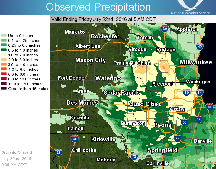
Figure 3: Regional 24-hr Rainfall ending 5 am 08/05/16 |
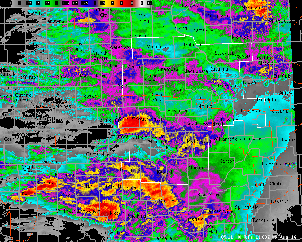
Figure 4: Multiple-Radar/ Multiple-Sensor Estimated Rainfall Ending 6 am 08/05/16 |
Public Information Statement
National Weather Service Quad Cities IA IL
806 AM CDT Fri Aug 5 2016

...Highest 24hr Rainfall Reports...

Observations are collected from a variety of sources with varying
equipment and exposures. Not all data listed are considered official.

Location                     Amount    Time/Date       Provider
2 NE Colusa                  3.36 in   0600 AM 08/05   COCORAHS
Fairfield                    3.05 in   0800 AM 08/05   COOP
North English                2.89 in   0700 AM 08/05   COOP
Parnell                      2.75 in   0356 AM 08/05   COCORAHS
Fairfield Arpt               2.53 in   0655 AM 08/05   AWOS
3 W Pleasant Grove           2.51 in   0746 AM 08/05   CWOP
Dewitt 1.4 WNW               2.34 in   0700 AM 08/05   COCORAHS
Burlington 2s                2.30 in   0700 AM 08/05   COOP
Fulton                       2.30 in   0600 AM 08/05   COCORAHS
Salem 1 S                    2.30 in   0700 AM 08/05   COOP
Center Point                 2.29 in   0600 AM 08/05   COCORAHS
Urbana                       2.28 in   0745 AM 08/05   CWOP
Washington                   2.25 in   0700 AM 08/05   COOP
New London 0.5 ESE           2.24 in   0625 AM 08/05   COCORAHS
Memphis                      2.22 in   0600 AM 08/05   COOP
Burlington                   2.21 in   0715 AM 08/05   COCORAHS
1 NNE Olin                   2.16 in   0755 AM 08/05   CWOP
Coggon                       2.12 in   0630 AM 08/05   COOP
Skunk Rvr At Sigourney       2.10 in   0730 AM 08/05   USGS
Burlington Arpt              2.09 in   0653 AM 08/05   ASOS
Williamsburg                 2.08 in   0753 AM 08/05   CWOP
Keokuk Arpt                  2.07 in   0655 AM 08/05   AWOS
Ms Rvr At Burlington         2.07 in   0700 AM 08/05   USARMY-COE
Wapsi Rvr At Oxford Jct      2.06 in   0730 AM 08/05   USGS
Henderson Crk At Oquawka     2.02 in   0730 AM 08/05   USGS
La Harpe                     2.00 in   0500 AM 08/05   COOP
Williamsburg                 2.00 in   0700 AM 08/05   COOP
4 N Haskins                  1.98 in   0700 AM 08/05   COCORAHS
Williamsburg                 1.95 in   0757 AM 08/05   CWOP
3 E Salem                    1.83 in   0700 AM 08/05   COCORAHS
Farmington                   1.82 in   0707 AM 08/05   RAWS
Sigourney                    1.82 in   0700 AM 08/05   COOP
Keosauqua                    1.82 in   0715 AM 08/05   COOP
1 WSW Spring Grove           1.82 in   0700 AM 08/05   COCORAHS
Garrison                     1.80 in   0737 AM 08/05   CWOP
Belle Plaine                 1.80 in   0700 AM 08/05   COOP
Fort Madison 0.9 NE          1.77 in   0700 AM 08/05   COCORAHS
Ms Rvr At Keithsburg         1.75 in   0730 AM 08/05   USARMY-COE
Cedar Crk Near Oakland Mills 1.74 in   0730 AM 08/05   USGS
Big Bear Creek At Ladora     1.72 in   0700 AM 08/05   USGS
Unionville                   1.71 in   0751 AM 08/05   CWOP
Pope Creek Near Keithsburg   1.69 in   0730 AM 08/05   USGS
English Rvr Near Parnell     1.66 in   0700 AM 08/05   USGS
Lowden                       1.66 in   0700 AM 08/05   COOP
Prairie City                 1.64 in   0600 AM 08/05   COOP
Marengo 2.6 SSW              1.63 in   0700 AM 08/05   COCORAHS
Macomb                       1.58 in   0700 AM 08/05   COOP
Keokuk L/d 19                1.57 in   0740 AM 08/05   USARMY-COE
Macomb Arpt                  1.57 in   0655 AM 08/05   AWOS
Macomb                       1.54 in   0649 AM 08/05   COCORAHS
2 NW Delmar                  1.52 in   0600 AM 08/05   COCORAHS
3 NNE Lafayette              1.50 in   0620 AM 08/05   COCORAHS
Alexis                       1.49 in   0730 AM 08/05   COOP
Gladstone L/d 18             1.46 in   0730 AM 08/05   COOP
2 ENE Argyle Lake State      1.45 in   0700 AM 08/05   COCORAHS
Cedar Rvr At Vinton          1.43 in   0715 AM 08/05   USGS
Ms Rvr Near Fort Madison     1.42 in   0730 AM 08/05   USARMY-COE
Wayland                      1.42 in   0730 AM 08/05   HADS
Donnellson                   1.41 in   0700 AM 08/05   COOP
Raritan                      1.39 in   0754 AM 08/05   CWOP
1 NE Marion                  1.35 in   0629 AM 08/05   COCORAHS
3 SSW Anamosa                1.35 in   0600 AM 08/05   COOP
1 WNW Oakdale                1.34 in   0700 AM 08/05   COCORAHS
4 W Maquoketa                1.32 in   0700 AM 08/05   COOP
Edwards Rvr At New Boston    1.31 in   0730 AM 08/05   USARMY-COE
Duck Crk Near West Lake      1.30 in   0715 AM 08/05   USGS
Cedar Rapids Arpt            1.28 in   0652 AM 08/05   ASOS
Fulton L/d 13                1.27 in   0730 AM 08/05   USARMY-COE
Clinton 1.7 W                1.26 in   0700 AM 08/05   COCORAHS
Cedar Rvr At Cedar Bluff     1.25 in   0700 AM 08/05   USGS
Bentley                      1.24 in   0645 AM 08/05   COOP
2 N Muscatine                1.22 in   0700 AM 08/05   COOP
New Boston L/d 17            1.21 in   0740 AM 08/05   USARMY-COE
Cedar Rvr At Conesville      1.21 in   0700 AM 08/05   USGS
2 SSW Malvern                1.20 in   0700 AM 08/05   COCORAHS
1 NNE North Liberty          1.19 in   0745 AM 08/05   CWOP
Wapsi Rvr At Oxford Jct      1.19 in   0745 AM 08/05   USGS
1 WNW Van Horne              1.17 in   0733 AM 08/05   CWOP
Stronghurst                  1.16 in   0758 AM 08/05   CWOP
3 ENE Bentley                1.12 in   0737 AM 08/05   CWOP
2 NE Cedar Rapids            1.11 in   0555 AM 08/05   COCORAHS
Camanche 1.2 W               1.09 in   0700 AM 08/05   COCORAHS
Swisher                      1.08 in   0700 AM 08/05   COOP
1 WSW Davenport              1.07 in   0700 AM 08/05   COCORAHS
1 ENE Marion                 1.06 in   0751 AM 08/05   CWOP
2 NNE New Windsor            1.05 in   0700 AM 08/05   COCORAHS
1 WNW Oakville               1.04 in   0700 AM 08/05   USGS
Hoover Creak Near West Branc 1.04 in   0745 AM 08/05   USGS
Fort Madison                 1.01 in   1200 AM 08/05   COOP
2 SSE Davenport              1.01 in   0530 AM 08/05   COCORAHS
1 N Muscatine                1.00 in   0700 AM 08/05   COCORAHS
Coralville                   0.99 in   0700 AM 08/05   HADS
2 ESE Scioto Mills           0.99 in   0753 AM 08/05   CWOP
Ely                          0.98 in   0600 AM 08/05   COCORAHS
1 NNE Credit Island          0.98 in   0530 AM 08/05   COCORAHS
1 E Hiawatha                 0.95 in   0756 AM 08/05   CWOP
Iowa Rvr At Columbus Jct     0.94 in   0700 AM 08/05   USARMY-COE
3 NNW Ely                    0.93 in   0755 AM 08/05   CWOP
Elizabeth                    0.90 in   0630 AM 08/05   COOP
Iowa Rvr At Marengo          0.89 in   0700 AM 08/05   USGS
1 ESE Freeport               0.89 in   0700 AM 08/05   COCORAHS
West Amana                   0.88 in   0700 AM 08/05   COCORAHS
1 ESE Coal Valley            0.87 in   0700 AM 08/05   COCORAHS
Moline                       0.87 in   0700 AM 08/05   COCORAHS
1 ENE Oak Grove              0.86 in   0758 AM 08/05   CWOP
Iowa Rvr At Iowa City        0.85 in   0700 AM 08/05   USGS
Ms Rvr At Fairport           0.85 in   0730 AM 08/05   USARMY-COE
Rock Island L/d 15           0.83 in   0730 AM 08/05   COOP
Galena Territory             0.83 in   0749 AM 08/05   CWOP
Cedar Rvr Near Palo          0.80 in   0715 AM 08/05   USGS
Freeport                     0.79 in   0730 AM 08/05   COOP
Davenport Arpt               0.78 in   0652 AM 08/05   ASOS
Davenport Nws                0.77 in   1200 AM 08/05   COOP
Rock Rvr At Moline           0.76 in   0730 AM 08/05   USARMY-COE
Quad City Intl Arpt          0.76 in   0652 AM 08/05   ASOS
Riverdale                    0.75 in   0630 AM 08/05   COCORAHS
Illinois City L/d 16         0.74 in   0730 AM 08/05   COOP
Rock Rvr Near Joslin         0.74 in   0730 AM 08/05   USGS
Galena                       0.74 in   0700 AM 08/05   COOP
Bellevue L/d 12              0.70 in   0730 AM 08/05   USARMY-COE
1 ESE Dubuque                0.70 in   0757 AM 08/05   CWOP
3 E Iowa City                0.69 in   0751 AM 08/05   CWOP
Davis                        0.68 in   0600 AM 08/05   COCORAHS
2 SSE Osborn                 0.68 in   0800 AM 08/05   CWOP
1 NW Geneseo                 0.68 in   0500 AM 08/05   COCORAHS
1 NW Marion                  0.68 in   0649 AM 08/05   COCORAHS
Wapsi Rvr At Dewitt          0.67 in   0730 AM 08/05   USGS
Dubuque Arpt                 0.67 in   0653 AM 08/05   ASOS
Green Rvr At Geneseo         0.66 in   0730 AM 08/05   USGS
Iowa Rvr Near Belle Plaine   0.66 in   0700 AM 08/05   USGS
1 E Dubuque                  0.64 in   0756 AM 08/05   CWOP
1 NE Geneseo                 0.63 in   0700 AM 08/05   COCORAHS
Iowa Rvr At Wapello          0.61 in   0700 AM 08/05   USGS
1 E Dubuque                  0.60 in   0757 AM 08/05   CWOP
Dubuque #3                   0.59 in   0700 AM 08/05   COOP
Freeport Arpt                0.58 in   0655 AM 08/05   AWOS
Le Claire L/d 14             0.56 in   0730 AM 08/05   COOP
Ms Rvr At Dubuque            0.54 in   0730 AM 08/05   USARMY-COE
Coralville Dam               0.54 in   0800 AM 08/05   USARMY-COE
1 ESE Edmore                 0.54 in   0730 AM 08/05   HADS
2 ESE Davenport              0.53 in   0758 AM 08/05   CWOP
Kewanee Municipal            0.51 in   0758 AM 08/05   CWOP
2 NNE Mc Connell             0.50 in   0700 AM 08/05   COCORAHS
Cascade                      0.45 in   0700 AM 08/05   COOP
Monticello Arpt              0.44 in   0655 AM 08/05   AWOS
Independence                 0.38 in   0752 AM 08/05   CWOP
1 N Stockton                 0.38 in   0900 PM 08/04   COOP
Monticello                   0.37 in   0700 AM 08/05   COOP
1 SSE Julien                 0.33 in   0758 AM 08/05   CWOP
Wapsi Rvr At Independence    0.33 in   0730 AM 08/05   USGS
Big Bureau Crk Near Princeto 0.30 in   0745 AM 08/05   USGS
1 SE Princeton               0.30 in   0700 AM 08/05   COCORAHS
1 S Princeton                0.29 in   0700 AM 08/05   COCORAHS
1 WNW Eldridge               0.28 in   0754 AM 08/05   CWOP
Vinton Arpt                  0.28 in   0655 AM 08/05   AWOS
Mount Carroll                0.28 in   0755 AM 08/05   CWOP
1 NE Sterling                0.27 in   0759 AM 08/05   CWOP
Cedar Rapids                 0.25 in   0816 PM 08/04   CWOP
Maquoketa River At Mancheste 0.24 in   0715 AM 08/05   USGS
Manchester                   0.23 in   0700 AM 08/05   COOP
1 SW Coleta                  0.22 in   0700 AM 08/05   COCORAHS
2 WSW Chadwick               0.22 in   0700 AM 08/05   COCORAHS
Environment
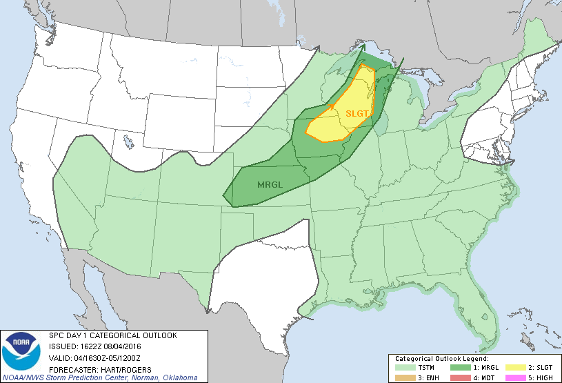
| SPC Event Wrap-up - August 4, 2016 | ||
 |
 |
 |
| Figure 1: 1130 AM SPC Convective Outlook |
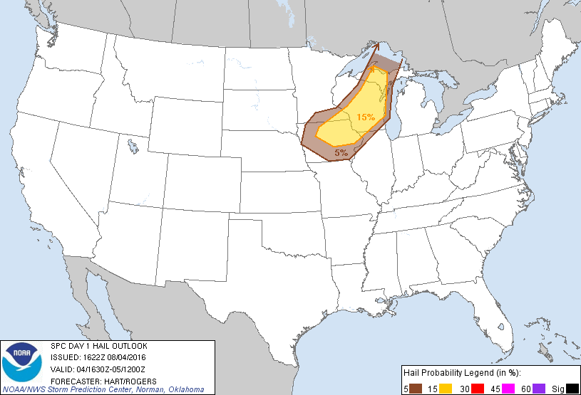
Figure 2: 1130 AM SPC Hail Outlook |
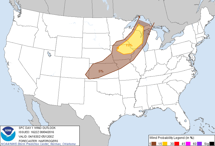
Figure 3: 1130 AM SPC Wind Outlook |
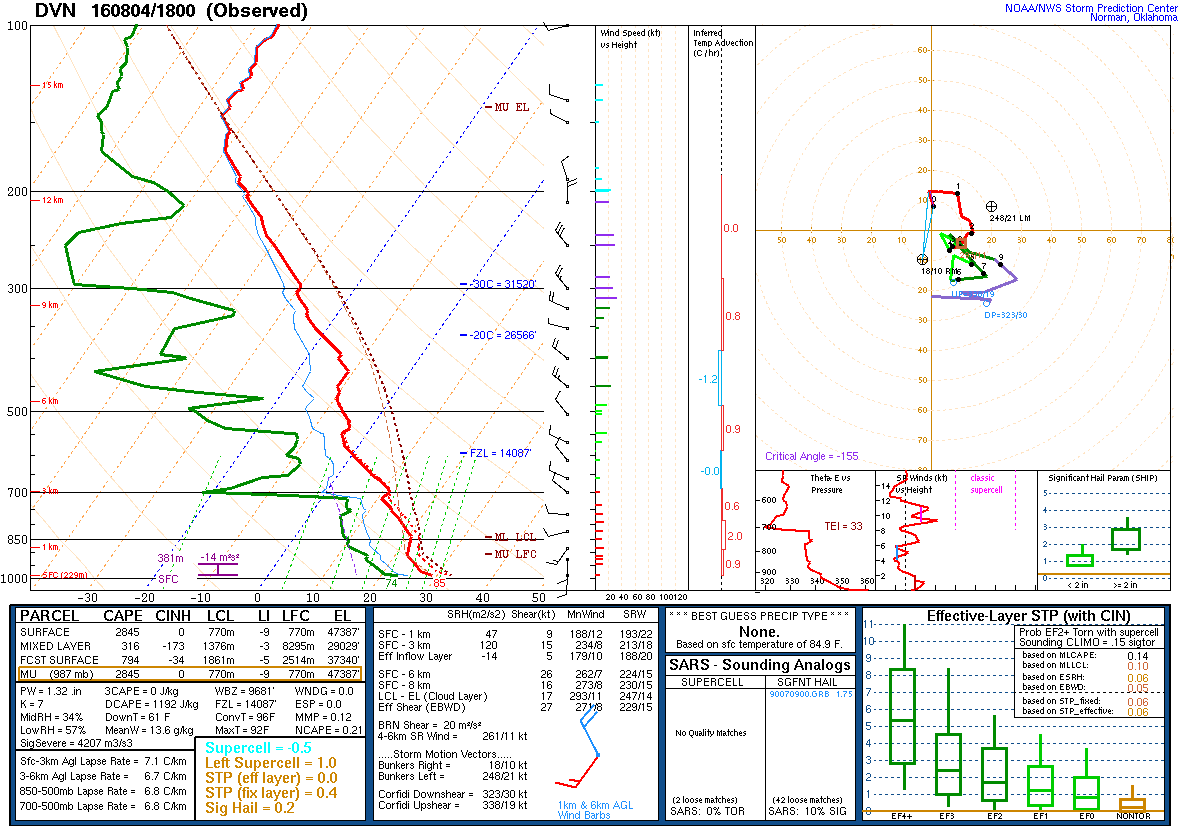 |
| Figure 4: DVN 8/4 18z Sounding |
 |
Media use of NWS Web News Stories is encouraged! Please acknowledge the NWS as the source of any news information accessed from this site. |
|