Overview
|
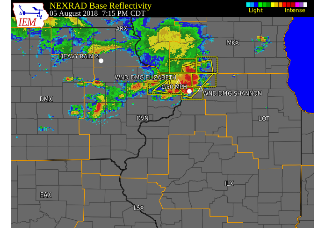
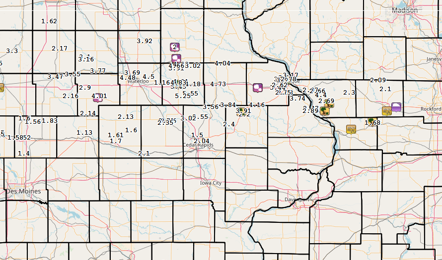
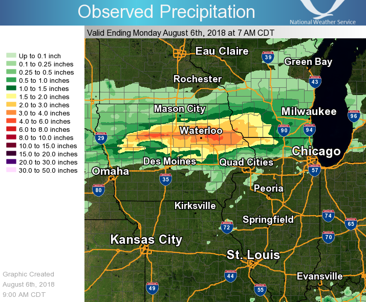
A complex of showers and thunderstorms moving from northeast Iowa to northwest Illinois produced severe weather on the evening of August 5th. Strong winds were reported with damage to trees in Independence, Monticello, Dubuque, Elizabeth, IL, and Freeport. Rain continued over areas along highway 20 throughout the evening, with rainfall totals between 2 and 5 inches common by Monday morning. |
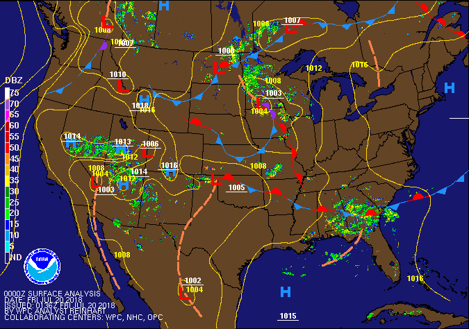 Weather Prediction Center Pressure / Fronts |
Storm Reports
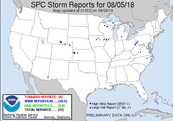
| Interactive Storm Map | SPC Storm Reports |
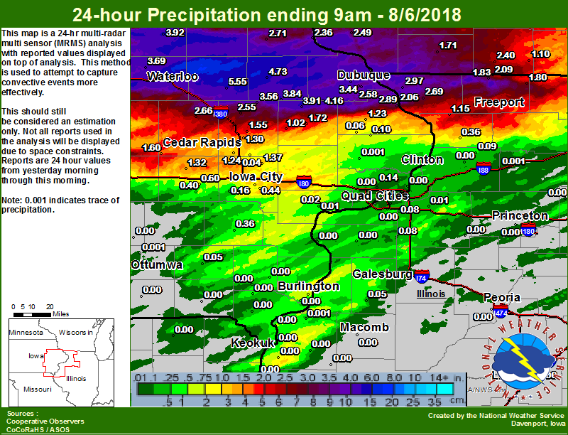
Regional Rainfall Amounts ending 7 am 8/6 |
 |
 |
 |
| Local Rainfall Ending 9 am 8/6 | ||
 |
PRELIMINARY LOCAL STORM REPORT...SUMMARY
NATIONAL WEATHER SERVICE QUAD CITIES IA IL
958 AM CDT MON AUG 6 2018

..TIME...   ...EVENT...      ...CITY LOCATION...     ...LAT.LON...
..DATE...   ....MAG....      ..COUNTY LOCATION..ST.. ...SOURCE....
            ..REMARKS..

0605 PM     HAIL             FARLEY                  42.44N 91.01W
08/05/2018  E1.00 INCH       DUBUQUE            IA   BROADCAST MEDIA

            REPORT RELAYED FROM KCRG.

0605 PM     HAIL             FARLEY                  42.44N 91.01W
08/05/2018  M0.88 INCH       DUBUQUE            IA   TRAINED SPOTTER

            ALSO MEASURED WIND GUSTS AROUND 45 MPH.

0630 PM     HEAVY RAIN       JESUP                   42.48N 92.07W
08/05/2018  M1.16 INCH       BUCHANAN           IA   TRAINED SPOTTER

            RAIN FELL BETWEEN 430 AND 5 PM.

0715 PM     TSTM WND GST     MOUNT CARROLL           42.10N 89.98W
08/05/2018  E50 MPH          CARROLL            IL   TRAINED SPOTTER

            ESTIMATED 50 MPH WIND GUSTS IN MOUNT
            CARROLL.

0740 PM     TSTM WND GST     FREEPORT ALBERTUS       42.25N 89.58W
08/05/2018  M59 MPH          STEPHENSON         IL   AWOS

            MEASURED WIND GUST OF 51 KTS.

0821 AM     HEAVY RAIN       HAZLETON                42.62N 91.91W
08/06/2018  M4.66 INCH       BUCHANAN           IA   MESONET

            MESONET STATION F1749, HAZLETON.

0800 AM     HEAVY RAIN       BELLEVUE L/D 12         42.27N 90.42W
08/06/2018  M2.47 INCH       JO DAVIESS         IL   MESONET

            MESONET STATION BLVI4, BELLEVUE L/D 12.

0650 AM     HEAVY RAIN       DUBUQUE ARPT            42.40N 90.71W
08/06/2018  M2.58 INCH       DUBUQUE            IA   ASOS

            ASOS STATION DBQ, DUBUQUE ARPT.

0700 AM     HEAVY RAIN       1 NW ONECO              42.50N 89.68W
08/06/2018  M2.09 INCH       STEPHENSON         IL   COCORAHS

            COCORAHS STATION IL-SP-3, 1 NW ONECO.

0730 AM     HEAVY RAIN       2 NNE CEDAR RAPIDS      42.01N 91.66W
08/06/2018  M1.30 INCH       LINN               IA   TRAINED SPOTTER

            STORM TOTAL.

0800 AM     HEAVY RAIN       BELLEVUE 0.3 SSW        42.25N 90.43W
08/06/2018  M2.89 INCH       JACKSON            IA   COCORAHS

            COCORAHS STATION IA-JC-5, BELLEVUE 0.3 SSW.

0600 AM     HEAVY RAIN       4 WNW FOUNTAIN SPRINGS  42.64N 91.40W
08/06/2018  M4.04 INCH       DELAWARE           IA   TRAINED SPOTTER


0700 AM     HEAVY RAIN       VINTON                  42.17N 92.00W
08/06/2018  M2.66 INCH       BENTON             IA   CO-OP OBSERVER

            CO-OP OBSERVER STATION VNTI4, VINTON.

0700 AM     HEAVY RAIN       DUBUQUE #3              42.40N 90.73W
08/06/2018  M2.75 INCH       DUBUQUE            IA   CO-OP OBSERVER

            CO-OP OBSERVER STATION DUBI4, DUBUQUE #3.

0700 AM     HEAVY RAIN       ASBURY                  42.51N 90.77W
08/06/2018  M3.90 INCH       DUBUQUE            IA   COCORAHS

            COCORAHS STATION IA-DB-20, ASBURY.

0418 AM     HEAVY RAIN       2 ENE ASBURY            42.52N 90.72W
08/06/2018  M3.10 INCH       DUBUQUE            IA   TRAINED SPOTTER

            STORM TOTAL.

0734 AM     HEAVY RAIN       BELLE PLAINE            41.90N 92.27W
08/06/2018  E2.10 INCH       BENTON             IA   PUBLIC

            24 HOUR EVENT TOTAL.

0655 AM     HEAVY RAIN       MONTICELLO ARPT         42.22N 91.16W
08/06/2018  M2.20 INCH       JONES              IA   AWOS

            AWOS STATION MXO, MONTICELLO ARPT.

0630 AM     HEAVY RAIN       ELIZABETH               42.33N 90.25W
08/06/2018  M2.69 INCH       JO DAVIESS         IL   CO-OP OBSERVER

            CO-OP OBSERVER STATION EZBI2, ELIZABETH.

0700 AM     HEAVY RAIN       3 N STOCKTON            42.40N 90.00W
08/06/2018  M2.30 INCH       JO DAVIESS         IL   CO-OP OBSERVER

            RAINFALL SINCE 7 PM YESTERDAY.

0700 AM     HEAVY RAIN       CASCADE                 42.30N 91.02W
08/06/2018  M4.16 INCH       DUBUQUE            IA   CO-OP OBSERVER

            CO-OP OBSERVER STATION CASI4, CASCADE.

0555 AM     HEAVY RAIN       1 NE HIAWATHA           42.05N 91.68W
08/06/2018  E1.50 INCH       LINN               IA   TRAINED SPOTTER

            STORM TOTAL.

0700 AM     HEAVY RAIN       MANCHESTER              42.47N 91.45W
08/06/2018  M4.73 INCH       DELAWARE           IA   CO-OP OBSERVER

            CO-OP OBSERVER STATION MHRI4, MANCHESTER.

0645 AM     HEAVY RAIN       3 NNE LAFAYETTE         42.20N 91.65W
08/06/2018  M2.55 INCH       LINN               IA   COCORAHS

            COCORAHS STATION IA-LN-7, 3 NNE LAFAYETTE.

0817 AM     HEAVY RAIN       INDEPENDENCE            42.47N 91.88W
08/06/2018  M3.82 INCH       BUCHANAN           IA   MESONET

            MESONET STATION E8796, INDEPENDENCE.

0600 AM     HEAVY RAIN       1 W AFOLKEY             42.43N 89.60W
08/06/2018  M2.10 INCH       STEPHENSON         IL   COCORAHS

            COCORAHS STATION IL-SP-23, 1 W AFOLKEY.

0730 AM     HEAVY RAIN       1 N CENTER GROVE        42.50N 90.72W
08/06/2018  M3.91 INCH       DUBUQUE            IA   COCORAHS

            COCORAHS STATION IA-DB-19, 1 N CENTER GROVE.

0820 AM     HEAVY RAIN       2 ENE CEDAR RAPIDS      42.00N 91.63W
08/06/2018  M2.04 INCH       LINN               IA   MESONET

            MESONET STATION CDRPD, 2 ENE CEDAR RAPIDS.

0800 AM     HEAVY RAIN       DUBUQUE L/D 11          42.54N 90.65W
08/06/2018  M3.17 INCH       DUBUQUE            IA   MESONET

            MESONET STATION DLDI4, DUBUQUE L/D 11.

0700 AM     HEAVY RAIN       2 SSE BUCK CREEK        42.30N 91.34W
08/06/2018  M3.84 INCH       DELAWARE           IA   COCORAHS

            COCORAHS STATION IA-DW-6, 2 SSE BUCK CREEK.

0437 AM     HEAVY RAIN       2 ENE HAZLETON          42.63N 91.86W
08/06/2018  M4.23 INCH       BUCHANAN           IA   CO-OP OBSERVER

            STORM TOTAL SO FAR, STILL RAINING.

0823 AM     HEAVY RAIN       BUCHANAN CO MOBILE TRAI 42.49N 91.86W
08/06/2018  M4.01 INCH       BUCHANAN           IA   MESONET

            MESONET STATION F1559, BUCHANAN CO MOBILE
            TRAILER.

0735 AM     HEAVY RAIN       ROWLEY                  42.37N 91.84W
08/06/2018  M5.25 INCH       BUCHANAN           IA   PUBLIC

            STORM TOTAL, RELAYED BY DMX.

0815 AM     HEAVY RAIN       CEDAR RVR AT VINTON     42.17N 92.02W
08/06/2018  M2.71 INCH       BENTON             IA   MESONET

            MESONET STATION VINI4, CEDAR RVR AT VINTON.

0827 AM     HEAVY RAIN       1 SSE JULIEN            42.46N 90.77W
08/06/2018  M2.62 INCH       DUBUQUE            IA   MESONET

            MESONET STATION D9981, 1 SSE JULIEN.

0605 AM     HEAVY RAIN       QUASQUETON 0.4 WSW      42.39N 91.76W
08/06/2018  M5.55 INCH       BUCHANAN           IA   COCORAHS

            COCORAHS STATION IA-BC-2, QUASQUETON 0.4
            WSW.

0700 AM     HEAVY RAIN       SHANNON                 42.15N 89.74W
08/06/2018  M1.68 INCH       CARROLL            IL   COCORAHS


0829 AM     HEAVY RAIN       VINTON                  42.15N 92.03W
08/06/2018  M2.35 INCH       BENTON             IA   MESONET

            MESONET STATION C2988, VINTON.

0829 AM     HEAVY RAIN       GALENA TERRITORY        42.41N 90.35W
08/06/2018  M2.66 INCH       JO DAVIESS         IL   MESONET

            MESONET STATION D7485, GALENA TERRITORY.

0630 AM     HEAVY RAIN       COGGON                  42.28N 91.53W
08/06/2018  M3.56 INCH       LINN               IA   CO-OP OBSERVER

            CO-OP OBSERVER STATION CGGI4, COGGON.

0714 AM     HEAVY RAIN       MONTICELLO              42.25N 91.17W
08/06/2018  M3.91 INCH       JONES              IA   CO-OP OBSERVER

            CO-OP OBSERVER STATION MCLI4, MONTICELLO.

0830 AM     HEAVY RAIN       WAPSI RVR AT INDEPENDEN 42.45N 91.89W
08/06/2018  M3.43 INCH       BUCHANAN           IA   MESONET

            MESONET STATION IDPI4, WAPSI RVR AT
            INDEPENDENCE.

0817 AM     HEAVY RAIN       FONTANA COUNTY PARK     42.60N 91.91W
08/06/2018  M3.91 INCH       BUCHANAN           IA   MESONET

            MESONET STATION F1748, FONTANA COUNTY PARK.

0700 AM     HEAVY RAIN       GALENA                  42.42N 90.43W
08/06/2018  M2.97 INCH       JO DAVIESS         IL   CO-OP OBSERVER

            CO-OP OBSERVER STATION GPBI2, GALENA.

0831 AM     HEAVY RAIN       1 E DUBUQUE             42.51N 90.67W
08/06/2018  M2.78 INCH       DUBUQUE            IA   MESONET

            MESONET STATION D8823, 1 E DUBUQUE.

0650 AM     HEAVY RAIN       CENTER POINT            42.19N 91.78W
08/06/2018  M3.02 INCH       LINN               IA   COCORAHS

            COCORAHS STATION IA-LN-30, CENTER POINT.

0833 AM     HEAVY RAIN       AURORA                  42.62N 91.73W
08/06/2018  M3.02 INCH       BUCHANAN           IA   MESONET

            MESONET STATION F1481, AURORA.

0833 AM     HEAVY RAIN       INDEPENDENCE            42.47N 91.89W
08/06/2018  M3.93 INCH       BUCHANAN           IA   MESONET

            MESONET STATION F1476, INDEPENDENCE.

0833 AM     HEAVY RAIN       WINTHROP                42.47N 91.73W
08/06/2018  M4.18 INCH       BUCHANAN           IA   MESONET

            MESONET STATION F1482, WINTHROP.

0700 AM     HEAVY RAIN       2 SSW JULIEN            42.44N 90.79W
08/06/2018  M3.44 INCH       DUBUQUE            IA   COCORAHS

            COCORAHS STATION IA-DB-16, 2 SSW JULIEN.

0834 AM     HEAVY RAIN       1 N INDEPENDENCE        42.48N 91.89W
08/06/2018  M4.83 INCH       BUCHANAN           IA   MESONET

            MESONET STATION F0270, 1 N INDEPENDENCE.

0925 AM     HEAVY RAIN       2 SE GALENA TERRITORY   42.38N 90.31W
08/06/2018  M4.40 INCH       JO DAVIESS         IL   TRAINED SPOTTER

            STORM TOTAL, JUST ENDED.

0952 AM     HEAVY RAIN       2 NNE STONE CITY        42.14N 91.33W
08/06/2018  M2.40 INCH       JONES              IA   TRAINED SPOTTER

            STORM TOTAL/.
Environment
|
|
|
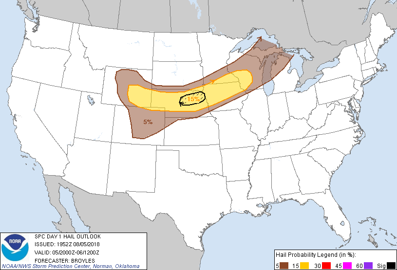 |
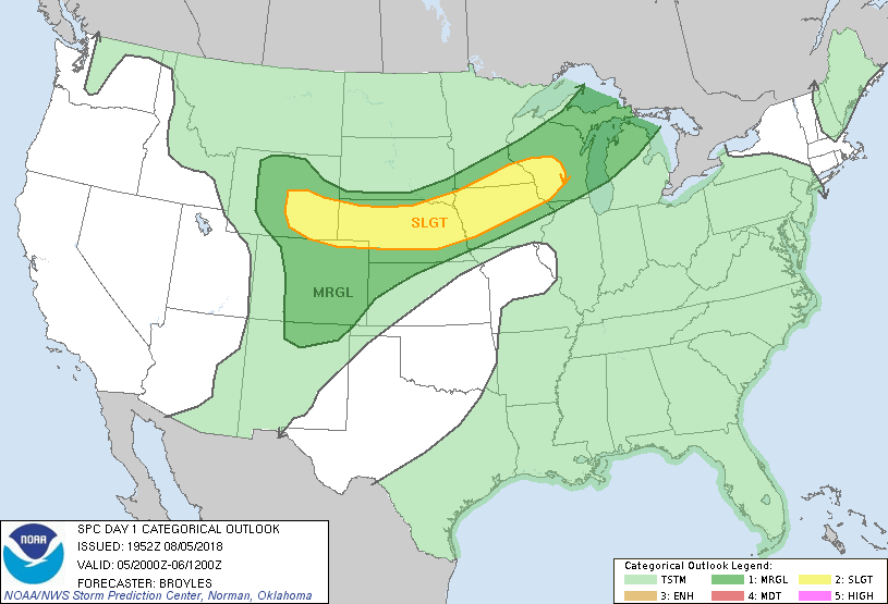
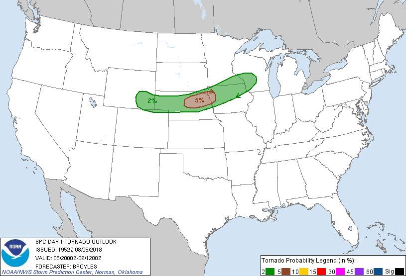
| Day 1 Outlook (2000z) | Day 1 Tornado (2000z) | Day 1 Hail (2000z) |
|
|
|
|
| Day 1 Wind (2000z) |
 |
Media use of NWS Web News Stories is encouraged! Please acknowledge the NWS as the source of any news information accessed from this site. |
|