Overview
|
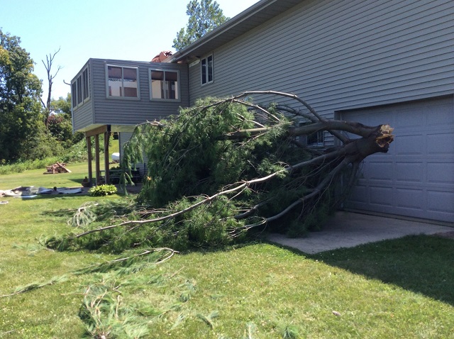
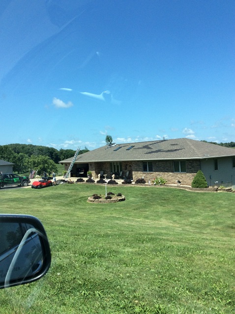
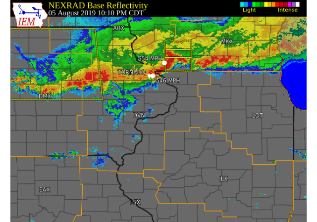
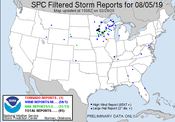
A line of thunderstorms moved south southeast across the region during the late evening hours of Monday, August 5, 2019. These storms mainly produced wind gusts of 40 to 55 MPH, frequent lightning, and brief torrential rains. An isolated tornado touched down west of the Dubuque Airport at 1007 PM. Later, around 1040 PM, tree damage occurred in Cedar Rapids. |
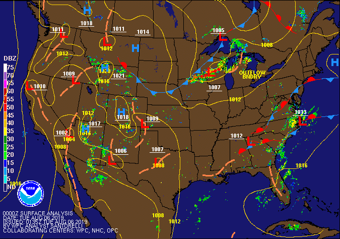 Radar and Surface Map |
Tornadoes:
|
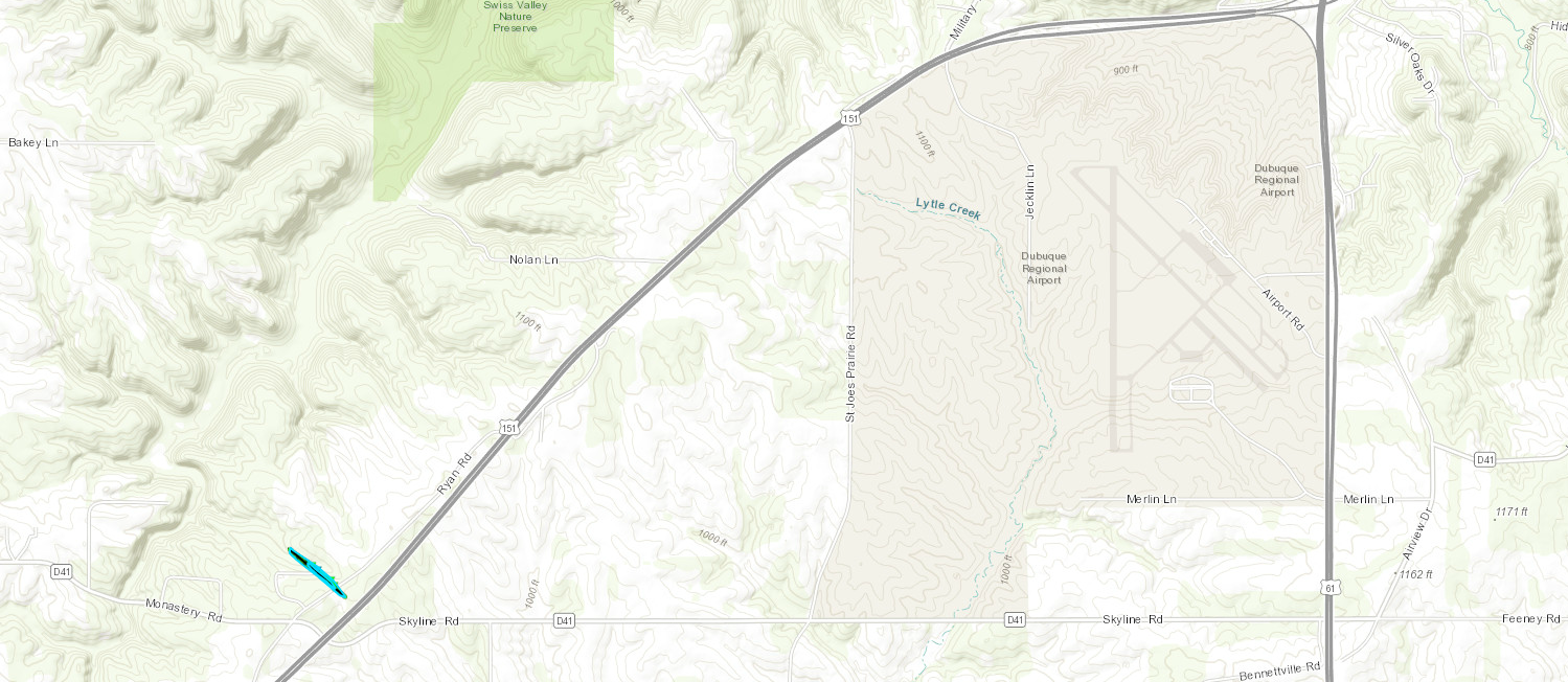
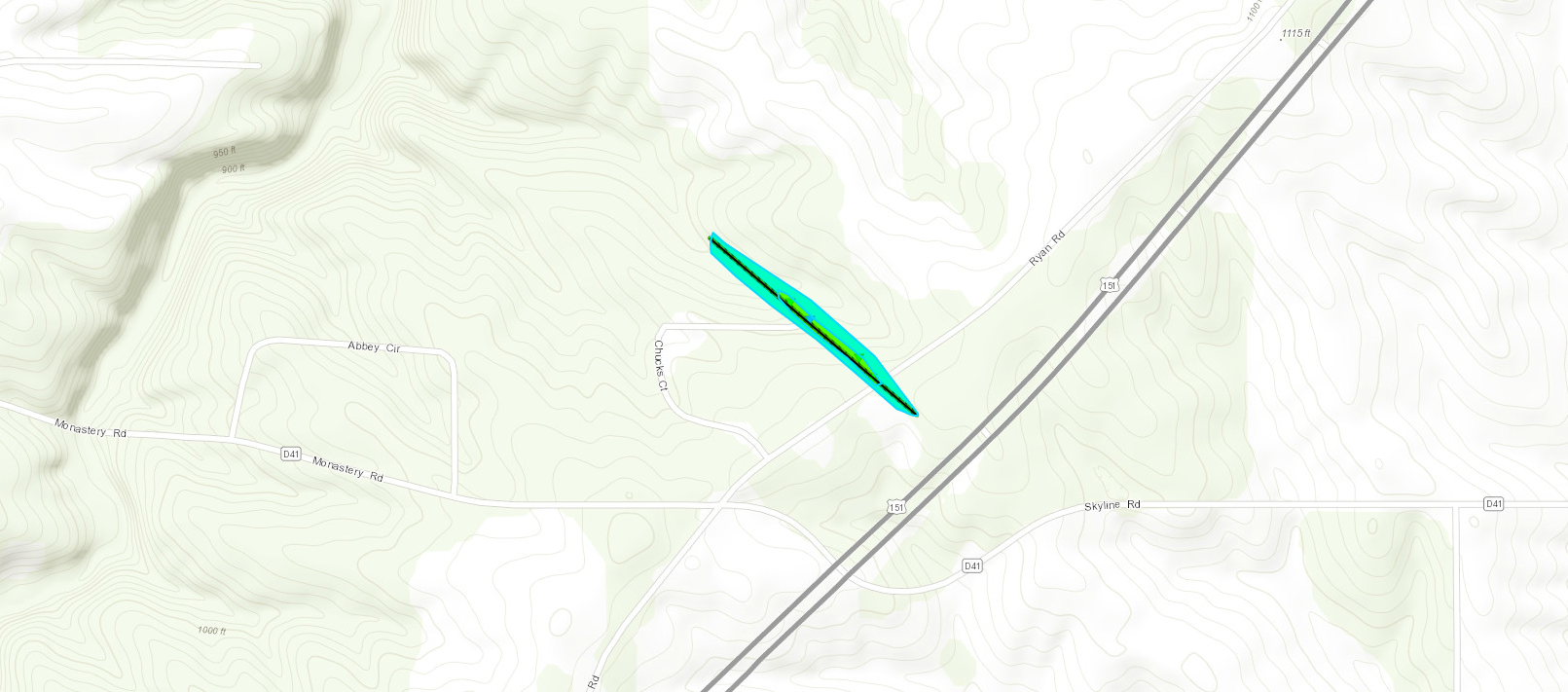
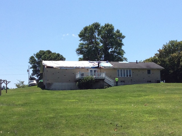
Tornado - 3 WSW Dubuque Airport
|
||||||||||||||||
The Enhanced Fujita (EF) Scale classifies tornadoes into the following categories:
| EF0 Weak 65-85 mph |
EF1 Moderate 86-110 mph |
EF2 Significant 111-135 mph |
EF3 Severe 136-165 mph |
EF4 Extreme 166-200 mph |
EF5 Catastrophic 200+ mph |
 |
|||||
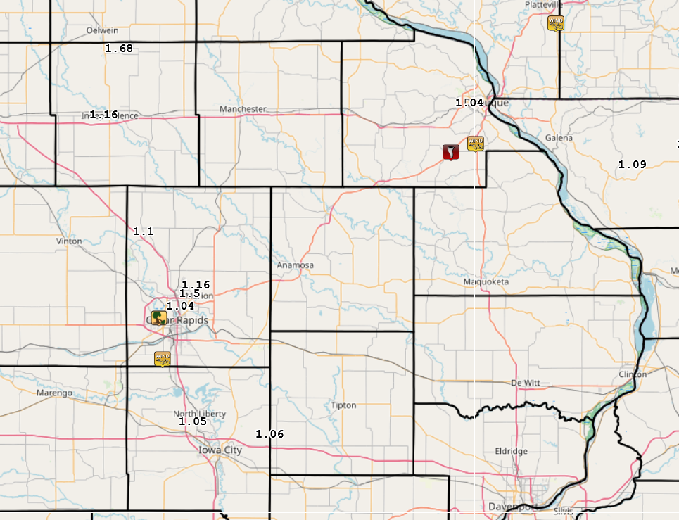
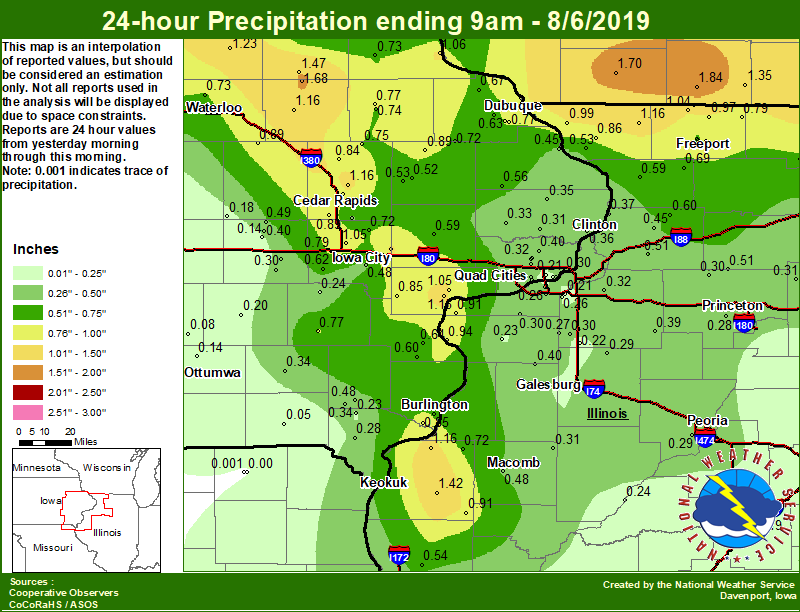
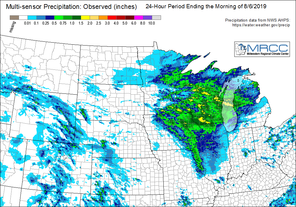
Rain Reports
| Local Rainfall | Regional Rainfall |
 |
 |
24 hour precipitation reports (in Inches),
for eastern Iowa, northwest and west central Illinois,
and northeast Missouri. Reported between Midnight and 9 AM,
Tuesday August 06, 2019.

....IOWA....
Stanley                          1.68
Oelwein 1E                       1.47
Tripoli 0 N                      1.23
Hampton 1 N                      1.18
Independence 0.9 WNW             1.16
Marion 1.7 NNW                   1.16
Muscatine 1.4 N                  1.15
Center Point 0.6 NNW             1.10
Guttenberg Dam 10                1.06
West Branch 2.0 NNW              1.06
North Liberty 0.7 SSW            1.05
Muscatine 2N                     1.05
Dubuque 1.4 WSW                  1.04
Dubuque LD11                     0.97
Mount Auburn 2.2 NNW             0.89
Cedar Rapids Arpt 5 SW           0.89
Monticello 1 E                   0.89
Nichols 3.2 SSW                  0.85
Burlington 6.5 SSW               0.85
Central City 6.7 W               0.84
Fairfax 4.0 NW                   0.83
Cedar Rapids 2.7 NE              0.83
Cresco 1 NE                      0.79
Tiffin 1.8 SW                    0.79
Manchester 1.1 N                 0.77
Dubuque Arpt 7 SW                0.77
Dubuque #3 7 SW                  0.77
Washington 5.8 SW                0.77
Coggon                           0.75
Manchester                       0.74
Elkader 6SSW                     0.73
Asbury 0.4 SW                    0.73
Waterloo ASOS 5 NW               0.73
Burlington Arpt 2 SW             0.72
Solon 0.3 ESE                    0.72
Cascade                          0.72
Rickardsville 0.2 W              0.67
Wapello 0.2 S                    0.64
Peosta 2.9 E                     0.63
Bellevue LD12                    0.62
Kalona 7.3 NNW                   0.62
Morning Sun 1.7 E                0.60
Tipton 0.7 N                     0.59
Maquoketa 4 W                    0.56
Iowa City Arpt                   0.53
Anamosa 3 SSW                    0.53
Anamosa 1.9 SE                   0.52
Fayette 1 NW                     0.50
Marengo 3.6 N                    0.49
Iowa City                        0.48
Salem 3.1 ESE                    0.48
Bellevue 0.3 SSW                 0.45
Ely 0.5 SE                       0.45
Marshalltown 1 NW                0.40
Marengo                          0.40
Park View 0.2 WSW                0.40
Camanche 1.2 W                   0.36
Williamsburg                     0.36
Charlotte 1.9 WNW                0.35
Davenport Arpt 5 N               0.35
Salem 1S                         0.34
Fairfield                        0.34
Calamus 2.0 NE                   0.33
Grinnell 2 SW                    0.33
Eldridge 0.7 SSW                 0.32
Eldridge 0.6 S                   0.31
Bettendorf 2.2 SE                0.31
Mason City ASOS 6 W              0.31
De Witt                          0.31
Le Claire LD14                   0.30
Parnell 0.1 SSW                  0.30
Donnellson                       0.28
Davenport 0.9 SSW                0.27
Davenport 0.9 WNW                0.27
Grinnell AWOS 2 SSW              0.27
Marshalltown ASOS 4 N            0.25
Wellman 4.0 E                    0.24
Riverdale 0.5 N                  0.24
West Point 7.5 NW                0.23
Mason City 1 NNE                 0.22
Oskaloosa 1 NNW                  0.21
Bettendorf 1.6 WSW               0.21
Sigourney                        0.20
Belle Plaine                     0.18
Marengo 2.6 SSW                  0.14
Ottumwa ASOS 6 NNW               0.14
Toledo 3 N                       0.09
Oskaloosa AWOS 9 ESE             0.08
Keosauqua                        0.05
Boone 1 SSW                      0.02
NWS Johnston* 5 NNW              0.00
Rathbun Reservoir 2 N            0.00
Perry 0 W                        0.00
Centerville 0 NE                 0.00
Beaconsfield 1 NNE               0.00
Pella AWOS 2 WSW                 0.00
....ILLINOIS....
Bentley                          1.42
Orangeville 2.8 NW               1.27
Dallas City 3.0 SSE              1.16
Stockton 3.4 NNE                 1.16
Winslow 4.3 ESE                  1.04
Galena                           0.99
Dakota 4.8 NW                    0.97
Freeport                         0.95
New Boston LD17                  0.94
Roscoe 2SE                       0.93
Augusta                          0.91
Illinois City 6.7 SW             0.91
Freeport 1.7 ESE                 0.86
Elizabeth                        0.86
Freeport 2.9 WSW                 0.80
Davis 0.5 N                      0.79
Ill. City LD16 3 WNW             0.78
Rockford ASOS                    0.72
La Harpe                         0.72
Freeport 1.7 NW                  0.70
Freeport 2.0 NW                  0.69
Shannon 0.2 S                    0.69
Coleta 1.4 SSW                   0.60
Mount Carroll                    0.59
Rochelle                         0.55
Quincy ASOS                      0.54
Hanover 0.2 NW                   0.53
Prophetstown 0.2 SW              0.51
Walnut 5.3 ENE                   0.51
Colchester 3.5 NE                0.48
Ottawa 4 SW                      0.45
Morrison 3.2 E                   0.45
Alexis 1 SW                      0.40
Kewanee 1 E                      0.39
Fulton LD13                      0.37
Rochelle AWOS                    0.35
Decatur Airport                  0.32
Geneseo 2.0 NW                   0.32
Mendota 2 SE                     0.31
Prairie City 2S                  0.31
Milan 8.8 SSW                    0.30
Alpha 2.3 N                      0.30
Quad City Arpt 3 S               0.30
Walnut                           0.30
Princeton 1.1 SE                 0.29
Princeton                        0.29
Peoria ASOS                      0.29
Altona                           0.29
Tiskilwa 2.1 N                   0.28
New Windsor 2.0 N                0.27
Bloomington Airport              0.27
Moline 1.0 WNW                   0.26
Coal Valley 1.9 SE               0.26
Galesburg                        0.25
Havana                           0.24
Aledo                            0.23
Mundelein                        0.22
Woodhull 0.3 ESE                 0.22
Coal Valley 2.6 E                0.21
Steward                          0.19
Lincoln NWS                      0.19
Galesburg Arpt 3 SW              0.18
Paw Paw 1 E                      0.16
Romeoville                       0.09
Joliet                           0.04
Windsor                          0.02
Jacksonville AWOS                0.02
Tuscola                          0.02
Ogden                            0.01
Streator 3 SE                    0.00
St Anne                          0.00
....MISSOURI....
Memphis                          0.00
Kirksville ASOS                  0.00
Memphis 0.1 S                    0.00
Chillicothe 2 NW                 0.00
Columbia                         0.00
....WISCONSIN....
Monroe 1 W                       1.84
Darlington                       1.70
Brodhead 1 SW                    1.35
Beloit-College                   1.34
Madison-ASOS                     1.20
Viroqua                          0.76
La Crosse WFO                    0.46
Allenton-WWTP .6 NW              0.42
Watertown-AWOS                   0.00
Prairie du Chien AWOS            0.00
....MINNESOTA....
Grand Meadow                     2.30
Preston                          1.20
|
|
Environment
 |
 |
 |
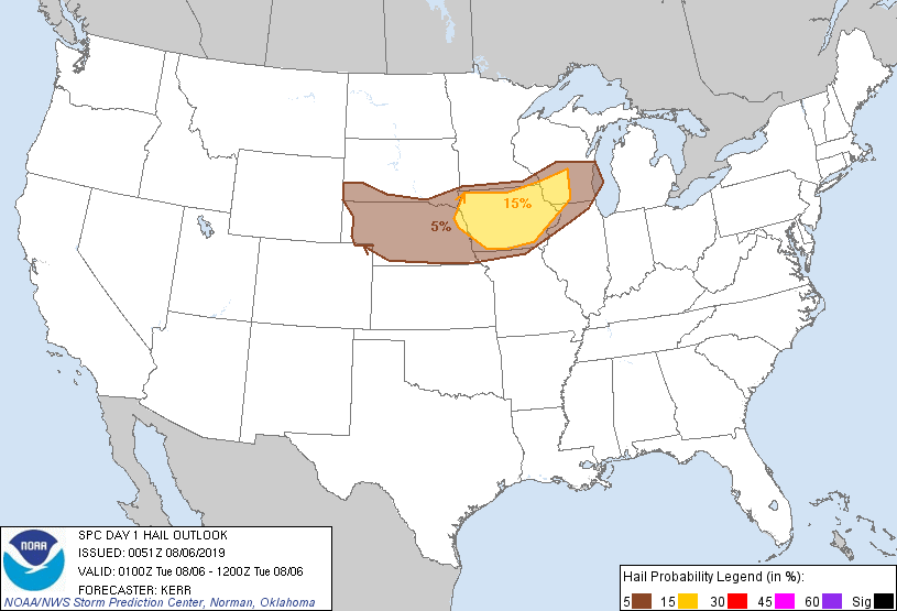 |
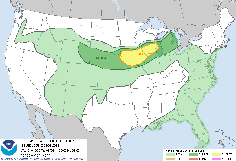
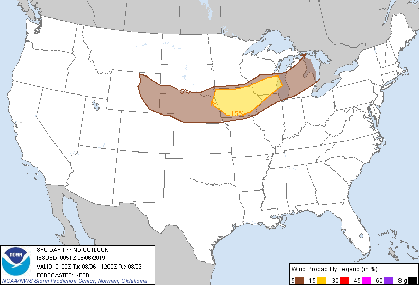
| Figure 1: Outlook | Figure 2: Tornado Outlook | Figure 3: Wind Outlook | Figure 4: Hail Outlook |
Near-storm environment summary.
 |
 |
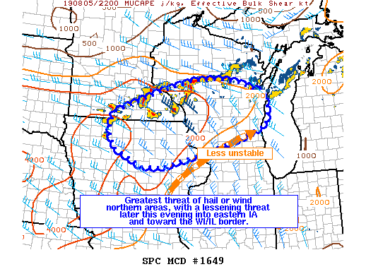
| Figure 4: MCD | Figure 5: DVN 7PM SOUNDING |
Additional environmental data.
 |
 |
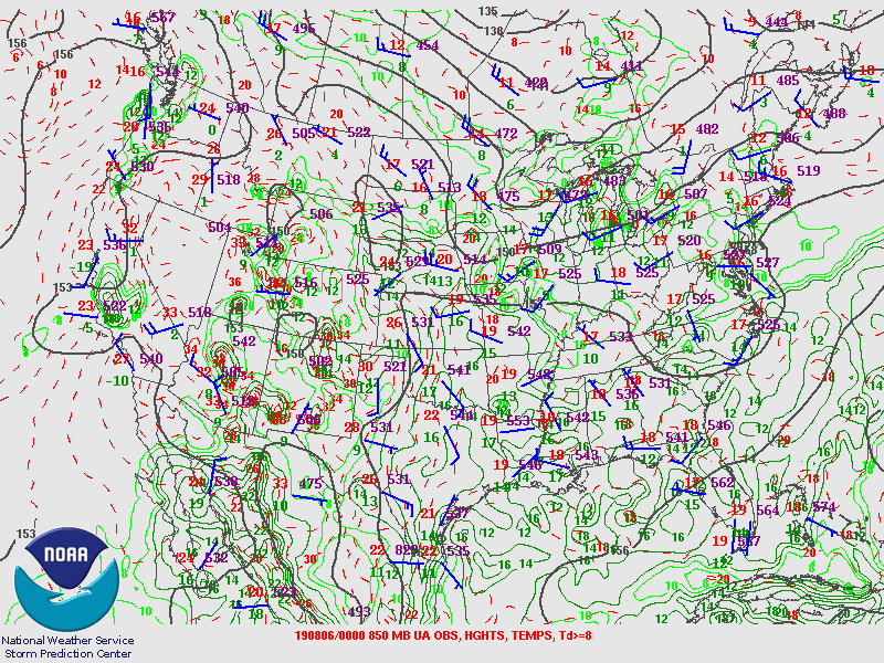 |
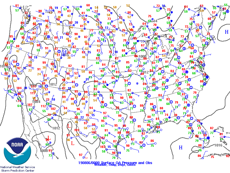
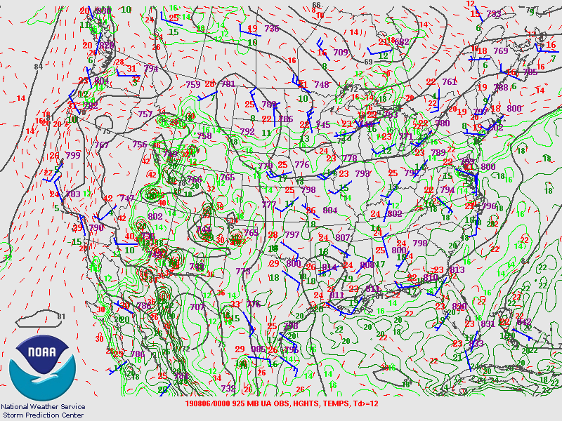
| Figure 6: surface | Figure 7: 925mb | Figure 8: 850mb |
 |
 |
 |
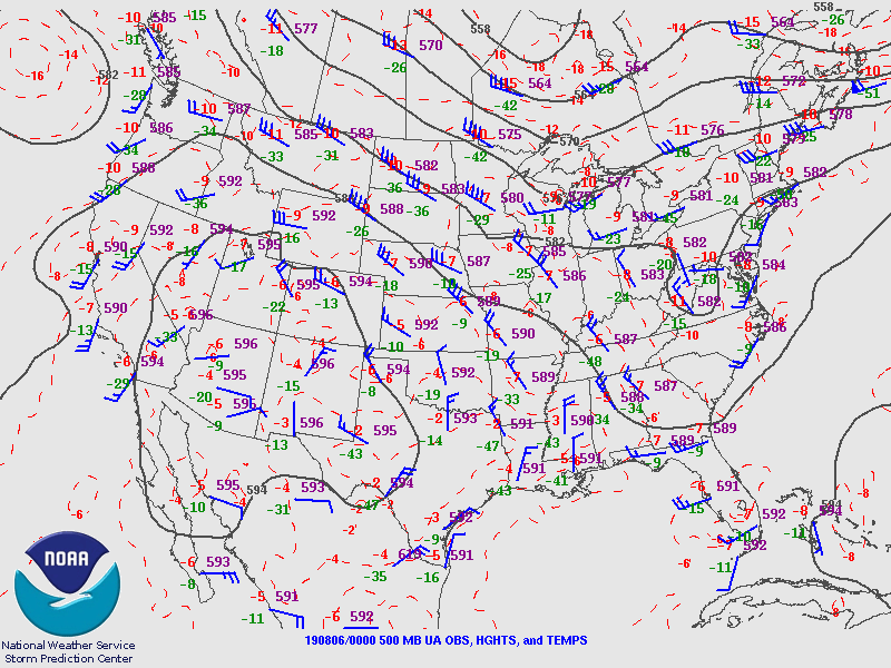
| Figure 9: 700mb | Figure 10: 500mb | Figure 11: 300mb |
 |
Media use of NWS Web News Stories is encouraged! Please acknowledge the NWS as the source of any news information accessed from this site. |
|