Dangerous heat will expand from the Gulf Coast into the Southern Plains and Desert Southwest through week's end. Additional extreme heat impacting the Pacific Northwest will shift to the northern Plains by the weekend. Tropical Storm Bertha is expected to continue to impact portions of the northern Gulf Coast from the western Florida Panhandle to southeastern Louisiana through tonight. Read More >
Overview
|
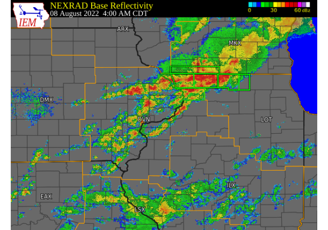
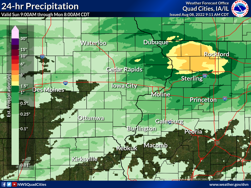
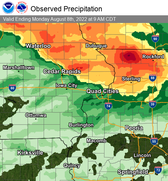
Two rounds of showers and thunderstorms tracked across northeast Iowa and northern Illinois Sunday morning and early Monday morning bringing torrential rain and occasional lightning to the region. Rainfall amounts over 2 inches were common northeast of a line from Cedar Rapids, to De Witt, to Prophetstown IL. The highest amounts between 5 and 11 inches fell in eastern Jo Daviess and Stephenson counties in northwest IL. This caused numerous road closures in the county and floodwaters impacting homes in Freeport, IL. |
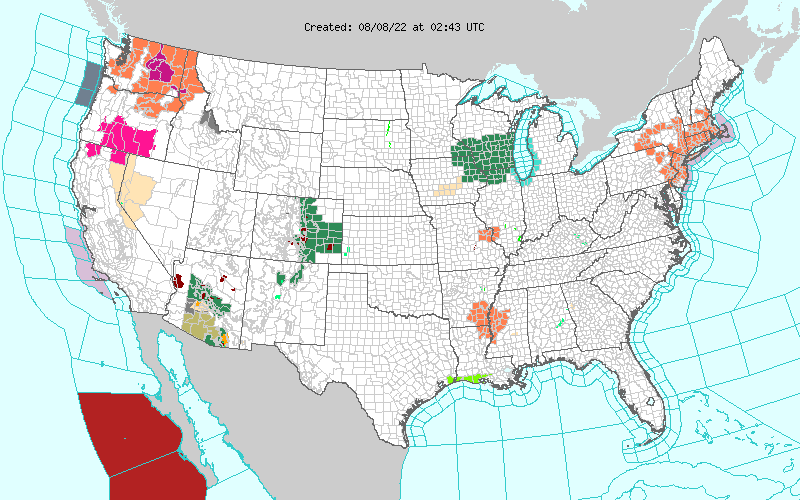 Watch, Warning Map 943pm August 7th |
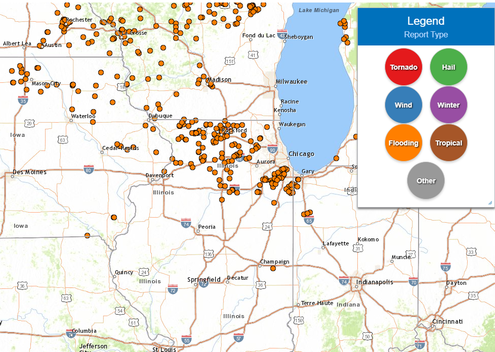
Storm Reports
 |
PRELIMINARY LOCAL STORM REPORT...SUMMARY
NATIONAL WEATHER SERVICE QUAD CITIES IA IL
1136 AM CDT MON AUG 8 2022

..TIME...   ...EVENT...      ...CITY LOCATION...     ...LAT.LON...
..DATE...   ....MAG....      ..COUNTY LOCATION..ST.. ...SOURCE....
            ..REMARKS..

1200 PM     HEAVY RAIN       STONE CITY              42.11N 91.35W
08/07/2022  M6.80 INCH       JONES              IA   PUBLIC

            6.8 INCHES THROUGH NOON. RAIN HAS STOPPED.

1201 PM     HEAVY RAIN       1 E ONECO               42.49N 89.65W
08/07/2022  E8.00 INCH       STEPHENSON         IL   PUBLIC

            PHOTO RECEIVED VIA TWITTER OF APPROXIMATELY
            8.00 INCHES OF RAIN IN A GAUGE JUST INSIDE
            THE WISCONSIN STATE LINE NEAR ORANGEVILLE,
            IL.

1240 PM     HEAVY RAIN       4 N STOCKTON            42.41N 90.00W
08/07/2022  M4.24 INCH       JO DAVIESS         IL   CO-OP OBSERVER

            0.57 INCHES ADDITIONAL RAIN SINCE 7 AM.
            STORM TOTAL 4.24 INCHES.

0301 PM     HEAVY RAIN       1 W MORRISON            41.81N 89.98W
08/07/2022  M3.65 INCH       WHITESIDE          IL   TRAINED SPOTTER

            RAINFALL IN THE PAST 12 HOURS.

0500 PM     HEAVY RAIN       WYOMING                 42.06N 91.00W
08/07/2022  M3.50 INCH       JONES              IA   TRAINED SPOTTER

            RAINFALL LAST NIGHT AND THIS MORNING.

0528 PM     HEAVY RAIN       2 SW WHITESIDE COUNTY A 41.73N 89.71W
08/07/2022  M3.12 INCH       WHITESIDE          IL   TRAINED SPOTTER

            RAINFALL LAST NIGHT AND THIS MORNING.

0705 PM     HEAVY RAIN       3 ENE GARDEN PLAIN      41.81N 90.08W
08/07/2022  M4.10 INCH       WHITESIDE          IL   TRAINED SPOTTER

            RAINFALL LAST NIGHT AND THIS MORNING.

0706 PM     HEAVY RAIN       2 SW SAINT DONATUS      42.35N 90.57W
08/07/2022  M1.95 INCH       JACKSON            IA   TRAINED SPOTTER

            RAINFALL LAST NIGHT AND THIS MORNING.

0800 PM     HEAVY RAIN       4 SE LORAN              42.18N 89.87W
08/07/2022  M3.40 INCH       CARROLL            IL   TRAINED SPOTTER

            RAINFALL FROM LAST NIGHT AND THIS MORNING.

0846 PM     HEAVY RAIN       2 WNW CHARLOTTE         41.98N 90.50W
08/07/2022  M2.34 INCH       CLINTON            IA   TRAINED SPOTTER

            RAINFALL LAST NIGHT AND THIS MORNING.

0921 PM     HEAVY RAIN       1 SSW CORDOVA           41.67N 90.33W
08/07/2022  M1.50 INCH       ROCK ISLAND        IL   TRAINED SPOTTER

            RAINFALL FROM LAST NIGHT AND THIS MORNING.

0510 AM     FLASH FLOOD      2 NE LENA               42.40N 89.80W
08/08/2022                   STEPHENSON         IL   LAW ENFORCEMENT

            WATER OVER HIGHWAY 73 NEAR TORKELSON CHEESE
            COMPANY.

0539 AM     HEAVY RAIN       3 N STOCKTON            42.40N 90.00W
08/08/2022  M3.35 INCH       JO DAVIESS         IL   CO-OP OBSERVER

            OVERNIGHT RAINFALL. TWO DAY TOTAL OF 7.59
            INCHES.

0545 AM     FLASH FLOOD      FREEPORT                42.29N 89.63W
08/08/2022                   STEPHENSON         IL   EMERGENCY MNGR

            FLOODED ROADWAYS WITH WATER OVER THE FIRE
            HYDRANTS ON SOME STREETS IN THE NORTHWEST
            SIDE OF THE CITY.

0600 AM     HEAVY RAIN       2 ESE FAIRVIEW          42.08N 91.30W
08/08/2022  M3.40 INCH       JONES              IA   CO-OP OBSERVER

            CO-OP OBSERVER STATION AMOI4 ANAMOSA 3 SSW.

0600 AM     FLASH FLOOD      2 S MC CONNELL          42.40N 89.74W
08/08/2022                   STEPHENSON         IL   TRAINED SPOTTER

            DELAYED REPORT AND TIME ESTIMATED BY RADAR.
            ROAD WASHED OUT WITH DEEP WATER. RELAYED BY
            SOCIAL MEDIA. ROAD HAS YET TO BE CLOSED, BUT
            IT IS IMPASSABLE.

0625 AM     FLASH FLOOD      1 NW WADDAMS GROVE      42.43N 89.91W
08/08/2022                   STEPHENSON         IL   PUBLIC

            INTERSECTION OF BAKER RD AND GALENA RD
            FLOODED. DISCOVERED AND REPORTED VIA SOCIAL
            MEDIA BUT ROAD WAS LIKELY FLOODED EARLIER.

0628 AM     HEAVY RAIN       3 NNE BOLTON            42.29N 89.72W
08/08/2022  M4.91 INCH       STEPHENSON         IL   COCORAHS

            COCORAHS STATION IL-SP-28 FREEPORT 4.3 W.

0634 AM     HEAVY RAIN       3 N STOCKTON            42.40N 90.00W
08/08/2022  M3.58 INCH       JO DAVIESS         IL   CO-OP OBSERVER

            UPDATED RAINFALL FROM OVERNIGHT.

0650 AM     HEAVY RAIN       2 NW FREEPORT           42.30N 89.66W
08/08/2022  M5.72 INCH       STEPHENSON         IL   COCORAHS

            COCORAHS STATION IL-SP-25 FREEPORT 1.7 NW.

0654 AM     HEAVY RAIN       5 SE LORAN              42.18N 89.85W
08/08/2022  M3.18 INCH       CARROLL            IL   COCORAHS

            COCORAHS STATION IL-CR-20 LANARK 5.3 N.

0700 AM     HEAVY RAIN       1 E FREEPORT            42.29N 89.61W
08/08/2022  M6.00 INCH       STEPHENSON         IL   COCORAHS

            COCORAHS STATION IL-SP-22 FREEPORT 1.2 E.

0700 AM     HEAVY RAIN       1 E FREEPORT            42.29N 89.61W
08/08/2022  M4.88 INCH       STEPHENSON         IL   COCORAHS

            COCORAHS STATION IL-SP-29 1 E FREEPORT.

0700 AM     HEAVY RAIN       3 NNE STOCKTON          42.40N 89.99W
08/08/2022  M3.98 INCH       JO DAVIESS         IL   COCORAHS

            COCORAHS STATION IL-JD-8 STOCKTON 3.4 NNE.

0700 AM     HEAVY RAIN       3 NNE MC CONNELL        42.47N 89.72W
08/08/2022  M3.96 INCH       STEPHENSON         IL   COCORAHS

            COCORAHS STATION IL-SP-8 WINSLOW 4.3 ESE.

0700 AM     HEAVY RAIN       DAVIS                   42.43N 89.42W
08/08/2022  M3.72 INCH       STEPHENSON         IL   COCORAHS

            COCORAHS STATION IL-SP-7 DAVIS 0.5 N.

0700 AM     HEAVY RAIN       2 SSE ANAMOSA           42.08N 91.27W
08/08/2022  M3.29 INCH       JONES              IA   MESONET

            MESONET STATION ANSI4 WAPSIPINICON RIVER


0715 AM     HEAVY RAIN       6 SSE ELMOVILLE         42.19N 90.02W
08/08/2022  M3.43 INCH       CARROLL            IL   COCORAHS

            COCORAHS STATION IL-CR-12 MOUNT CARROLL 6.8
            NNW.

0720 AM     HEAVY RAIN       RIDOTT                  42.30N 89.48W
08/08/2022  M4.42 INCH       STEPHENSON         IL   COCORAHS

            COCORAHS STATION IL-SP-21 RIDOTT 0.1 NE.

0728 AM     HEAVY RAIN       1 E FREEPORT            42.29N 89.61W
08/08/2022  M6.00 INCH       STEPHENSON         IL   TRAINED SPOTTER


0731 AM     HEAVY RAIN       2 WSW LORAN             42.22N 89.95W
08/08/2022  M4.19 INCH       JO DAVIESS         IL   MESONET

            MESONET STATION FW6589 MOUNT CARROLL.

0806 AM     HEAVY RAIN       3 NNE STOCKTON          42.40N 89.99W
08/08/2022  M3.66 INCH       JO DAVIESS         IL   MESONET

            MESONET STATION EW8497 STOCKTON.

0830 AM     HEAVY RAIN       DAVIS                   42.42N 89.41W
08/08/2022  M6.40 INCH       STEPHENSON         IL   TRAINED SPOTTER

            RAINFALL FROM OVERNIGHT.

0834 AM     HEAVY RAIN       NORA                    42.46N 89.94W
08/08/2022  M6.50 INCH       JO DAVIESS         IL   TRAINED SPOTTER

            48 HOUR RAINFALL TOTAL.

0900 AM     FLASH FLOOD      MC CONNELL              42.43N 89.73W
08/08/2022                   STEPHENSON         IL   PUBLIC

            LOCATION AND TIME ESTIMATED OFF OF A SOCIAL
            MEDIA REPORT. REPORT AND PICTURE INDICATE
            THAT FLASH FLOODING CAUSED A HOMES
            FOUNDATION TO CAVE IN, WITH WATER GETTING
            INTO THE HOUSE.

0909 AM     HEAVY RAIN       1 W MORRISON            41.81N 89.98W
08/08/2022  M5.55 INCH       WHITESIDE          IL   TRAINED SPOTTER

            24 HOUR RAINFALL TOTAL.

1039 AM     HEAVY RAIN       1 WSW NEW LONDON        40.92N 91.43W
08/08/2022  E3.50 INCH       HENRY              IA   TRAINED SPOTTER

            RAINFALL SINCE 415 AM.

1039 AM     HEAVY RAIN       3 W MOUNT STERLING      40.62N 92.00W
08/08/2022  M1.40 INCH       VAN BUREN          IA   TRAINED SPOTTER

            RAINFALL IN THE LAST 24 HOURS.

1105 AM     HEAVY RAIN       NEW LONDON              40.92N 91.41W
08/08/2022  M4.90 INCH       HENRY              IA   TRAINED SPOTTER

            24 HOUR RAINFALL TOTAL.

1108 AM     HEAVY RAIN       2 WSW FREEPORT          42.28N 89.67W
08/08/2022  M9.90 INCH       STEPHENSON         IL   TRAINED SPOTTER

            48 HOUR TOTAL. 4.5 INCHES FROM OVERNIGHT
            STORMS.

1110 AM     HEAVY RAIN       1 E GERMAN VALLEY       42.22N 89.47W
08/08/2022  M4.08 INCH       STEPHENSON         IL   PUBLIC

            24 HOUR RAINFALL TOTAL. 3.71 INCHES SINCE
            4AM TODAY.
Rain Reports
| 24-Hr Rainfall Ending 08/07 around 9am | 24-Hr Rainfall Ending 08/08 around 9am | 48-Hr Regional Rainfall (reports here) |
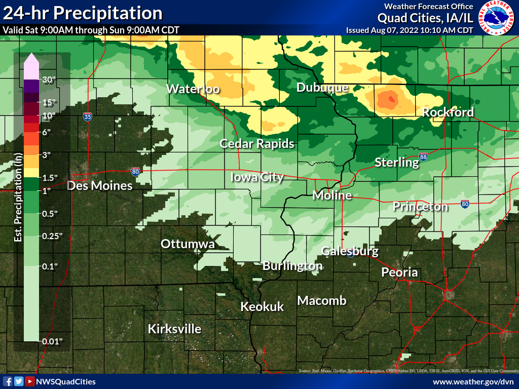 |
 |
 |
24 hour precipitation reports (in Inches), for eastern Iowa, northwest and west central Illinois, and northeast Missouri. Reported between Midnight and 9 AM, Sunday August 07, 2022. ....IOWA.... Independence 0.9 WNW 4.31 Mason City ASOS 6 W 3.80 Mason City 1 NNE 3.70 Central City 6.7 W 3.03 Fayette 1 NW 2.70 Oelwein AWOS 2.46 Hopkinton 5.4 WSW 2.17 Dubuque #3 7 SW 2.10 Anamosa 3 SSW 2.08 Elkader 6SSW 2.00 Waterloo ASOS 5 NW 1.95 Dubuque Arpt 1.34 Waukon 4SSE 1.26 Charlotte 1.9 WNW 1.14 Center Point 0.6 NNW 1.03 Maquoketa 1.00 Asbury 0.4 SW 0.78 Bellevue LD12 0.78 Guttenberg Dam 10 0.77 Dubuque LD11 0.69 Marion 1.7 NNW 0.51 Camanche 1.2 W 0.50 Palo 4.4 SSW 0.45 De Witt 0.40 Cedar Rapids Arpt 0.15 Marengo 3.6 N 0.10 Fairfax 4.0 NW 0.06 Lowden 0.06 Muscatine 2N 0.06 Grinnell AWOS 2 SSW 0.04 Davenport 0.9 WNW 0.03 Grinnell 2 SW 0.03 North Liberty 0.7 SSW 0.02 Cedar Rapids 2.7 NE 0.02 Davenport Arpt 0.02 Marengo 0.02 Wellman 4.0 E 0.00 Le Claire 1.8 NNE 0.00 Williamsburg 0.00 Washington 0.00 Fort Madison 0.9 NE 0.00 Burlington 6.5 SSW 0.00 Wapello 0.2 S 0.00 Ainsworth 7.4 N 0.00 Solon 0.3 ESE 0.00 Parnell 0.1 SSW 0.00 Oskaloosa AWOS 9 ESE 0.00 Toledo 3 N 0.00 Rathbun Reservoir 2 N 0.00 Ottumwa ASOS 6 NNW 0.00 Mt Pleasant 1 SSW 0.00 Marshalltown ASOS 4 N 0.00 Sigourney 0.00 Newton 1 NE 0.00 Pella 4 N 0.00 Pella AWOS 2 WSW 0.00 Donnellson 0.00 Keokuk LD19 0.00 Marshalltown 1 NW 0.00 Burlington Arpt 0.00 Iowa City Arpt 0.00 NWS Johnston* 5 NNW 0.00 Allerton 2 S 0.00 Iowa City 0.00 ....ILLINOIS.... Freeport 1.7 NW 4.91 Winslow 4.3 ESE 4.55 Freeport 4.42 Freeport 2.9 WSW 4.23 Stockton 3.4 NNE 3.55 Rockford Arpt 1.84 Davis 0.5 N 1.78 Elizabeth 1.75 Fulton LD13 1.67 Lanark 5.3 N 1.65 Sterling 4.9 WSW 1.05 Mount Carroll 6.8 NNW 0.67 Hanover 0.2 NW 0.53 Rochelle Arpt 0.33 Mundelein 0.18 Steward 0.17 Paw Paw 1 E 0.05 Quad City Arpt 0.01 Romeoville 0.00 Colchester 3.5 NE 0.00 Dallas City 3.0 SSE 0.00 Princeton 1.1 SE 0.00 Coal Valley 1.9 SE 0.00 Princeton 0.00 Tuscola 0.00 La Harpe 0.00 Ill. City LD16 3 WNW 0.00 Minonk 0.00 New Boston LD17 0.00 Decatur Airport 0.00 Augusta 0.00 Bloomington Airport 0.00 Windsor 0.00 Ogden 0.00 Lincoln NWS 0.00 Kewanee 1 E 0.00 St Anne 0.00 Galesburg 0.00 Gladstone LD18 0.00 Quincy Arpt 0.00 Peoria Arpt 0.00 Altona 0.00 Joliet Arpt 0.00 Aledo 0.00 ....MISSOURI.... Chillicothe Arpt 0.00 Kirksville Arpt 0.00 Columbia Arpt 0.00 ....WISCONSIN.... Viroqua 2.35 Darlington 2.10 Madison Arpt 1.65 Prairie du Chien AWOS 1.64 Whitewater 1.23 Monroe 1 W 1.05 Steuben 4SE 3 NE 0.96 Delavan-1 W-WWTP 1 W 0.79 Brodhead 1 SW 0.70 Sullivan-NWS 2 SE 0.70 Watertown-Arpt 0.66 Beloit-College 0.47 La Crosse WFO 0.40 Allenton-WWTP .6 NW 0.40 ....MINNESOTA.... Theilman 1SSW 0.18 |
24 hour precipitation reports (in Inches), for eastern Iowa, northwest and west central Illinois, and northeast Missouri. Reported between Midnight and 9 AM, Monday August 08, 2022. ....IOWA.... Anamosa 3 SSW 3.40 Bellevue LD12 2.80 Camanche 1.2 W 2.58 Charlotte 1.9 WNW 2.56 Guttenberg Dam 10 1.92 Dubuque Arpt 1.88 De Witt 1.85 Dubuque #3 7 SW 1.63 Lowden 1.57 Oelwein AWOS 1.45 Park View 0.2 WSW 1.35 Fayette 1 NW 1.35 Elkader 6SSW 1.20 Cedar Rapids 2.7 NE 1.16 Center Junction 2.6 W 1.12 Dubuque LD11 1.05 Le Claire 1.8 NNE 0.96 Manchester 0.95 Davenport Arpt 0.94 Independence 0.9 WNW 0.92 Eldridge 0.6 S 0.70 Waukon 4SSE 0.67 Davenport 0.9 WNW 0.66 Le Claire LD14 0.60 Hopkinton 5.4 WSW 0.57 Marengo 0.57 Marion 1.7 NNW 0.53 Wapello 5.4 SE 0.48 Monticello 1 E 0.46 Muscatine 2.1 N 0.43 Muscatine 2N 0.43 Iowa City 0.35 New London 1.5 SW 0.32 Fairfax 4.0 NW 0.32 Columbus Jct 2 SSW 0.32 Waterloo ASOS 5 NW 0.31 Mason City 1 NNE 0.28 Solon 0.3 ESE 0.25 Mason City ASOS 6 W 0.25 Mount Auburn 2.2 NNW 0.23 Belle Plaine 0.23 Fairfield 0.22 Washington 0.22 Iowa City Arpt 0.22 West Liberty 0.7 NNW 0.21 NWS Johnston* 5 NNW 0.20 Riverdale 0.5 N 0.19 Cedar Rapids Arpt 0.18 Marshalltown ASOS 4 N 0.18 Mt Pleasant 1 SSW 0.17 Centerville 0 NE 0.16 Washington 5.8 SW 0.14 Toledo 3 N 0.13 Marengo 3.6 N 0.12 Wapello 4.7 N 0.10 Rathbun Reservoir 2 N 0.10 Newton 1 NE 0.10 Marshalltown 1 NW 0.10 Burlington Arpt 0.10 Central City 6.7 W 0.09 Ely 0.5 SE 0.09 Donnellson 0.08 Vinton 0.08 Wellman 4.0 E 0.06 Hampton 1 N 0.06 Salem 1S 0.06 Marengo 2.6 SSW 0.04 Boone 1 SSW 0.04 Burlington 6.5 SSW 0.02 Ainsworth 7.4 N 0.02 Oskaloosa AWOS 9 ESE 0.02 Grinnell 2 SW 0.01 Ottumwa ASOS 6 NNW 0.00 Parnell 0.1 SSW 0.00 Grinnell AWOS 2 SSW 0.00 Pella 4 N 0.00 Pella AWOS 2 WSW 0.00 Keokuk LD19 0.00 ....ILLINOIS.... Freeport 1.2 E 6.00 Freeport 1.7 NW 5.72 Ridott 0.1 NE 4.42 Stockton 3.4 NNE 3.98 Winslow 4.3 ESE 3.96 Davis 0.5 N 3.72 Rockford Arpt 3.61 Mount Carroll 6.8 NNW 3.43 Lanark 5.3 N 3.18 Elizabeth 2.97 Fulton LD13 2.77 Rochelle Arpt 2.71 Coleta 1.4 SSW 2.47 Mendota 2 SE 2.38 Steward 2.24 Morrison 3.2 E 2.10 Mount Carroll 1.87 Ottawa 4 SW 1.60 Walnut 5.3 ENE 1.47 Joliet Arpt 1.33 Princeton 1.1 SE 1.30 Princeton 1.30 Paw Paw 1 E 1.29 Alexis 1 SW 1.20 Coal Valley 2.6 E 1.07 Mundelein 0.95 Prophetstown 0.2 SW 0.92 Quad City Arpt 0.75 Romeoville 0.73 Ill. City LD16 3 WNW 0.64 Moline 0.7 NNE 0.62 Kewanee 1 E 0.56 New Boston LD17 0.47 Coal Valley 1.9 SE 0.40 Aledo 0.37 Gladstone LD18 0.33 Streator 3 SE 0.19 St Anne 0.10 Galva 2.7 NE 0.08 Stronghurst 0.4 SSW 0.00 La Harpe 0.00 Bloomington Airport 0.00 Colchester 3.5 NE 0.00 Warsaw 5.8 SE 0.00 Dallas City 3.0 SSE 0.00 Jacksonville Arpt 0.00 Decatur Airport 0.00 Augusta 0.00 Lincoln NWS 0.00 Quincy Arpt 0.00 Peoria Arpt 0.00 ....MISSOURI.... Memphis 0.10 Kirksville Arpt 0.01 Kahoka 0.6 S 0.00 Chillicothe Arpt 0.00 Columbia Arpt 0.00 ....WISCONSIN.... Darlington 1.51 Brodhead 1 SW 1.22 Prairie du Chien AWOS 1.07 Beloit-College 1.03 La Crosse WFO 0.52 Viroqua 0.51 Madison Arpt 0.48 Watertown-Arpt 0.22 Sullivan-NWS 2 SE 0.18 Whitewater 0.15 ....MINNESOTA.... Theilman 1SSW 0.25 |
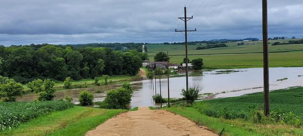
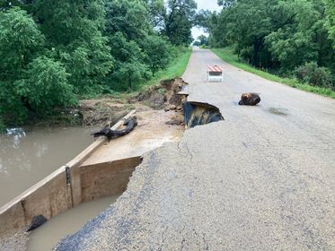
Photos & Video
Header
 |
 |
 |
 |
| Towline Rd Near Lena, IL Photo: Brandon McGrew |
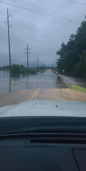
Near Eleroy, IL Photo: Brandon McGrew |
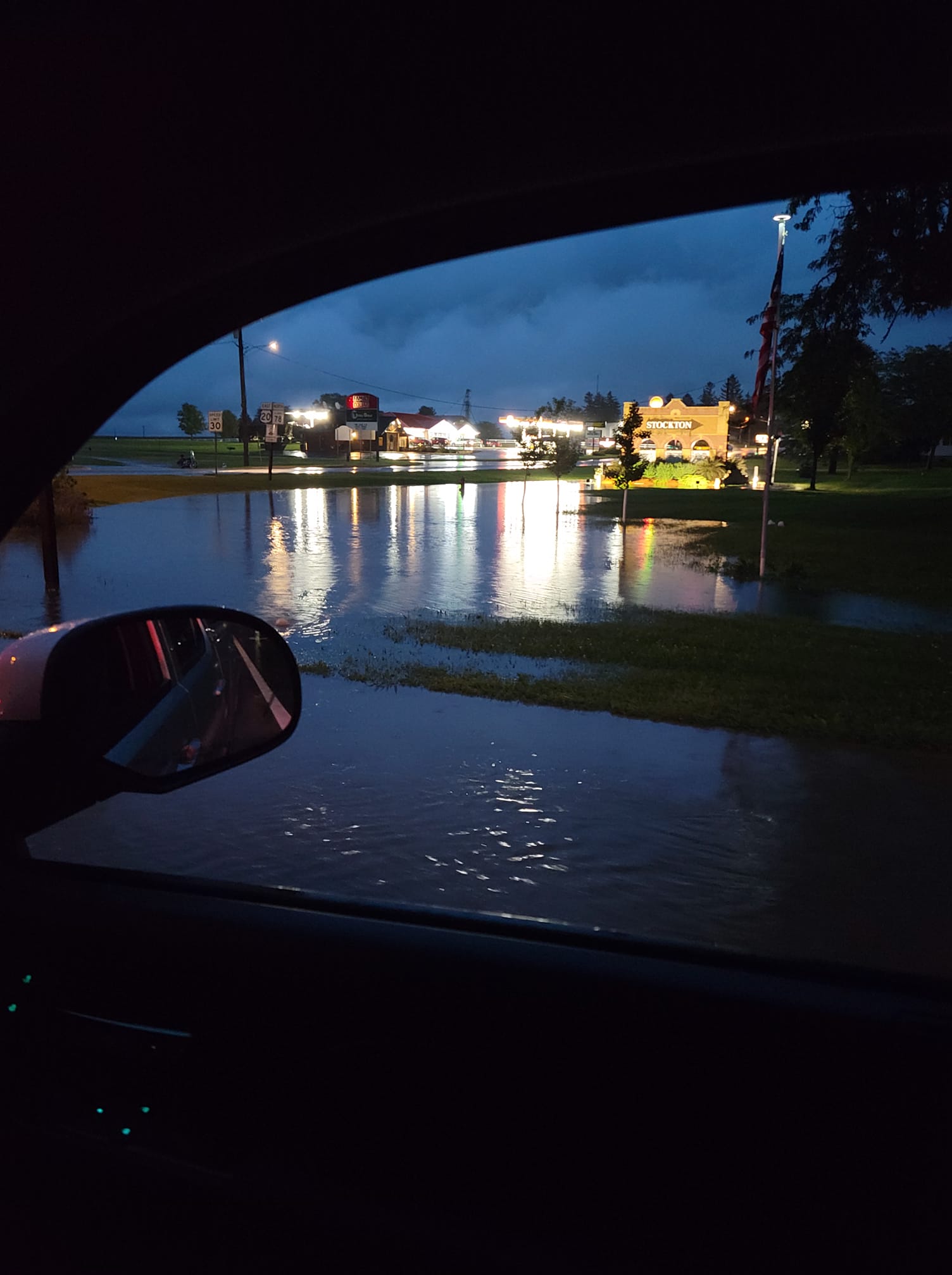
Stockton, IL Photo: Randy Baysinger |
Stagecoach Trail and Baker Rd Near Nora, IL Photo: Joe Sidor |
Environment
 |
 |
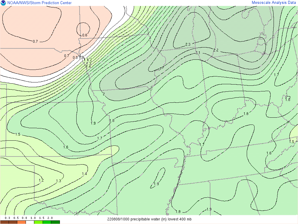 |
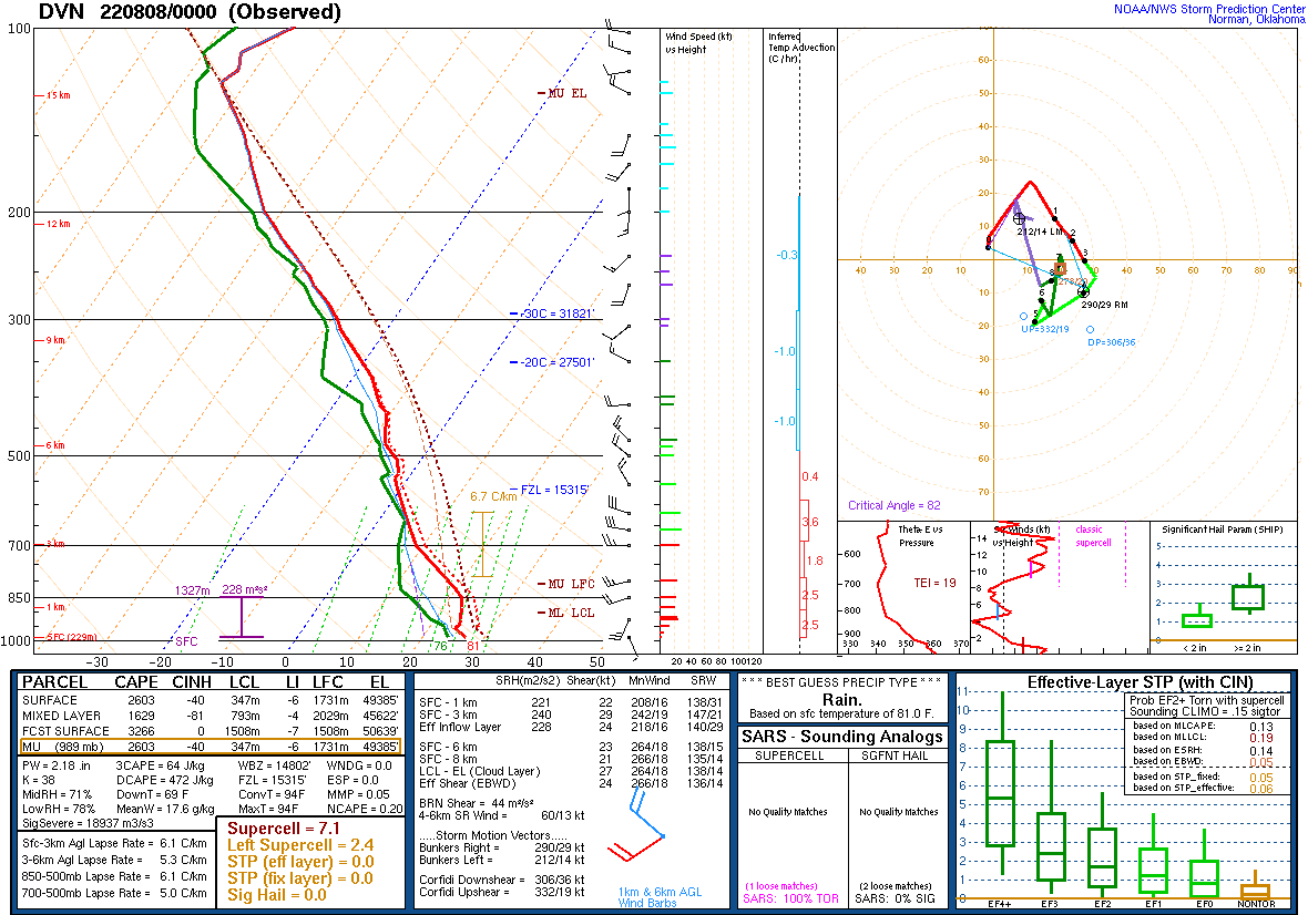
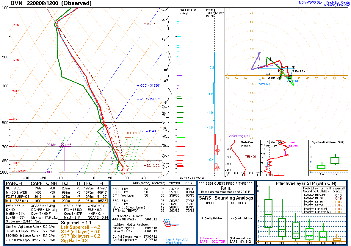
| Figure 1: 00z 08/08 DVN Sounding | Figure 2: 12z 08/08 DVN Sounding | Figure 3: 10z 08/08 Precipitable Water |
 |
 |
|
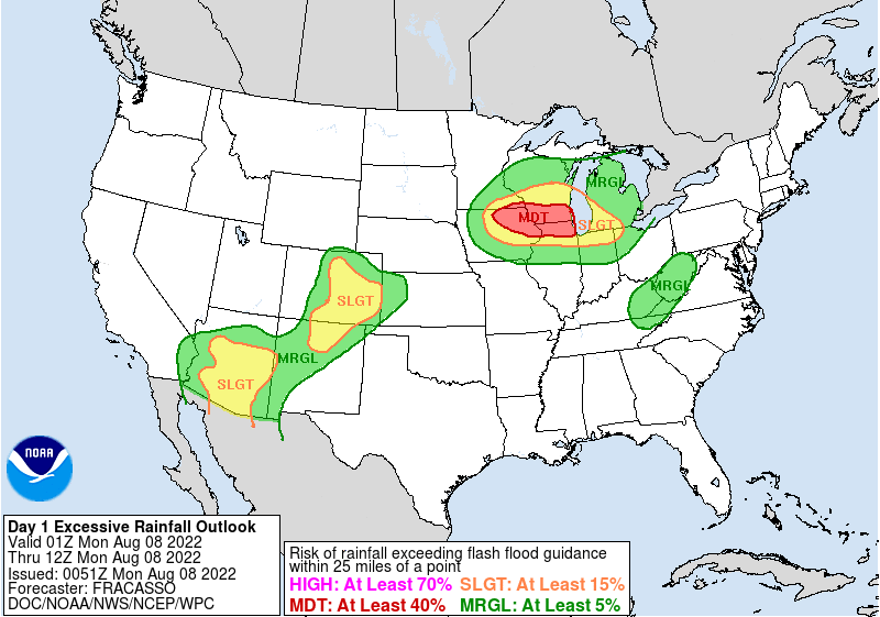
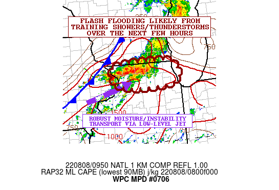
| Figure 4: WPC Excessive Rainfall Outlook 01z 08/08 | Figure 5: WPC Mesoscale Precipitation Discussion |
 |
Media use of NWS Web News Stories is encouraged! Please acknowledge the NWS as the source of any news information accessed from this site. |
|