Overview
|
Widespread showers and thunderstorms tracked across eastern Iowa, northwest Illinois and northeast Missouri ahead of a cold front during the afternoon and evening of Thursday, August 16. These storms mainly produced torrential rainfall amounts of 1-3 inches and frequent lightning. A tornado touched down on the west side of Oxford Junction, IA, which caused damage to a structure. |
Radar Loop (16 August 2018 - 2:00 PM - 10:00 PM) 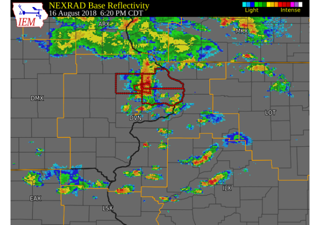 |
Tornado:
|
Tornado - Oxford Junction, IA
Track Map 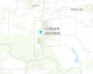  |
||||||||||||||||
This section will be completed soon!
|
|
| Local Rainfall Map | Radar Estimated Rainfall |
 |
 |
|
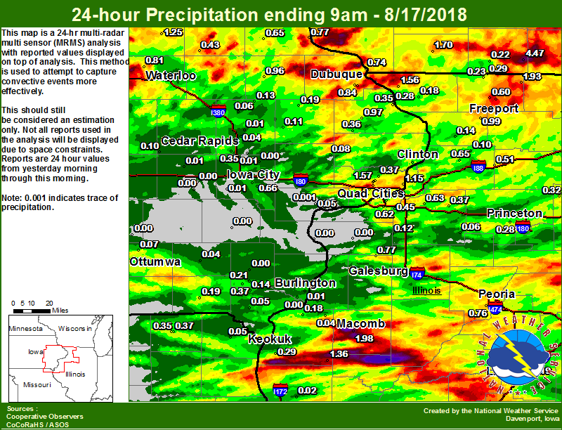
24 hour precipitation reports (in Inches), for eastern Iowa, northwest and west central Illinois, and northeast Missouri. Reported between Midnight and 9 AM, Friday August 17, 2018. ....IOWA.... Davenport Arpt 5 N 2.49 Dubuque Arpt 7 SW 1.84 Eldridge 0.6 S 1.67 Eldridge 0.7 SSW 1.57 Eldridge 0.6 ESE 1.42 Tripoli 0 N 1.25 Le Claire 1.8 NNE 1.15 Davenport 3.8 NNW 1.07 Davenport 2.9 W 0.98 Fulton 0.97 Manchester 0.96 Dubuque #3 7 SW 0.84 Waterloo ASOS 5 NW 0.81 Guttenberg Dam 10 0.77 Pella 4 N 0.76 Dubuque LD11 0.74 Bettendorf 1.6 WSW 0.72 Davenport 0.9 WNW 0.69 Ames US 30 2 SSE 0.66 Iowa City 0.66 Elkader 6SSW 0.65 Cresco 1 NE 0.58 Toledo 3 N 0.55 Mason City ASOS 6 W 0.52 Davenport 0.9 SSW 0.49 Mason City 1 NNE 0.48 Center Point 0.6 NNW 0.47 Camanche 1.2 W 0.44 Bettendorf 2.2 SE 0.43 Oelwein AWOS 0.43 Salem 1S 0.37 Park View 0.2 WSW 0.37 Maquoketa 4W 0.36 Cedar Rapids Arpt 5 SW 0.35 Bellevue 0.3 SSW 0.35 Iowa City Arpt 0.34 Bellevue LD12 0.28 Boone 1 SSW 0.21 Salem 3.1 ESE 0.21 Monticello 1 E 0.19 Keosauqua 0.19 Marshalltown 1 NW 0.16 West Point 7.5 NW 0.14 Coggon 0.13 Anamosa 3 SSW 0.11 Belle Plaine 0.10 Lowden 0.08 Ottumwa ASOS 6 NNW 0.07 Central City 6.7 W 0.06 Oskaloosa 1 NNW 0.06 Hampton 1 N 0.06 Donnellson 0.05 Cedar Rapids 2.7 NE 0.04 Grinnell 2 SW 0.04 Pella AWOS 2 WSW 0.04 Fairfield 0.04 Rathbun Reservoir 2 N 0.02 Ely 0.5 SE 0.01 Burlington Arpt 2 SW 0.01 Marion 1.7 NNW 0.01 Marengo 2.6 SSW 0.01 Kalona 7.3 NNW 0.01 Marshalltown ASOS 4 N 0.01 Muscatine 2N 0.00 Mt Pleasant 1 SSW 0.00 Beaconsfield 1 NNE 0.00 Oskaloosa AWOS 9 ESE 0.00 Washington 0.00 Burlington 6.5 SSW 0.00 Centerville 0 NE 0.00 NWS Johnston* 5 NNW 0.00 Perry 0 W 0.00 Parnell 0.1 SSW 0.00 Grinnell AWOS 2 SSW 0.00 Williamsburg 0.00 Solon 0.3 ESE 0.00 ....ILLINOIS.... Colchester 3.5 NE 1.98 Davis 0.5 N 1.93 Galena 1.56 Augusta 1.36 Shannon 0.2 S 0.99 Freeport 0.98 Bloomington Airport 0.92 Alexis 1 SW 0.77 Peoria ASOS 0.76 Roscoe 2SE 0.69 Morrison 3.2 E 0.65 Geneseo 2.0 NW 0.63 Quad City Arpt 3 S 0.62 Freeport 2.0 NW 0.60 Romeoville 0.54 Rochelle 0.54 Rock Falls 0.51 Ottawa 4 SW 0.50 Moline 0.9 N 0.45 Coal Valley 1.9 SE 0.45 Rochelle AWOS 0.44 Mundelein 0.43 Monmouth 4NW 0.39 Paw Paw 1 E 0.39 Steward 0.38 Rockford ASOS 0.37 Atkinson 2.6 NNE 0.37 Jacksonville AWOS 0.35 Mendota 2 SE 0.32 Joliet 0.29 Warsaw 5.8 SE 0.29 Orangeville 2.8 NW 0.29 Tiskilwa 2.1 N 0.28 Princeton 1.1 SE 0.24 Princeton 0.24 Winslow 4.3 ESE 0.23 Lincoln NWS 0.19 Dallas City 3.0 SSE 0.18 Elizabeth 0.18 St Anne 0.17 Chadwick 2.7 WSW 0.14 New Windsor 2.0 N 0.12 Streator 3 SE 0.10 Coleta 1.4 SSW 0.10 Galesburg Arpt 3 SW 0.07 Kewanee 1 E 0.06 Ill. City LD16 3 WNW 0.05 La Harpe 0.04 Quincy ASOS 0.02 Aledo 0.00 New Boston LD17 0.00 ....MISSOURI.... Memphis 0.1 S 0.37 Memphis 0.35 Columbia 0.06 Kahoka 0.6 S 0.05 Kirksville ASOS 0.00 Chillicothe 2 NW 0.00 ....WISCONSIN.... Brodhead 1 SW 4.47 Madison-ASOS 1.87 Darlington 1.70 Whitewater 1.34 Watertown-AWOS 1.08 Delavan-1 W-WWTP 1 W 0.88 La Crosse WFO 0.88 Beloit-College 0.80 Steuben 4SE 3 NE 0.64 Prairie du Chien AWOS 0.44 Monroe 1 W 0.22 Allenton-WWTP .6 NW 0.21 ....MINNESOTA.... Preston 0.27 |
|
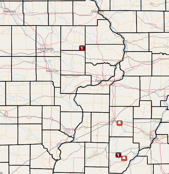
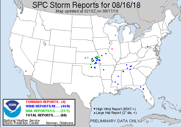
| Interactive Storm Report Map | SPC Storm Reports |
 |
 |
|
PRELIMINARY LOCAL STORM REPORTS
0608 PM TORNADO OXFORD JUNCTION 41.98N 90.96W 6 FIREFIGHTERS OBSERVED TORNADO TOUCHDOWN ON
24 HOUR STORM TOTAL RAINFALL. |
|
 |
 |
 |
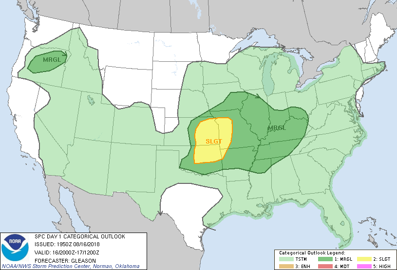
| Figure 1 SPC Day 1 Outlook 20:00 UTC) |
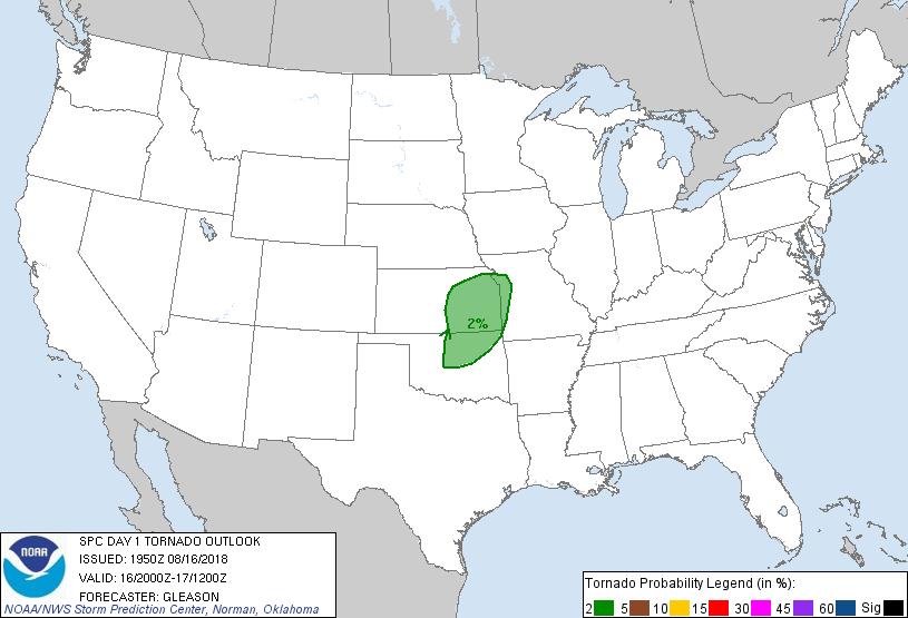
Figure 2 SPC Day 1 Tornado Outlook (20:00 UTC) |
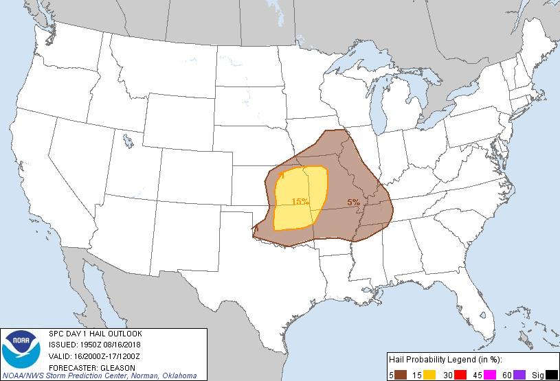
Figure 3 SPC Day 1 Hail Outlook (20:00 UTC) |
 |
 |
 |
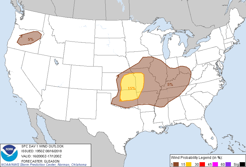
| Figure 4 SPC Day 1 Wind Outlook (20:00 UTC) |
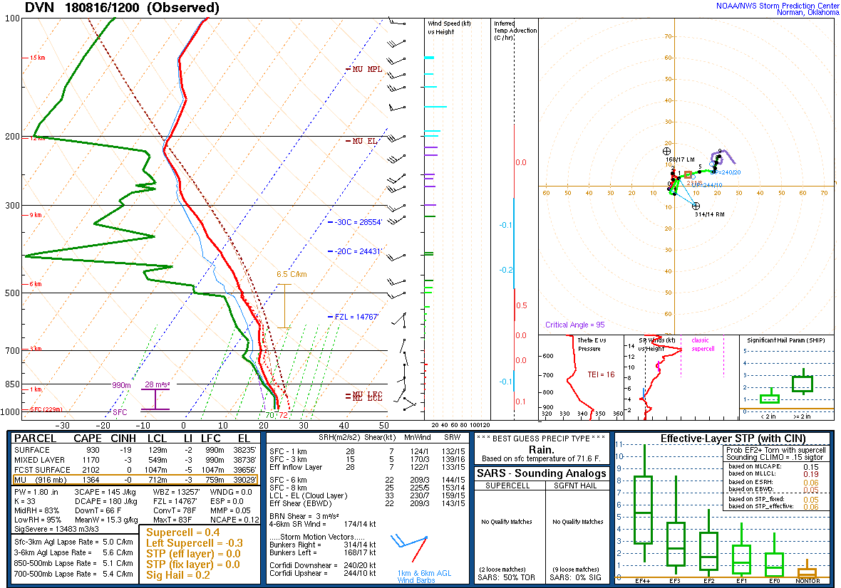
Figure 5 DVN Sounding 8/16/18 12z |
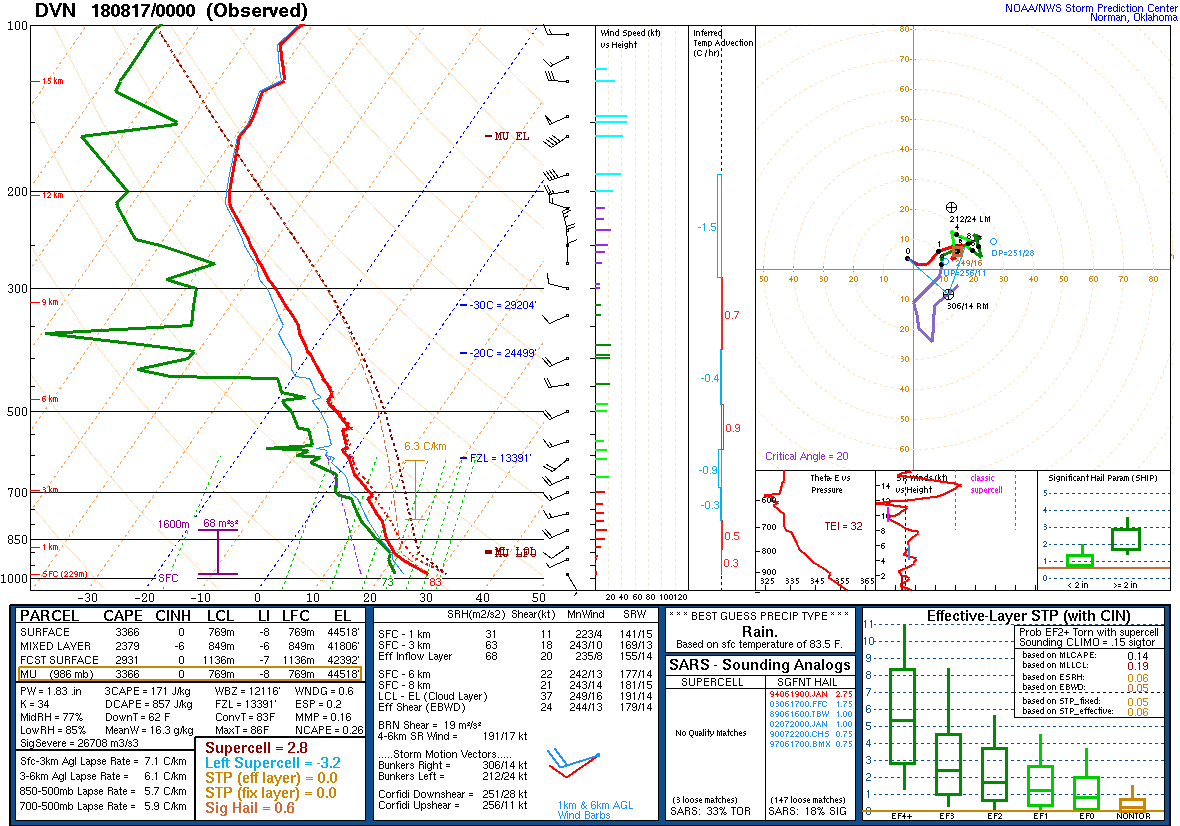
Figure 6 DVN Sounding 8/17/18 00z |
 |
Media use of NWS Web News Stories is encouraged! Please acknowledge the NWS as the source of any news information accessed from this site. |

