Scattered thunderstorms with severe gusts, hail and a tornado risk are possible near a cold front from the Ohio Valley to the Mid-Atlantic tonight. Tropical Storm Bertha is expected to bring tropical storm conditions to portions of the Gulf Coast from the panhandle of Florida into Louisiana through Wednesday. Read More >
Overview
|
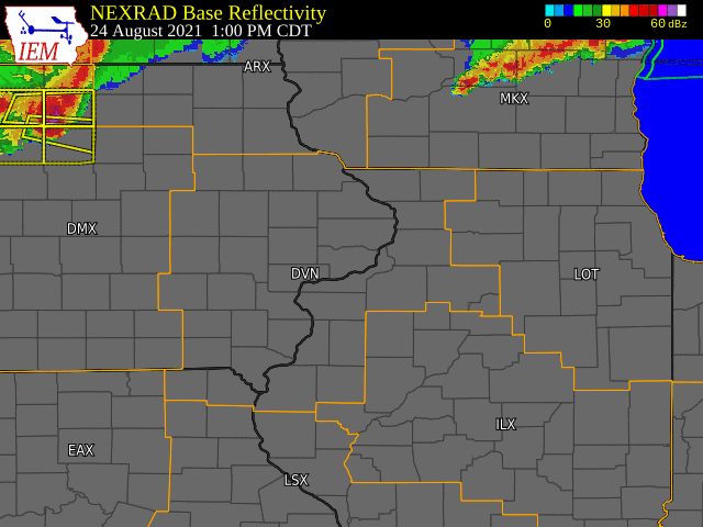
Severe thunderstorms developed across a good portion of eastern Iowa and northwest Illinois on the afternoon of Tuesday August 24th, 2021. A corridor of very strong winds was observed along the Highway 20 corridor from Fairbank IA, to Hazelton IA and to Manchester IA, where numerous reports of damage to trees, homes and power outages were received. Hail up to golf ball size was also observed in Manchester IA. Storms continued to track south and east, with an outflow boundary producing strong winds into portions of northwest Illinois including the Quad Cities metro. Additional reports of wind damage were received across northwest Illinois, with a 66 MPH wind gust measured at the Savanna, IL AWOS.
|
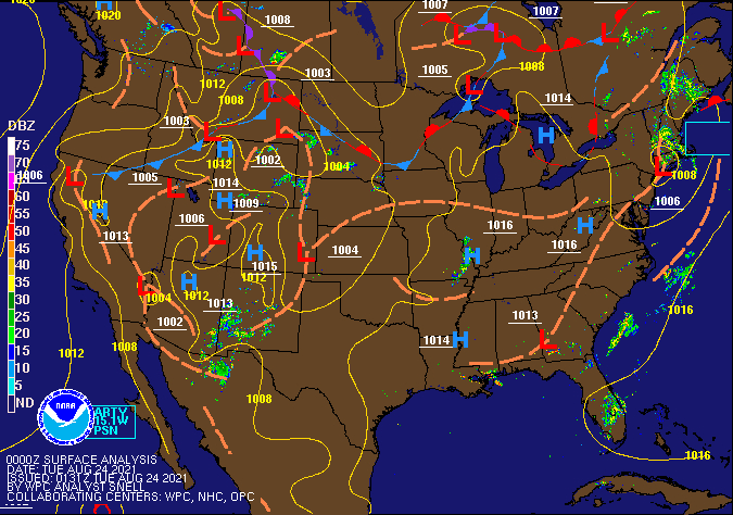
Surface Analysis Courtesy Weather Prediction Center (WPC) |
Storm Reports
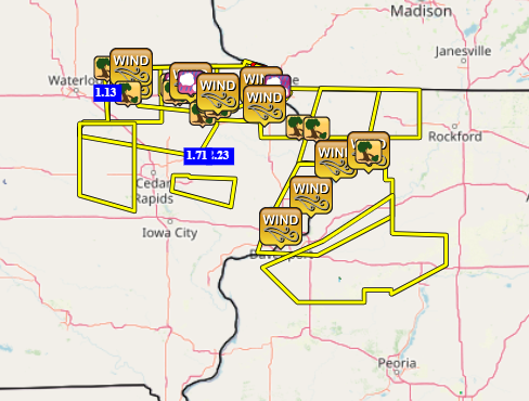
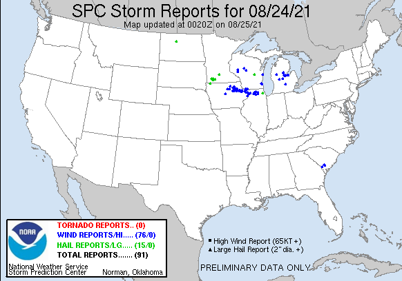
| Interactive Storm Report Map (IEM) | SPC Storm Reports |
 |
 |
PRELIMINARY LOCAL STORM REPORT...SUMMARY
NATIONAL WEATHER SERVICE QUAD CITIES IA IL
813 PM CDT TUE AUG 24 2021

..TIME...   ...EVENT...      ...CITY LOCATION...     ...LAT.LON...
..DATE...   ....MAG....      ..COUNTY LOCATION..ST.. ...SOURCE....
            ..REMARKS..

0250 PM     TSTM WND DMG     HAZLETON                42.62N 91.90W
08/24/2021                   BUCHANAN           IA   CO-OP OBSERVER

            2 LARGE TREES DOWN OVER THE ROAD WITH POWER
            LINES. TIME ESTIMATED FROM RADAR.

0250 PM     TSTM WND DMG     FAIRBANK                42.63N 92.06W
08/24/2021                   BUCHANAN           IA   TRAINED SPOTTER

            SEVERAL LARGE TREE LIMBS DOWN, TIME
            ESTIMATED FROM RADAR.

0250 PM     TSTM WND DMG     2 S HAZLETON            42.60N 91.90W
08/24/2021                   BUCHANAN           IA   TRAINED SPOTTER

            SEVERAL TREES UPROOTED SOUTH OF HAZELTON
            NEAR THE FONTANA TURNOFF.

0250 PM     TSTM WND GST     5 SSE HAZLETON          42.55N 91.86W
08/24/2021  E70 MPH          BUCHANAN           IA   TRAINED SPOTTER


0252 PM     TSTM WND GST     2 ENE HAZLETON          42.63N 91.86W
08/24/2021  M61 MPH          BUCHANAN           IA   CO-OP OBSERVER


0255 PM     TSTM WND DMG     INDEPENDENCE            42.47N 91.89W
08/24/2021                   BUCHANAN           IA   TRAINED SPOTTER

            LARGE 8-10 INCH DIAMETER BRANCH DOWN.

0319 PM     TSTM WND DMG     1 N MANCHESTER AIRPORT  42.52N 91.50W
08/24/2021                   DELAWARE           IA   EMERGENCY MNGR

            EM RELAYED REPORT OF A POLE BARN FLATTENED
            NORTHWEST OF MANCHESTER. TIME ESTIMATED FROM
            RADAR.

0325 PM     TSTM WND DMG     1 E MANCHESTER          42.48N 91.44W
08/24/2021                   DELAWARE           IA   EMERGENCY MNGR

            ROOF PEELED OFF DOWNTOWN BUILDING. ALSO
            SEVERAL TREES DOWN IN DOWNTOWN. TIME
            ESTIMATED FROM RADAR.

0326 PM     HAIL             3 NE MANCHESTER AIRPORT 42.53N 91.46W
08/24/2021  E1.75 INCH       DELAWARE           IA   FIRE DEPT/RESCUE

            TIME ESTIMATED RADAR.

0340 PM     TSTM WND DMG     1 W MANCHESTER          42.48N 91.48W
08/24/2021                   DELAWARE           IA   PUBLIC

            REPORT FROM MPING: TREES UPROOTED OR
            SNAPPED; ROOF BLOWN OFF.

0341 PM     TSTM WND GST     ONEIDA                  42.54N 91.35W
08/24/2021  E60 MPH          DELAWARE           IA   EMERGENCY MNGR


0344 PM     HAIL             ONEIDA                  42.54N 91.35W
08/24/2021  E0.70 INCH       DELAWARE           IA   EMERGENCY MNGR


0353 PM     TSTM WND DMG     HOPKINTON               42.34N 91.25W
08/24/2021                   DELAWARE           IA   TRAINED SPOTTER

            SEVERAL LARGE TREES DOWN IN TOWN, TIME
            ESTIMATED FROM RADAR.

0358 PM     TSTM WND GST     1 S DYERSVILLE          42.46N 91.12W
08/24/2021  E70 MPH          DUBUQUE            IA   EMERGENCY MNGR


0358 PM     HAIL             1 S DYERSVILLE          42.46N 91.12W
08/24/2021  M1.00 INCH       DUBUQUE            IA   EMERGENCY MNGR


0400 PM     HEAVY RAIN       JESUP                   42.48N 92.07W
08/24/2021  M1.13 INCH       BUCHANAN           IA   TRAINED SPOTTER

            RAIN FELL IN ABOUT A HALF HOUR.

0400 PM     TSTM WND DMG     WORTHINGTON             42.39N 91.12W
08/24/2021                   DUBUQUE            IA   TRAINED SPOTTER

            LARGE PINE TREE DOWN ACROSS ROAD NEAR TOWN,
            TIME ESTIMATED FROM RADAR.

0400 PM     TSTM WND GST     1 S DYERSVILLE          42.47N 91.12W
08/24/2021  M58 MPH          DUBUQUE            IA   FIRE DEPT/RESCUE

            MEASURED AT FIRE STATION.

0425 PM     TSTM WND GST     1 SE ASBURY             42.51N 90.75W
08/24/2021  E50 MPH          DUBUQUE            IA   TRAINED SPOTTER

            40 TO 50 MPH GUSTS ESTIMATED.

0428 PM     HAIL             2 NE EAST DUBUQUE       42.51N 90.61W
08/24/2021  E0.25 INCH       JO DAVIESS         IL   PUBLIC

            ESTIMATED WINDS 40-50 MPH.

0433 PM     HAIL             DUBUQUE REGIONAL ARPT   42.40N 90.72W
08/24/2021  M1.00 INCH       DUBUQUE            IA   PUBLIC

            SOCIAL MEDIA REPORT WITH PICTURE.

0436 PM     TSTM WND GST     DUBUQUE REGIONAL ARPT   42.40N 90.72W
08/24/2021  M60 MPH          DUBUQUE            IA   ASOS


0455 PM     TSTM WND DMG     BELLEVUE                42.26N 90.43W
08/24/2021                   JACKSON            IA   TRAINED SPOTTER

            SEVERAL 2+ INCH TREE LIMBS DOWN IN TOWN.

0458 PM     TSTM WND DMG     HANOVER                 42.25N 90.28W
08/24/2021                   JO DAVIESS         IL   PUBLIC

            LARGE TREES DOWN IN HANOVER. TIME ESTIMATED
            FROM RADAR.

0514 PM     TSTM WND GST     CLINTON MUNICIPALITY    41.82N 90.32W
08/24/2021  M60 MPH          CLINTON            IA   AWOS

            AWOS STATION KCWI CLINTON ARPT.

0515 PM     TSTM WND GST     SAVANNA AIRPORT         42.05N 90.11W
08/24/2021  M65 MPH          CARROLL            IL   AWOS


0523 PM     TSTM WND GST     LANARK                  42.10N 89.83W
08/24/2021  E60 MPH          CARROLL            IL   TRAINED SPOTTER

            SMALL TREE LIMBS COMING DOWN.

0524 PM     TSTM WND GST     DAVENPORT MUNICIPALITY  41.62N 90.58W
08/24/2021  M48 MPH          SCOTT              IA   ASOS

            ASOS STATION KDVN DAVENPORT ARPT.

0532 PM     TSTM WND DMG     LANARK                  42.10N 89.83W
08/24/2021                   CARROLL            IL   TRAINED SPOTTER

            4 INCH DIAMETER TREE BRANCH DOWN IN TOWN,
            ANOTHER TREE APPROX 1 FOOT IN DIAMETER
            SNAPPED NEAR BASE ON E FRANKLIN ST. TIME
            ESTIMATED FROM RADAR.

0701 PM     HEAVY RAIN       3 SSW CENTER JUNCTION   42.08N 91.11W
08/24/2021  M2.23 INCH       JONES              IA   TRAINED SPOTTER


0730 PM     HEAVY RAIN       2 ESE FAIRVIEW          42.08N 91.30W
08/24/2021  M1.71 INCH       JONES              IA   CO-OP OBSERVER

            RAINFALL TOTAL TODAY, HAS STOPPED AS OF 730
            PM.


&&

$$
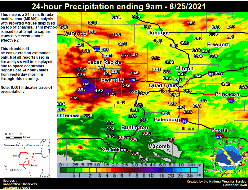
Rainfall Reports
 |
|
24 hour precipitation reports (in Inches), ....IOWA.... |
Environment
SPC EVENT REVIEW PAGE: 08/24/2021
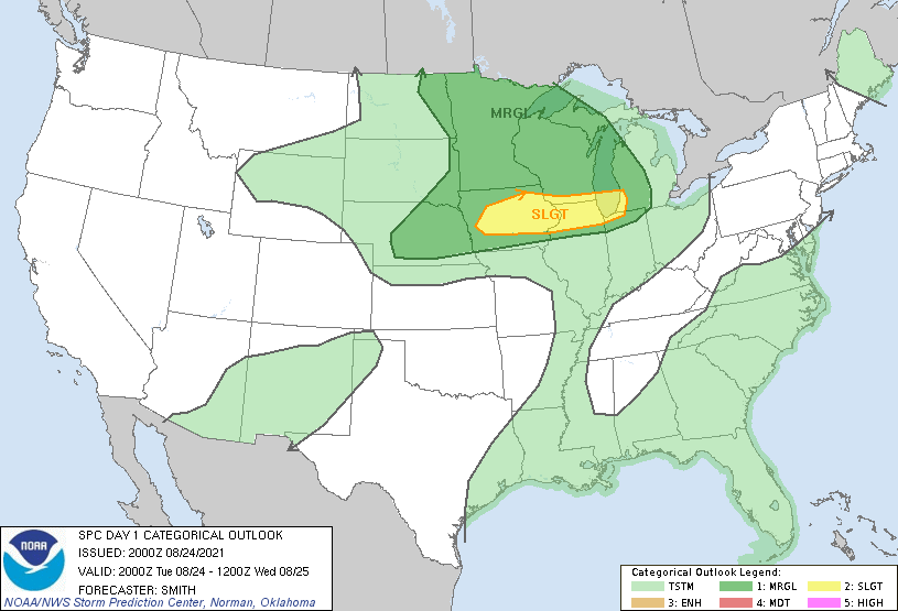
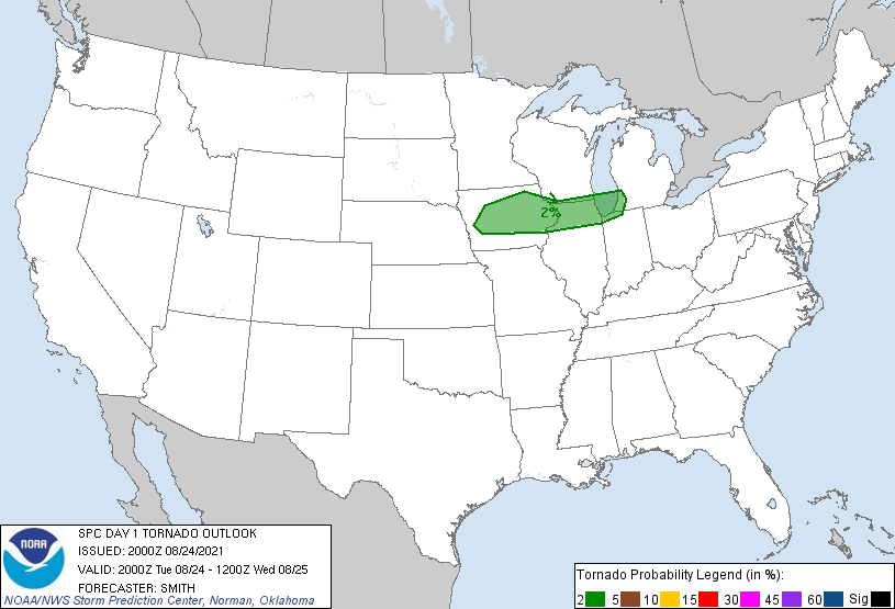
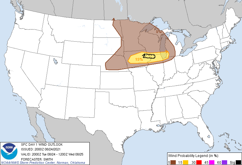
SPC Categorical/Tornado/Hail/Wind Outlooks
 |
 |
 |
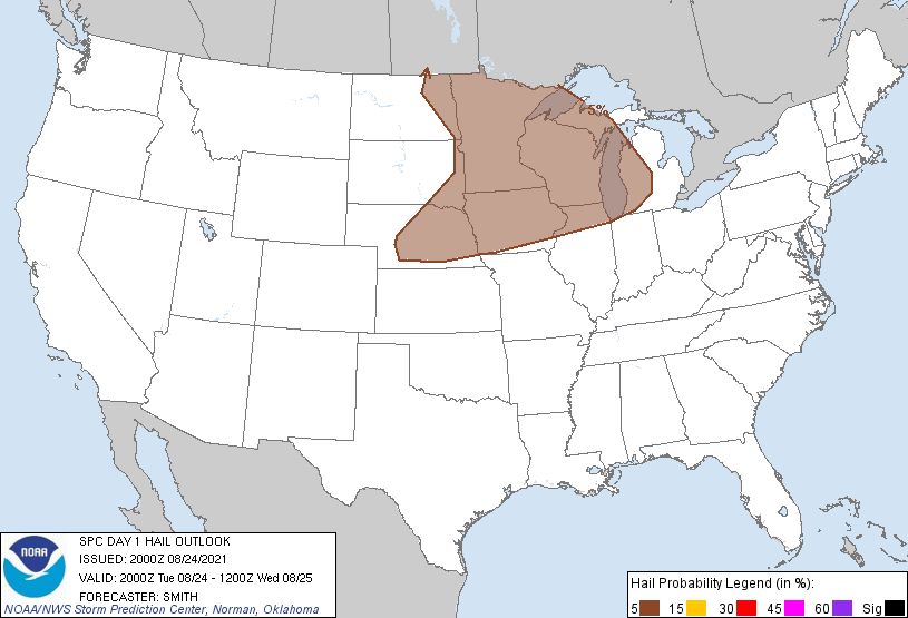 |
| SPC Categorical Outlook | Tornado Outlook | Wind Outlook | Hail Outlook |
DVN Observed Sounding Analysis
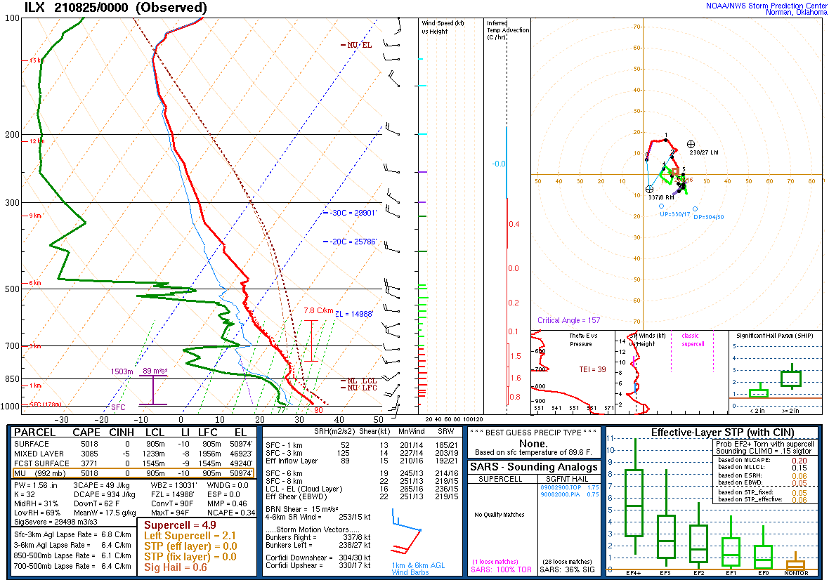 |
| 7 PM Sounding from Lincoln, IL |
| (Note: No 7 PM DVN sounding available due to storms occurring in launch window) |
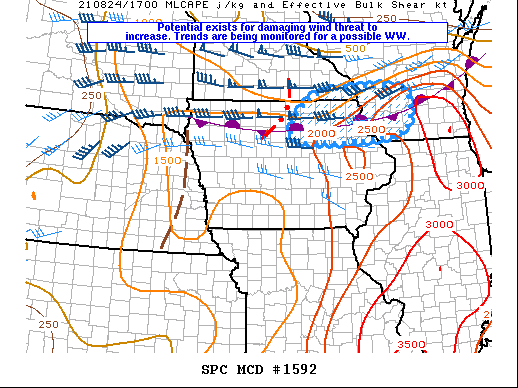
SPC Mesoscale Discussions
 |
 |
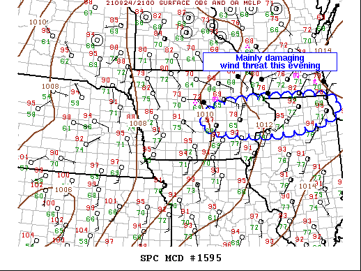 |
| Mesoscale Discussion #1592 | Mesoscale Discussion #1594 | Mesoscale Discussion #1595 |
SPC Convective Watches
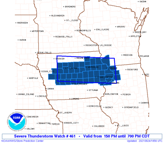 |
| Severe Thunderstorm Watch #461 |
 |
Media use of NWS Web News Stories is encouraged! Please acknowledge the NWS as the source of any news information accessed from this site. |
|