Scattered thunderstorms with severe gusts, hail and a tornado risk are possible near a cold front from the Ohio Valley to the Mid-Atlantic tonight. Tropical Storm Bertha is expected to bring tropical storm conditions to portions of the Gulf Coast from the panhandle of Florida into Louisiana through Wednesday. Read More >
Overview
|
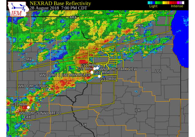
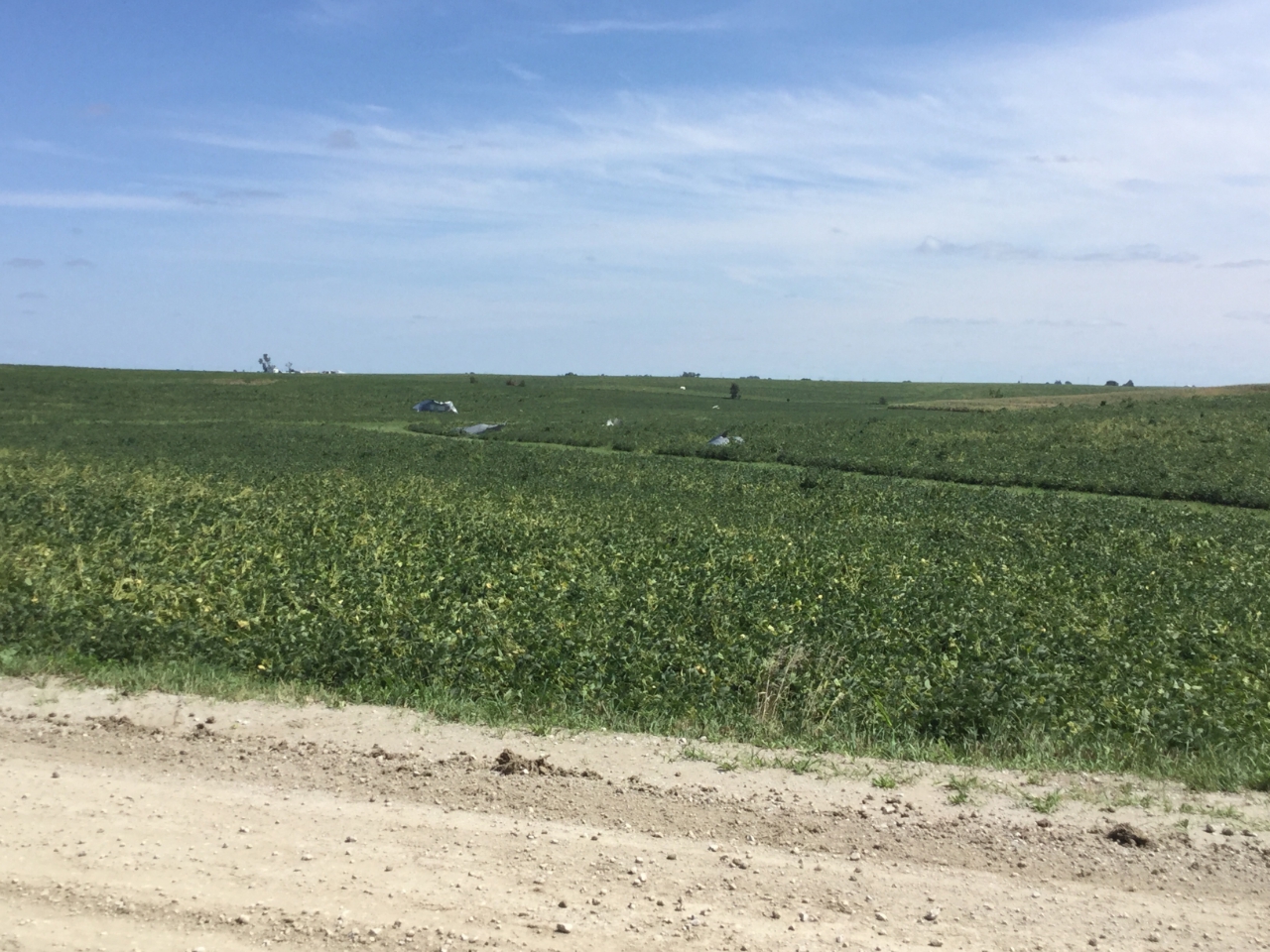
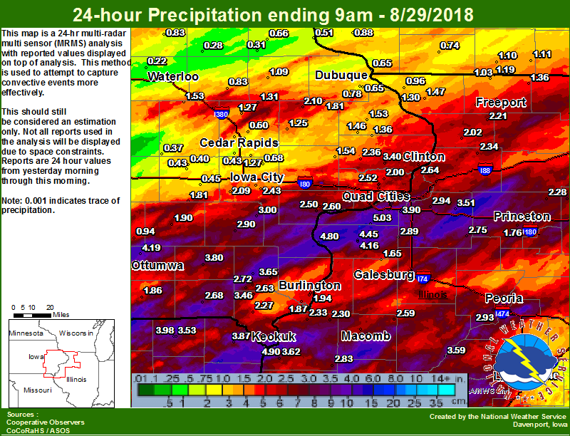
Numerous showers and thunderstorms tracked across eastern Iowa, northwest Illinois, and northeast Missouri during the afternoon and evening of Tuesday, August 28. Very heavy rain, frequent lightning, damaging winds, and a tornado were reported with these storms. A tornado touched down along the Scott/Clinton county border near Donahue, IA or south of Grand Mound, IA causing damage to trees, crops, and a home. Winds between 50 and 90 mph caused several downed power lines, power outages, and tree damage. Rainfall totals between 2 and 4 inches were common along and south of I-80. |
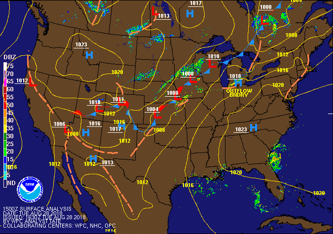 WPC Surface Fronts/Pressure Loop |
Tornadoes/Wind Damage:
|
Tornado - Donahue, IA
Track Map 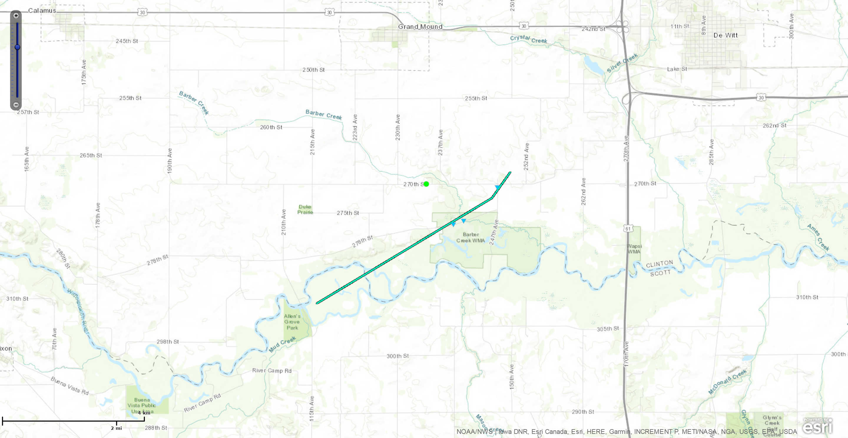 
|
||||||||||||||||
|
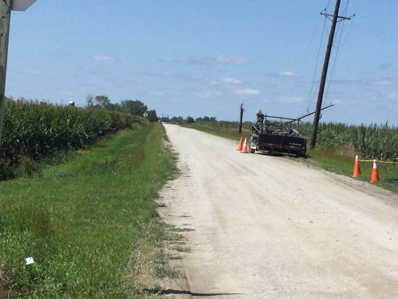
Wind Damage - Mount Pleasant, IA
Track Map 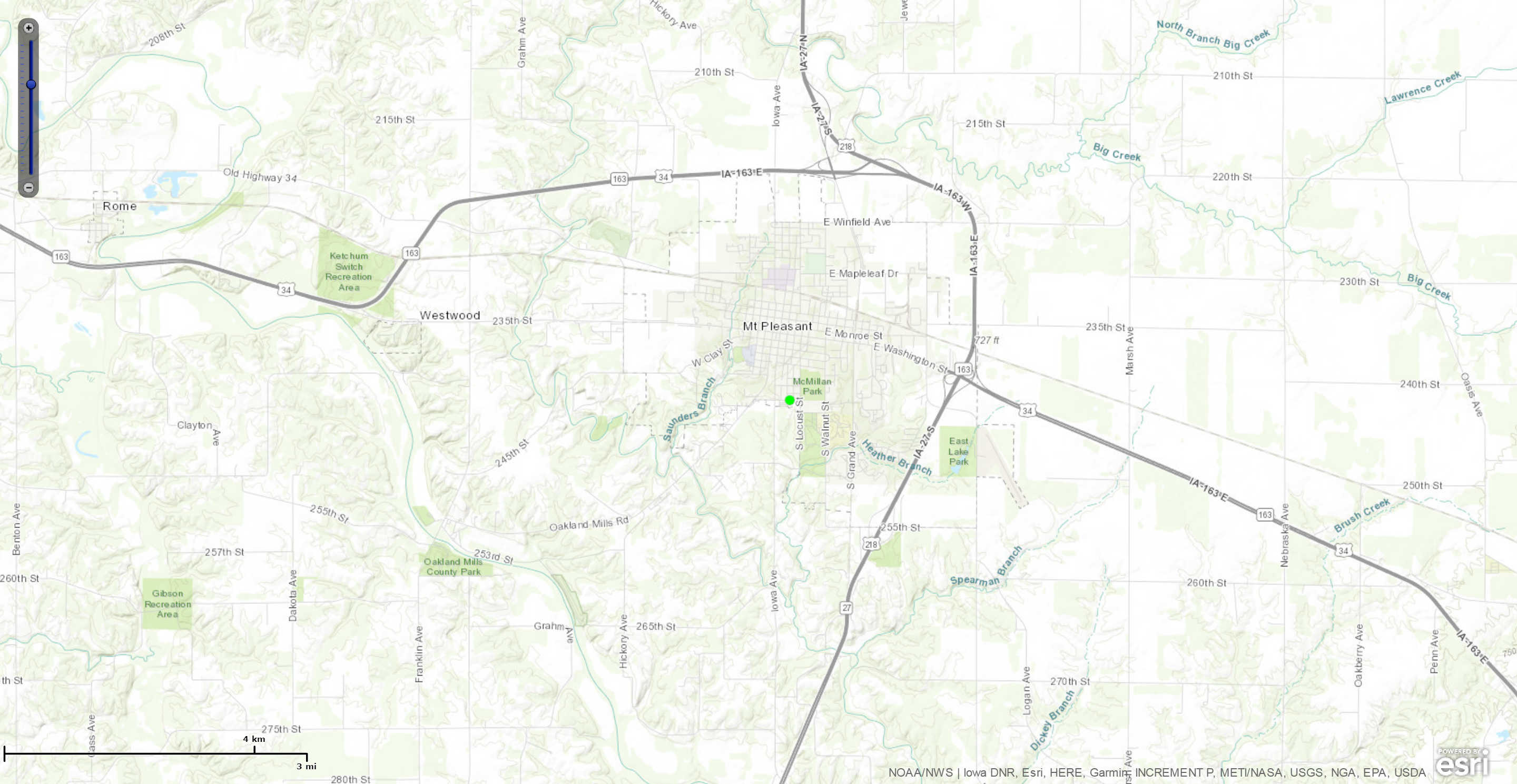
|
||||||||||||||
The Enhanced Fujita (EF) Scale classifies tornadoes into the following categories:
| EF0 Weak 65-85 mph |
EF1 Moderate 86-110 mph |
EF2 Significant 111-135 mph |
EF3 Severe 136-165 mph |
EF4 Extreme 166-200 mph |
EF5 Catastrophic 200+ mph |
 |
|||||
Photos & Video:
 |
 |
 |
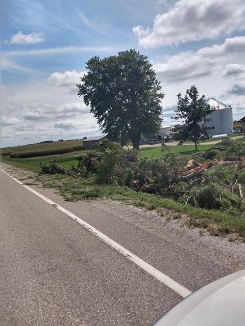 |
| Tree Damage in North English (photo courtesy Megan Fleming) |
Tree Damage in North English (photo courtesy Megan Fleming) |
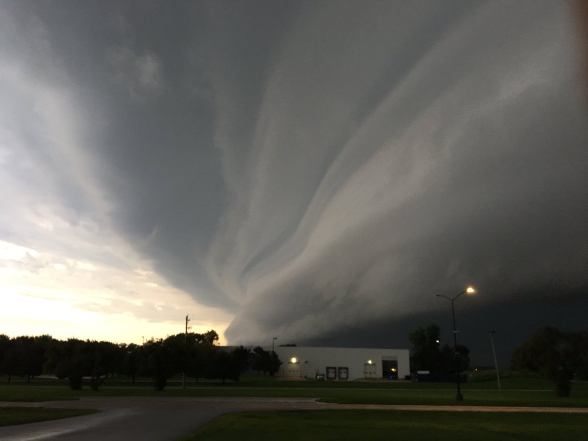
Shelf Cloud from Approaching Thunderstorms @ NWS Quad Cities Office (photo courtesy Ray Wolf) |
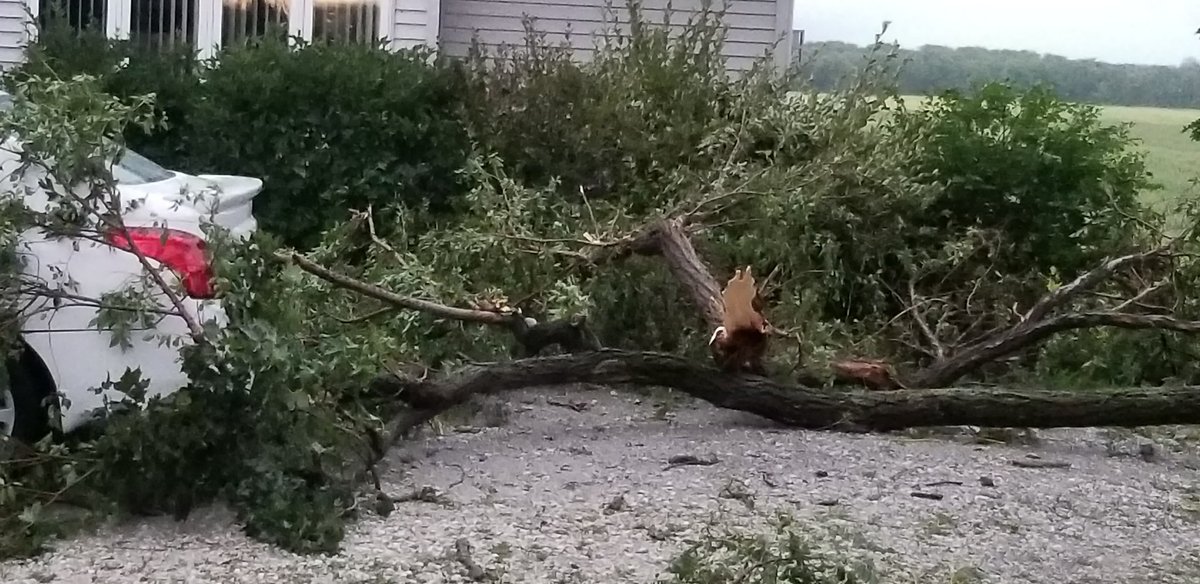
Tree Damage on Muscatine County Road F70 (photo courtesy Travis Stoner) |
 |
 |
 |
 |
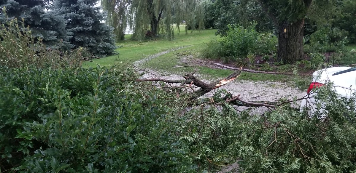
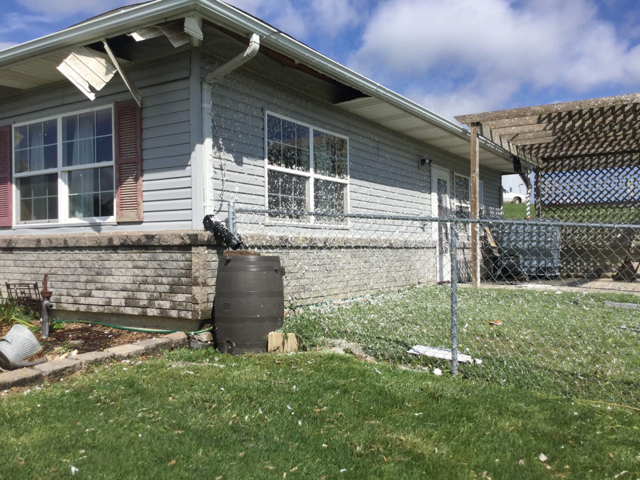
| Wind Damage to home in Iowa County near Parnell, IA (photo courtesy NWS Damage Survey) |
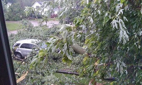
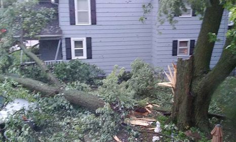
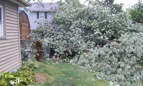
Tree Damage in Mt Pleasant, IA (photo courtesy Vickie Cain) |
Tree Damage in Mt Pleasant, IA (photo courtesy Vickie Cain) |
Tree Damage in Mt Pleasant, IA (photo courtesy Vickie Cain) |
 |
 |
||
| Scattered Farm Outbuilding Pieces near Parnell, IA (photo courtesy NWS Damage Survey) |
Snapped Power Poles near Parnell, IA (photo courtesy NWS Damage Survey) |
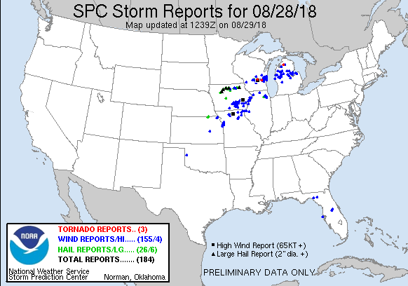
Storm Reports
| Interactive Storm Report Map | SPC Storm Reports |
 |
 |
PRELIMINARY LOCAL STORM REPORT...SUMMARY
NATIONAL WEATHER SERVICE QUAD CITIES IA IL
904 AM CDT WED AUG 29 2018
..TIME... ...EVENT... ...CITY LOCATION... ...LAT.LON...
..DATE... ....MAG.... ..COUNTY LOCATION..ST.. ...SOURCE....
..REMARKS..
0530 PM TSTM WND DMG WHAT CHEER 41.40N 92.35W
08/28/2018 KEOKUK IA PUBLIC
LARGE TREES DOWN IN WHAT CHEER, TIMES
ESTIMATED BASED ON RADAR.
0540 PM TSTM WND DMG SIGOURNEY 41.33N 92.21W
08/28/2018 KEOKUK IA PUBLIC
REPORT OF TREES DOWN IN SIGOURNEY, TIME
ESTIMATED BASED ON RADAR.
0549 PM TSTM WND DMG 2 NNE NORTH ENGLISH 41.55N 92.06W
08/28/2018 IOWA IA BROADCAST MEDIA
POWER LINES DOWN IN HWY 149 & 310TH STREET,
VIA KWWL.
0552 PM TSTM WND GST 1 ENE PARNELL 41.59N 91.99W
08/28/2018 M60 MPH IOWA IA TRAINED SPOTTER
0558 PM TSTM WND DMG PARNELL 41.58N 92.01W
08/28/2018 IOWA IA TRAINED SPOTTER
NUMEROUS TREES DOWN ALL OVER TOWN. NO POWER
AT RESIDENCE.
0605 PM TSTM WND GST COLUMBUS JUNCTION 41.28N 91.37W
08/28/2018 M60 MPH LOUISA IA TRAINED SPOTTER
DELAYED REPORT.
0610 PM TSTM WND DMG WASHINGTON 41.29N 91.69W
08/28/2018 WASHINGTON IA TRAINED SPOTTER
TREES DOWN IN THE CITY OF WASHINGTON.
0615 PM TSTM WND GST 2 W UNIVERSITY HEIGHTS 41.66N 91.60W
08/28/2018 M82 MPH JOHNSON IA EMERGENCY MNGR
WIND GUST MEASURED AT JOHNSON COUNTY EMA.
TIME ESTIMATED BASED ON RADAR.
0615 PM TSTM WND GST WASHINGTON ARPT 41.28N 91.67W
08/28/2018 M52 MPH WASHINGTON IA AWOS
CORRECTS PREVIOUS NON-TSTM WND GST REPORT
FROM WASHINGTON ARPT. AWOS STATION AWG,
WASHINGTON ARPT.
0615 PM TSTM WND GST FAIRFIELD ARPT 41.05N 91.98W
08/28/2018 M46 MPH JEFFERSON IA AWOS
CORRECTS PREVIOUS NON-TSTM WND GST REPORT
FROM FAIRFIELD ARPT. AWOS STATION FFL,
FAIRFIELD ARPT.
0615 PM TSTM WND GST CEDAR RAPIDS ARPT 41.88N 91.71W
08/28/2018 M47 MPH LINN IA ASOS
CORRECTS PREVIOUS NON-TSTM WND GST REPORT
FROM CEDAR RAPIDS ARPT. ASOS STATION CID,
CEDAR RAPIDS ARPT.
0615 PM TSTM WND GST MOUNT UNION 41.06N 91.39W
08/28/2018 M56 MPH HENRY IA TRAINED SPOTTER
0622 PM TSTM WND DMG IOWA CITY 41.66N 91.53W
08/28/2018 JOHNSON IA EMERGENCY MNGR
POWER LINES AND TREE BRANCHES DOWN IN TOWN
AND SOUTH OF TOWN.
0628 PM TSTM WND GST IOWA CITY ARPT 41.64N 91.55W
08/28/2018 M83 MPH JOHNSON IA ASOS
ASOS STATION IOW, IOWA CITY ARPT.
0630 PM TSTM WND GST 2 SE IOWA CITY 41.64N 91.51W
08/28/2018 M70 MPH JOHNSON IA TRAINED SPOTTER
WINDS MEASURED AT 70 MPH BEFORE THE POWER
WENT OUT. THEY WERE LIKELY HIGHER.
0630 PM TSTM WND DMG 2 SE IOWA CITY 41.64N 91.51W
08/28/2018 JOHNSON IA TRAINED SPOTTER
8 TO 12 INCH DIAMETER HARDWOOD TREE UPROOTED
- WINDS WERE MEASURED AT 70 MPH BEFORE THE
POWER FAILED. THEY WERE LIKELY HIGHER.
0635 PM TSTM WND GST MUSCATINE ARPT 41.37N 91.15W
08/28/2018 M58 MPH MUSCATINE IA AWOS
AWOS STATION MUT, MUSCATINE ARPT.
0654 PM TSTM WND DMG 1 ENE MONTPELIER 41.47N 90.78W
08/28/2018 SCOTT IA TRAINED SPOTTER
10 INCH DIAMETER TREE DOWN ON SOUTH
MISSISSIPPI IN BLUEGRASS.
0654 PM TSTM WND GST 1 ENE MONTPELIER 41.47N 90.78W
08/28/2018 M61 MPH SCOTT IA TRAINED SPOTTER
0708 PM TSTM WND GST DAVENPORT MUNICIPALITY 41.62N 90.58W
08/28/2018 M51 MPH SCOTT IA ASOS
0710 PM TSTM WND DMG PARK VIEW 41.69N 90.54W
08/28/2018 SCOTT IA NWS EMPLOYEE
4 INCH BRANCHES DOWN, ESTIMATED WIND GUST OF
60-65MPH.
0710 PM TSTM WND GST SHERRARD 41.32N 90.51W
08/28/2018 M53 MPH MERCER IL ASOS
MEASURED AT I-74 RWIS.
0712 PM TSTM WND DMG 2 E DAVENPORT 41.54N 90.53W
08/28/2018 SCOTT IA NWS EMPLOYEE
NUMEROUS 3 TO 5 INCH DIAMETER BRANCHES DOWN
BETWEEN HWY 74 AND BRIDGE AVE ON LOCUST
STREET. TIME ESTIMATED FROM RADAR.
0713 PM TSTM WND GST 4 SSE MAYSVILLE 41.60N 90.68W
08/28/2018 M59 MPH SCOTT IA ASOS
MEASURED AT THE I80-I280 RWIS.
0725 PM TSTM WND GST 1 NNW BUFFALO 41.47N 90.73W
08/28/2018 E38 MPH SCOTT IA TRAINED SPOTTER
0727 PM TSTM WND DMG BUFFALO 41.47N 90.78W
08/28/2018 SCOTT IA TRAINED SPOTTER
1 MILE EAST OF HACKER ST TREE ON A HOUSE.
0742 PM TSTM WND GST 1 WNW DEWITT 41.83N 90.57W
08/28/2018 E59 MPH CLINTON IA ASOS
MEASURED AT THE DEWITT RWIS.
0747 PM TSTM WND GST CLINTON MUNICIPALITY 41.83N 90.33W
08/28/2018 M61 MPH CLINTON IA AWOS
0750 PM TSTM WND DMG 1 NNW MOUNT CARROLL 42.10N 89.98W
08/28/2018 CARROLL IL TRAINED SPOTTER
NUMEROUS TREE LIMBS AND SMALL TREES DOWN IN
MOUNT CARROLL, ONE TREE ON A HOUSE. TIME
ESTIMATED BASED ON RADAR.
0810 PM TSTM WND GST FREEPORT 42.28N 89.63W
08/28/2018 M48 MPH STEPHENSON IL TRAINED SPOTTER
0830 PM TSTM WND GST 1 NNW KAHOKA 40.43N 91.72W
08/28/2018 M60 MPH CLARK MO TRAINED SPOTTER
MOSTLY WINDS AROUND 40 MPH BUT HAD BRIEF
GUSTS TO 60 MPH.
0830 PM TSTM WND DMG MOUNT PLEASANT 40.96N 91.55W
08/28/2018 HENRY IA EMERGENCY MNGR
REPORT OF POWER LINES DOWN IN THE CITY OF
MOUNT PLEASANT FROM EMERGENCY MANAGEMENT.
0845 PM TSTM WND DMG KEOKUK 40.40N 91.39W
08/28/2018 LEE IA TRAINED SPOTTER
MULTIPLE TREES DOWN IN KEOKUK, ONE AROUND 7
INCHES IN DIAMETER ON ROAD. TREES DOWN ALSO
IN HAMILTON, IL ACROSS THE RIVER. TIME
ESTIMATED FROM RADAR.
0900 PM TSTM WND GST CARTHAGE 40.41N 91.14W
08/28/2018 M60 MPH HANCOCK IL TRAINED SPOTTER
0927 PM TSTM WND DMG ALEDO 41.20N 90.75W
08/28/2018 MERCER IL LAW ENFORCEMENT
TREE DOWN IN ALEDO, REPORTED BY ELECTRIC
COMPANY TO SHERIFF'S OFFICE.
0930 PM TSTM WND DMG 3 E COLMAR 40.35N 90.83W
08/28/2018 MCDONOUGH IL TRAINED SPOTTER
TREE AND POWER LINE DOWN.
0950 PM HEAVY RAIN 2 WSW YARMOUTH 41.02N 91.35W
08/28/2018 M5.10 INCH DES MOINES IA TRAINED SPOTTER
1010 PM HEAVY RAIN 2 SW NEW LONDON 40.91N 91.43W
08/28/2018 M2.07 INCH HENRY IA TRAINED SPOTTER
RAINFALL FROM 7:50-8:40 PM. IT IS STILL
RAINING.
1017 PM HEAVY RAIN MOUNT PLEASANT 40.96N 91.54W
08/28/2018 M3.00 INCH HENRY IA TRAINED SPOTTER
RAINFALL TOTAL FOR THE DAY AS OF 1015 PM.
1140 PM HEAVY RAIN CANTRIL 40.64N 92.07W
08/28/2018 M3.40 INCH VAN BUREN IA TRAINED SPOTTER
STORM TOTAL PAST 12 HOURS.
0500 AM HEAVY RAIN 1 NW GENESEO 41.47N 90.18W
08/29/2018 M2.94 INCH HENRY IL COCORAHS
COCORAHS STATION IL-HY-8, 1 NW GENESEO.
0530 AM HEAVY RAIN 1 NW DAVENPORT 41.56N 90.61W
08/29/2018 M2.36 INCH SCOTT IA TRAINED SPOTTER
STORM TOTAL PAST 24 HOURS.
0600 AM HEAVY RAIN MEMPHIS 40.46N 92.17W
08/29/2018 M3.98 INCH SCOTLAND MO CO-OP OBSERVER
CO-OP OBSERVER STATION MMPM7, MEMPHIS.
0600 AM HEAVY RAIN NEW BOSTON L/D 17 41.18N 91.05W
08/29/2018 M4.80 INCH MERCER IL MESONET
MESONET STATION NBOI2, NEW BOSTON L/D 17.
0600 AM HEAVY RAIN 5 NE BRIGHTON 41.24N 91.77W
08/29/2018 M2.85 INCH WASHINGTON IA COCORAHS
COCORAHS STATION IA-WS-8, 5 NE BRIGHTON.
0600 AM HEAVY RAIN COYNE CENTER 41.40N 90.56W
08/29/2018 M4.50 INCH ROCK ISLAND IL COCORAHS
COCORAHS STATION IL-RI-21, COYNE CENTER.
0600 AM HEAVY RAIN 2 W KEWANEE MUNICIPAL 41.20N 90.00W
08/29/2018 M2.50 INCH HENRY IL COCORAHS
COCORAHS STATION IL-HY-13, 2 W KEWANEE
MUNICIPAL.
0600 AM HEAVY RAIN 2 NE COLUSA 40.60N 91.14W
08/29/2018 M2.33 INCH HANCOCK IL TRAINED SPOTTER
24-HR TOTAL, 50+ MPH WIND ALSO SEEN LAST
NIGHT.
0600 AM HEAVY RAIN 2 S PRAIRIE CITY 40.59N 90.46W
08/29/2018 M2.59 INCH MCDONOUGH IL CO-OP OBSERVER
CO-OP OBSERVER STATION PRCI2, 2 S PRAIRIE
CITY.
0620 AM HEAVY RAIN 3 E SALEM 40.84N 91.56W
08/29/2018 M2.72 INCH HENRY IA COCORAHS
COCORAHS STATION IA-HY-5, 3 E SALEM.
0620 AM HEAVY RAIN 1 ESE NEW LONDON 40.92N 91.40W
08/29/2018 M3.80 INCH HENRY IA TRAINED SPOTTER
STORM TOTAL PAST 24 HOURS.
0629 AM HEAVY RAIN BUSHNELL 40.56N 90.51W
08/29/2018 M2.94 INCH MCDONOUGH IL TRAINED SPOTTER
RAINFALL TOTAL FROM 915 PM - 615 AM THIS
MORNING.
0630 AM HEAVY RAIN RIVERDALE 41.54N 90.45W
08/29/2018 M2.68 INCH SCOTT IA COCORAHS
COCORAHS STATION IA-ST-8, RIVERDALE.
0652 AM HEAVY RAIN DAVENPORT ARPT 41.61N 90.59W
08/29/2018 M2.14 INCH SCOTT IA ASOS
ASOS STATION DVN, DAVENPORT ARPT.
0652 AM HEAVY RAIN IOWA CITY ARPT 41.64N 91.55W
08/29/2018 M2.40 INCH JOHNSON IA ASOS
ASOS STATION IOW, IOWA CITY ARPT.
0655 AM HEAVY RAIN WASHINGTON ARPT 41.28N 91.67W
08/29/2018 M2.39 INCH WASHINGTON IA AWOS
AWOS STATION AWG, WASHINGTON ARPT.
0655 AM HEAVY RAIN MACOMB ARPT 40.52N 90.65W
08/29/2018 M2.24 INCH MCDONOUGH IL AWOS
AWOS STATION MQB, MACOMB ARPT.
0655 AM HEAVY RAIN FAIRFIELD ARPT 41.05N 91.98W
08/29/2018 M3.14 INCH JEFFERSON IA AWOS
AWOS STATION FFL, FAIRFIELD ARPT.
0655 AM HEAVY RAIN KEOKUK ARPT 40.46N 91.43W
08/29/2018 M2.80 INCH LEE IA AWOS
AWOS STATION EOK, KEOKUK ARPT.
0656 AM HEAVY RAIN CLINTON ARPT 41.83N 90.33W
08/29/2018 M2.14 INCH CLINTON IA AWOS
AWOS STATION CWI, CLINTON ARPT.
0659 AM HEAVY RAIN QUAD CITY INTL ARPT 41.45N 90.51W
08/29/2018 M3.64 INCH ROCK ISLAND IL ASOS
ASOS STATION MLI, QUAD CITY INTL ARPT.
0700 AM HEAVY RAIN IOWA CITY 41.65N 91.53W
08/29/2018 M2.43 INCH JOHNSON IA CO-OP OBSERVER
CO-OP OBSERVER STATION ICYI4, IOWA CITY.
0700 AM HEAVY RAIN CAMANCHE 1.2 W 41.80N 90.28W
08/29/2018 M2.64 INCH CLINTON IA COCORAHS
COCORAHS STATION IA-CN-5, CAMANCHE 1.2 W.
0700 AM HEAVY RAIN 2 NNE NEW WINDSOR 41.23N 90.44W
08/29/2018 M2.89 INCH HENRY IL COCORAHS
COCORAHS STATION IL-HY-6, 2 NNE NEW WINDSOR.
0700 AM HEAVY RAIN 2 ENE ARGYLE LAKE STATE 40.46N 90.75W
08/29/2018 M2.46 INCH MCDONOUGH IL COCORAHS
COCORAHS STATION IL-MCD-7, 2 ENE ARGYLE LAKE
STATE.
0700 AM HEAVY RAIN ALEDO 41.22N 90.75W
08/29/2018 M4.16 INCH MERCER IL CO-OP OBSERVER
CO-OP OBSERVER STATION ALEI2, ALEDO.
0700 AM HEAVY RAIN SHANNON 42.15N 89.74W
08/29/2018 M2.21 INCH CARROLL IL COCORAHS
COCORAHS STATION IL-CR-13, SHANNON.
0700 AM HEAVY RAIN 3 NW ELIZA 41.34N 91.01W
08/29/2018 M4.12 INCH ROCK ISLAND IL COCORAHS
COCORAHS STATION IL-RI-22, 3 NW ELIZA.
0700 AM HEAVY RAIN 1 N MUSCATINE 41.44N 91.07W
08/29/2018 M2.50 INCH MUSCATINE IA COCORAHS
COCORAHS STATION IA-MC-10, 1 N MUSCATINE.
0700 AM HEAVY RAIN RIVERDALE 41.54N 90.47W
08/29/2018 M2.79 INCH SCOTT IA COCORAHS
COCORAHS STATION IA-ST-42, RIVERDALE.
0700 AM HEAVY RAIN 1 E KEWANEE 41.25N 89.90W
08/29/2018 M2.75 INCH HENRY IL CO-OP OBSERVER
CO-OP OBSERVER STATION KEWI2, 1 E KEWANEE.
0700 AM HEAVY RAIN PRINCETON 41.38N 89.48W
08/29/2018 M2.52 INCH BUREAU IL CO-OP OBSERVER
CO-OP OBSERVER STATION PTNI2, PRINCETON.
0700 AM HEAVY RAIN PROPHETSTOWN 41.67N 89.94W
08/29/2018 M2.08 INCH WHITESIDE IL COCORAHS
COCORAHS STATION IL-WD-18, PROPHETSTOWN.
0700 AM HEAVY RAIN SALEM 1 S 40.83N 91.62W
08/29/2018 M3.46 INCH HENRY IA CO-OP OBSERVER
CO-OP OBSERVER STATION SLHI4, SALEM 1 S.
0700 AM HEAVY RAIN DONNELLSON 40.63N 91.57W
08/29/2018 M2.27 INCH LEE IA CO-OP OBSERVER
CO-OP OBSERVER STATION DNNI4, DONNELLSON.
0700 AM HEAVY RAIN WASHINGTON 41.28N 91.68W
08/29/2018 M2.90 INCH WASHINGTON IA CO-OP OBSERVER
CO-OP OBSERVER STATION WSHI4, WASHINGTON.
0700 AM HEAVY RAIN 2 S ANDOVER 41.26N 90.29W
08/29/2018 M2.90 INCH HENRY IL COCORAHS
COCORAHS STATION IL-HY-16, 2 S ANDOVER.
0700 AM HEAVY RAIN MOUNT PLEASANT 40.95N 91.55W
08/29/2018 M6.10 INCH HENRY IA CO-OP OBSERVER
CO-OP OBSERVER STATION MPZI4, MOUNT
PLEASANT.
0700 AM HEAVY RAIN NWS DAVENPORT 41.61N 90.58W
08/29/2018 M2.13 INCH SCOTT IA CO-OP OBSERVER
CO-OP OBSERVER STATION DVNI4, NWS DAVENPORT.
0700 AM HEAVY RAIN MACOMB 40.47N 90.67W
08/29/2018 M3.10 INCH MCDONOUGH IL CO-OP OBSERVER
CO-OP OBSERVER STATION MQBI2, MACOMB.
0700 AM HEAVY RAIN LA HARPE 40.58N 90.97W
08/29/2018 M2.30 INCH HANCOCK IL CO-OP OBSERVER
CO-OP OBSERVER STATION LAHI2, LA HARPE.
0700 AM HEAVY RAIN SUTTER 40.29N 91.36W
08/29/2018 M3.62 INCH HANCOCK IL COCORAHS
COCORAHS STATION IL-HN-2, SUTTER.
0700 AM HEAVY RAIN 2 ENE CALAMUS 41.84N 90.73W
08/29/2018 M2.36 INCH CLINTON IA COCORAHS
COCORAHS STATION IA-CN-2, 2 ENE CALAMUS.
0700 AM HEAVY RAIN PARK VIEW 41.69N 90.54W
08/29/2018 M2.00 INCH SCOTT IA COCORAHS
COCORAHS STATION IA-ST-3, PARK VIEW.
0700 AM HEAVY RAIN 2 WSW CHADWICK 42.00N 89.94W
08/29/2018 M2.02 INCH CARROLL IL COCORAHS
COCORAHS STATION IL-CR-4, 2 WSW CHADWICK.
0700 AM HEAVY RAIN ELDRIDGE 41.65N 90.59W
08/29/2018 M2.45 INCH SCOTT IA COCORAHS
COCORAHS STATION IA-ST-21, ELDRIDGE.
0700 AM HEAVY RAIN 4 N HASKINS 41.40N 91.54W
08/29/2018 M3.00 INCH WASHINGTON IA COCORAHS
COCORAHS STATION IA-WS-2, 4 N HASKINS.
0700 AM HEAVY RAIN AUGUSTA 40.23N 90.93W
08/29/2018 M2.83 INCH HANCOCK IL CO-OP OBSERVER
CO-OP OBSERVER STATION AUGI2, AUGUSTA.
0700 AM HEAVY RAIN WOODHULL 41.18N 90.32W
08/29/2018 M3.23 INCH HENRY IL COCORAHS
COCORAHS STATION IL-HY-11, WOODHULL.
0700 AM HEAVY RAIN 1 SW COLETA 41.89N 89.81W
08/29/2018 M2.34 INCH WHITESIDE IL COCORAHS
COCORAHS STATION IL-WD-8, 1 SW COLETA.
0700 AM HEAVY RAIN 2 N MUSCATINE 41.47N 91.04W
08/29/2018 M2.50 INCH MUSCATINE IA CO-OP OBSERVER
CO-OP OBSERVER STATION MSTI4, 2 N MUSCATINE.
0700 AM HEAVY RAIN MONTICELLO 42.25N 91.17W
08/29/2018 M2.10 INCH JONES IA CO-OP OBSERVER
CO-OP OBSERVER STATION MCLI4, MONTICELLO.
0700 AM HEAVY RAIN 1 SSE OPHIEM 41.23N 90.37W
08/29/2018 M2.43 INCH HENRY IL COCORAHS
COCORAHS STATION IL-HY-12, 1 SSE OPHIEM.
0700 AM HEAVY RAIN MOLINE 41.50N 90.49W
08/29/2018 M4.07 INCH ROCK ISLAND IL COCORAHS
COCORAHS STATION IL-RI-3, MOLINE.
0700 AM HEAVY RAIN 1 E REYNOLDS 41.34N 90.65W
08/29/2018 M5.03 INCH ROCK ISLAND IL COCORAHS
COCORAHS STATION IL-RI-17, 1 E REYNOLDS.
0700 AM HEAVY RAIN 4 S ANDOVER 41.24N 90.30W
08/29/2018 M2.60 INCH HENRY IL COCORAHS
COCORAHS STATION IL-HY-17, 4 S ANDOVER.
0700 AM HEAVY RAIN 1 WNW PILOT GROVE 40.78N 91.56W
08/29/2018 M2.63 INCH LEE IA COCORAHS
COCORAHS STATION IA-LE-11, 1 WNW PILOT
GROVE.
0700 AM HEAVY RAIN MEDIAPOLIS 41.01N 91.16W
08/29/2018 M3.50 INCH DES MOINES IA PUBLIC
24-HR TOTAL.
0700 AM HEAVY RAIN MILLEDGEVILLE 41.97N 89.78W
08/29/2018 M2.31 INCH CARROLL IL COCORAHS
COCORAHS STATION IL-CR-14, MILLEDGEVILLE.
0700 AM HEAVY RAIN KAHOKA 0.6 S 40.41N 91.72W
08/29/2018 M3.87 INCH CLARK MO COCORAHS
COCORAHS STATION MO-FSA-045, KAHOKA 0.6 S.
0700 AM HEAVY RAIN MEMPHIS 40.46N 92.17W
08/29/2018 M3.53 INCH SCOTLAND MO COCORAHS
COCORAHS STATION MO-FSA-199, MEMPHIS.
0700 AM HEAVY RAIN 2 N MUSCATINE 41.45N 91.07W
08/29/2018 M2.62 INCH MUSCATINE IA COCORAHS
COCORAHS STATION IA-MC-13, 2 N MUSCATINE.
0700 AM HEAVY RAIN 1 WSW NEW LONDON 40.91N 91.43W
08/29/2018 M3.65 INCH HENRY IA COCORAHS
COCORAHS STATION IA-HY-1, 1 WSW NEW LONDON.
0700 AM HEAVY RAIN 1 SE PRINCETON 41.37N 89.45W
08/29/2018 M2.52 INCH BUREAU IL COCORAHS
COCORAHS STATION IL-BU-5, 1 SE PRINCETON.
0708 AM HEAVY RAIN 3 SSE SCIOTA 40.52N 90.72W
08/29/2018 M2.30 INCH MCDONOUGH IL COCORAHS
COCORAHS STATION IL-MCD-6, 3 SSE SCIOTA.
0720 AM HEAVY RAIN 5 W MAGNOLIA 41.11N 89.28W
08/29/2018 M2.50 INCH PUTNAM IL TRAINED SPOTTER
EVENT TOTAL THROUGH 7AM.
0730 AM HEAVY RAIN POPE CRK NEAR KEITHSBUR 41.13N 90.92W
08/29/2018 M3.37 INCH MERCER IL MESONET
MESONET STATION PCKI2, POPE CRK NEAR
KEITHSBURG.
0730 AM HEAVY RAIN HENDERSON CRK AT OQUAWK 40.92N 91.00W
08/29/2018 M2.67 INCH DES MOINES IA MESONET
MESONET STATION OQUI2, HENDERSON CRK AT
OQUAWKA.
0730 AM HEAVY RAIN EDWARDS RVR AT NEW BOST 41.19N 90.97W
08/29/2018 M3.34 INCH MERCER IL MESONET
MESONET STATION NWBI2, EDWARDS RVR AT NEW
BOSTON.
0730 AM HEAVY RAIN FOX RVR AT WAYLAND 40.39N 91.60W
08/29/2018 M4.35 INCH CLARK MO MESONET
MESONET STATION WYLM7, FOX RVR AT WAYLAND.
0740 AM HEAVY RAIN 1 SE DAVENPORT 41.54N 90.59W
08/29/2018 M2.21 INCH SCOTT IA TRAINED SPOTTER
24-HR TOTAL.
0745 AM HEAVY RAIN LA MOINE RVR AT COLMAR 40.33N 90.90W
08/29/2018 M2.78 INCH MCDONOUGH IL MESONET
MESONET STATION CLMI2, LA MOINE RVR AT
COLMAR.
0750 AM HEAVY RAIN 3 WNW MOUNT STERLING 40.64N 91.98W
08/29/2018 M2.90 INCH VAN BUREN IA TRAINED SPOTTER
24-HR TOTAL.
0800 AM HEAVY RAIN DE WITT 41.82N 90.57W
08/29/2018 M3.40 INCH CLINTON IA CO-OP OBSERVER
CO-OP OBSERVER STATION DWTI4, DE WITT.
0800 AM HEAVY RAIN ILLINOIS CITY L/D 16 41.42N 91.02W
08/29/2018 M2.62 INCH ROCK ISLAND IL MESONET
MESONET STATION ILNI2, ILLINOIS CITY L/D 16.
0800 AM HEAVY RAIN 2 NE ATKINSON 41.45N 89.99W
08/29/2018 M3.51 INCH HENRY IL COCORAHS
COCORAHS STATION IL-HY-4, 2 NE ATKINSON.
0800 AM HEAVY RAIN 4 SSE SHANNON 42.10N 89.72W
08/29/2018 M2.35 INCH CARROLL IL COCORAHS
COCORAHS STATION IL-CR-18, 4 SSE SHANNON.
0800 AM HEAVY RAIN FULTON L/D 13 41.92N 90.15W
08/29/2018 M2.09 INCH WHITESIDE IL MESONET
MESONET STATION FLTI2, FULTON L/D 13.
0800 AM HEAVY RAIN FAIRFIELD 41.03N 91.95W
08/29/2018 M3.80 INCH JEFFERSON IA CO-OP OBSERVER
CO-OP OBSERVER STATION FRFI4, FAIRFIELD.
0800 AM HEAVY RAIN IOWA RVR AT WAPELLO 41.18N 91.18W
08/29/2018 M2.89 INCH LOUISA IA MESONET
MESONET STATION WAPI4, IOWA RVR AT WAPELLO.
0800 AM HEAVY RAIN LA MOILLE 41.53N 89.28W
08/29/2018 M2.28 INCH BUREAU IL COCORAHS
COCORAHS STATION IL-BU-9, LA MOILLE.
0800 AM HEAVY RAIN ROCK ISLAND L/D 15 41.52N 90.57W
08/29/2018 M2.66 INCH ROCK ISLAND IL MESONET
MESONET STATION RCKI2, ROCK ISLAND L/D 15.
0800 AM HEAVY RAIN ALEDO 41.21N 90.75W
08/29/2018 M4.45 INCH MERCER IL COCORAHS
COCORAHS STATION IL-MR-7, ALEDO.
0800 AM HEAVY RAIN 2 WNW NEKOMA 41.19N 90.23W
08/29/2018 M3.21 INCH HENRY IL COCORAHS
COCORAHS STATION IL-HY-20, 2 WNW NEKOMA.
0800 AM HEAVY RAIN IOWA RVR AT IOWA CITY 41.66N 91.54W
08/29/2018 M2.14 INCH JOHNSON IA MESONET
MESONET STATION IOWI4, IOWA RVR AT IOWA
CITY.
0800 AM HEAVY RAIN LE CLAIRE L/D 14 41.58N 90.42W
08/29/2018 M2.15 INCH SCOTT IA MESONET
MESONET STATION LECI4, LE CLAIRE L/D 14.
0800 AM HEAVY RAIN IOWA RVR AT COLUMBUS JC 41.28N 91.35W
08/29/2018 M3.25 INCH LOUISA IA MESONET
MESONET STATION CJTI4, IOWA RVR AT COLUMBUS
JCT.
0807 AM HEAVY RAIN FARMINGTON 40.65N 91.72W
08/29/2018 M2.35 INCH VAN BUREN IA MESONET
MESONET STATION FRMI4, FARMINGTON.
0807 AM HEAVY RAIN 3 ENE BENTLEY 40.36N 91.06W
08/29/2018 M2.41 INCH HANCOCK IL MESONET
MESONET STATION AT304, 3 ENE BENTLEY.
0810 AM HEAVY RAIN KEOKUK L/D 19 40.40N 91.37W
08/29/2018 M4.11 INCH HANCOCK IL MESONET
MESONET STATION EOKI4, KEOKUK L/D 19.
0815 AM HEAVY RAIN MS RVR AT MUSCATINE 41.38N 91.05W
08/29/2018 M2.16 INCH ROCK ISLAND IL MESONET
MESONET STATION MUSI4, MS RVR AT MUSCATINE.
0815 AM HEAVY RAIN KEOSAUQUA 40.73N 91.97W
08/29/2018 M3.38 INCH VAN BUREN IA CO-OP OBSERVER
CO-OP OBSERVER STATION KEQI4, KEOSAUQUA.
0828 AM HEAVY RAIN ALEDO 41.21N 90.76W
08/29/2018 M3.49 INCH MERCER IL MESONET
MESONET STATION C2758, ALEDO.
0829 AM HEAVY RAIN CENTRAL CITY 42.21N 91.52W
08/29/2018 M3.20 INCH LINN IA MESONET
MESONET STATION CNTRA, CENTRAL CITY.
0829 AM HEAVY RAIN MORRISON 41.80N 89.96W
08/29/2018 M4.32 INCH WHITESIDE IL MESONET
MESONET STATION MRSON, MORRISON.
0830 AM HEAVY RAIN MS RVR AT KEITHSBURG 41.10N 90.95W
08/29/2018 M2.28 INCH LOUISA IA MESONET
MESONET STATION KHBI2, MS RVR AT KEITHSBURG.
0830 AM HEAVY RAIN MS RVR AT FAIRPORT 41.43N 90.88W
08/29/2018 M2.77 INCH ROCK ISLAND IL MESONET
MESONET STATION FAII4, MS RVR AT FAIRPORT.
0830 AM HEAVY RAIN 1 NNW PRINCETON 41.40N 89.47W
08/29/2018 M2.31 INCH BUREAU IL MESONET
MESONET STATION F2873, 1 NNW PRINCETON.
0830 AM HEAVY RAIN 1 W BETTENDORF 41.56N 90.49W
08/29/2018 M2.53 INCH SCOTT IA TRAINED SPOTTER
24 HOUR TOTAL.
0830 AM HEAVY RAIN CEDAR CRK NEAR OAKLAND 40.93N 91.67W
08/29/2018 M3.91 INCH HENRY IA MESONET
MESONET STATION OKMI4, CEDAR CRK NEAR
OAKLAND MILLS.
0833 AM HEAVY RAIN 1 ENE OAK GROVE 41.42N 90.55W
08/29/2018 M4.11 INCH ROCK ISLAND IL MESONET
MESONET STATION D2227, 1 ENE OAK GROVE.
0836 AM HEAVY RAIN 3 ENE CHARLIE HEATH MEM 40.59N 91.84W
08/29/2018 E2.60 INCH CLARK MO TRAINED SPOTTER
24 HOUR TOTAL. ANOTHER 0.6 INCHES OVERNIGHT.
0843 AM HEAVY RAIN GALVA 41.16N 90.04W
08/29/2018 M2.45 INCH HENRY IL TRAINED SPOTTER
24 HR TOTAL.
|
|
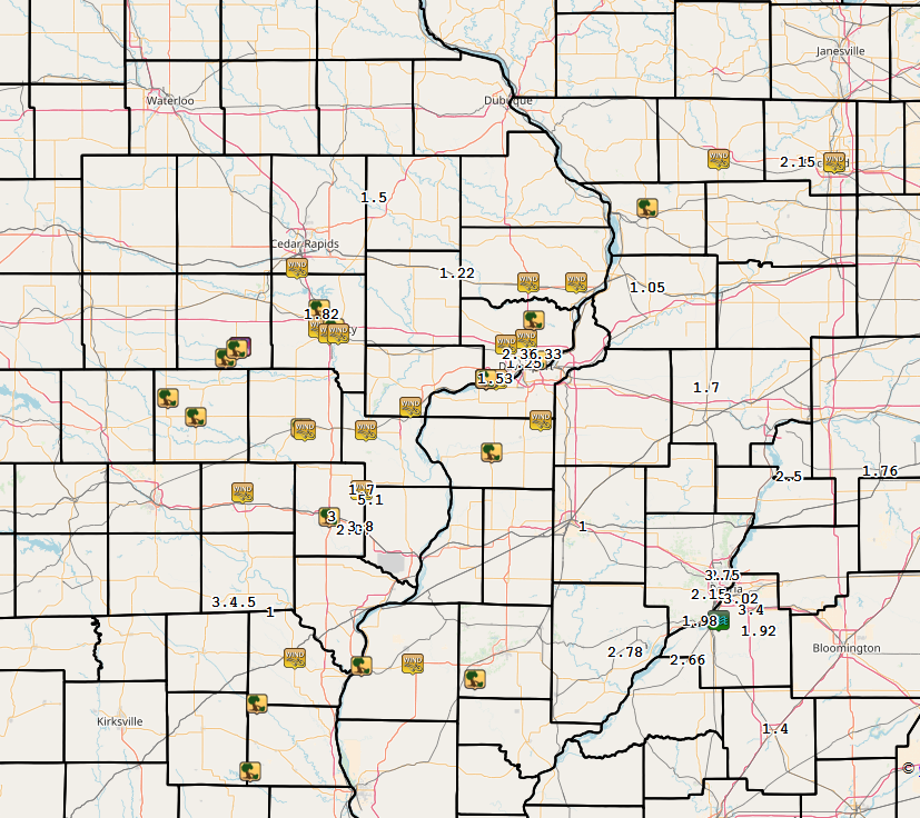
Rain Reports
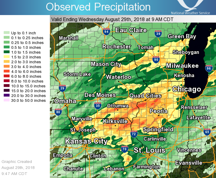
| Local Rainfall Map | Regional Estimated Rainfall |
 |
 |
24 hour precipitation reports (in Inches), for eastern Iowa, northwest and west central Illinois, and northeast Missouri. Reported between Midnight and 9 AM, Wednesday August 29, 2018. ....IOWA.... Mt Pleasant 1 SSW 6.10 Keokuk LD19 4.90 Ottumwa ASOS 6 NNW 4.19 Fairfield 3.80 New London 1.5 SW 3.65 Salem 1S 3.46 De Witt 3.40 Ainsworth 7.4 N 3.00 Davenport 0.9 SSW 2.95 Washington 2.90 Salem 3.1 ESE 2.72 Keosauqua 2.68 Bettendorf 2.2 SE 2.68 Camanche 1.2 W 2.64 West Point 7.5 NW 2.63 Brighton 2.61 Bettendorf 1.6 WSW 2.58 Eldridge 0.7 SSW 2.52 Muscatine 2N 2.50 Muscatine 1.4 N 2.50 Le Claire LD14 2.46 Eldridge 0.6 S 2.45 Iowa City 2.43 Iowa City Arpt 2.40 Calamus 2.0 NE 2.36 Donnellson 2.27 Davenport 0.9 WNW 2.21 Albia 3 NNE 2.20 Davenport Arpt 5 N 2.14 Monticello 1 E 2.10 Kalona 7.3 NNW 2.09 Park View 0.2 WSW 2.00 Burlington 0.8 SSE 1.94 Sigourney 1.90 Davenport 3.8 NNW 1.89 Burlington Arpt 2 SW 1.89 Burlington 6.5 SSW 1.87 Bloomfield 1 NW 1.86 North English 1.81 Cascade 1.81 Marshalltown 1 NW 1.68 Center Point 0.6 NNW 1.66 Lowden 1.54 Mount Auburn 2.2 NNW 1.53 Fulton 1.53 Maquoketa 4W 1.46 Centerville 0 NE 1.40 Marshalltown ASOS 4 N 1.39 Perry 0 W 1.37 Delmar 2.3 NW 1.36 Mason City 1 NNE 1.31 Coggon 1.31 Bellevue LD12 1.30 Central City 6.7 W 1.27 Ely 0.5 SE 1.27 Anamosa 3 SSW 1.25 Cresco 1 NE 1.23 Manchester 1.09 Hampton 1 N 1.07 Mason City ASOS 6 W 1.00 Rathbun Reservoir 2 N 0.96 Pella 4 N 0.95 Oskaloosa AWOS 9 ESE 0.94 Boone 1 SSW 0.91 Beaconsfield 1 NNE 0.85 Quasqueton 0.5 W 0.83 Tripoli 0 N 0.83 Ames US 30 2 SSE 0.82 Dubuque #3 7 SW 0.78 Solon 0.3 ESE 0.68 Elkader 6SSW 0.66 Dubuque LD11 0.65 Dubuque Arpt 7 SW 0.65 Marion 1.7 NNW 0.60 Guttenberg Dam 10 0.51 Cedar Rapids 2.7 NE 0.49 Cedar Rapids 3.4 NW 0.48 Williamsburg 0.45 Cedar Rapids Arpt 5 SW 0.43 Marengo 2.6 SSW 0.43 Marengo 0.40 Belle Plaine 0.37 Toledo 3 N 0.31 Strawberry Point 0.31 Grinnell 2 SW 0.28 Oelwein AWOS 0.28 Grinnell AWOS 2 SSW 0.24 Waterloo ASOS 5 NW 0.22 Newton 1 NE 0.21 NWS Johnston* 5 NNW 0.09 Mason City* 0 E 0.00 Pella AWOS 2 WSW 0.00 ....ILLINOIS.... Milan 8.8 SSW 5.03 New Boston LD17 4.80 Aledo 0.7 NNW 4.45 Aledo 4.16 Moline 0.9 N 4.07 Coal Valley 1.9 SE 3.90 Quad City Arpt 3 S 3.64 Warsaw 5.8 SE 3.62 Havana 3.59 Atkinson 2.6 NNE 3.51 Macomb 3.10 Geneseo 2.0 NW 2.94 Peoria ASOS 2.93 New Windsor 2.0 N 2.89 Augusta 2.83 Kewanee 1 E 2.75 Ill. City LD16 3 WNW 2.60 Prairie City 2S 2.59 Princeton 1.1 SE 2.52 Princeton 2.52 Colchester 3.5 NE 2.46 Coleta 1.4 SSW 2.34 Dallas City 3.0 SSE 2.33 La Harpe 2.30 Macomb 3.8 NW 2.30 La Moille 0.2 NNE 2.28 Shannon 0.2 S 2.21 Galesburg 2.20 Mendota 2 SE 2.11 Chadwick 2.7 WSW 2.02 Roscoe 2SE 1.99 Steward 1.95 Quincy ASOS 1.95 Galesburg Arpt 3 SW 1.93 Paw Paw 1 E 1.86 Monmouth 4NW 1.81 Rochelle 1.79 Pearl City 0.4 SW 1.78 Tiskilwa 2.1 N 1.76 Rockford ASOS 1.68 Freeport 1.65 Alexis 1 SW 1.65 Mundelein 1.57 Freeport 2.0 NW 1.54 Bloomington Airport 1.54 Ottawa 4 SW 1.50 Elizabeth 1.47 Lincoln NWS 1.40 Davis 0.5 N 1.36 Jacksonville AWOS 1.35 Streator 3 SE 1.27 Romeoville 1.19 Orangeville 2.8 NW 1.19 Winslow 4.3 ESE 1.03 Galena 0.96 Joliet 0.80 St Anne 0.46 Decatur Airport 0.27 Tuscola 0.20 Ogden 0.16 Windsor 0.00 Rochelle AWOS 0.00 ....MISSOURI.... Memphis 3.98 Kahoka 0.6 S 3.87 Kirksville ASOS 3.81 Memphis 0.1 S 3.53 Chillicothe 2 NW 2.17 Columbia 1.12 ....WISCONSIN.... La Crosse WFO 1.55 Allenton-WWTP .6 NW 1.51 Beloit-College 1.26 Delavan-1 W-WWTP 1 W 1.21 Brodhead 1 SW 1.11 Monroe 1 W 1.10 Lancaster 4WSW 0.88 Prairie du Chien AWOS 0.84 Madison-ASOS 0.82 Whitewater 0.82 Darlington 0.74 Watertown-AWOS 0.00 ....MINNESOTA.... Preston 1.60 Grand Meadow 0.50 |
|
Environment
 |
 |
 |
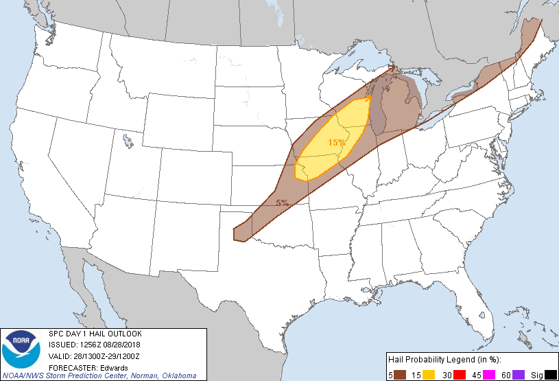 |
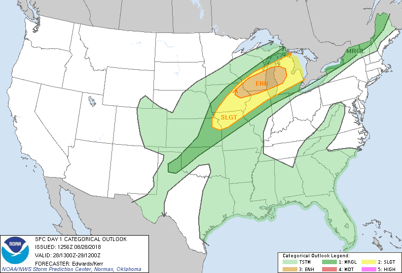
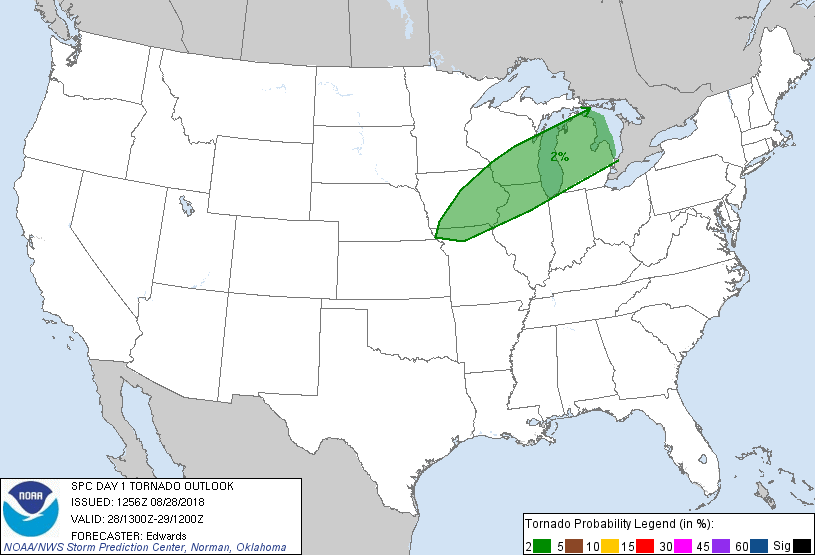
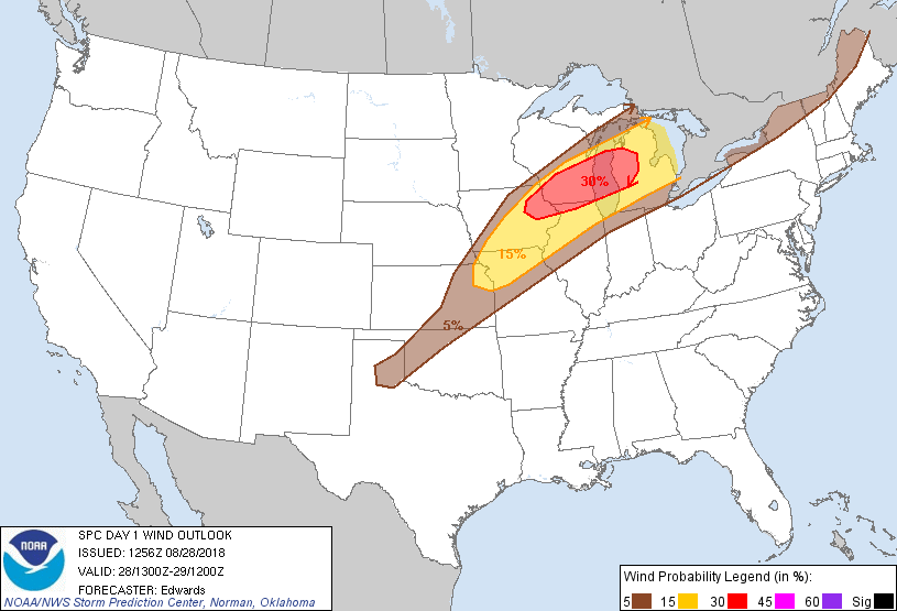
| Figure 1: SPC Day 1 Outlook (1300z) | Figure 2: SPC Day 1 Tornado Outlook (1300z) | Figure 3: SPC Day 1 Wind Outlook (1300z) | Figure 4: SPC Day 1 Hail Outlook (1300z) |
 |
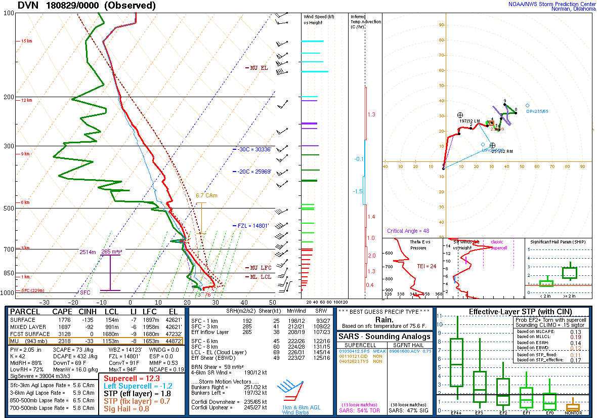 |
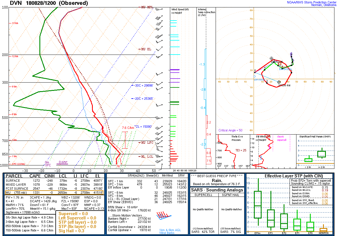
| Figure 5: DVN Sounding 8/28/18 12z | Figure 6: DVN Sounding 8/29/18 00z |
Additional environmental data.
 |
 |
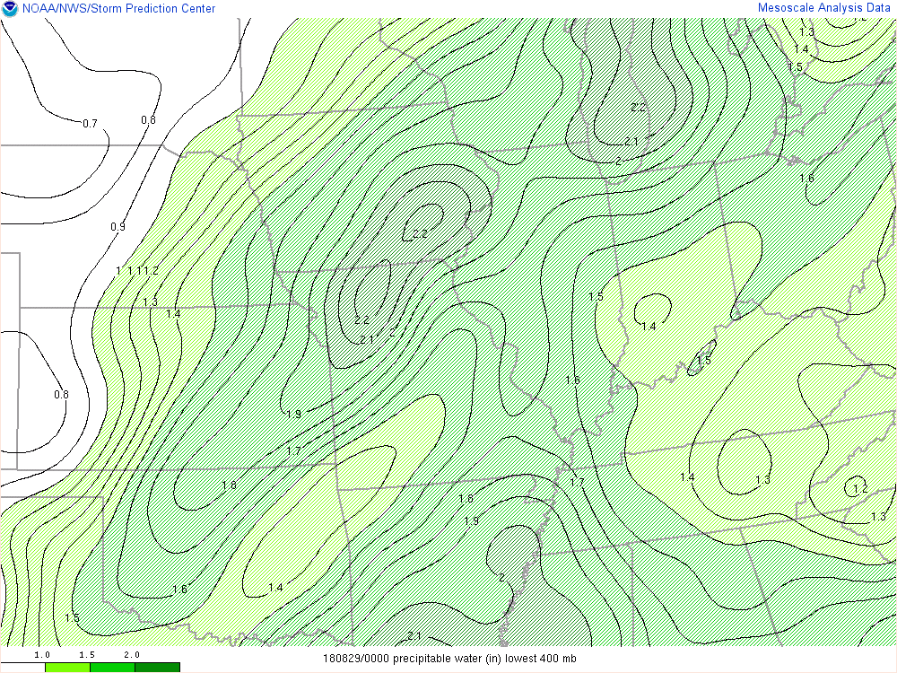 |
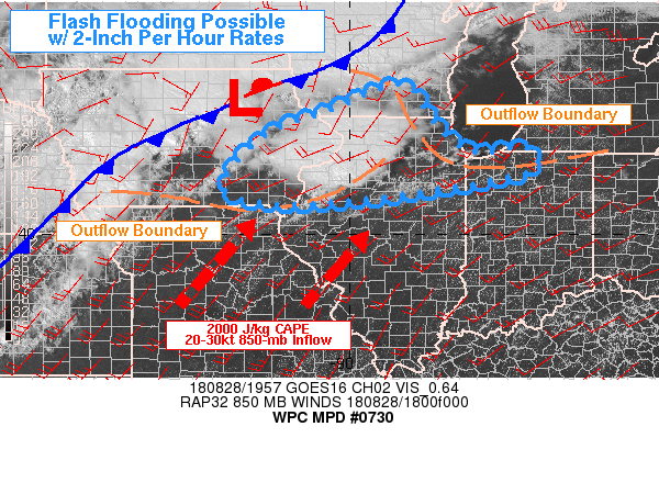
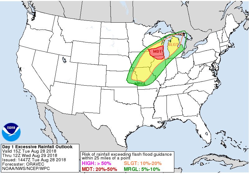
| Figure 7: WPC Mesoscale Precipitation Discussion (see link for details) | Figure 8: WPC Excessive Rainfall Outlook | Figure 9: 8/29/18 SPC Mesoanalysis Precipitable Water 00z |
 |
Media use of NWS Web News Stories is encouraged! Please acknowledge the NWS as the source of any news information accessed from this site. |
|