Overview
|
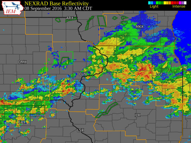
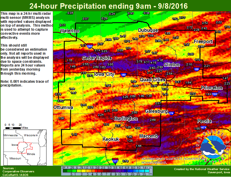
Showers and thunderstorms swept eastward across the area during the afternoon of September 7th, with torrential rains and gusty winds of 30 to 45 mph common in most locations with the stronger storms. An isolated severe storm near the Macomb, IL golf course snapped a sign post and downed a large tree limb just after 4 pm. After a lull in the thunderstorm activity through the late afternoon and early evening, another severe storm moved across Des Moines and Henderson counties with damaging winds and flash flooding. The Burlington Airport recorded 2.69 inches of rain, with 1.90 inches falling between 8 and 9 pm. Flash flooding was observed throughout the city, with road closures and at least one car with four people stuck in flood waters. In addition, some funnel cloud sightings were also reported with this storm. Later that night, several thunderstorms tracked eastward along and just north of the Highway 30 corridor depositing 3 to nearly 5 inches of rain! Flash flooding was observed in Cedar Rapids, with cars abandoned in flood waters.
|
|
Storm Reports
| Interactive Report Map |
 |
Non-"Heavy Rain" reports are listed at the bottom. PRELIMINARY LOCAL STORM REPORT...SUMMARY NATIONAL WEATHER SERVICE QUAD CITIES IA IL 853 AM CDT THU SEP 8 2016 ..TIME... ...EVENT... ...CITY LOCATION... ...LAT.LON... ..DATE... ....MAG.... ..COUNTY LOCATION..ST.. ...SOURCE.... ..REMARKS.. 0656 AM HEAVY RAIN 3 NNE CEDAR RAPIDS 42.01N 91.65W 09/08/2016 M4.68 INCH LINN IA TRAINED SPOTTER 24-HR TOTAL. 0800 AM HEAVY RAIN 1 WSW DEWITT 41.82N 90.57W 09/08/2016 M4.54 INCH CLINTON IA CO-OP OBSERVER CO-OP OBSERVER STATION DE WITT /DWTI4/. 0700 AM HEAVY RAIN 2 NE CALAMUS 41.84N 90.73W 09/08/2016 M4.17 INCH CLINTON IA COCORAHS COCORAHS STATION 2 ENE CALAMUS /IA-CN-2/. 0700 AM HEAVY RAIN 1 N DEWITT 41.83N 90.54W 09/08/2016 M4.15 INCH CLINTON IA COCORAHS COCORAHS STATION DE WITT 0.9 N /IA-CN-11/. 0809 AM HEAVY RAIN DEWITT 41.82N 90.55W 09/08/2016 M4.05 INCH CLINTON IA NWS EMPLOYEE 24-HR TOTAL. 0700 AM HEAVY RAIN 1 WNW DEWITT 41.83N 90.57W 09/08/2016 M3.92 INCH CLINTON IA COCORAHS COCORAHS STATION DEWITT 1.4 WNW /IA-CN-1/. 0600 AM HEAVY RAIN 1 SSW FULTON 41.85N 90.16W 09/08/2016 M3.85 INCH WHITESIDE IL COCORAHS COCORAHS STATION FULTON /IL-WD-15/. 0700 AM HEAVY RAIN CLINTON 41.84N 90.23W 09/08/2016 M3.80 INCH CLINTON IA COCORAHS COCORAHS STATION CLINTON 1.7 W /IA-CN-10/. 0700 AM HEAVY RAIN 1 NW LOWDEN 41.87N 90.93W 09/08/2016 M3.78 INCH CEDAR IA CO-OP OBSERVER CO-OP OBSERVER STATION LOWDEN /LWDI4/. 0555 AM HEAVY RAIN 3 NE CEDAR RAPIDS 42.00N 91.63W 09/08/2016 M3.77 INCH LINN IA COCORAHS COCORAHS STATION 2 NE CEDAR RAPIDS /IA-LN-31/. 0800 AM HEAVY RAIN 1 ENE BURLINGTON 40.82N 91.10W 09/08/2016 M3.32 INCH DES MOINES IA MESONET MESONET STATION MS RVR AT BURLINGTON /BRLI4/. 0813 AM HEAVY RAIN 1 NE MARION 42.05N 91.57W 09/08/2016 M3.32 INCH LINN IA MESONET MESONET STATION 1 ENE MARION /D8270/. 0714 AM HEAVY RAIN 1 SSE BURLINGTON 40.80N 91.11W 09/08/2016 M3.25 INCH DES MOINES IA COCORAHS COCORAHS STATION BURLINGTON /IA-DM-8/. 0821 AM HEAVY RAIN 2 E HIAWATHA 42.05N 91.65W 09/08/2016 M3.24 INCH LINN IA MESONET MESONET STATION 1 E HIAWATHA /D2681/. 0657 AM HEAVY RAIN 2 NNW MARION 42.06N 91.61W 09/08/2016 M3.23 INCH LINN IA COCORAHS COCORAHS STATION 1 NW MARION /IA-LN-27/. 0356 AM HEAVY RAIN CLINTON MUNICIPALITY 41.83N 90.33W 09/08/2016 M3.23 INCH CLINTON IA AWOS AWOS STATION CLINTON ARPT /CWI/. 0630 AM HEAVY RAIN SOLON 41.80N 91.49W 09/08/2016 M3.05 INCH JOHNSON IA TRAINED SPOTTER 24-HR TOTAL. 0736 AM HEAVY RAIN 3 NNW SCOTT COUNTY PARK 41.76N 90.55W 09/08/2016 M2.94 INCH SCOTT IA CO-OP OBSERVER STORM TOTAL RAINFALL. 0809 AM HEAVY RAIN 2 WNW CEDAR RAPIDS 41.98N 91.71W 09/08/2016 M2.91 INCH LINN IA TRAINED SPOTTER 24-HR TOTAL. 0700 AM HEAVY RAIN 1 ESE BURLINGTON REGION 40.77N 91.12W 09/08/2016 M2.91 INCH DES MOINES IA CO-OP OBSERVER CO-OP OBSERVER STATION BURLINGTON 2S /BLGI4/. 0245 AM HEAVY RAIN LOWDEN 41.86N 90.92W 09/08/2016 M2.90 INCH CEDAR IA CO-OP OBSERVER RAIN FELL IN 2 HRS. 0700 AM HEAVY RAIN DAVENPORT MUNICIPALITY 41.61N 90.58W 09/08/2016 M2.87 INCH SCOTT IA CO-OP OBSERVER CO-OP OBSERVER STATION DAVENPORT NWS /DVNI4/. 0800 AM HEAVY RAIN 4 N FULTON 41.92N 90.15W 09/08/2016 M2.86 INCH WHITESIDE IL MESONET MESONET STATION FULTON L/D 13 /FLTI2/. 0800 AM HEAVY RAIN CEDAR BLUFF 41.79N 91.31W 09/08/2016 M2.84 INCH CEDAR IA MESONET MESONET STATION CEDAR RVR AT CEDAR BLUFF /CEBI4/. 0730 AM HEAVY RAIN OXFORD MILLS 41.97N 90.96W 09/08/2016 M2.81 INCH JONES IA CO-OP OBSERVER CO-OP OBSERVER STATION OXFORD MILLS /OXJI4R2/. 0200 AM HEAVY RAIN 2 SSE CEDAR RAPIDS 41.95N 91.66W 09/08/2016 M2.75 INCH LINN IA TRAINED SPOTTER 24 HOUR TOTAL...0.90 INCHES FELL IN PAST 30 MINUTES. 0823 AM HEAVY RAIN 1 SW STRONGHURST 40.74N 90.91W 09/08/2016 M2.69 INCH HENDERSON IL MESONET MESONET STATION STRONGHURST /C6338/. 0700 AM HEAVY RAIN 1 WNW ROSEVILLE 40.73N 90.67W 09/08/2016 M2.69 INCH WARREN IL COCORAHS COCORAHS STATION ROSEVILLE /IL-WR-2/. 0900 PM HEAVY RAIN BURLINGTON REGIONAL AIR 40.78N 91.13W 09/07/2016 M2.69 INCH DES MOINES IA ASOS OFFICIAL RAINFALL TOTAL SO FAR TODAY. 1.90 INCHES IN THE PAST HOUR. 0815 AM HEAVY RAIN 1 ENE PALO 42.07N 91.78W 09/08/2016 M2.67 INCH LINN IA MESONET MESONET STATION PALO /PLOI4R2/. 0652 AM HEAVY RAIN CEDAR RAPIDS MUNICIPALI 41.88N 91.71W 09/08/2016 M2.65 INCH LINN IA ASOS ASOS STATION CEDAR RAPIDS ARPT /CID/. 0800 AM HEAVY RAIN 7 S KINGSTON 40.88N 91.03W 09/08/2016 M2.60 INCH DES MOINES IA CO-OP OBSERVER CO-OP OBSERVER STATION GLADSTONE L/D 18 /GLDI2/. 0700 AM HEAVY RAIN SWISHER 41.85N 91.70W 09/08/2016 M2.60 INCH JOHNSON IA CO-OP OBSERVER CO-OP OBSERVER STATION SWISHER /SWHI4/. 0656 AM HEAVY RAIN 2 WNW CHARLOTTE 41.97N 90.50W 09/08/2016 M2.55 INCH CLINTON IA TRAINED SPOTTER STORM TOTAL. 0700 AM HEAVY RAIN 2 NNE LE CLAIRE 41.62N 90.35W 09/08/2016 M2.54 INCH SCOTT IA COCORAHS COCORAHS STATION 1 W PORT BYRON /IA-ST-1/. 0820 AM HEAVY RAIN MIDWAY 42.10N 91.70W 09/08/2016 M2.47 INCH LINN IA MESONET MESONET STATION MIDWAY /AV079/. 0700 AM HEAVY RAIN 1 NW ONECO 42.50N 89.68W 09/08/2016 M2.42 INCH STEPHENSON IL COCORAHS COCORAHS STATION 1 NW ONECO /IL-SP-3/. 0630 AM HEAVY RAIN 2 NW ELIZABETH 42.33N 90.25W 09/08/2016 M2.35 INCH JO DAVIESS IL CO-OP OBSERVER CO-OP OBSERVER STATION ELIZABETH /EZBI2/. 0700 AM HEAVY RAIN 2 WSW CEDAR RAPIDS 41.96N 91.71W 09/08/2016 M2.35 INCH LINN IA COCORAHS COCORAHS STATION 2 WSW CEDAR RAPIDS /IA-LN-32/. 0731 AM HEAVY RAIN BERTRAM 41.96N 91.53W 09/08/2016 M2.35 INCH LINN IA TRAINED SPOTTER 24-HR TOTAL. 0824 AM HEAVY RAIN 2 NE STERLING 41.82N 89.67W 09/08/2016 M2.33 INCH WHITESIDE IL MESONET MESONET STATION 1 NE STERLING /D4895/. 0700 AM HEAVY RAIN 1 W DUBUQUE REGIONAL AR 42.40N 90.73W 09/08/2016 M2.31 INCH DUBUQUE IA CO-OP OBSERVER CO-OP OBSERVER STATION DUBUQUE #3 /DUBI4/. 0805 AM HEAVY RAIN 2 NNE OLIN 42.02N 91.13W 09/08/2016 M2.30 INCH JONES IA MESONET MESONET STATION 1 NNE OLIN /D2485/. 0810 AM HEAVY RAIN 3 WNW NEW BOSTON 41.18N 91.05W 09/08/2016 M2.29 INCH MERCER IL MESONET MESONET STATION NEW BOSTON L/D 17 /NBOI2/. 0800 AM HEAVY RAIN WAPELLO 41.18N 91.18W 09/08/2016 M2.29 INCH LOUISA IA MESONET MESONET STATION IOWA RVR AT WAPELLO /WAPI4/. 0700 AM HEAVY RAIN 3 NNE MC CONNELL 42.47N 89.72W 09/08/2016 M2.28 INCH STEPHENSON IL COCORAHS COCORAHS STATION 2 NNE MC CONNELL /IL-SP-8/. 0700 AM HEAVY RAIN 1 S SALEM 40.83N 91.62W 09/08/2016 M2.24 INCH HENRY IA CO-OP OBSERVER CO-OP OBSERVER STATION SALEM 1 S /SLHI4/. 0652 AM HEAVY RAIN 1 SSW DAVENPORT MUNICIP 41.61N 90.59W 09/08/2016 M2.23 INCH SCOTT IA ASOS ASOS STATION DAVENPORT ARPT /DVN/. 0700 AM HEAVY RAIN PARK VIEW 41.69N 90.54W 09/08/2016 M2.21 INCH SCOTT IA COCORAHS COCORAHS STATION PARK VIEW /IA-ST-3/. 0809 AM HEAVY RAIN 3 E STERLING 41.80N 89.64W 09/08/2016 M2.21 INCH WHITESIDE IL TRAINED SPOTTER 24-HR TOTAL. 0700 AM HEAVY RAIN 1 SW NEW LONDON 40.91N 91.43W 09/08/2016 M2.17 INCH HENRY IA COCORAHS COCORAHS STATION 1 WSW NEW LONDON /IA-HY-1/. 0800 AM HEAVY RAIN 1 NW ELDRIDGE 41.64N 90.59W 09/08/2016 M2.13 INCH SCOTT IA COCORAHS COCORAHS STATION ELDRIDGE /IA-ST-30/. 0700 AM HEAVY RAIN 1 NW ELDRIDGE 41.65N 90.59W 09/08/2016 M2.12 INCH SCOTT IA COCORAHS COCORAHS STATION ELDRIDGE /IA-ST-21/. 0700 AM HEAVY RAIN MORRISON 41.81N 89.97W 09/08/2016 M2.10 INCH WHITESIDE IL CO-OP OBSERVER CO-OP OBSERVER STATION MORRISON /MISI2/. 0600 AM HEAVY RAIN 2 ESE FAIRVIEW 42.08N 91.30W 09/08/2016 M2.09 INCH JONES IA CO-OP OBSERVER CO-OP OBSERVER STATION 3 SSW ANAMOSA /AMOI4/. 0653 AM HEAVY RAIN DUBUQUE REGIONAL ARPT 42.40N 90.71W 09/08/2016 M2.08 INCH DUBUQUE IA ASOS ASOS STATION DUBUQUE ARPT /DBQ/. 0700 AM HEAVY RAIN 1 S ALEXIS 41.05N 90.57W 09/08/2016 M2.07 INCH WARREN IL CO-OP OBSERVER CO-OP OBSERVER STATION ALEXIS /ALXI2/. 0821 AM HEAVY RAIN 3 E IOWA CITY 41.65N 91.48W 09/08/2016 M2.04 INCH JOHNSON IA MESONET MESONET STATION 3 E IOWA CITY /C5749/. 0809 AM HEAVY RAIN 2 SSW LADORA 41.73N 92.20W 09/08/2016 M2.01 INCH IOWA IA TRAINED SPOTTER 24-HR TOTAL. 0840 PM FLASH FLOOD BURLINGTON 40.81N 91.12W 09/07/2016 DES MOINES IA NEWSPAPER BURLINGTON HAWK EYE SPORTS EDITOR TWITTER REPORT RELAYING SCANNER TRAFFIC OF 4 PEOPLE IN A CAR STUCK IN FLOOD WATERS. ALSO FLOODING NEAR THE BURLINGTON POLICE DEPARTMENT. 0200 AM FLASH FLOOD CEDAR RAPIDS 41.97N 91.67W 09/08/2016 LINN IA LAW ENFORCEMENT VEHICLE FLOODED AND DRIVER HAD TO ABANDON IT. ELLIS BOULEVARD BARRICADED AT 4 LOCATIONS DUE TO HIGH WATER. TIME ESTIMATED. 0820 PM FUNNEL CLOUD 2 E OLENA 40.78N 90.90W 09/07/2016 HENDERSON IL STORM CHASER CONE SHAPED FUNNEL HALFWAY TO GROUND. JUST NORTH OF STRONGHURST. HAS SINCE DISSIPATED VISUALLY. 0415 PM TSTM WND DMG 2 NW MACOMB 40.49N 90.71W 09/07/2016 MCDONOUGH IL TRAINED SPOTTER TWO POST SIGN SNAPPED AT BASE. NO ROTTING APPARENT. ALSO LARGE TREE LIMBS APPROXIMATELY 10 INCHES SNAPPED. 0400 PM TSTM WND DMG MACOMB 40.47N 90.68W 09/07/2016 MCDONOUGH IL LAW ENFORCEMENT REPORTS OF DOWNED TREE LIMBS AND LIMBS DOWN ON POWERLINES IN MACOMB AND ALSO IN SCIOTA. TIME ESTIMATED FROM RADAR. 0900 AM LIGHTNING ELDRIDGE 41.64N 90.57W 09/07/2016 SCOTT IA PUBLIC LATE REPORT. A LIGHTNING STRIKE DAMAGED A HOME ON FOX RIDGE ROAD IN ELDRIDGE AROUND 9 AM EARLIER THIS MORNING. 0830 PM FLASH FLOOD BURLINGTON 40.81N 91.12W 09/07/2016 DES MOINES IA EMERGENCY MNGR REPORT OF A ROCKSLIDE ON BLUFF ROAD MAKING IT IMPASSABLE...TIME AND EXACT LOCATION ARE ESTIMATED. |
Rain Reports
 |
 |
 |
 |
| Figure 1: Local 24-hr Rainfall |
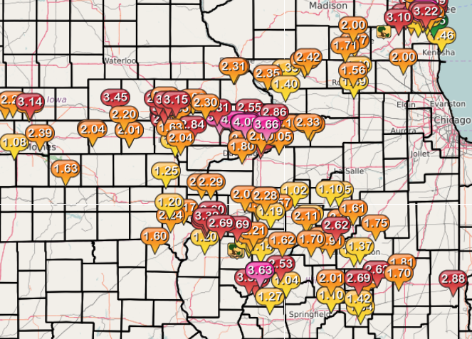
Figure 2: Local Multiple-Radar/ Multiple-Sensor 24-Rainfall |
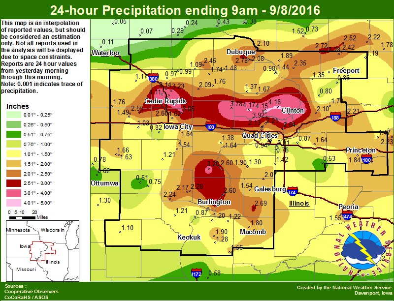
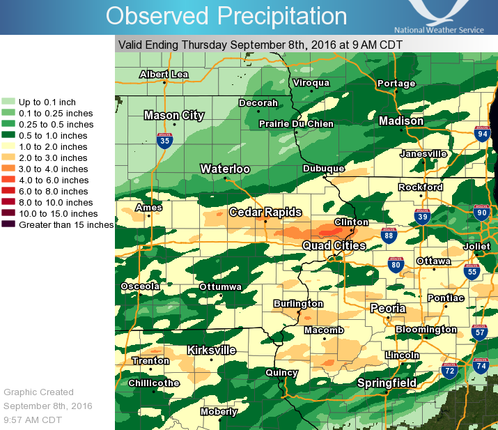
Figure 3: Regional 24-hr Rainfall ending 9 am 09/08/16 |
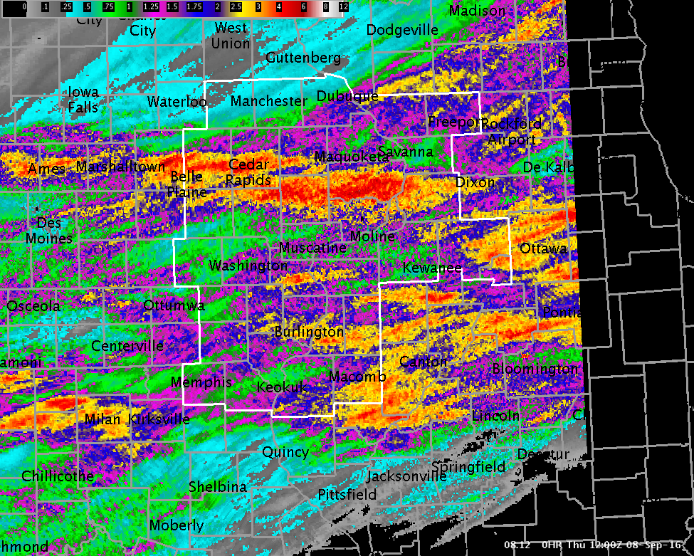
Figure 4: Multiple-Radar/ Multiple-Sensor Estimated Rainfall Ending 7 am 09/08/16 |
Public Information Statement National Weather Service Quad Cities IA IL 830 AM CDT Thu Sep 8 2016 ...Highest 24-hr Rainfall Reports... Observations are collected from a variety of sources with varying equipment and exposures. Not all data listed are considered official. Location Amount Time/Date Provider De Witt 4.54 in 0800 AM 09/08 COOP 2 ENE Calamus 4.17 in 0700 AM 09/08 COCORAHS De Witt 0.9 N 4.15 in 0700 AM 09/08 COCORAHS Dewitt 1.4 WNW 3.92 in 0700 AM 09/08 COCORAHS Fulton 3.85 in 0600 AM 09/08 COCORAHS Clinton 1.7 W 3.80 in 0700 AM 09/08 COCORAHS Lowden 3.78 in 0700 AM 09/08 COOP 2 NE Cedar Rapids 3.77 in 0555 AM 09/08 COCORAHS Ms Rvr At Burlington 3.32 in 0800 AM 09/08 USARMY-COE 1 ENE Marion 3.32 in 0813 AM 09/08 CWOP Burlington 3.25 in 0714 AM 09/08 COCORAHS 1 E Hiawatha 3.24 in 0821 AM 09/08 CWOP Clinton Arpt 3.23 in 0356 AM 09/08 AWOS 1 NW Marion 3.23 in 0657 AM 09/08 COCORAHS Burlington 2S 2.91 in 0700 AM 09/08 COOP Davenport NWS 2.87 in 0700 AM 09/08 COOP Fulton L/D 13 2.86 in 0800 AM 09/08 USARMY-COE Cedar Rvr At Cedar Bluff 2.84 in 0800 AM 09/08 USGS Oxford Mills 2.81 in 0730 AM 09/08 COOP Stronghurst 2.69 in 0823 AM 09/08 CWOP Roseville 2.69 in 0700 AM 09/08 COCORAHS Palo 2.67 in 0815 AM 09/08 USGS Cedar Rapids Arpt 2.65 in 0652 AM 09/08 ASOS Gladstone L/d 18 2.60 in 0800 AM 09/08 COOP Swisher 2.60 in 0700 AM 09/08 COOP 1 W Port Byron 2.54 in 0700 AM 09/08 COCORAHS Midway 2.47 in 0820 AM 09/08 CWOP 1 NW Oneco 2.42 in 0700 AM 09/08 COCORAHS Elizabeth 2.35 in 0630 AM 09/08 COOP 2 WSW Cedar Rapids 2.35 in 0700 AM 09/08 COCORAHS 1 NE Sterling 2.33 in 0824 AM 09/08 CWOP Dubuque #3 2.31 in 0700 AM 09/08 COOP 1 NNE Olin 2.30 in 0805 AM 09/08 CWOP New Boston L/d 17 2.29 in 0810 AM 09/08 USARMY-COE Iowa Rvr At Wapello 2.29 in 0800 AM 09/08 USGS 2 NNE Mc Connell 2.28 in 0700 AM 09/08 COCORAHS Salem 1 S 2.24 in 0700 AM 09/08 COOP Davenport Arpt 2.23 in 0652 AM 09/08 ASOS Park View 2.21 in 0700 AM 09/08 COCORAHS 1 WSW New London 2.17 in 0700 AM 09/08 COCORAHS Eldridge 2.13 in 0800 AM 09/08 COCORAHS Eldridge 2.12 in 0700 AM 09/08 COCORAHS Morrison 2.10 in 0700 AM 09/08 COOP 3 SSW Anamosa 2.09 in 0600 AM 09/08 COOP Dubuque Arpt 2.08 in 0653 AM 09/08 ASOS Alexis 2.07 in 0700 AM 09/08 COOP 3 E Iowa City 2.04 in 0821 AM 09/08 CWOP Le Claire L/d 14 1.90 in 0800 AM 09/08 COOP Galena 1.89 in 0700 AM 09/08 COOP Macomb 1.88 in 0700 AM 09/08 COOP Duck Crk Near West Lake 1.88 in 0815 AM 09/08 USGS Belle Plaine 1.76 in 0700 AM 09/08 COOP Unionville 1.75 in 0821 AM 09/08 CWOP Rock Rvr At Como 1.74 in 0700 AM 09/08 USARMY-COE Monticello 1.74 in 0700 AM 09/08 COOP Galena Territory 1.73 in 0820 AM 09/08 CWOP Prairie City 1.73 in 0600 AM 09/08 COOP Ms Rvr At Dubuque 1.72 in 0730 AM 09/08 USARMY-COE Macomb Arpt 1.71 in 0655 AM 09/08 AWOS 1 SW Coleta 1.70 in 0700 AM 09/08 COCORAHS 1 SE Davenport 1.67 in 0700 AM 09/08 COCORAHS Ms Rvr At Fairport 1.66 in 0730 AM 09/08 USARMY-COE Cedar Crk Near Oakland Mills 1.66 in 0730 AM 09/08 USGS Iowa City 1.64 in 0700 AM 09/08 COOP 1 WSW Spring Grove 1.63 in 0700 AM 09/08 COCORAHS Sigourney 1.63 in 0700 AM 09/08 COOP North Liberty 1.62 in 0700 AM 09/08 COCORAHS Edwards Rvr At New Boston 1.62 in 0730 AM 09/08 USARMY-COE 3 NNW Ely 1.60 in 0820 AM 09/08 CWOP Augusta 1.56 in 0541 AM 09/08 COOP 2 SSE Davenport 1.56 in 0530 AM 09/08 COCORAHS Hoover Creak Near West Branc 1.55 in 0745 AM 09/08 USGS 4 N Haskins 1.54 in 0700 AM 09/08 COCORAHS 1 SE Princeton 1.53 in 0700 AM 09/08 COCORAHS Princeton 1.53 in 0700 AM 09/08 COOP 3 W Pleasant Grove 1.52 in 0806 AM 09/08 CWOP Center Point 1.52 in 0600 AM 09/08 COCORAHS Illinois City L/d 16 1.51 in 0800 AM 09/08 COOP 1 NNE North Liberty 1.49 in 0817 AM 09/08 CWOP Marengo 2.6 SSW 1.49 in 0700 AM 09/08 COCORAHS Cascade 1.48 in 0700 AM 09/08 COOP 1 WSW Davenport 1.48 in 0700 AM 09/08 COCORAHS 3 ENE Bentley 1.46 in 0807 AM 09/08 CWOP 1 W Riverdale 1.45 in 0732 AM 09/08 CWOP 1 S Princeton 1.43 in 0700 AM 09/08 COCORAHS 1 NNE Credit Island 1.42 in 0530 AM 09/08 COCORAHS 2 ESE Scioto Mills 1.41 in 0813 AM 09/08 CWOP 2 N Muscatine 1.38 in 0700 AM 09/08 COOP 1 WNW Freeport 1.37 in 0630 AM 09/08 COCORAHS 4 W Maquoketa 1.37 in 0700 AM 09/08 COOP 1 N Stockton 1.35 in 0900 PM 09/07 COOP Monticello Arpt 1.33 in 0655 AM 09/08 AWOS Bellevue L/d 12 1.31 in 0800 AM 09/08 USARMY-COE 2 ENE Argyle Lake State 1.31 in 0700 AM 09/08 COCORAHS Keosauqua 1.31 in 0715 AM 09/08 COOP Aledo 1.30 in 0700 AM 09/08 COCORAHS Iowa City Arpt 1.30 in 0652 AM 09/08 ASOS Henderson Crk At Oquawka 1.29 in 0730 AM 09/08 USGS Bentley 1.28 in 0645 AM 09/08 COOP Riverdale 1.28 in 0630 AM 09/08 COCORAHS Rock Island L/d 15 1.26 in 0800 AM 09/08 COOP Big Bureau Crk Near Princeto 1.24 in 0745 AM 09/08 USGS 1 ESE Edmore 1.23 in 0800 AM 09/08 HADS 1 ESE Dubuque 1.22 in 0822 AM 09/08 CWOP 1 WNW Eldridge 1.21 in 0822 AM 09/08 CWOP Donnellson 1.21 in 0700 AM 09/08 COOP Vinton 1.21 in 0815 AM 09/08 USGS Washington 1.21 in 0700 AM 09/08 COOP Farmington 1.20 in 0807 AM 09/08 RAWS 2 NE Colusa 1.20 in 0530 AM 09/08 COCORAHS Davis 1.19 in 0630 AM 09/08 COCORAHS Vinton 1.17 in 0700 AM 09/08 COOP Coralville Dam 1.14 in 0800 AM 09/08 USARMY-COE Iowa Rvr At Iowa City 1.14 in 0800 AM 09/08 USGS 1 E Dubuque 1.12 in 0822 AM 09/08 CWOP Keokuk L/d 19 1.11 in 0810 AM 09/08 USARMY-COE Memphis 1.10 in 0600 AM 09/08 COOP Moline 1.09 in 0730 AM 09/08 COCORAHS Urbana 1.08 in 0815 AM 09/08 CWOP 1 E Dubuque 1.08 in 0821 AM 09/08 CWOP 1 ESE Freeport 1.08 in 0700 AM 09/08 COCORAHS Green Rvr At Geneseo 1.06 in 0730 AM 09/08 USGS Ms Rvr At Keithsburg 1.06 in 0730 AM 09/08 USARMY-COE English Rvr Near Parnell 1.05 in 0800 AM 09/08 USGS Rock Rvr Near Joslin 1.03 in 0745 AM 09/08 USGS Cedar Rvr At Conesville 1.00 in 0800 AM 09/08 USGS Pope Creek Near Keithsburg 1.00 in 0730 AM 09/08 USGS Coggon 0.99 in 0630 AM 09/08 COOP Fort Madison Arpt 0.99 in 0655 AM 09/08 AWOS 3 NNE Lafayette 0.97 in 0630 AM 09/08 COCORAHS Williamsburg 0.95 in 0813 AM 09/08 CWOP 1 W Moline 0.94 in 0700 AM 09/08 COCORAHS Iowa Rvr At Columbus Jct 0.93 in 0800 AM 09/08 USARMY-COE 1 ESE Coal Valley 0.91 in 0700 AM 09/08 COCORAHS Freeport Arpt 0.90 in 0655 AM 09/08 AWOS Fort Madison 0.9 NE 0.87 in 0700 AM 09/08 COCORAHS 1 NW Geneseo 0.87 in 0500 AM 09/08 COCORAHS Shannon 0.86 in 0700 AM 09/08 COCORAHS 1 WNW Oakville 0.86 in 0800 AM 09/08 USGS Quad City Intl Arpt 0.85 in 0652 AM 09/08 ASOS Williamsburg 0.83 in 0822 AM 09/08 CWOP Fairfield Arpt 0.82 in 0655 AM 09/08 AWOS 2 WSW Chadwick 0.80 in 0700 AM 09/08 COCORAHS Ms Rvr Near Fort Madison 0.79 in 0730 AM 09/08 USARMY-COE Wapsi Rvr At Oxford Jct 0.78 in 0745 AM 09/08 USGS Rock Rvr At Moline 0.77 in 0730 AM 09/08 USARMY-COE 2 S Beckwith 0.75 in 0700 AM 09/08 COCORAHS Big Bear Creek At Ladora 0.75 in 0800 AM 09/08 USGS Freeport 0.73 in 0730 AM 09/08 COOP |
 |
Media use of NWS Web News Stories is encouraged! Please acknowledge the NWS as the source of any news information accessed from this site. |
|