Dangerous and extreme heat will remain across portions of the Central U.S. this week, persisting across the Mid to Lower Mississippi Valleys, Gulf Coast, Southern Plains and portions of Texas. A heat wave over the Southwest will intensify late this week. Severe thunderstorms and flash flooding will spread from the Great Lakes/Ohio Valley to the Mid-Atlantic and Northeast the next few days. Read More >
Overview
|
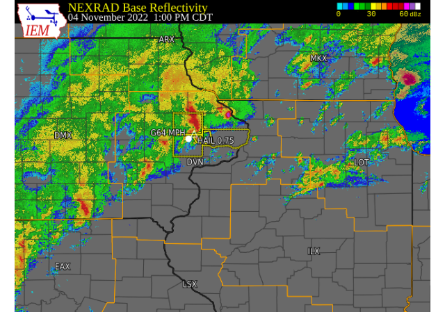
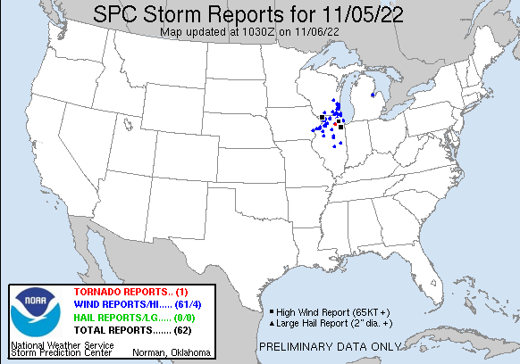
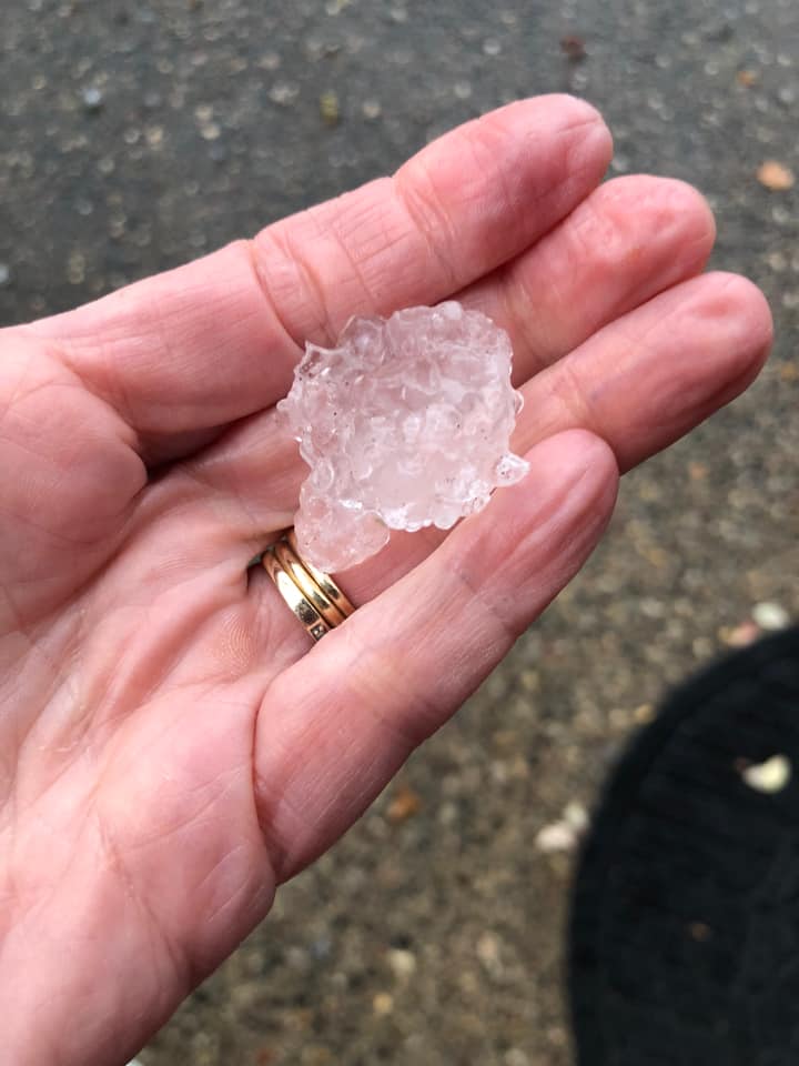
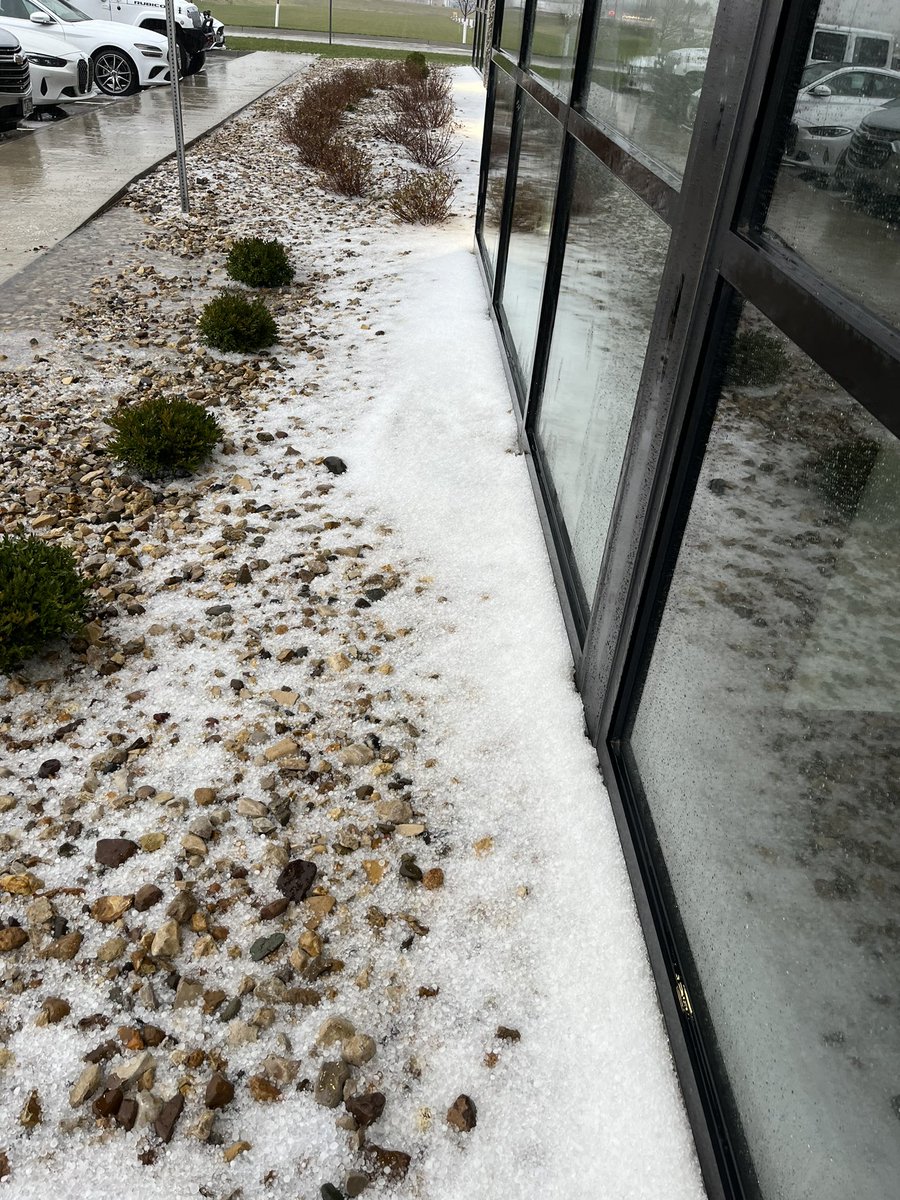
A strong low pressure system impacted much of the region from the morning of November 4th through November 5th. This storm not only brought along much needed rainfall, but it also brought along some severe weather. The morning of November 4th, a few cells grew strong rather quickly and resulted in sporadic reports of hail between quarter and ping pong ball sized. Some reports of wind damage were also received. The bulk of the precipitation fell on the 4th. A large swath of 1-4" of rain fell, with the highest totals along an axis from Ottumwa to Dubuque IA. As much of the rain began to move out the morning of November 5th, the dry lot associated with the cold front punched through the area. That, coupled with some likely influence from the low level jet, led to a rapidly strengthening line of severe convection. While little to no lightning was noted with this line, multiple reports of severe wind gusts and damage were received. |
 7am 11/5 Surface Analysis (Weather Prediction Center |
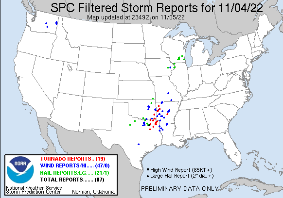
Storm Reports
| Interactive Storm Report Map (IEM) | SPC Storm Reports 11/4 | SPC Storm Reports 11/5 |
 |
 |
 |
| Storm Reports | Highest Winds |
PRELIMINARY LOCAL STORM REPORT...SUMMARY
NATIONAL WEATHER SERVICE QUAD CITIES IA IL
1056 AM CDT SAT NOV 5 2022

..TIME...   ...EVENT...      ...CITY LOCATION...     ...LAT.LON...
..DATE...   ....MAG....      ..COUNTY LOCATION..ST.. ...SOURCE....
            ..REMARKS..

0730 AM     HEAVY RAIN       4 S DEWITT              41.77N 90.53W
11/05/2022  M1.71 INCH       SCOTT              IA   MESONET

            MESONET STATION DEWI4 3.9 S DEWITT.

0730 AM     HEAVY RAIN       2 ENE DAVENPORT         41.57N 90.58W
11/05/2022  M1.97 INCH       SCOTT              IA   COCORAHS

            COCORAHS STATION IA-ST-58 DAVENPORT 2.1 N.

0730 AM     HEAVY RAIN       MARION                  42.04N 91.59W
11/05/2022  M2.05 INCH       LINN               IA   COCORAHS

            COCORAHS STATION IA-LN-59 MARION.

0730 AM     HEAVY RAIN       1 NNW MONTICELLO MUNICI 42.24N 91.17W
11/05/2022  M2.08 INCH       JONES              IA   CO-OP OBSERVER

            CO-OP OBSERVER STATION MCLI4 MONTICELLO.

0730 AM     HEAVY RAIN       1 ESE OASIS             41.70N 91.37W
11/05/2022  M2.67 INCH       JOHNSON            IA   COCORAHS

            COCORAHS STATION IA-CD-7 WEST BRANCH 2.0
            NNW.

0733 AM     HEAVY RAIN       1 ESE INDEPENDENCE      42.47N 91.88W
11/05/2022  M1.71 INCH       BUCHANAN           IA   COCORAHS

            COCORAHS STATION IA-BC-11 INDEPENDENCE 0.6
            ESE.

0740 AM     HEAVY RAIN       1 NNE BETTENDORF        41.58N 90.47W
11/05/2022  M1.93 INCH       SCOTT              IA   TRAINED SPOTTER

            24-HR TOTAL.

0740 AM     HEAVY RAIN       1 W GALENA              42.42N 90.44W
11/05/2022  M2.00 INCH       JO DAVIESS         IL   TRAINED SPOTTER

            24-HR TOTAL.

0745 AM     HEAVY RAIN       GORDONS FERRY           42.38N 90.49W
11/05/2022  M1.55 INCH       DUBUQUE            IA   MESONET

            MESONET STATION NVRI4 GORDONS FERRY.

0745 AM     HEAVY RAIN       WAUPETON                42.67N 90.88W
11/05/2022  M1.66 INCH       DUBUQUE            IA   MESONET

            MESONET STATION WPNI4 WAUPETON.

0746 AM     HEAVY RAIN       2 NNE CRANSTON          41.41N 91.25W
11/05/2022  M2.09 INCH       MUSCATINE          IA   MESONET

            MESONET STATION TT595 CEDAR RIVER TNC SWAMP.

0748 AM     HEAVY RAIN       1 E DUBUQUE REGIONAL AR 42.40N 90.70W
11/05/2022  M1.93 INCH       DUBUQUE            IA   ASOS

            ASOS STATION KDBQ DUBUQUE ARPT.

0755 AM     TSTM WND GST     MUSCATINE MUNICIPALITY  41.37N 91.15W
11/05/2022  M59 MPH          MUSCATINE          IA   AWOS

            AWOS STATION KMUT MUSCATINE ARPT.

0756 AM     HEAVY RAIN       1 SE CLINTON MUNICIPALI 41.82N 90.32W
11/05/2022  M2.07 INCH       CLINTON            IA   AWOS

            AWOS STATION KCWI CLINTON ARPT.

0757 AM     HEAVY RAIN       2 ESE DYERSVILLE        42.47N 91.09W
11/05/2022  M1.95 INCH       DUBUQUE            IA   COCORAHS

            COCORAHS STATION IA-DB-26 DYERSVILLE 1.7
            ESE.

0800 AM     HEAVY RAIN       6 W ILLINOIS CITY       41.42N 91.02W
11/05/2022  M1.57 INCH       ROCK ISLAND        IL   MESONET

            MESONET STATION ILNI2 2.9 E MUSCATINE.

0800 AM     HEAVY RAIN       1 ESE INDEPENDENCE      42.47N 91.88W
11/05/2022  M1.80 INCH       BUCHANAN           IA   MESONET

            MESONET STATION EW8796 INDEPENDENCE.

0800 AM     HEAVY RAIN       4 N FULTON              41.92N 90.15W
11/05/2022  M1.89 INCH       WHITESIDE          IL   MESONET

            MESONET STATION FLTI2 DAM 13.

0800 AM     HEAVY RAIN       IOWA CITY MUNICIPALITY  41.63N 91.55W
11/05/2022  M1.93 INCH       JOHNSON            IA   ASOS

            ASOS STATION KIOW IOWA CITY ARPT.

0800 AM     HEAVY RAIN       1 SW FREDONIA           41.28N 91.35W
11/05/2022  M2.17 INCH       LOUISA             IA   MESONET

            MESONET STATION CJTI4 0.5 SW FREDONIA.

0800 AM     HEAVY RAIN       SIGOURNEY               41.33N 92.20W
11/05/2022  M2.20 INCH       KEOKUK             IA   CO-OP OBSERVER

            CO-OP OBSERVER STATION SGYI4 SIGOURNEY.

0800 AM     HEAVY RAIN       2 SSW BELLE PLAINE      41.87N 92.28W
11/05/2022  M2.22 INCH       BENTON             IA   MESONET

            MESONET STATION BPLI4 IOWA RIVER

0800 AM     HEAVY RAIN       1 NNE FAIRFIELD         41.02N 91.96W
11/05/2022  M2.23 INCH       JEFFERSON          IA   CO-OP OBSERVER

            CO-OP OBSERVER STATION FRFI4 FAIRFIELD.

0800 AM     HEAVY RAIN       1 SSE DEWITT            41.81N 90.54W
11/05/2022  M2.44 INCH       CLINTON            IA   CO-OP OBSERVER

            CO-OP OBSERVER STATION DWTI4 DE WITT.

0810 AM     HEAVY RAIN       3 ENE DAVENPORT         41.57N 90.55W
11/05/2022  M2.03 INCH       SCOTT              IA   MESONET

            MESONET STATION 3356D 3 S MOUNT JOY.

0810 AM     HEAVY RAIN       1 WSW WILLIAMSBURG      41.66N 92.02W
11/05/2022  M2.46 INCH       IOWA               IA   MESONET

            MESONET STATION 1384D WILLIAMSBURG.

0811 AM     HEAVY RAIN       2 ENE ROCKDALE          42.47N 90.65W
11/05/2022  M1.69 INCH       DUBUQUE            IA   MESONET

            MESONET STATION EW0216 DUBUQUE.

0811 AM     HEAVY RAIN       MOUNT CARROLL           42.09N 89.98W
11/05/2022  M3.11 INCH       CARROLL            IL   MESONET

            MESONET STATION CW0216 MT. CARROLL.

0812 AM     HEAVY RAIN       CEDAR RAPIDS MUNICIPALI 41.88N 91.72W
11/05/2022  M2.16 INCH       LINN               IA   ASOS

            ASOS STATION KCID CEDAR RAPIDS ARPT.

0813 AM     HEAVY RAIN       2 NNE IOWA CITY         41.68N 91.52W
11/05/2022  M1.87 INCH       JOHNSON            IA   MESONET

            MESONET STATION AV990 IOWA CITY.

0813 AM     HEAVY RAIN       1 NNE OAKDALE           41.71N 91.59W
11/05/2022  M2.12 INCH       JOHNSON            IA   TRAINED SPOTTER


0815 AM     HEAVY RAIN       1 NE MARION             42.05N 91.57W
11/05/2022  M1.50 INCH       LINN               IA   MESONET

            MESONET STATION DW8270 MARION.

0815 AM     HEAVY RAIN       2 SSE ANAMOSA           42.08N 91.27W
11/05/2022  M1.59 INCH       JONES              IA   MESONET

            MESONET STATION ANSI4 WAPSIPINICON RIVER

0815 AM     HEAVY RAIN       1 SSE MANCHESTER        42.47N 91.45W
11/05/2022  M1.65 INCH       DELAWARE           IA   MESONET

            MESONET STATION MCHI4 1.1 SE MANCHESTER

0815 AM     HEAVY RAIN       FREEPORT ALBERTUS       42.25N 89.58W
11/05/2022  M1.77 INCH       STEPHENSON         IL   AWOS

            AWOS STATION KFEP FREEPORT ARPT.

0815 AM     HEAVY RAIN       1 NNW SIGOURNEY         41.34N 92.21W
11/05/2022  M1.77 INCH       KEOKUK             IA   MESONET

            MESONET STATION FW6954 SIGOURNEY.

0815 AM     HEAVY RAIN       2 S MOUNT JOY           41.59N 90.55W
11/05/2022  M1.79 INCH       SCOTT              IA   MESONET

            MESONET STATION AU989 FLAGSTAFF CHESHIRE.

0815 AM     HEAVY RAIN       1 W CEDAR RAPIDS        41.98N 91.70W
11/05/2022  M1.81 INCH       LINN               IA   MESONET

            MESONET STATION GW1087 CEDAR RAPIDS.

0815 AM     HEAVY RAIN       INDEPENDENCE            42.47N 91.89W
11/05/2022  M1.88 INCH       BUCHANAN           IA   MESONET

            MESONET STATION FW1476 INDEPENDENCE.

0815 AM     HEAVY RAIN       1 NW ELDRIDGE           41.65N 90.59W
11/05/2022  M1.91 INCH       SCOTT              IA   MESONET

            MESONET STATION DW9509 ELDRIDGE.

0815 AM     HEAVY RAIN       WASHINGTON              41.29N 91.69W
11/05/2022  M1.92 INCH       WASHINGTON         IA   MESONET

            MESONET STATION WSHNG WASHINGTON.

0815 AM     HEAVY RAIN       1 N INDEPENDENCE        42.48N 91.89W
11/05/2022  M2.00 INCH       BUCHANAN           IA   MESONET

            MESONET STATION FW0270 INDEPENDENCE.

0815 AM     HEAVY RAIN       1 E MUSCATINE           41.42N 91.05W
11/05/2022  M2.04 INCH       MUSCATINE          IA   MESONET

            MESONET STATION FW3897 MUSCATINE.

0815 AM     HEAVY RAIN       1 WSW CENTRAL CITY      42.20N 91.53W
11/05/2022  M2.17 INCH       LINN               IA   MESONET

            MESONET STATION AV079 CENTRAL CITY.

0815 AM     HEAVY RAIN       2 SW DAVENPORT MUNICIPA 41.59N 90.61W
11/05/2022  M2.48 INCH       SCOTT              IA   MESONET

            MESONET STATION DW3396 DAVENPORT.

0815 AM     HEAVY RAIN       1 WNW GALENA TERRITORY  42.41N 90.35W
11/05/2022  M2.76 INCH       JO DAVIESS         IL   MESONET

            MESONET STATION CW7485 MIDDLEBURG.

0816 AM     HEAVY RAIN       1 SE GRANDVIEW          41.26N 91.17W
11/05/2022  M1.58 INCH       LOUISA             IA   MESONET

            MESONET STATION FW6676 GRANDVIEW.

0816 AM     HEAVY RAIN       1 E DUBUQUE             42.51N 90.67W
11/05/2022  M1.91 INCH       DUBUQUE            IA   MESONET

            MESONET STATION DW8823 DUBUQUE.

0816 AM     HEAVY RAIN       DAVENPORT MUNICIPALITY  41.62N 90.58W
11/05/2022  M2.14 INCH       SCOTT              IA   ASOS

            ASOS STATION KDVN DAVENPORT ARPT.

0816 AM     HEAVY RAIN       2 E HIAWATHA            42.05N 91.65W
11/05/2022  M2.19 INCH       LINN               IA   MESONET

            MESONET STATION GW1068 CEDAR RAPIDS.

0817 AM     HEAVY RAIN       1 W MOLINE QUAD-CITY AI 41.45N 90.52W
11/05/2022  M1.67 INCH       ROCK ISLAND        IL   ASOS

            ASOS STATION KMLI QUAD CITY INTL ARPT.

0817 AM     HEAVY RAIN       2 WNW DUBUQUE           42.51N 90.72W
11/05/2022  M1.73 INCH       DUBUQUE            IA   MESONET

            MESONET STATION FW6257 DUBUQUE.

0817 AM     HEAVY RAIN       1 SE BETTENDORF         41.56N 90.46W
11/05/2022  M2.26 INCH       SCOTT              IA   MESONET

            MESONET STATION GW1737 BETTENDORF.

0818 AM     HEAVY RAIN       WINTHROP                42.47N 91.73W
11/05/2022  M2.11 INCH       BUCHANAN           IA   MESONET

            MESONET STATION FW1482 WINTHROP.

0818 AM     HEAVY RAIN       3 SE SHARON CENTER      41.53N 91.62W
11/05/2022  M2.33 INCH       JOHNSON            IA   MESONET

            MESONET STATION FW8567 RIVERSIDE.

0818 AM     HEAVY RAIN       2 ESE SCIOTO MILLS      42.33N 89.63W
11/05/2022  M3.10 INCH       STEPHENSON         IL   MESONET

            MESONET STATION EW5530 FREEPORT.

0819 AM     HEAVY RAIN       1 NW ELDRIDGE           41.64N 90.59W
11/05/2022  M2.32 INCH       SCOTT              IA   MESONET

            MESONET STATION GW0281 ELDRIDGE.

0819 AM     HEAVY RAIN       3 E IOWA CITY           41.65N 91.48W
11/05/2022  M2.41 INCH       JOHNSON            IA   MESONET

            MESONET STATION CW5749 IOWA CITY.

0820 AM     HEAVY RAIN       1 ESE SHUEYVILLE        41.85N 91.64W
11/05/2022  M2.05 INCH       JOHNSON            IA   MESONET

            MESONET STATION FW4695 CEDAR RAPIDS.

0825 AM     HEAVY RAIN       2 W GENOA BLUFF         41.72N 92.18W
11/05/2022  M2.25 INCH       IOWA               IA   TRAINED SPOTTER

            24-HR TOTAL.

0825 AM     TSTM WND GST     LOWDEN                  41.86N 90.92W
11/05/2022  E50 MPH          CEDAR              IA   CO-OP OBSERVER


0835 AM     TSTM WND DMG     1 ENE COAL VALLEY       41.45N 90.43W
11/05/2022                   HENRY              IL   LAW ENFORCEMENT

            TREE DOWN ON RTE 6 NORTHEAST OF COAL VALLEY.
            TIME ESTIMATED FROM RADAR.

0843 AM     TSTM WND DMG     COLONA                  41.49N 90.35W
11/05/2022                   HENRY              IL   LAW ENFORCEMENT

            POWER LINES DOWN IN COLONA, TIME ESTIMATED
            FROM RADAR.

0849 AM     TSTM WND DMG     RAPIDS CITY             41.58N 90.34W
11/05/2022                   ROCK ISLAND        IL   LAW ENFORCEMENT

            REPORT OF TREE DOWN IN RAPIDS CITY PER LAW
            ENFORCEMENT.

0850 AM     HEAVY RAIN       2 NNE CREDIT ISLAND     41.52N 90.60W
11/05/2022  M2.24 INCH       SCOTT              IA   TRAINED SPOTTER

            24 HR TOTAL.

0851 AM     TSTM WND DMG     GALVA                   41.17N 90.04W
11/05/2022                   HENRY              IL   LAW ENFORCEMENT

            CORRECTS PREVIOUS TSTM WND DMG REPORT FROM
            GALVA. POWER LINES AND POLES DOWN IN GALVA,
            RELAYED FROM LAW ENFORCEMENT. TIME ESTIMATED
            FROM RADAR.

0901 AM     HEAVY RAIN       3 NNE CEDAR RAPIDS      42.01N 91.66W
11/05/2022  M2.28 INCH       LINN               IA   TRAINED SPOTTER

            STORM TOTAL.

0903 AM     HEAVY RAIN       3 ENE CHARLIE HEATH MEM 40.59N 91.84W
11/05/2022  M1.80 INCH       CLARK              MO   TRAINED SPOTTER

            STORM TOTAL.

0906 AM     HEAVY RAIN       1 W BETTENDORF          41.56N 90.49W
11/05/2022  M2.00 INCH       SCOTT              IA   TRAINED SPOTTER

            24-HR TOTAL.

0925 AM     TSTM WND DMG     TAMPICO                 41.63N 89.78W
11/05/2022                   WHITESIDE          IL   LAW ENFORCEMENT

            REPORT OF TREE TAKING DOWN POWER LINES IN
            TAMPICO. TIME ESTIMATED FROM RADAR.

0930 AM     HEAVY RAIN       3 W MOUNT STERLING      40.62N 92.00W
11/05/2022  M1.90 INCH       VAN BUREN          IA   TRAINED SPOTTER

            24-HR TOTAL.

0930 AM     TSTM WND GST     5 N TAMPICO             41.70N 89.79W
11/05/2022  M58 MPH          WHITESIDE          IL   TRAINED SPOTTER


0930 AM     TSTM WND DMG     DEER GROVE              41.61N 89.68W
11/05/2022                   WHITESIDE          IL   LAW ENFORCEMENT

            TREE DOWN NEAR HOOVER RD AND YATES RD IN
            DEER GROVE. TIME ESTIMATED FROM RADAT.

0938 AM     TSTM WND DMG     ROCK FALLS              41.77N 89.69W
11/05/2022                   WHITESIDE          IL   PUBLIC

            APPLE TREES REPORTED DOWN IN TOWN.

0944 AM     HEAVY RAIN       1 N WILLIAMSBURG        41.68N 92.01W
11/05/2022  M2.75 INCH       IOWA               IA   TRAINED SPOTTER

            STORM TOTAL.

0947 AM     HEAVY RAIN       3 SSW CENTER JUNCTION   42.08N 91.10W
11/05/2022  M2.56 INCH       JONES              IA   TRAINED SPOTTER

            STORM TOTAL.

0950 AM     TSTM WND DMG     LANARK                  42.10N 89.83W
11/05/2022                   CARROLL            IL   LAW ENFORCEMENT

            WIRES PULLED DOWN FROM A HOUSE IN LANARK.
            TIME ESTIMATED FROM RADAR.

0954 AM     TSTM WND GST     3 N STOCKTON            42.40N 90.00W
11/05/2022  M76 MPH          JO DAVIESS         IL   CO-OP OBSERVER

            VERY STRONG WIND GUST ON WIND SENSOR 24 FOOT
            OFF GROUND...MANY SMALL BRANCHES DOWN.

1008 AM     HEAVY RAIN       1 W MORRISON            41.81N 89.98W
11/05/2022  M2.18 INCH       WHITESIDE          IL   TRAINED SPOTTER

            24-HR TOTAL.

1012 AM     TSTM WND DMG     FREEPORT                42.29N 89.63W
11/05/2022                   STEPHENSON         IL   LAW ENFORCEMENT

            SEVERAL REPORTS OF TREES AND POWER LINES
            DOWN IN THE FREEPORT METRO AREA.

1019 AM     HEAVY RAIN       CANTRIL                 40.64N 92.07W
11/05/2022  M1.50 INCH       VAN BUREN          IA   TRAINED SPOTTER

            24-HR TOTAL.

1020 AM     HEAVY RAIN       2 NNW OAKLAND MILLS     40.97N 91.63W
11/05/2022  M1.93 INCH       HENRY              IA   TRAINED SPOTTER
|
PUBLIC INFORMATION STATEMENT NATIONAL WEATHER SERVICE QUAD CITIES IA IL 748 PM CDT SAT NOV 5 2022 ...HIGHEST WIND REPORTS... LOCATION SPEED TIME/DATE LAT/LON 3 N STOCKTON 76 MPH 0954 AM 11/05 42.40N/90.00W STOCKTON 76 MPH 0955 AM 11/05 42.40N/89.99W MUSCATINE ARPT 59 MPH 0755 AM 11/05 41.37N/91.15W MUSCATINE ARPT 59 MPH 0755 AM 11/05 41.37N/91.15W 5 N TAMPICO 58 MPH 0930 AM 11/05 41.70N/89.79W MACOMB 52 MPH 0945 AM 11/05 40.47N/90.69W QUAD CITY INTL ARPT 51 MPH 0834 AM 11/05 41.45N/90.52W LOWDEN 50 MPH 0825 AM 11/05 41.86N/90.92W ELDRIDGE 49 MPH 0839 AM 11/05 41.64N/90.59W FREEPORT ARPT 49 MPH 1015 AM 11/05 42.25N/89.58W BURLINGTON ARPT 49 MPH 1041 AM 11/05 40.77N/91.13W MAQUOKETA 48 MPH 0850 AM 11/05 42.07N/90.68W MACOMB ARPT 47 MPH 0218 PM 11/05 40.52N/90.65W DUBUQUE ARPT 46 MPH 0915 AM 11/05 42.40N/90.70W DAVENPORT ARPT 46 MPH 0236 PM 11/05 41.62N/90.58W TIPTON 44 MPH 0810 AM 11/05 41.64N/91.13W MOUNT PLEASANT ARPT 44 MPH 0850 AM 11/05 40.95N/91.52W DUBUQUE 44 MPH 1157 AM 11/05 42.46N/90.77W BURLINGTON 44 MPH 1215 PM 11/05 40.81N/91.10W CLINTON ARPT 44 MPH 0112 PM 11/05 41.82N/90.32W DAVENPORT 44 MPH 0225 PM 11/05 41.60N/90.68W STERLING/ROCK FALLS ARPT 43 MPH 0342 PM 11/05 41.75N/89.67W ELDRIDGE 42 MPH 0230 PM 11/05 41.66N/90.57W STOCKTON 3 NNE 40 MPH 0700 AM 11/05 42.40N/90.00W WASHINGTON ARPT 40 MPH 1215 PM 11/05 41.27N/91.67W KEOKUK ARPT 40 MPH 0215 PM 11/05 40.47N/91.42W ELDRIDGE 39 MPH 1200 PM 11/05 41.65N/90.59W MONMOUTH 39 MPH 0135 PM 11/05 40.93N/90.63W CEDAR RAPIDS ARPT 38 MPH 1124 AM 11/05 41.88N/91.72W FLAGSTAFF CHESHIRE 38 MPH 1215 PM 11/05 41.59N/90.55W ROBINS 38 MPH 0130 PM 11/05 42.10N/91.64W DE WITT 38 MPH 0225 PM 11/05 41.83N/90.57W SAVANNA ARPT 38 MPH 0304 PM 11/05 42.05N/90.12W INDEPENDENCE 38 MPH 0330 PM 11/05 42.47N/91.88W FAIRFIELD ARPT 37 MPH 1035 AM 11/05 41.03N/91.97W IOWA CITY ARPT 37 MPH 1053 AM 11/05 41.63N/91.55W NEW LONDON 36 MPH 0740 AM 11/05 40.97N/91.34W QUAD CITIES 36 MPH 1110 AM 11/05 41.52N/90.51W ANAMOSA 36 MPH 1130 AM 11/05 42.07N/91.34W FREEPORT 35 MPH 1248 PM 11/05 42.33N/89.63W RIVERSIDE 35 MPH 0104 PM 11/05 41.53N/91.62W DUBUQUE 35 MPH 0500 PM 11/05 42.49N/90.73W CAMBRIDGE 34 MPH 1150 AM 11/05 41.35N/90.23W OHIO 34 MPH 0425 PM 11/05 41.57N/89.40W IOWA CITY US 218 33 MPH 1130 AM 11/05 41.66N/91.60W MONMOUTH 33 MPH 0120 PM 11/05 40.93N/90.72W STRONGHURST 33 MPH 0227 PM 11/05 40.74N/90.91W BUFFALO 32 MPH 1003 AM 11/05 40.98N/91.41W FORT MADISON ARPT 32 MPH 1015 AM 11/05 40.67N/91.32W MOUNT PLEASANT 32 MPH 1035 AM 11/05 40.90N/91.56W FAIRBANK 32 MPH 1130 AM 11/05 42.64N/92.05W BIG BEND 32 MPH 1210 PM 11/05 41.63N/90.04W CEDAR RAPIDS I-380 32 MPH 0145 PM 11/05 41.98N/91.67W 2.5 S CORALVILLE (WEATHERSTE 32 MPH 0200 PM 11/05 41.66N/91.60W DUBUQUE 32 MPH 0336 PM 11/05 42.51N/90.67W LONE TREE (WEATHERSTEM) 31 MPH 1110 AM 11/05 41.49N/91.43W MARION 31 MPH 1145 AM 11/05 42.05N/91.57W CEDAR RAPIDS US 30 31 MPH 1220 PM 11/05 41.93N/91.68W DUBUQUE 31 MPH 1224 PM 11/05 42.47N/90.65W DEWITT 31 MPH 0305 PM 11/05 41.82N/90.54W 1 NNE AURORA 31 MPH 0340 PM 11/05 42.64N/91.72W |
Rain Reports
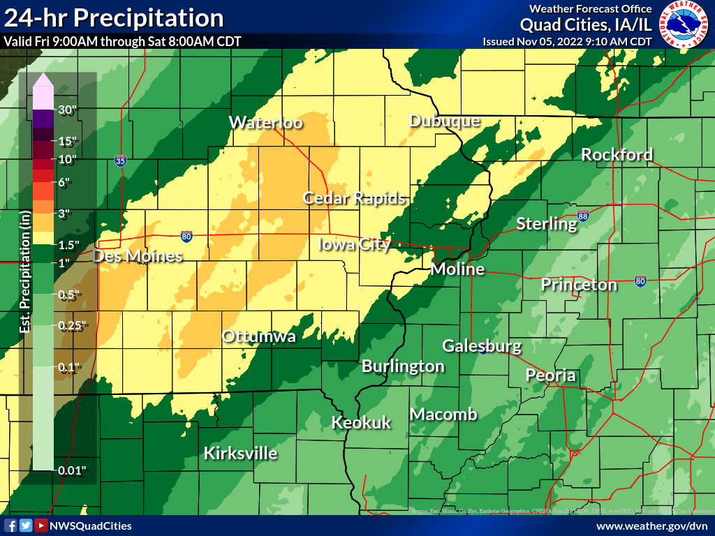
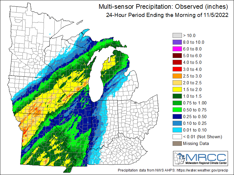
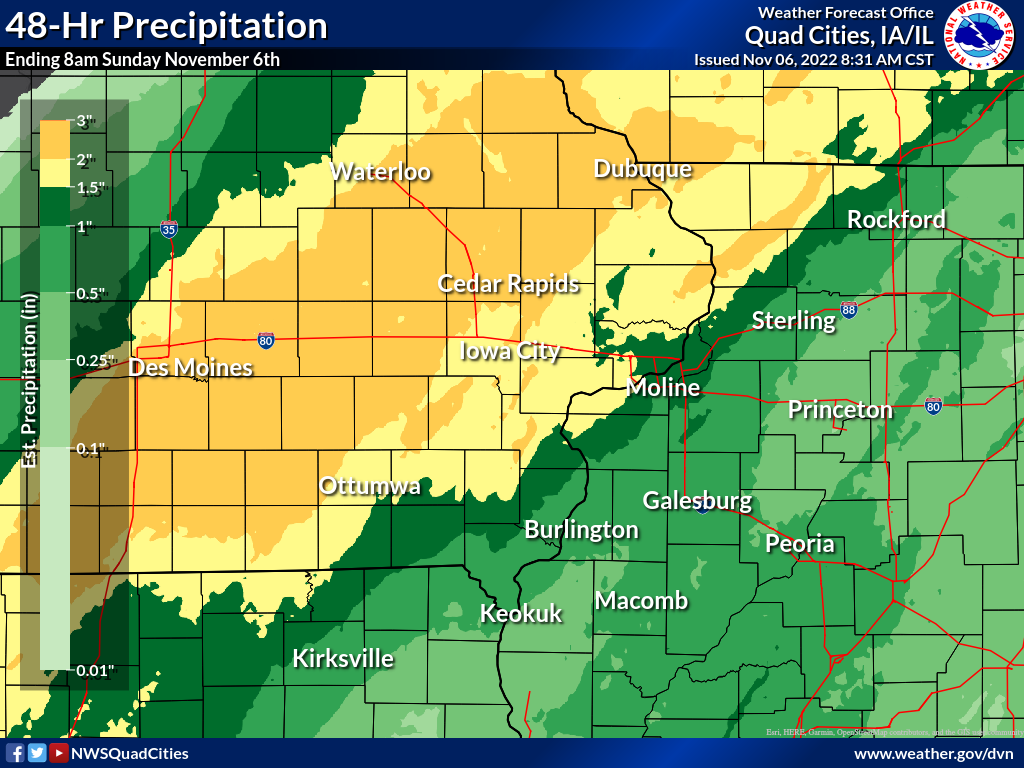
| Local Rainfall Analysis | Regional Rainfall Analysis | 48-hr Rainfall Analysis (click here for reports) |
 |
 |
 |
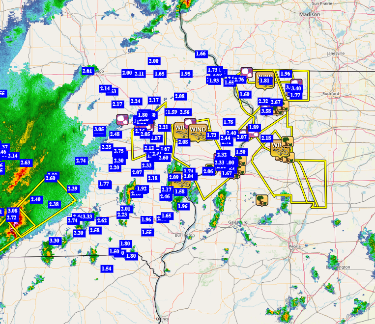
24 hour precipitation reports (in Inches),
for eastern Iowa, northwest and west central Illinois,
and northeast Missouri. Reported between Midnight and 9 AM,
Saturday November 05, 2022.

....IOWA....
Columbus Jct 2 SSW               3.00
Allerton 2 S                     2.80
Centerville 0 NE                 2.72
West Branch 2.0 NNW              2.67
Park View 0.2 WSW                2.63
Belle Plaine                     2.62
Iowa City                        2.60
Pella AWOS 2 WSW                 2.58
Central City 6.7 W               2.55
Bettendorf 1.2 WNW               2.51
Marengo 3.6 N                    2.48
De Witt                          2.44
De Witt 5.4 ENE                  2.40
Iowa City 2.3 E                  2.25
Center Point 0.6 NNW             2.24
Fairfield                        2.23
Anamosa 3 SSW                    2.22
Lisbon 0.1 W                     2.21
North English                    2.20
Sigourney                        2.20
Ainsworth 7.4 N                  2.18
Manchester                       2.18
North Liberty 0.7 SSW            2.15
Cedar Rapids Arpt                2.15
Washington                       2.15
Davenport Arpt                   2.15
Davenport 0.9 WNW                2.11
Washington 5.8 SW                2.10
Parnell 0.1 SSW                  2.10
Tipton 0.3 ESE                   2.08
Monticello 1 E                   2.08
Wellman 4.0 E                    2.07
Salem 3.1 ESE                    2.06
Marion 0.4 NNW                   2.05
Dubuque #3 7 SW                  2.05
Williamsburg                     2.05
Elkader 6SSW                     2.05
Marengo 2.6 SSW                  2.04
Dubuque 1.0 SE                   2.04
Oskaloosa AWOS 9 ESE             2.04
Dubuque Arpt                     2.02
Grinnell AWOS 2 SSW              2.02
Fairfield 5.7 NNE                2.01
Dundee 1.4 NNE                   2.00
Marshalltown 1 NW                2.00
Davenport 2.1 N                  1.97
Marshalltown ASOS 4 N            1.97
Wapello 5.4 SE                   1.96
Muscatine 3.0 NE                 1.96
Iowa City Arpt                   1.96
Mt Pleasant 1 SSW                1.96
Dyersville 1.7 ESE               1.95
Ottumwa ASOS 6 NNW               1.91
Marengo                          1.90
Dubuque LD11                     1.89
Davenport 1.0 NE                 1.88
Solon 0.4 WNW                    1.87
Cedar Rapids 3.3 WNW             1.87
Lowden                           1.87
Cedar Rapids 4.1 NW              1.83
Cedar Rapids 2.7 NE              1.80
Newton 1 NE                      1.80
Charlotte 1.9 WNW                1.78
Hiawatha 0.9 SW                  1.74
Muscatine 2N                     1.74
Calamus 2.0 NE                   1.73
Robins 0.8 SE                    1.71
Independence 0.6 ESE             1.71
Guttenberg Dam 10                1.70
Yarmouth 1.9 SW                  1.65
Marion 1.7 NNW                   1.65
Mount Auburn 2.2 NNW             1.63
NWS Johnston* 5 NNW              1.60
Salem 1S                         1.55
Fayette 1 NW                     1.55
Waterloo ASOS 5 NW               1.46
Rickardsville 0.2 W              1.45
Oelwein AWOS                     1.45
Maquoketa                        1.31
Bellevue 0.3 SSW                 1.25
Bellevue LD12                    1.20
Donnellson                       1.17
Fort Madison 0.9 NE              1.00
Burlington 6.5 SSW               0.88
Perry 0 W                        0.78
Burlington Arpt                  0.66
Keokuk LD19                      0.58
Hampton 1 N                      0.53
Mason City ASOS 6 W              0.09
Boone 1 SSW                      0.09
Mason City 1 NNE                 0.02
....ILLINOIS....
Freeport 1.5 E                   3.14
Freeport                         3.13
Lanark 5.3 N                     2.67
Davis 2.7 N                      2.67
Freeport 4.3 W                   2.46
Mount Carroll 6.8 NNW            2.32
East Dubuque 1.7 SE              2.15
Fulton LD13                      2.03
Winslow 4.3 ESE                  1.96
New Boston LD17                  1.95
Stockton 3 NNE                   1.81
Stockton 3.4 NNE                 1.72
Quad City Arpt                   1.66
Moline 0.7 NNE                   1.64
Hanover 0.2 NW                   1.60
Aledo                            1.43
Elizabeth                        1.41
Morrison 3.2 E                   1.18
Coal Valley 1.9 SE               1.14
Gladstone LD18                   1.10
Coal Valley 2.6 E                1.09
Coleta 1.4 SSW                   1.09
Geneseo 2.0 NW                   0.88
New Windsor 2.0 N                0.88
Rockford Arpt                    0.87
Prophetstown 0.2 SW              0.84
Sterling 5.9 NNE                 0.78
Peoria Arpt                      0.63
Lincoln NWS                      0.60
Altona                           0.58
Colchester 3.5 NE                0.57
Dallas City 3.0 SSE              0.57
Romeoville                       0.54
Stronghurst 0.4 SSW              0.52
Jacksonville Arpt                0.51
Mundelein                        0.48
Tuscola                          0.46
Ottawa 4 SW                      0.46
Bloomington Airport              0.45
Quincy Arpt                      0.40
Decatur Airport                  0.39
La Harpe                         0.38
Augusta                          0.38
Joliet Arpt                      0.36
Walnut 5.3 ENE                   0.33
McNabb 1.4 NW                    0.29
Streator 3 SE                    0.28
Galesburg                        0.27
St Anne                          0.26
Prairie City 2S                  0.26
Kewanee 1 E                      0.25
Ogden                            0.23
Mendota 2 SE                     0.21
Steward                          0.15
Princeton 1.1 SE                 0.13
Princeton                        0.13
Rochelle Arpt                    0.00
....MISSOURI....
Chillicothe Arpt                 2.32
Kirksville Arpt                  1.99
Memphis                          1.54
Columbia Arpt                    1.05
....WISCONSIN....
Sullivan-NWS 2 SE                3.08
Whitewater                       2.89
Brodhead 1 SW                    2.05
Madison Arpt                     1.93
Darlington                       1.90
Prairie du Chien AWOS            1.87
Beloit-College                   1.85
Monroe 1 W                       1.70
Viroqua                          1.65
Watertown-Arpt                   1.64
Allenton-WWTP .6 NW              1.61
Delavan-1 W-WWTP 1 W             1.40
La Crosse WFO                    1.01
Environment
SPC EVENT REVIEW PAGES: 11/04/2022 | 11/05/2022
SPC Categorical/Tornado/Hail/Wind Outlooks
| 11/4/2022 | 11/4/2022 | 11/4/2022 | 11/4/2022 |
 |
 |
 |
 |
| SPC Categorical Outlook | Tornado Outlook | Wind Outlook | Hail Outlook |
DVN Observed Sounding Analysis
 |
 |
 |
| 11/4 12Z DAVENPORT, IA SOUNDING | 11/5 00Z DAVENPORT, IA SOUNDING | 11/4 12Z DAVENPORT, IA SOUNDING |
SPC Mesoscale Discussions
  |
| MCD 1918 and 1927 |
Additional Information
Pictures
 |
 |
||
| Clinton, IA (Courtesy Jacqueline Adair) | Cedar Rapids, IA (Courtesy Brett Pierce) |
 |
Media use of NWS Web News Stories is encouraged! Please acknowledge the NWS as the source of any news information accessed from this site. |
|