
Dangerous heat will expand from the Gulf Coast into the Southern Plains and Desert Southwest through week's end. Additional extreme heat impacting the Pacific Northwest will shift to the northern Plains by the weekend. Tropical Storm Bertha is expected to continue to impact portions of the northern Gulf Coast from the western Florida Panhandle to southeastern Louisiana through tonight. Read More >
Overview
|
Snow fell across much of northeast Iowa and northern Illinois early Saturday, as an area of low pressure tracked east over Missouri. Snowfall amounts generally between 1 and 3 inches were common, with the higher amounts falling along and north of highway 30.
Additional snow fell over portions of eastern Iowa and northwest Illinois late Saturday afternoon and evening. The highest totals between 2 and 4 inches fell along a line from Washington county in Iowa, to northern Mercer and southern Rock Island counties in Illinois. |
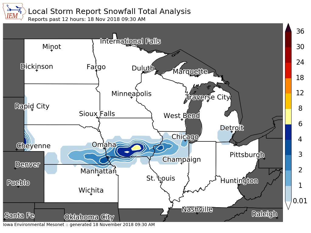
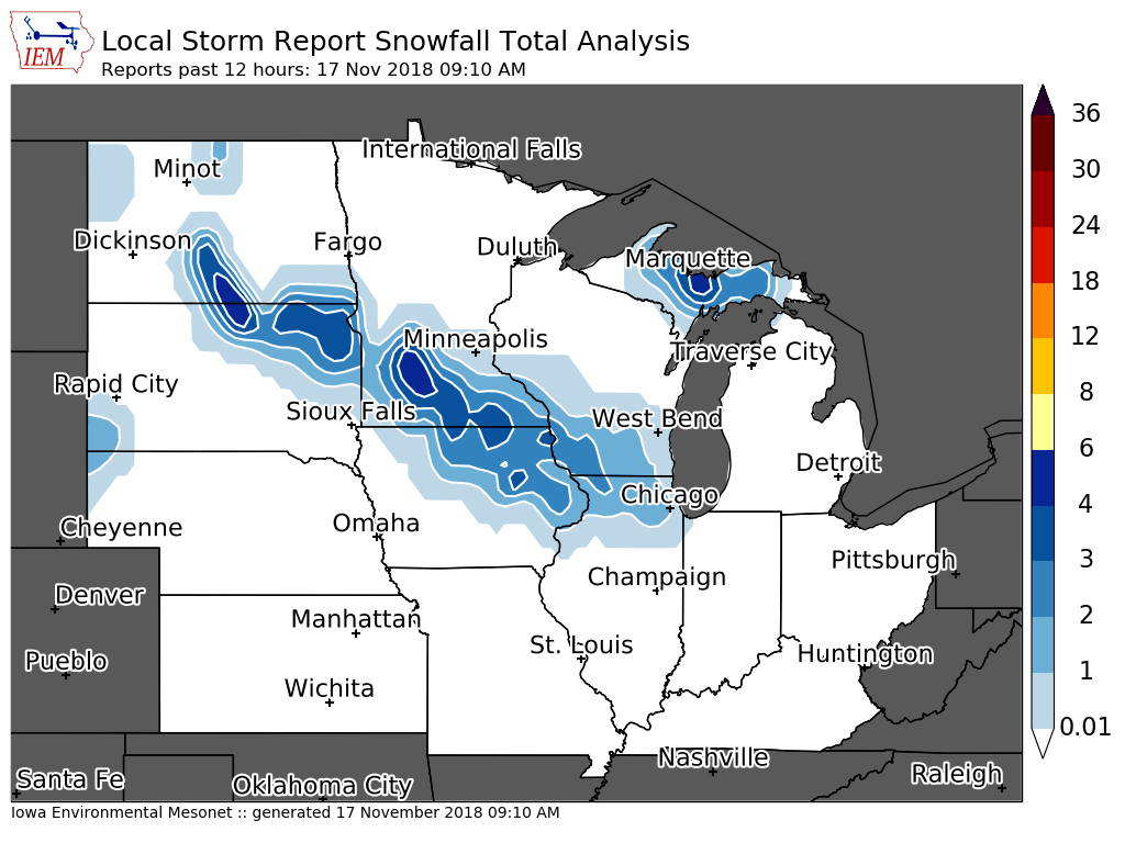 Midwest Snowfall Analysis - Courtesy Iowa Environmental Mesonet (IEM) |
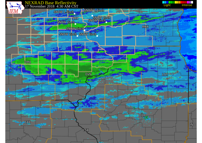
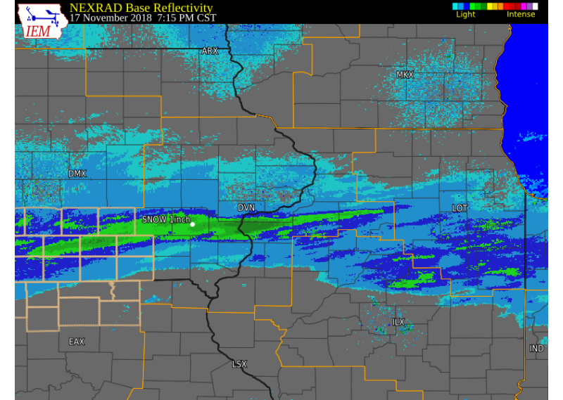
Radar:
 |
|||
| Interactive Web Link (Morning) | Multi Radar Multi Sensor (MRMS) Morning Radar Loop (click bottom right for fullscreen) | ||
 |
|||
| Interactive Web Link (Afternoon and Evening) | Multi Radar Multi Sensor (MRMS) Evening Radar Loop (click bottom right for fullscreen) |
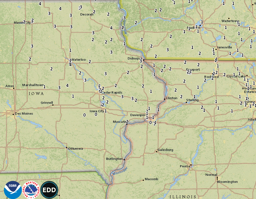
Storm Reports
 |
|
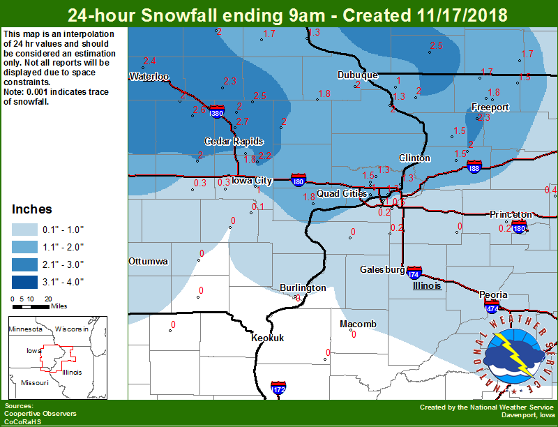 |
| Interactive Map Link (Morning) | Midwest Snow Analysis Courtesy Iowa Environmental Mesonet |
Local Snowfall (Morning) |
|
 |
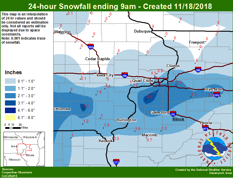 |
| Interactive Web Link (Afternoon and Evening) | Midwest Snow Analysis Courtesy of Iowa Environmental Mesonet | Local Snowfall (Afternoon and Evening) |
PRELIMINARY LOCAL STORM REPORT...SUMMARY
NATIONAL WEATHER SERVICE QUAD CITIES IA IL
1008 AM CST SAT NOV 17 2018

..TIME...   ...EVENT...      ...CITY LOCATION...     ...LAT.LON...
..DATE...   ....MAG....      ..COUNTY LOCATION..ST.. ...SOURCE....
            ..REMARKS..

0900 AM     SNOW             2 E VINTON              42.17N 91.99W
11/17/2018  M3.0 INCH        BENTON             IA   TRAINED SPOTTER

            SNOW TOTAL.

0900 AM     SNOW             1S EDGEWOOD             42.64N 91.40W
11/17/2018  M2.8 INCH        DELAWARE           IA   TRAINED SPOTTER

            SNOW TOTAL.

0700 AM     SNOW             ROBINS                  42.07N 91.67W
11/17/2018  M2.7 INCH        LINN               IA   COCORAHS

            COCORAHS STATION IA-LN-23, ROBINS.

0700 AM     SNOW             1 E VINTON              42.17N 92.00W
11/17/2018  M2.6 INCH        BENTON             IA   CO-OP OBSERVER

            CO-OP OBSERVER STATION VNTI4, VINTON.

0500 AM     SNOW             COGGON                  42.28N 91.53W
11/17/2018  M2.5 INCH        LINN               IA   CO-OP OBSERVER

            CO-OP OBSERVER STATION CGGI4, COGGON.

0706 AM     SNOW             HIAWATHA                42.05N 91.68W
11/17/2018  M2.5 INCH        LINN               IA   TRAINED SPOTTER


0823 AM     SNOW             STANWOOD                41.89N 91.15W
11/17/2018  M2.5 INCH        CEDAR              IA   TRAINED SPOTTER

            STORM TOTAL.

0903 AM     SNOW             LOWDEN                  41.86N 90.92W
11/17/2018  M2.5 INCH        CEDAR              IA   CO-OP OBSERVER

            STORM TOTAL.

0926 AM     SNOW             1 NW CENTER GROVE       42.49N 90.73W
11/17/2018  M2.5 INCH        DUBUQUE            IA   TRAINED SPOTTER

            STORM TOTAL.

0404 AM     SNOW             2 WNW DUBUQUE           42.52N 90.72W
11/17/2018  E2.3 INCH        DUBUQUE            IA   TRAINED SPOTTER


0700 AM     SNOW             SHANNON                 42.15N 89.74W
11/17/2018  M2.3 INCH        CARROLL            IL   COCORAHS

            COCORAHS STATION IL-CR-13, SHANNON.

0823 AM     SNOW             1 N INDEPENDENCE        42.48N 91.89W
11/17/2018  M2.3 INCH        BUCHANAN           IA   TRAINED SPOTTER


0844 AM     SNOW             MARION                  42.03N 91.59W
11/17/2018  M2.3 INCH        LINN               IA   BROADCAST MEDIA

            STORM TOTAL.

0727 AM     SNOW             SOLON                   41.80N 91.49W
11/17/2018  M2.2 INCH        JOHNSON            IA   TRAINED SPOTTER


0900 AM     SNOW             STOCKTON                42.36N 90.06W
11/17/2018  M2.1 INCH        JO DAVIESS         IL   CO-OP OBSERVER

            SNOW TOTAL.

0500 AM     SNOW             2 NNW MOUNT AUBURN      42.29N 92.11W
11/17/2018  M2.0 INCH        BENTON             IA   COCORAHS

            COCORAHS STATION IA-BT-11, 2 NNW MOUNT
            AUBURN.

0607 AM     SNOW             DUBUQUE REGIONAL ARPT   42.40N 90.71W
11/17/2018  M2.0 INCH        DUBUQUE            IA   OFFICIAL NWS OBS

            SNOWFALL PAST 6 HOURS.

0630 AM     SNOW             2 NW ELIZABETH          42.33N 90.25W
11/17/2018  M2.0 INCH        JO DAVIESS         IL   CO-OP OBSERVER

            CO-OP OBSERVER STATION EZBI2, ELIZABETH.

0700 AM     SNOW             1 SSW COLETA            41.89N 89.81W
11/17/2018  M2.0 INCH        WHITESIDE          IL   COCORAHS

            COCORAHS STATION IL-WD-8, 1 SW COLETA.

0700 AM     SNOW             2 ESE FAIRVIEW          42.08N 91.30W
11/17/2018  M2.0 INCH        JONES              IA   CO-OP OBSERVER

            CO-OP OBSERVER STATION AMOI4, 3 SSW ANAMOSA.

0705 AM     SNOW             2 NNE CEDAR RAPIDS      42.01N 91.66W
11/17/2018  M2.0 INCH        LINN               IA   TRAINED SPOTTER


0709 AM     SNOW             2 N CEDAR RAPIDS        42.01N 91.66W
11/17/2018  M2.0 INCH        LINN               IA   BROADCAST MEDIA

            AVERAGE MEASUREMENT FROM SIX READINGS.

0824 AM     SNOW             2 E CEDAR RAPIDS        41.98N 91.63W
11/17/2018  M2.0 INCH        LINN               IA   TRAINED SPOTTER


0847 AM     SNOW             WHEATLAND               41.83N 90.84W
11/17/2018  E2.0 INCH        CLINTON            IA   TRAINED SPOTTER


0652 AM     SNOW             2 NW FREEPORT           42.30N 89.66W
11/17/2018  M1.9 INCH        STEPHENSON         IL   COCORAHS

            COCORAHS STATION IL-SP-25, 1 WNW FREEPORT.

0530 AM     SNOW             ELY                     41.87N 91.58W
11/17/2018  M1.8 INCH        LINN               IA   COCORAHS

            COCORAHS STATION IA-LN-3, ELY.

0700 AM     SNOW             4 NNE MUSCATINE         41.47N 91.04W
11/17/2018  M1.8 INCH        MUSCATINE          IA   CO-OP OBSERVER

            CO-OP OBSERVER STATION MSTI4, 2 N MUSCATINE.

0700 AM     SNOW             CASCADE                 42.30N 91.02W
11/17/2018  M1.8 INCH        DUBUQUE            IA   CO-OP OBSERVER

            CO-OP OBSERVER STATION CASI4, CASCADE.

0700 AM     SNOW             3 NNE MC CONNELL        42.47N 89.72W
11/17/2018  M1.7 INCH        STEPHENSON         IL   COCORAHS

            COCORAHS STATION IL-SP-8, 2 NNE MC CONNELL.

0700 AM     SNOW             1 NE FREEPORT           42.30N 89.62W
11/17/2018  M1.7 INCH        STEPHENSON         IL   MESONET

            MESONET STATION FEEI2, PEC RVR AT FREEPORT.

0927 AM     SNOW             2 NNW NORTH LIBERTY     41.76N 91.62W
11/17/2018  M1.6 INCH        JOHNSON            IA   TRAINED SPOTTER

            STORM TOTAL.

0521 AM     SNOW             1 NNE CEDAR RAPIDS      41.99N 91.66W
11/17/2018  M1.5 INCH        LINN               IA   BROADCAST MEDIA


0630 AM     SNOW             DAVIS                   42.43N 89.42W
11/17/2018  M1.5 INCH        STEPHENSON         IL   COCORAHS

            COCORAHS STATION IL-SP-7, DAVIS.

0700 AM     SNOW             1 E FREEPORT            42.29N 89.61W
11/17/2018  M1.5 INCH        STEPHENSON         IL   COCORAHS

            COCORAHS STATION IL-SP-22, 1 E FREEPORT.

0700 AM     SNOW             3 WSW CHADWICK          42.00N 89.94W
11/17/2018  M1.5 INCH        CARROLL            IL   COCORAHS

            COCORAHS STATION IL-CR-4, 2 WSW CHADWICK.

0755 AM     SNOW             1 WNW MAQUOKETA         42.07N 90.68W
11/17/2018  M1.5 INCH        JACKSON            IA   TRAINED SPOTTER


0800 AM     SNOW             1 NW ELDRIDGE           41.64N 90.59W
11/17/2018  M1.5 INCH        SCOTT              IA   COCORAHS

            COCORAHS STATION IA-ST-30, ELDRIDGE.

0600 AM     SNOW             2 W BLANDING            42.27N 90.42W
11/17/2018  M1.3 INCH        JO DAVIESS         IL   MESONET

            MESONET STATION BLVI4, BELLEVUE L/D 12.

0634 AM     SNOW             PARK VIEW               41.69N 90.54W
11/17/2018  M1.3 INCH        SCOTT              IA   NWS EMPLOYEE


0700 AM     SNOW             1 ENE RIVERDALE         41.54N 90.45W
11/17/2018  M1.3 INCH        SCOTT              IA   COCORAHS

            COCORAHS STATION IA-ST-8, RIVERDALE.

0700 AM     SNOW             2 WNW CHARLOTTE         41.98N 90.50W
11/17/2018  M1.3 INCH        CLINTON            IA   COCORAHS

            COCORAHS STATION IA-CN-17, 1 WNW CHARLOTTE.

0757 AM     SNOW             1 SSW CORDOVA           41.67N 90.33W
11/17/2018  M1.3 INCH        ROCK ISLAND        IL   TRAINED SPOTTER


0700 AM     SNOW             2 SSE DAVENPORT         41.53N 90.59W
11/17/2018  M1.2 INCH        SCOTT              IA   COCORAHS

            COCORAHS STATION IA-ST-4, 2 SSE DAVENPORT.

0712 AM     SNOW             1 SE DAVENPORT          41.54N 90.59W
11/17/2018  M1.2 INCH        SCOTT              IA   COCORAHS

            COCORAHS STATION IA-ST-37, 1 SE DAVENPORT.

0542 AM     SNOW             BELLE PLAINE            41.90N 92.27W
11/17/2018  E1.0 INCH        BENTON             IA   PUBLIC


0606 AM     SNOW             DAVENPORT AIRPORT       41.61N 90.59W
11/17/2018  M1.0 INCH        SCOTT              IA   OFFICIAL NWS OBS

            SNOWFALL PAST 6 HOURS.

0700 AM     SNOW             1 S IOWA CITY           41.65N 91.53W
11/17/2018  M1.0 INCH        JOHNSON            IA   CO-OP OBSERVER

            CO-OP OBSERVER STATION ICYI4, IOWA CITY.

0700 AM     SNOW             GALENA                  42.42N 90.43W
11/17/2018  M1.0 INCH        JO DAVIESS         IL   CO-OP OBSERVER

            CO-OP OBSERVER STATION GPBI2, GALENA.

0800 AM     SNOW             2 NNW WARNER            41.45N 90.40W
11/17/2018  M0.7 INCH        HENRY              IL   COCORAHS

            COCORAHS STATION IL-HY-15, 2 NNW WARNER.

0700 AM     SNOW             2 SE COAL VALLEY        41.43N 90.42W
11/17/2018  M0.5 INCH        HENRY              IL   COCORAHS

            COCORAHS STATION IL-HY-5, 1 ESE COAL VALLEY.

0600 AM     SNOW             PARNELL                 41.58N 92.01W
11/17/2018  M0.3 INCH        IOWA               IA   COCORAHS

            COCORAHS STATION IA-IA-13, PARNELL.

0700 AM     SNOW             2 NNW WILLIAMSTOWN      41.59N 91.75W
11/17/2018  M0.3 INCH        JOHNSON            IA   COCORAHS

            COCORAHS STATION IA-JH-9, 1 NNW
            WILLIAMSTOWN.
*****************************************************************************************************

PRELIMINARY LOCAL STORM REPORT...SUMMARY
NATIONAL WEATHER SERVICE QUAD CITIES IA IL
919 AM CST SUN NOV 18 2018

..TIME...   ...EVENT...      ...CITY LOCATION...     ...LAT.LON...
..DATE...   ....MAG....      ..COUNTY LOCATION..ST.. ...SOURCE....
            ..REMARKS..

0911 AM     SNOW             1 ENE NEW WINDSOR       41.20N 90.44W
11/18/2018  M4.5 INCH        HENRY              IL   TRAINED SPOTTER

            STORM TOTAL.

0700 AM     SNOW             1 N ALEDO               41.22N 90.75W
11/18/2018  M3.5 INCH        MERCER             IL   CO-OP OBSERVER

            CO-OP OBSERVER STATION ALEI2, ALEDO.

0800 AM     SNOW             2 NNE FAIRFIELD         41.03N 91.95W
11/18/2018  M3.5 INCH        JEFFERSON          IA   CO-OP OBSERVER

            CO-OP OBSERVER STATION FRFI4, FAIRFIELD.

0730 AM     SNOW             2 NW GENESEO            41.47N 90.18W
11/18/2018  M2.7 INCH        HENRY              IL   COCORAHS

            COCORAHS STATION IL-HY-8, 1 NW GENESEO.

0700 AM     SNOW             1 WNW PRINCETON         41.38N 89.48W
11/18/2018  M2.6 INCH        BUREAU             IL   CO-OP OBSERVER

            CO-OP OBSERVER STATION PTNI2, PRINCETON.

0700 AM     SNOW             2 N TISKILWA            41.32N 89.50W
11/18/2018  M2.5 INCH        BUREAU             IL   COCORAHS

            COCORAHS STATION IL-BU-8, 2 N TISKILWA.

0604 AM     SNOW             MOLINE QUAD-CITY AIRPOR 41.45N 90.51W
11/18/2018  M2.3 INCH        ROCK ISLAND        IL   OFFICIAL NWS OBS

            STORM TOTAL SINCE 6 PM LAST NIGHT.

0544 AM     SNOW             NEW LONDON              40.93N 91.40W
11/18/2018  M2.2 INCH        HENRY              IA   TRAINED SPOTTER

            EVENT TOTAL.

0600 AM     SNOW             5 NNE BRIGHTON          41.24N 91.77W
11/18/2018  M2.2 INCH        WASHINGTON         IA   COCORAHS

            COCORAHS STATION IA-WS-8, 5 NE BRIGHTON.

0700 AM     SNOW             1 ENE KEWANEE           41.25N 89.90W
11/18/2018  M2.1 INCH        HENRY              IL   CO-OP OBSERVER

            CO-OP OBSERVER STATION KEWI2, 1 E KEWANEE.

0700 AM     SNOW             1 SW NEW LONDON         40.91N 91.43W
11/18/2018  M2.0 INCH        HENRY              IA   COCORAHS

            COCORAHS STATION IA-HY-1, 1 WSW NEW LONDON.

0800 AM     SNOW             SIGOURNEY               41.33N 92.20W
11/18/2018  M2.0 INCH        KEOKUK             IA   CO-OP OBSERVER

            CO-OP OBSERVER STATION SGYI4, SIGOURNEY.

0700 AM     SNOW             1 S DONNELLSON          40.63N 91.57W
11/18/2018  M1.9 INCH        LEE                IA   CO-OP OBSERVER

            CO-OP OBSERVER STATION DNNI4, DONNELLSON.

0700 AM     SNOW             1 W WASHINGTON AIRPORT  41.28N 91.68W
11/18/2018  M1.6 INCH        WASHINGTON         IA   CO-OP OBSERVER

            CO-OP OBSERVER STATION WSHI4, WASHINGTON.

0657 AM     SNOW             1 ENE PRARIE GROVE      40.89N 91.23W
11/18/2018  E1.5 INCH        DES MOINES         IA   PUBLIC


0800 AM     SNOW             LA HARPE                40.58N 90.97W
11/18/2018  M1.5 INCH        HANCOCK            IL   CO-OP OBSERVER

            CO-OP OBSERVER STATION LAHI2, LA HARPE.

0700 AM     SNOW             4 N HASKINS             41.40N 91.54W
11/18/2018  M1.4 INCH        WASHINGTON         IA   COCORAHS

            COCORAHS STATION IA-WS-2, 4 N HASKINS.

0715 AM     SNOW             1 SSW KEWANEE           41.23N 89.93W
11/18/2018  E1.3 INCH        HENRY              IL   TRAINED SPOTTER

            STORM TOTAL.

0500 AM     SNOW             6 W ILLINOIS CITY       41.42N 91.02W
11/18/2018  M1.2 INCH        ROCK ISLAND        IL   MESONET

            MESONET STATION ILNI2, ILLINOIS CITY L/D 16.

0600 AM     SNOW             2 S PRAIRIE CITY AIRPOR 40.59N 90.46W
11/18/2018  M1.2 INCH        MCDONOUGH          IL   CO-OP OBSERVER

            CO-OP OBSERVER STATION PRCI2, 2 S PRAIRIE
            CITY.

0700 AM     SNOW             KEOSAUQUA               40.73N 91.97W
11/18/2018  M1.2 INCH        VAN BUREN          IA   CO-OP OBSERVER

            CO-OP OBSERVER STATION KEQI4, KEOSAUQUA.

0630 AM     SNOW             1 ENE RIVERDALE         41.54N 90.45W
11/18/2018  M1.1 INCH        SCOTT              IA   COCORAHS

            COCORAHS STATION IA-ST-8, RIVERDALE.

0600 AM     SNOW             MEMPHIS                 40.46N 92.17W
11/18/2018  M1.0 INCH        SCOTLAND           MO   CO-OP OBSERVER

            CO-OP OBSERVER STATION MMPM7, MEMPHIS.

0600 AM     SNOW             7 S KINGSTON            40.88N 91.03W
11/18/2018  M1.0 INCH        DES MOINES         IA   MESONET

            MESONET STATION GLDI2, GLADSTONE L/D 18.

0700 AM     SNOW             1 S SALEM               40.83N 91.62W
11/18/2018  M1.0 INCH        HENRY              IA   CO-OP OBSERVER

            CO-OP OBSERVER STATION SLHI4, SALEM 1 S.

0700 AM     SNOW             4 NNE MUSCATINE         41.47N 91.04W
11/18/2018  M1.0 INCH        MUSCATINE          IA   CO-OP OBSERVER

            CO-OP OBSERVER STATION MSTI4, 2 N MUSCATINE.

0800 AM     SNOW             2 NNW WARNER            41.45N 90.40W
11/18/2018  M1.0 INCH        HENRY              IL   COCORAHS

            COCORAHS STATION IL-HY-15, 2 NNW WARNER.

0606 AM     SNOW             1 SE DAVENPORT          41.54N 90.59W
11/18/2018  M0.8 INCH        SCOTT              IA   COCORAHS

            COCORAHS STATION IA-ST-37, 1 SE DAVENPORT.

0700 AM     SNOW             PARK VIEW               41.69N 90.54W
11/18/2018  M0.8 INCH        SCOTT              IA   COCORAHS

            COCORAHS STATION IA-ST-3, PARK VIEW.

0700 AM     SNOW             2 ENE ARGYLE LAKE STATE 40.46N 90.75W
11/18/2018  M0.7 INCH        MCDONOUGH          IL   COCORAHS

            COCORAHS STATION IL-MCD-7, 2 ENE ARGYLE LAKE
            STATE.

0606 AM     SNOW             DAVENPORT AIRPORT       41.61N 90.59W
11/18/2018  M0.6 INCH        SCOTT              IA   OFFICIAL NWS OBS

            STORM TOTAL SINCE 6 PM LAST NIGHT.

0600 AM     SNOW             1 NNW HAMILTON          40.40N 91.37W
11/18/2018  M0.5 INCH        HANCOCK            IL   MESONET

            MESONET STATION EOKI4, KEOKUK L/D 19.

0730 AM     SNOW             3 W RICHMOND            41.46N 91.76W
11/18/2018  M0.5 INCH        WASHINGTON         IA   COCORAHS

            COCORAHS STATION IA-WS-7, 3 W RICHMOND.

0800 AM     SNOW             1 NW ELDRIDGE           41.64N 90.59W
11/18/2018  M0.5 INCH        SCOTT              IA   COCORAHS

            COCORAHS STATION IA-ST-30, ELDRIDGE.
 |
Media use of NWS Web News Stories is encouraged! Please acknowledge the NWS as the source of any news information accessed from this site. |
|

