Overview
|
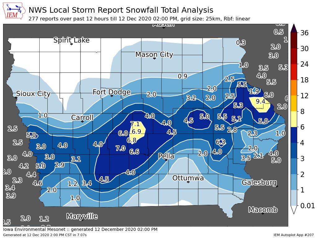
An early season winter storm lead to widespread snowfall throughout the area, with totals around 4-6 inches northwest of a line from Iowa City to Freeport, IL. Closer to Dubuque, totals reached upwards to 8 inches.
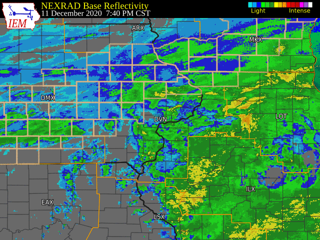
The snow started out as rain, as there was a strong pull of warm and moist air into the area. This rain lasted until around 6:00pm on 12/11, when it started transitioning to snow in our northern part of the CWA. By 6:00am on 12/12, the snow made its way to the Quad Cities area and quickly spread into northwestern IL. The snow was heavy at times, especially right around the area where the rain was transitioning to snow. Visibilities in the heaviest bands were around a 1/2 mile or less.
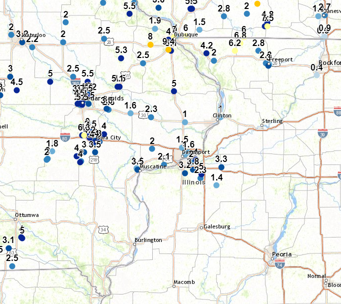
Official National Weather Service Observations Moline: 3.2" Davenport: 1.5" Dubuque: 9.4" ***Cedar Rapids, Iowa City and Burlington do not measure snow as part of their climate records. Please see the Snowfall Amounts and Storm Reports sections for reported snow amounts in these locations.*** |
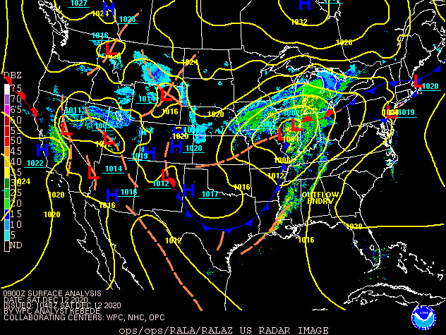 WPC - Surface Map and Radar Loop |
Snowfall Amounts
 |
 |
Storm Reports
Storm Reports Map - Courtesy IEM
|
|
PRELIMINARY LOCAL STORM REPORT...SUMMARY
NATIONAL WEATHER SERVICE QUAD CITIES IA IL
233 PM CST SAT DEC 12 2020

..TIME...   ...EVENT...      ...CITY LOCATION...     ...LAT.LON...
..DATE...   ....MAG....      ..COUNTY LOCATION..ST.. ...SOURCE....
            ..REMARKS..

0900 PM     SNOW             2 WNW FREEPORT          42.30N 89.66W
12/11/2020  M2.3 INCH        STEPHENSON         IL   TRAINED SPOTTER

            THIS UPDATES THE SNOWFALL TOTAL OF 1.5
            INCHES REPORTED EARLIER THIS MORNING.

0345 AM     SNOW             3 E CEDAR RAPIDS        41.97N 91.61W
12/12/2020  M3.5 INCH        LINN               IA   BROADCAST MEDIA

            SNOWFALL TOTAL AS OF 345 AM. AVERAGE YARD
            MEASUREMENT.

0553 AM     SNOW             1 E DUBUQUE REGIONAL AR 42.40N 90.70W
12/12/2020  M5.1 INCH        DUBUQUE            IA   ASOS

            ASOS STATION KDBQ DUBUQUE ARPT.

0600 AM     SNOW             2 ENE DUBUQUE           42.52N 90.65W
12/12/2020  M1.0 INCH        DUBUQUE            IA   MESONET

            MESONET STATION DLDI4 1.8 NW EAST DUBUQUE.

0600 AM     SNOW             RICKARDSVILLE           42.58N 90.88W
12/12/2020  M1.9 INCH        DUBUQUE            IA   TRAINED SPOTTER

            SNOWFALL TOTAL AS OF 6 AM, SNOW WAS STILL
            FALLING WHEN TAKING MEASUREMENT.

0630 AM     SNOW             ELIZABETH               42.32N 90.23W
12/12/2020  M2.0 INCH        JO DAVIESS         IL   CO-OP OBSERVER

            CO-OP OBSERVER STATION EZBI2 ELIZABETH.

0700 AM     SNOW             2 SSW HIAWATHA          42.02N 91.70W
12/12/2020  M2.2 INCH        LINN               IA   TRAINED SPOTTER

            STILL SNOWING, BUT THIS WAS MOST RECENT
            MEASUREMENT.

0729 AM     SNOW             1 NNE MOLINE            41.49N 90.48W
12/12/2020  M2.0 INCH        ROCK ISLAND        IL   NWS EMPLOYEE

            CURRENT MEASURED SNOWFALL.

0736 AM     SNOW             LOWDEN                  41.86N 90.92W
12/12/2020  M2.3 INCH        CEDAR              IA   CO-OP OBSERVER

            CURRENT ACCUMULATED SNOWFALL IN LAST 24
            HOURS.

0757 AM     SNOW             TIFFIN                  41.71N 91.68W
12/12/2020  M4.0 INCH        JOHNSON            IA   PUBLIC

            CORRECTS PREVIOUS SNOW REPORT FROM TIFFIN.
            SOCIAL MEDIA REPORT, SNOW STILL FALLING.

0804 AM     SNOW             2 NNW MUSCATINE         41.44N 91.08W
12/12/2020  M1.4 INCH        MUSCATINE          IA   TRAINED SPOTTER

            HEAVY WET SNOW, STILL FALLING.

0814 AM     SNOW             NORTH LIBERTY           41.74N 91.61W
12/12/2020  M4.0 INCH        JOHNSON            IA   PUBLIC

            SOCIAL MEDIA REPORT.

0831 AM     SNOW             1 NE KALONA             41.50N 91.69W
12/12/2020  M2.0 INCH        WASHINGTON         IA   PUBLIC

            SOCIAL MEDIA REPORT.

0831 AM     SNOW             1 SW CEDAR RAPIDS       41.96N 91.68W
12/12/2020  M5.5 INCH        LINN               IA   PUBLIC

            SOCIAL MEDIA REPORT.

0835 AM     SNOW             3 E DAVENPORT           41.55N 90.55W
12/12/2020  M1.0 INCH        SCOTT              IA   PUBLIC

            CURRENT SNOWFALL, STILL SNOWING.

0849 AM     SNOW             2 SE GALENA TERRITORY   42.38N 90.31W
12/12/2020  M4.2 INCH        JO DAVIESS         IL   TRAINED SPOTTER

            CURRENT SNOWFALL TOTAL.

0850 AM     SNOW             1 SSW COAL VALLEY       41.43N 90.46W
12/12/2020  M3.8 INCH        ROCK ISLAND        IL   PUBLIC

            SOCIAL MEDIA REPORT.

0852 AM     SNOW             GENESEO                 41.45N 90.15W
12/12/2020  M3.3 INCH        HENRY              IL   PUBLIC

            SOCIAL MEDIA REPORT.

0858 AM     SNOW             UNIVERSITY HEIGHTS      41.65N 91.55W
12/12/2020  E2.8 INCH        JOHNSON            IA   TRAINED SPOTTER

            STILL SNWOING.

0859 AM     SNOW             1 E TIFFIN              41.71N 91.66W
12/12/2020  M6.3 INCH        JOHNSON            IA   PUBLIC

            SOCIAL MEDIA REPORT.

0904 AM     SNOW             2 S MC CONNELL          42.40N 89.74W
12/12/2020  M2.8 INCH        STEPHENSON         IL   TRAINED SPOTTER

            SOCIAL MEDIA REPORT, STILL SNOWING.

0908 AM     SNOW             2 NNW NORTH LIBERTY     41.76N 91.62W
12/12/2020  M3.0 INCH        JOHNSON            IA   TRAINED SPOTTER


0909 AM     SNOW             ALBURNETT               42.15N 91.62W
12/12/2020  M5.5 INCH        LINN               IA   PUBLIC

            SOCIAL MEDIA.

0911 AM     SNOW             3 W CEDAR RAPIDS        41.97N 91.73W
12/12/2020  M4.0 INCH        LINN               IA   TRAINED SPOTTER


0912 AM     SNOW             2 E IOWA CITY           41.66N 91.49W
12/12/2020  M3.0 INCH        JOHNSON            IA   TRAINED SPOTTER


0919 AM     SNOW             2 SSE WARNER            41.39N 90.37W
12/12/2020  M5.0 INCH        HENRY              IL   TRAINED SPOTTER


0920 AM     SNOW             MAQUOKETA               42.07N 90.67W
12/12/2020  M5.0 INCH        JACKSON            IA   PUBLIC

            SOCIAL MEDIA REPORT.

0925 AM     SNOW             EPWORTH                 42.45N 90.93W
12/12/2020  M7.8 INCH        DUBUQUE            IA   PUBLIC


0936 AM     SNOW             1 ESE NORTH LIBERTY     41.74N 91.59W
12/12/2020  M3.5 INCH        JOHNSON            IA   TRAINED SPOTTER


0938 AM     SNOW             FREEPORT                42.28N 89.63W
12/12/2020  M3.0 INCH        STEPHENSON         IL   TRAINED SPOTTER


0939 AM     SNOW             2 WSW HIAWATHA          42.03N 91.72W
12/12/2020  M3.7 INCH        LINN               IA   TRAINED SPOTTER


0940 AM     SNOW             HOPKINTON               42.34N 91.25W
12/12/2020  M5.3 INCH        DELAWARE           IA   PUBLIC


0942 AM     SNOW             1 NNE IOWA CITY         41.67N 91.53W
12/12/2020  M3.0 INCH        JOHNSON            IA   PUBLIC


0946 AM     SNOW             1 ENE NORTH ENGLISH     41.52N 92.06W
12/12/2020  M2.0 INCH        IOWA               IA   CO-OP OBSERVER


1000 AM     SNOW             CENTER POINT            42.19N 91.78W
12/12/2020  E2.5 INCH        LINN               IA   PUBLIC

            RELAYED BY LOCAL BROADCAST MEDIA.

1006 AM     SNOW             1 NW CEDAR RAPIDS       41.99N 91.68W
12/12/2020  M5.0 INCH        LINN               IA   PUBLIC

            RELAYED BY BROADCAST MEDIA.

1008 AM     SNOW             NORA                    42.46N 89.94W
12/12/2020  M6.8 INCH        JO DAVIESS         IL   TRAINED SPOTTER


1012 AM     SNOW             DURANT                  41.60N 90.91W
12/12/2020  M2.0 INCH        CEDAR              IA   TRAINED SPOTTER


1012 AM     SNOW             1 SSW VINTON            42.15N 92.03W
12/12/2020  M5.0 INCH        BENTON             IA   TRAINED SPOTTER


1016 AM     SNOW             HILLS                   41.57N 91.54W
12/12/2020  M3.5 INCH        JOHNSON            IA   PUBLIC

            RELAYED BY BROADCAST MEDIA.

1022 AM     SNOW             MARION                  42.04N 91.59W
12/12/2020  M3.2 INCH        LINN               IA   PUBLIC


1024 AM     SNOW             3 N STOCKTON            42.40N 90.00W
12/12/2020  M6.2 INCH        JO DAVIESS         IL   CO-OP OBSERVER


1026 AM     SNOW             1 WNW MARION            42.04N 91.62W
12/12/2020  M3.2 INCH        LINN               IA   TRAINED SPOTTER


1039 AM     SNOW             2 NW CEDAR RAPIDS       41.99N 91.70W
12/12/2020  M4.5 INCH        LINN               IA   BROADCAST MEDIA


1040 AM     SNOW             FULTON                  41.86N 90.16W
12/12/2020  M1.0 INCH        WHITESIDE          IL   TRAINED SPOTTER


1040 AM     SNOW             1 E IOWA CITY           41.66N 91.52W
12/12/2020  M4.0 INCH        JOHNSON            IA   PUBLIC

            SOCIAL MEDIA REPORT.

1043 AM     SNOW             SHARON CENTER           41.57N 91.66W
12/12/2020  M3.0 INCH        JOHNSON            IA   PUBLIC

            SOCIAL MEDIA REPORT.

1048 AM     SNOW             1 NW CENTER GROVE       42.49N 90.73W
12/12/2020  M4.0 INCH        DUBUQUE            IA   TRAINED SPOTTER


1048 AM     SNOW             1 NE MANCHESTER         42.50N 91.44W
12/12/2020  M2.5 INCH        DELAWARE           IA   TRAINED SPOTTER


1059 AM     SNOW             1 E FREEPORT            42.29N 89.62W
12/12/2020  M1.0 INCH        STEPHENSON         IL   PUBLIC


1101 AM     SNOW             1 W ELMIRA              41.72N 91.44W
12/12/2020  M4.0 INCH        JOHNSON            IA   TRAINED SPOTTER


1102 AM     SNOW             1 SW UNIVERSITY HEIGHTS 41.65N 91.57W
12/12/2020  M4.0 INCH        JOHNSON            IA   TRAINED SPOTTER


1109 AM     SNOW             2 ENE HAZLETON          42.63N 91.86W
12/12/2020  M2.0 INCH        BUCHANAN           IA   CO-OP OBSERVER


1111 AM     SNOW             1 N MUSCATINE           41.43N 91.07W
12/12/2020  M3.5 INCH        MUSCATINE          IA   PUBLIC

            SNOWFALL TOTAL BEFORE MELTING, REPORTED ON
            SOCIAL MEDIA.

1112 AM     SNOW             EAST MOLINE             41.51N 90.43W
12/12/2020  M4.0 INCH        ROCK ISLAND        IL   PUBLIC


1115 AM     SNOW             1 NW ORION              41.36N 90.38W
12/12/2020  M2.3 INCH        HENRY              IL   PUBLIC

            SOCIAL MEDIA REPORT.

1118 AM     SNOW             1 ENE DUBUQUE           42.51N 90.67W
12/12/2020  M7.0 INCH        DUBUQUE            IA   PUBLIC

            SOCIAL MEDIA REPORT.

1130 AM     SNOW             1 S HIAWATHA            42.03N 91.68W
12/12/2020  M3.5 INCH        LINN               IA   TRAINED SPOTTER


1133 AM     SNOW             CASCADE                 42.30N 91.01W
12/12/2020  M2.5 INCH        DUBUQUE            IA   PUBLIC

            RELAYED BY BROADCAST MEDIA.

1134 AM     SNOW             KALONA                  41.49N 91.70W
12/12/2020  M4.0 INCH        WASHINGTON         IA   PUBLIC

            RELAYED BY BROADCAST MEDIA.

1140 AM     SNOW             2 W CEDAR RAPIDS        41.98N 91.71W
12/12/2020  M4.0 INCH        LINN               IA   TRAINED SPOTTER


1144 AM     SNOW             LISBON                  41.92N 91.39W
12/12/2020  M2.8 INCH        LINN               IA   TRAINED SPOTTER


1209 PM     SNOW             2 W BETTENDORF          41.57N 90.51W
12/12/2020  M1.6 INCH        SCOTT              IA   NWS EMPLOYEE


1234 PM     HEAVY SNOW       1 NW DUBUQUE REGIONAL A 42.41N 90.73W
12/12/2020  M9.4 INCH        DUBUQUE            IA   OFFICIAL NWS OBS

            STORM TOTAL SNOWFALL. AN ADDITIONAL 4.3
            INCHES FELL BETWEEN 6 AM AND NOON.

1235 PM     SNOW             MOLINE QUAD CIITIE REGI 41.40N 90.55W
12/12/2020  M3.2 INCH        ROCK ISLAND        IL   OFFICIAL NWS OBS

            STORM TOTAL THROUGH NOON.

1236 PM     SNOW             DAVENPORT MUNICIPALITY  41.61N 90.58W
12/12/2020  M1.5 INCH        SCOTT              IA   OFFICIAL NWS OBS

            STORM TOTAL SNOWFALL.

1248 PM     SNOW             2 SSW WILLIAMSTOWN      41.54N 91.74W
12/12/2020  E4.0 INCH        JOHNSON            IA   TRAINED SPOTTER

            SNOW TOTAL.

1252 PM     SNOW             STANWOOD                41.89N 91.15W
12/12/2020  M1.6 INCH        CEDAR              IA   TRAINED SPOTTER

            SNOW TOTAL.

1253 PM     SNOW             1 ENE MONTPELIER        41.47N 90.78W
12/12/2020  M2.1 INCH        SCOTT              IA   TRAINED SPOTTER

            SNOW TOTAL.

1254 PM     SNOW             DEWITT                  41.82N 90.55W
12/12/2020  M1.0 INCH        CLINTON            IA   NWS EMPLOYEE

            SNOW TOTAL.

1256 PM     SNOW             PARNELL                 41.58N 92.01W
12/12/2020  E1.8 INCH        IOWA               IA   TRAINED SPOTTER

            STORM TOTAL SNOWFALL.

1256 PM     SNOW             INDEPENDENCE            42.47N 91.89W
12/12/2020  M2.0 INCH        BUCHANAN           IA   PUBLIC

            RELAYED BY BROADCAST MEDIA.

1257 PM     SNOW             CORALVILLE              41.69N 91.60W
12/12/2020  M4.2 INCH        JOHNSON            IA   PUBLIC


0157 PM     SNOW             2 NNE CEDAR RAPIDS      42.00N 91.66W
12/12/2020  E2.0 INCH        LINN               IA   TRAINED SPOTTER

            SNOW TOTAL.

0158 PM     SNOW             2 WSW CEDAR RAPIDS      41.96N 91.70W
12/12/2020  M2.1 INCH        LINN               IA   TRAINED SPOTTER

            SNOW TOTAL.
|
|
|
 |
Media use of NWS Web News Stories is encouraged! Please acknowledge the NWS as the source of any news information accessed from this site. |
|