Dangerous and extreme heat will remain across portions of the Central U.S. this week, persisting across the Mid to Lower Mississippi Valleys, Gulf Coast, Southern Plains and portions of Texas. A heat wave over the Southwest will intensify late this week. Severe thunderstorms and flash flooding will spread from the Great Lakes/Ohio Valley to the Mid-Atlantic and Northeast the next few days. Read More >
Overview
|
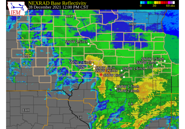
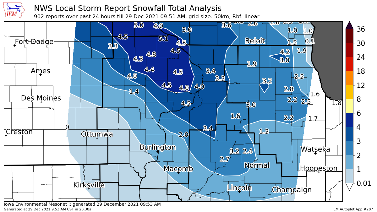
Low pressure tracked across northern Missouri Dec. 28th and produced 2 to 5 inches of heavy, wet snow across parts of the area; especially along and north of I-80. Temperatures warmed into the mid 30s to low 40s by late afternoon, with the precipitation becoming rain and drizzle and the snow beginning to melt and compact. This was the first real snowfall event of the 2021-2022 snow season; with numerous car accidents being reported.
|
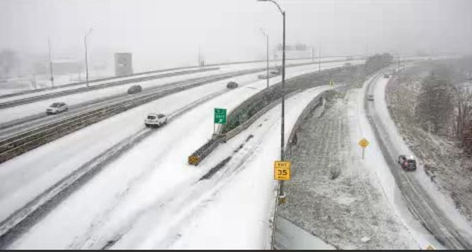 IA DOT - I-380 near Cedar Rapids |
 |
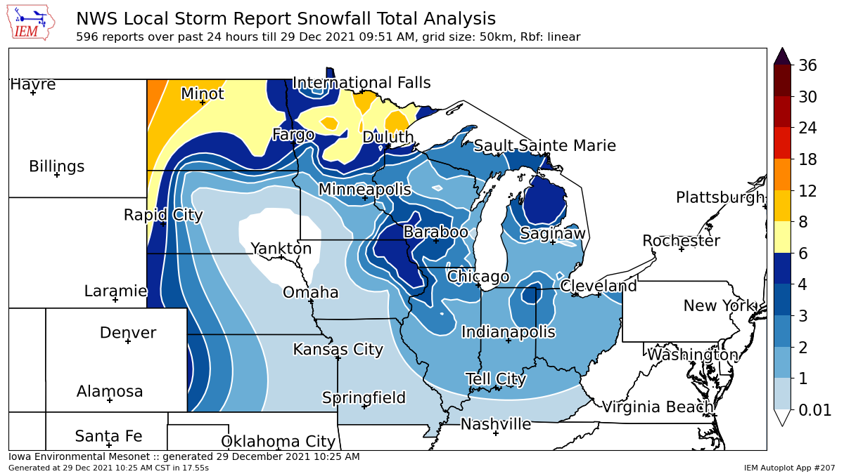 |
| Local Storm Report Analysis (Iowa Environmental Mesonet) | Regional Storm Report Analysis (Iowa Environmental Mesonet) |
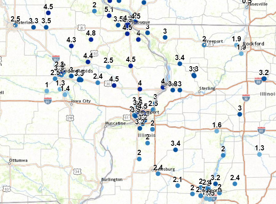
Storm Reports (click for Interactive Map)
|
PRELIMINARY LOCAL STORM REPORT...SUMMARY
NATIONAL WEATHER SERVICE QUAD CITIES IA IL
1116 AM CST WED DEC 29 2021

..TIME...   ...EVENT...      ...CITY LOCATION...     ...LAT.LON...
..DATE...   ....MAG....      ..COUNTY LOCATION..ST.. ...SOURCE....
            ..REMARKS..

0350 PM     SNOW             HOLY CROSS              42.60N 90.99W
12/28/2021  M5.1 INCH        DUBUQUE            IA   PUBLIC

            UPDATED SNOWFALL TOTAL FROM 1250 CST REPORT.
            ADDITIONAL 1.3. NEW TOTAL OF 5.1 AS OF 350
            CST.

0600 PM     SNOW             HOPKINTON               42.35N 91.25W
12/28/2021  M4.8 INCH        DELAWARE           IA   TRAINED SPOTTER


0100 PM     SNOW             2 W BETTENDORF          41.57N 90.51W
12/28/2021  M4.5 INCH        SCOTT              IA   NWS EMPLOYEE


0205 PM     SNOW             1 NW MAQUOKETA          42.07N 90.68W
12/28/2021  M4.5 INCH        JACKSON            IA   TRAINED SPOTTER


0255 PM     SNOW             1 NW CENTER GROVE       42.49N 90.73W
12/28/2021  M4.5 INCH        DUBUQUE            IA   TRAINED SPOTTER


0400 PM     SNOW             1 WNW DUBUQUE           42.51N 90.72W
12/28/2021  M4.5 INCH        DUBUQUE            IA   PUBLIC


0600 PM     SNOW             1 NW DUBUQUE REGIONAL A 42.41N 90.73W
12/28/2021  M4.5 INCH        DUBUQUE            IA   OFFICIAL NWS OBS

            EVENT TOTAL.

1240 PM     SNOW             LOWDEN                  41.86N 90.92W
12/28/2021  M4.5 INCH        CEDAR              IA   CO-OP OBSERVER

            SNOW ENDED AT 1215 - WINDY WITH 1.5 FOOT
            DRIFTS.

0222 PM     SNOW             2 ENE HAZLETON          42.63N 91.86W
12/28/2021  M4.5 INCH        BUCHANAN           IA   CO-OP OBSERVER


0252 PM     SNOW             ANAMOSA                 42.11N 91.29W
12/28/2021  M4.4 INCH        JONES              IA   TRAINED SPOTTER


0240 PM     SNOW             COGGON                  42.28N 91.53W
12/28/2021  M4.3 INCH        LINN               IA   PUBLIC


0440 PM     SNOW             2 SE ASBURY             42.50N 90.74W
12/28/2021  M4.3 INCH        DUBUQUE            IA   TRAINED SPOTTER


1210 PM     SNOW             1 W BETTENDORF          41.56N 90.49W
12/28/2021  M4.0 INCH        SCOTT              IA   TRAINED SPOTTER

            SNOW HAD ENDED AT TIME OF REPORT.

1240 PM     SNOW             2 NNE DAVENPORT         41.58N 90.58W
12/28/2021  E4.0 INCH        SCOTT              IA   PUBLIC


0130 PM     SNOW             3 NNE CEDAR RAPIDS      42.01N 91.66W
12/28/2021  M4.0 INCH        LINN               IA   TRAINED SPOTTER


0330 PM     SNOW             2 SW SAINT DONATUS      42.35N 90.57W
12/28/2021  M4.0 INCH        JACKSON            IA   TRAINED SPOTTER


0130 PM     SNOW             DEWITT                  41.82N 90.55W
12/28/2021  M4.0 INCH        CLINTON            IA   TRAINED SPOTTER


0320 PM     SNOW             1 E CLINTON             41.84N 90.22W
12/28/2021  M4.0 INCH        CLINTON            IA   TRAINED SPOTTER


0210 PM     SNOW             3 ENE GARDEN PLAIN      41.81N 90.08W
12/28/2021  M3.8 INCH        WHITESIDE          IL   TRAINED SPOTTER

            3.5 TO 4 INCHES.

0600 PM     SNOW             DAVENPORT MUNICIPALITY  41.61N 90.58W
12/28/2021  M3.6 INCH        SCOTT              IA   OFFICIAL NWS OBS

            EVENT TOTAL.

1240 PM     SNOW             ELDRIDGE                41.64N 90.59W
12/28/2021  E3.5 INCH        SCOTT              IA   NWS EMPLOYEE


0120 PM     SNOW             2 S DAVENPORT           41.53N 90.61W
12/28/2021  M3.5 INCH        SCOTT              IA   TRAINED SPOTTER

            SNOW ENDED AT 1215 PM. NOW MIX TO MOSTLY
            LIGHT RAIN.

0157 PM     SNOW             1 ENE GRAF              42.50N 90.86W
12/28/2021  M3.5 INCH        DUBUQUE            IA   TRAINED SPOTTER


0447 PM     SNOW             1 N INDEPENDENCE        42.48N 91.89W
12/28/2021  M3.5 INCH        BUCHANAN           IA   TRAINED SPOTTER


0215 PM     SNOW             GALVA                   41.17N 90.04W
12/28/2021  M3.4 INCH        HENRY              IL   TRAINED SPOTTER


0254 PM     SNOW             MOUNT CARROLL           42.09N 89.98W
12/28/2021  M3.4 INCH        CARROLL            IL   TRAINED SPOTTER


0335 PM     SNOW             MILLEDGEVILLE           41.97N 89.78W
12/28/2021  M3.3 INCH        CARROLL            IL   TRAINED SPOTTER


0245 PM     SNOW             MOUNT VERNON            41.92N 91.42W
12/28/2021  M3.3 INCH        LINN               IA   TRAINED SPOTTER


0200 PM     SNOW             JESUP                   42.48N 92.07W
12/28/2021  M3.3 INCH        BUCHANAN           IA   TRAINED SPOTTER


0100 PM     SNOW             1 NNE MOLINE            41.49N 90.48W
12/28/2021  M3.1 INCH        ROCK ISLAND        IL   NWS EMPLOYEE


0119 PM     SNOW             MILLEDGEVILLE           41.97N 89.78W
12/28/2021  M3.1 INCH        CARROLL            IL   TRAINED SPOTTER


0239 PM     SNOW             2 W CEDAR RAPIDS        41.98N 91.71W
12/28/2021  M3.1 INCH        LINN               IA   TRAINED SPOTTER


0304 PM     SNOW             1 W MORRISON            41.81N 89.98W
12/28/2021  M3.0 INCH        WHITESIDE          IL   TRAINED SPOTTER


0210 PM     SNOW             1 SSW CORDOVA           41.67N 90.33W
12/28/2021  M3.0 INCH        ROCK ISLAND        IL   TRAINED SPOTTER


0440 PM     SNOW             1 W GALENA              42.42N 90.44W
12/28/2021  M3.0 INCH        JO DAVIESS         IL   TRAINED SPOTTER


0450 PM     SNOW             2 WNW WOODBINE          42.37N 90.19W
12/28/2021  M3.0 INCH        JO DAVIESS         IL   TRAINED SPOTTER


0220 PM     SNOW             MILLEDGEVILLE           41.96N 89.77W
12/28/2021  M3.0 INCH        CARROLL            IL   TRAINED SPOTTER


0145 PM     SNOW             BERTRAM                 41.96N 91.53W
12/28/2021  M3.0 INCH        LINN               IA   TRAINED SPOTTER


0507 PM     SNOW             2 NW CEDAR RAPIDS       41.99N 91.70W
12/28/2021  M2.4 INCH        LINN               IA   TRAINED SPOTTER


0300 PM     SNOW             STANWOOD                41.89N 91.15W
12/28/2021  M2.4 INCH        CEDAR              IA   TRAINED SPOTTER


0200 PM     SNOW             1 NE LE CLAIRE          41.60N 90.36W
12/28/2021  M2.3 INCH        SCOTT              IA   PUBLIC


0100 PM     SNOW             1 NE ALEXIS             41.07N 90.56W
12/28/2021  M2.0 INCH        MERCER             IL   TRAINED SPOTTER


0100 PM     SNOW             2 SSE WARNER            41.39N 90.37W
12/28/2021  M2.0 INCH        HENRY              IL   TRAINED SPOTTER

            EVENT TOTAL SO FAR.

0255 PM     SNOW             2 E GRIFFIN             41.24N 90.44W
12/28/2021  M2.0 INCH        HENRY              IL   TRAINED SPOTTER


0200 PM     SNOW             2 NNW NORTH LIBERTY     41.76N 91.62W
12/28/2021  M1.4 INCH        JOHNSON            IA   TRAINED SPOTTER
|
 |
Media use of NWS Web News Stories is encouraged! Please acknowledge the NWS as the source of any news information accessed from this site. |
|