Winter Storm Overview: December 29th, 2017
|
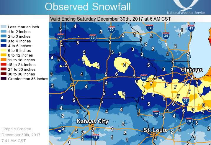
A winter storm brought light to moderate snow across much of eastern Iowa and northwest Illinois on Friday. Snow fell mainly north of a line from Fairfield, IA to Macomb, IL, with total accumulations ranging from around 2 to 7 inches. The highest amounts were located along the Interstate 80 corridor, with locations around Solon, IA recording up to 7.5 inches. National Weather Service Official Observations (event totals):
This page will be updated as needed as more information is obtained. |
|
Snow/Ice
 |
| Midwest Snowfall Analysis - Valid 6 AM December 30th, 2017 |
Storm Reports
| Interactive Map of Reports |
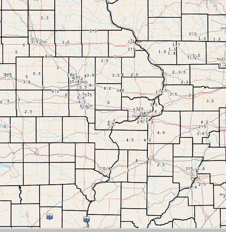 |
Public Information Statement
National Weather Service Quad Cities IA IL
622 AM CST Sat Dec 30 2017

...Snowfall Reports for December 29th, 2017...
Location                     Amount    Time/Date       Lat/Lon
1 NE Lake Macbride State Par 7.5 in    0808 PM 12/29   41.81N/91.53W
4 N Marengo                  7.0 in    0916 PM 12/29   41.85N/92.07W
Moline Quad-City Airport     6.7 in    1200 AM 12/30   41.45N/90.50W
Rapids City                  6.6 in    0638 PM 12/29   41.58N/90.34W
2 SSE Cedar Rapids           6.0 in    0731 PM 12/29   41.95N/91.66W
1 E Muscatine                6.0 in    1008 PM 12/29   41.42N/91.05W
1 W Amana                    6.0 in    0729 PM 12/29   41.80N/91.88W
3 NE Rochester               6.0 in    0933 PM 12/29   41.70N/91.13W
Palo                         5.9 in    0730 PM 12/29   42.06N/91.80W
1 WSW University Heights     5.9 in    0925 PM 12/29   41.65N/91.57W
1 NNW North Liberty          5.6 in    0804 PM 12/29   41.76N/91.62W
Solon                        5.5 in    0834 PM 12/29   41.80N/91.49W
2 WNW Cedar Rapids           5.4 in    0900 PM 12/29   41.98N/91.71W
Iowa City Municipality       5.3 in    0636 PM 12/29   41.63N/91.55W
1 SSW Hiawatha               5.0 in    0804 PM 12/29   42.03N/91.69W
4 NNE Fairfax                5.0 in    0657 PM 12/29   41.97N/91.75W
Cambridge                    4.9 in    0807 PM 12/29   41.30N/90.20W
1 E New Windsor              4.2 in    0738 PM 12/29   41.20N/90.44W
Stanwood                     4.2 in    0806 PM 12/29   41.89N/91.15W
2 WNW Dover                  4.2 in    0910 PM 12/29   41.44N/89.43W
Lowden                       4.0 in    0841 PM 12/29   41.86N/90.92W
1 WSW Bettendorf             4.0 in    0623 PM 12/29   41.56N/90.49W
Davenport Municipality       3.9 in    1203 AM 12/30   41.62N/90.58W
Springville                  3.8 in    0744 PM 12/29   42.06N/91.45W
Unionville                   3.5 in    0805 PM 12/29   41.81N/89.98W
Wyoming                      3.5 in    0623 PM 12/29   42.06N/91.00W
Maquoketa                    2.5 in    0729 PM 12/29   42.07N/90.67W
Milledgeville                2.2 in    0652 PM 12/29   41.97N/89.78W
Dubuque                      2.0 in    0802 PM 12/29   42.50N/90.69W
Mount Carroll                2.0 in    0821 PM 12/29   42.10N/89.98W
2 NW Woodbine                1.9 in    0830 PM 12/29   42.37N/90.18W
Clinton                      1.8 in    0800 PM 12/29   41.84N/90.23W
1 ENE Nora                   1.7 in    0831 PM 12/29   42.46N/89.93W
Stockton                     1.4 in    0755 PM 12/29   42.35N/90.01W

Observations are collected from a variety of sources with varying
equipment and exposures. We thank all volunteer weather observers
for their dedication. Not all data listed are considered official.
$$
 |
Media use of NWS Web News Stories is encouraged! Please acknowledge the NWS as the source of any news information accessed from this site. |


.png)