
Heat expands across the Desert Southwest, Plains, Mississippi Valley and Midwest into Monday. Fire weather concerns continue for portions of the Intermountain West. Active monsoonal moisture fuels thunderstorms over the Southwest with possible flash flooding. Tropical cyclone Fausto in the Pacific, should weaken as it approaches Hawaii; Dangerous surf, swells and rip currents are expected. Read More >
Overview
|
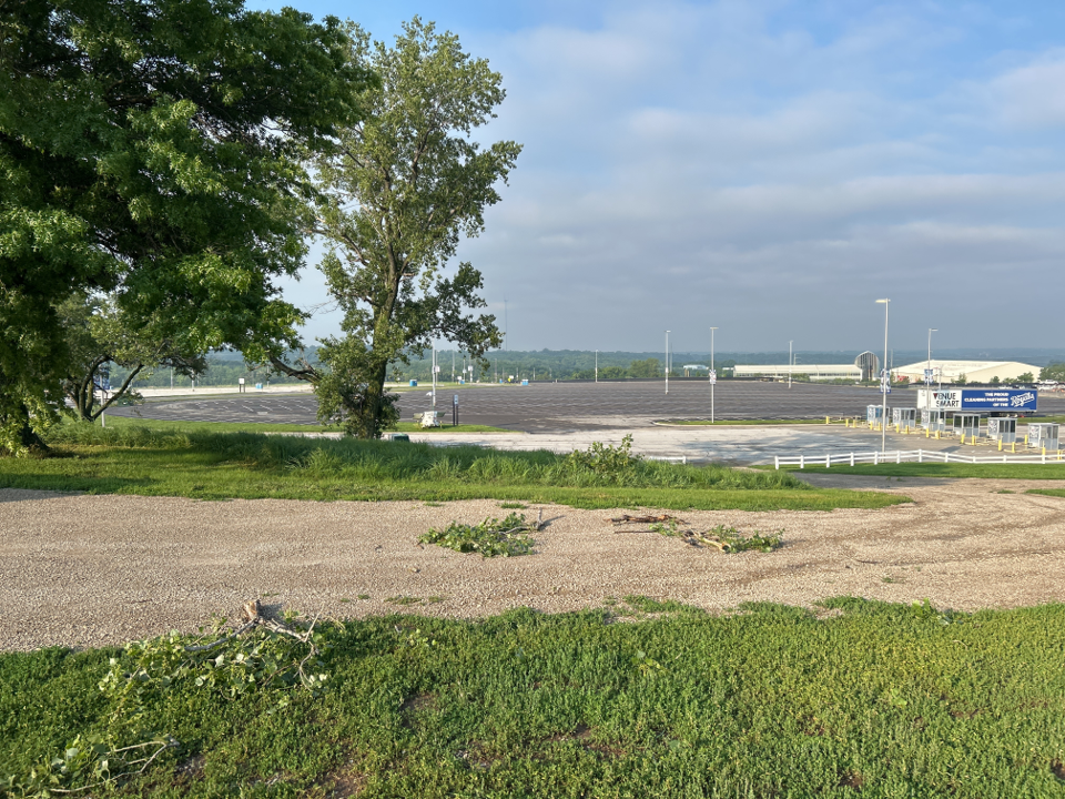
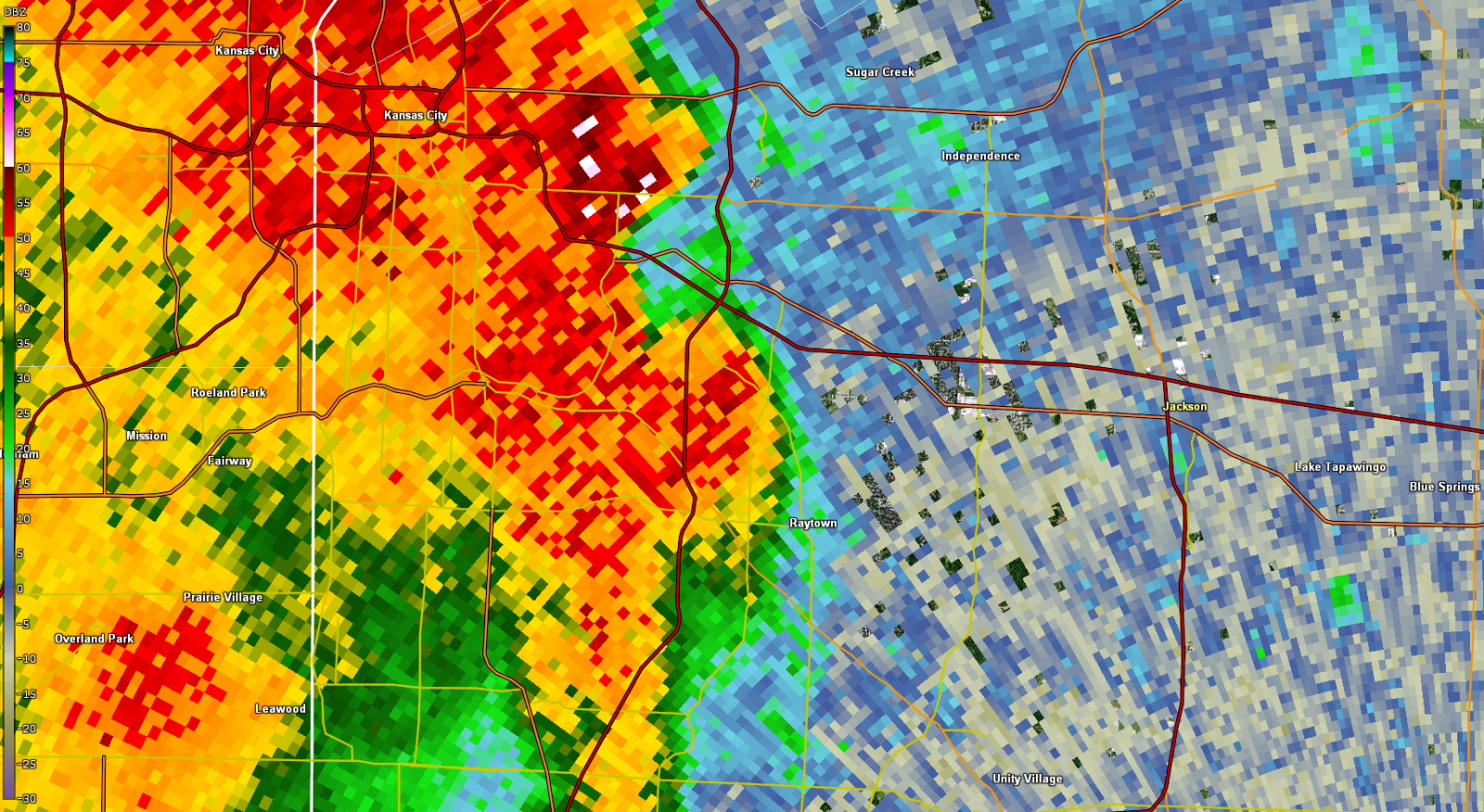
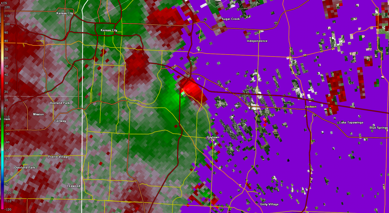
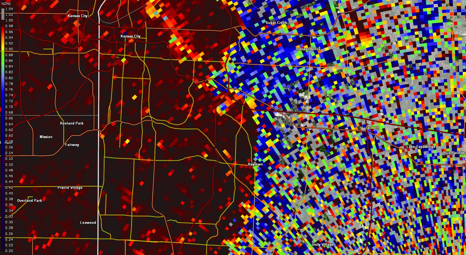
A line of thunderstorms produced a circulation that resulted in two tornadoes from eastern Kansas City, MO through Independence, MO. The first tornado is only confirmed via a radar debris signature for one radar scan, and video footage near the Interstate 435 / Interstate 70 interchange. Aside from several tree branches and twigs across a wide open parking lot, there are no damage items to assign a wind speed. Therefore, this tornado is rated EF-U. The second tornado through Independence, MO resulted in several healthy trees being snapped, resulting in damage consistent with an EF-1 tornado, with winds up to 100 MPH. Other damage points were noted south of the circulation, but are consistent with straight line winds. |
Tornadoes
Select a tornado from the table to zoom into the track and view more information. The default table view is limited to 8 tracks, but can be scrolled by a mouse wheel or dynamically expanded. Additionally, the table can fill the entire window by clicking the small circular expanding arrow icon at the very top right of the table and returned to its original size by clicking the button again. The side information panel that opens over the map can be closed using the "X" on the upper right corner of the pop-up. Zoom into the map and click damage points to see detailed information and pictures from the surveys.
|
NOTE: times shown below are local to your device's time zone. |

The Enhanced Fujita (EF) Scale classifies tornadoes into the following categories:
| EF0 Weak 65-85 mph |
EF1 Moderate 86-110 mph |
EF2 Significant 111-135 mph |
EF3 Severe 136-165 mph |
EF4 Extreme 166-200 mph |
EF5 Catastrophic 200+ mph |
 |
|||||
| Tornadoes that fail to impact any ratable damage indicators on the EF-Scale are rated EF-Unknown (EF-U) | |||||
Photos & Video
 |
 |
 |
 |
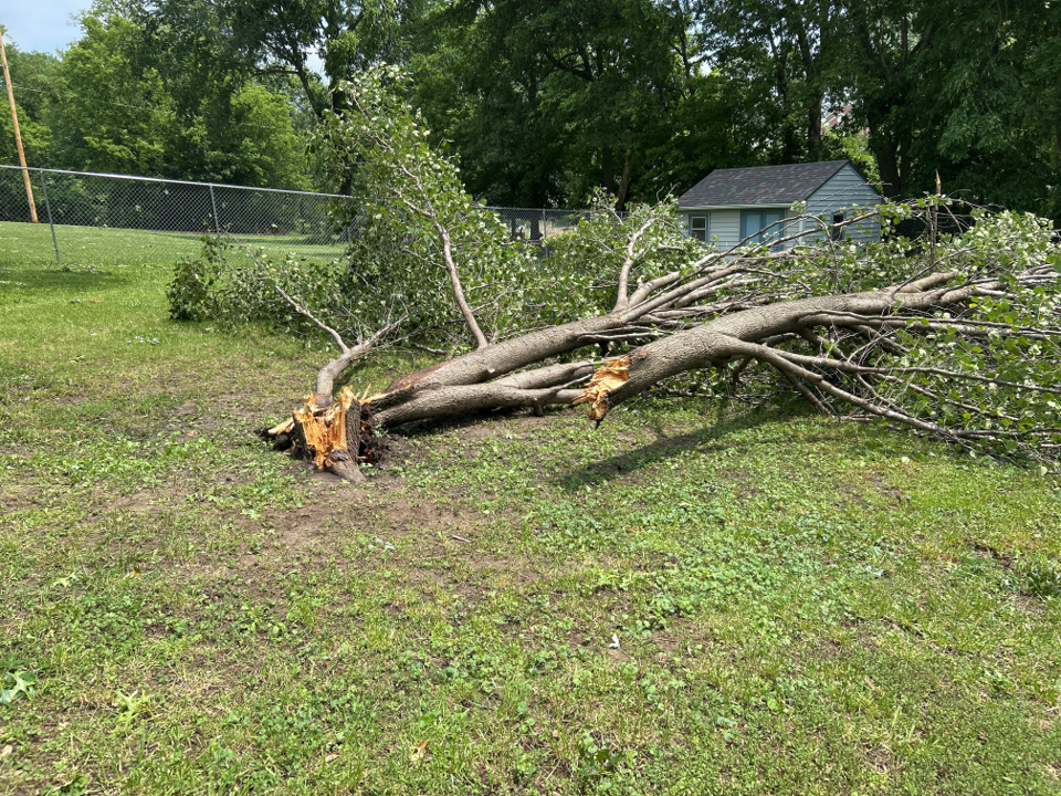
| Tree damage at the I-70 & I-435 (Source: NWS Storm Survey) |
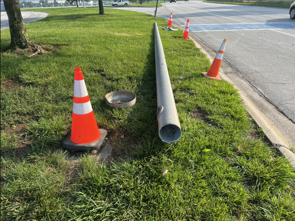
Light pole snapped in parking lot near I-70 & I-435 (Source: NWS Storm Survey) |
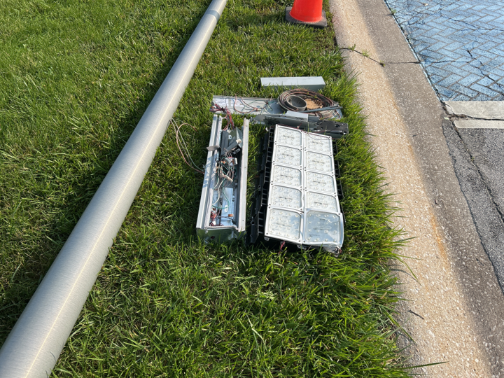
Electrical box damaed in parking lot near I-70 & I-435 (Source: NWS Storm Survey) |
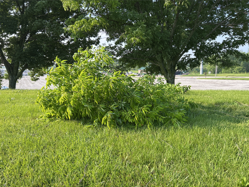
Tree Damage at the I-70 & I-435 (Source: NWS Storm Survey) |
 |
 |
 |
 |
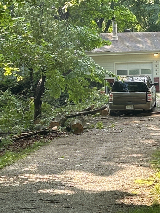
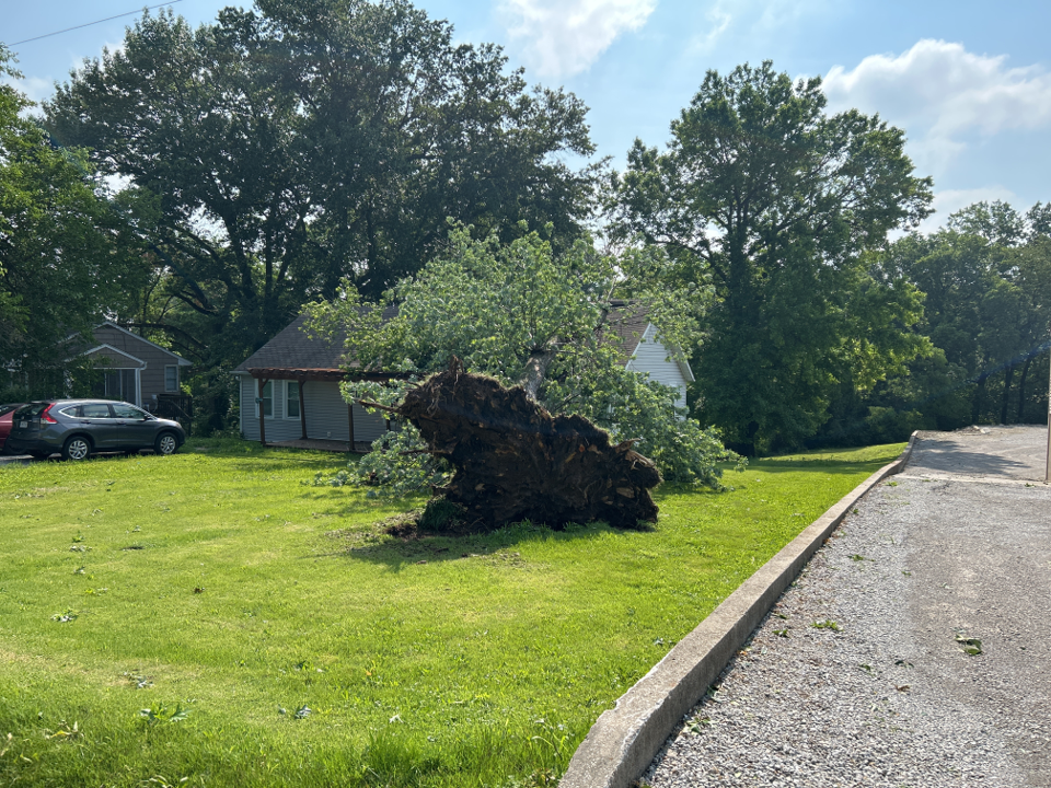
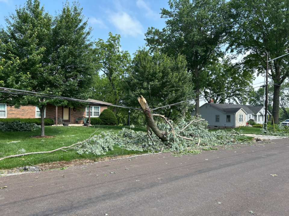
| Tree fallen on home and vehicle in Independence (Source: NWS Storm Survey) |
Tree uprooted in Independence (Source: NWS Storm Survey) |
Tree fallen on power lines in Independence (Source: NWS Storm Survey) |
Tree snapped and fallen in Independence (Source: NWS Storm Survey) |
Storm Reports
000
NWUS53 KEAX 042251
LSREAX
Preliminary Local Storm Report...Summary
National Weather Service Kansas City/Pleasant HIll MO
551 PM CDT Wed Jun 4 2025
..TIME... ...EVENT... ...CITY LOCATION... ...LAT.LON...
..DATE... ....MAG.... ..COUNTY LOCATION..ST.. ...SOURCE....
..REMARKS..
0142 PM Tstm Wnd Dmg 3 SW Edgerton 38.74N 95.06W
06/03/2025 Miami KS Public
Downed trees and wires east of Wellsville.
Time estimated from radar.
0145 PM Tstm Wnd Dmg 5 WSW Leavenworth 39.27N 95.01W
06/03/2025 Leavenworth KS Emergency Mngr
Downed tree at intersection of High Prairie
Road and 187th Street. Time estimated from
radar.
0145 PM Tstm Wnd Dmg 6 S Edgerton 38.67N 95.02W
06/03/2025 Miami KS Utility Company
Several reports of downed wires and tree
limbs near Hillsdale Recreation Area. Time
estimated from radar.
0149 PM Tstm Wnd Dmg 1 N Leavenworth 39.32N 94.92W
06/03/2025 Leavenworth KS Utility Company
Downed wires and power outages near 7th
Street. Time estimated from radar.
0202 PM Tstm Wnd Dmg Olathe 38.89N 94.81W
06/03/2025 Johnson KS Public
Social media photo of a large tree uprooted
in Olathe. Time estimated from radar.
0202 PM Tstm Wnd Dmg 1 SSE Lansing 39.23N 94.89W
06/03/2025 Leavenworth KS Utility Company
Downed wires and power outages near Gilman
Road. Time estimated from radar.
0205 PM Tstm Wnd Dmg 3 NW Wolcott 39.22N 94.84W
06/03/2025 Leavenworth KS Public
Downed tree on Tontine Road near Route 5.
Time estimated from radar.
0209 PM Tstm Wnd Dmg 2 ESE Platte City 39.36N 94.75W
06/03/2025 Platte MO Utility Company
Downed wires and power outages east of
Platte City. Time estimated from radar.
0209 PM Tstm Wnd Dmg 4 WSW Stanley 38.82N 94.73W
06/03/2025 Johnson KS Public
Several reports of downed tree limbs in the
Stanley and Heritage Park areas. Time
estimated from radar.
0212 PM Tstm Wnd Dmg 2 S Overland Park 38.95N 94.67W
06/03/2025 Johnson KS Utility Company
Downed tree limbs and wires near Foster
Street. Time estimated from radar.
0212 PM Tstm Wnd Dmg 2 S Overland Park 38.95N 94.67W
06/03/2025 Johnson KS Utility Company
Downed tree limbs and wires near Riley
Street. Time estimated from radar.
0212 PM Tstm Wnd Dmg 5 E Ferrelview 39.30N 94.58W
06/03/2025 Clay MO Utility Company
Downed tree limbs and wires near Walnut
Street. Time estimated from radar.
0212 PM Tstm Wnd Dmg 2 NW Muncie 39.11N 94.77W
06/03/2025 Wyandotte KS Utility Company
Downed tree and wires near 82nd Street. Time
estimated from radar.
0212 PM Tstm Wnd Dmg 2 NW Muncie 39.11N 94.77W
06/03/2025 Wyandotte KS Utility Company
Downed tree and wires near Elizabeth Avenue.
Time estimated from radar.
0212 PM Tstm Wnd Dmg 1 NE Overland Park 38.99N 94.66W
06/03/2025 Johnson KS Public
Social media video of a tree down at a
residence in Overland Park. Time estimated
from radar.
0216 PM Tstm Wnd Dmg 2 SSE Beverly Hills 39.13N 94.71W
06/03/2025 Wyandotte KS Utility Company
Downed wires near Greeley Avenue. Time
estimated from radar.
0216 PM Tstm Wnd Dmg 2 SSE Beverly Hills 39.13N 94.72W
06/03/2025 Wyandotte KS Utility Company
Downed tree and wires near Cleveland Avenue.
Time estimated from radar.
0216 PM Tstm Wnd Dmg 3 WNW Kansas City Kansa 39.13N 94.68W
06/03/2025 Wyandotte KS Dept of Highways
Semi blown over on I-635 near Parallel
Parkway. Time estimated from radar.
0216 PM Tstm Wnd Dmg 1 E Prairie Village 38.99N 94.61W
06/03/2025 Johnson KS Public
Downed wires and power outages reported
north of Leawood. Time estimated from radar.
0219 PM Tstm Wnd Dmg Fairway 39.02N 94.63W
06/03/2025 Johnson KS Utility Company
Downed tree limbs and wires near 62nd
Terrace. Time estimated from radar.
0219 PM Tstm Wnd Dmg 1 SW Kansas City Kansas 39.10N 94.65W
06/03/2025 Wyandotte KS Utility Company
Downed tree and wires near 17th Street. Time
estimated from radar.
0219 PM Tstm Wnd Dmg 1 NNE Westwood 39.05N 94.61W
06/03/2025 Wyandotte KS Public
Downed tree onto a building near the KU
Medical Center. Social media report and
photo. Time estimated from radar.
0219 PM Tstm Wnd Dmg 7 W Raytown 39.00N 94.59W
06/03/2025 Jackson MO Utility Company
Downed tree and wires near 70th Street. Time
estimated from radar.
0223 PM Tstm Wnd Dmg 1 N Houston Lake 39.21N 94.62W
06/03/2025 Platte MO Utility Company
Downed wires near Robinhood Lane. Time
estimated from radar.
0223 PM Tstm Wnd Dmg 3 SSE Kansas City 39.05N 94.56W
06/03/2025 Jackson MO Utility Company
Downed tree and wires near Quincy Avenue.
Time estimated from radar.
0223 PM Tstm Wnd Dmg 1 S Lake Waukomis 39.21N 94.64W
06/03/2025 Platte MO Utility Company
Downed tree limbs and wires near 66th
Street. Time estimated from radar.
0225 PM Tornado 3 NNW Raytown 39.05N 94.49W
06/03/2025 Jackson MO NWS Storm Survey
Confirmed tornado via radar and video
footage.
0226 PM Tstm Wnd Dmg 2 N Raytown 39.04N 94.46W
06/03/2025 Jackson MO Broadcast Media
Downed tree onto a vehicle near 47th and
Maywood. Time estimated from radar.
0226 PM Tstm Wnd Dmg 3 NNW Raytown 39.05N 94.50W
06/03/2025 Jackson MO Dept of Highways
Semi blown over near I-435 and Raytown Road.
Multiple trees down east of this location.
Time estimated from radar.
0226 PM Tstm Wnd Dmg 4 W Stanley 38.85N 94.74W
06/03/2025 Johnson KS Emergency Mngr
Downed power lines near 151st and Pflumm.
Time estimated from radar.
0227 PM Flash Flood Easton 39.34N 95.11W
06/03/2025 Leavenworth KS Emergency Mngr
Dawson Creek inundating roads in the Easton
area. Time estimated from radar.
0227 PM Tstm Wnd Dmg 2 NW Raytown 39.04N 94.49W
06/03/2025 Jackson MO Utility Company
Multiple reports of tree limbs and wires
down in the Raytown area. Time estimated
from radar.
0230 PM Tstm Wnd Dmg 2 NNW Chiles 38.71N 94.78W
06/03/2025 Miami KS Utility Company
Downed tree limbs and wires near Renner
Road. Time estimated from radar.
0230 PM Tstm Wnd Dmg 1 NE Gladstone 39.22N 94.54W
06/03/2025 Clay MO Utility Company
Downed wires near Askew Avenue. Time
estimated from radar.
0230 PM Tstm Wnd Dmg 1 ESE Independence 39.09N 94.39W
06/03/2025 Jackson MO Public
Several downed or snapped trees near Lees
Summit Road. Time estimated from radar.
0230 PM Tstm Wnd Dmg 1 SE Raytown 39.00N 94.45W
06/03/2025 Jackson MO Public
Downed wires and power outages near Crisp
Avenue. Time estimated from radar.
0230 PM Flash Flood Olathe 38.89N 94.81W
06/03/2025 Johnson KS Public
Multiple reports of street flooding in
Olathe. Time estimated from radar.
0230 PM Flash Flood 3 SW Kansas City Kansas 39.08N 94.67W
06/03/2025 Wyandotte KS Public
Report from mPING: Street/road flooding;
Street/road closed; Vehicles stranded.
0230 PM Tstm Wnd Dmg 3 S Maywood 39.06N 94.45W
06/03/2025 Jackson MO Public
Multiple reports of downed trees between
Independence and Raytown. Time estimated
from radar.
0230 PM Tstm Wnd Dmg 2 SSW Independence 39.06N 94.43W
06/03/2025 Jackson MO Emergency Mngr
EM relayed images of large tree snapped/down
just NE of intersection of 35th and Crysler.
Time estimated from radar.
0234 PM Tstm Wnd Gst 2 NNW Smithville 39.41N 94.59W
06/03/2025 M68 MPH Clay MO Public
Private weather sensor.
0235 PM Tstm Wnd Dmg 2 E Independence 39.09N 94.38W
06/03/2025 Jackson MO Emergency Mngr
EM relayed images of multiple trees snapped,
downed over roadway, or on homes. Time
estimated from radar.
0237 PM Tornado 2 E Independence 39.09N 94.37W
06/03/2025 Jackson MO NWS Storm Survey
Storm survey team has noted damage
consistent with a tornado. More information
to come.
0239 PM Flash Flood 1 NE Lansing 39.26N 94.88W
06/03/2025 Leavenworth KS Emergency Mngr
Route 5 closed from flooding of Nine Mile
Creek. Time based on dispatch report.
0240 PM Tstm Wnd Dmg 3 SE Courtney 39.13N 94.36W
06/03/2025 Jackson MO Public
Downed tree onto a boat at a residence near
Jackson Drive. Time estimated from radar.
0240 PM Tstm Wnd Dmg 3 SSE Liberty 39.21N 94.40W
06/03/2025 Clay MO Utility Company
Downed wires near Current Street. Time
estimated from radar.
0240 PM Tstm Wnd Dmg 4 E Independence 39.09N 94.35W
06/03/2025 Jackson MO Public
Social media report and photo of downed tree
damaging a vehicle near Alexander Road. Time
estimated from radar.
0240 PM Tstm Wnd Dmg 4 SE Courtney 39.11N 94.35W
06/03/2025 Jackson MO Public
Social media photos and reports of trees
down on Jones Road. Time estimated from
radar.
0240 PM Tstm Wnd Dmg 2 E Independence 39.09N 94.37W
06/03/2025 Jackson MO Public
Several downed trees near Truman Road east
of Route 291. Time estimated from radar.
0244 PM Tstm Wnd Dmg 2 W Missouri City 39.24N 94.33W
06/03/2025 Clay MO Utility Company
Downed tree limbs and wires near Missouri
City Road. Time estimated from radar.
0245 PM Tstm Wnd Dmg 5 WSW Buckner 39.12N 94.28W
06/03/2025 Jackson MO Public
Relayed report of severe large tree limbs
down across Highway 7. Time estimated from
radar.
0247 PM Tstm Wnd Dmg 2 WSW Missouri City 39.23N 94.33W
06/03/2025 Clay MO Utility Company
Downed wires near Scott Avenue. Time
estimated from radar.
0247 PM Tstm Wnd Dmg 5 WSW Buckner 39.12N 94.29W
06/03/2025 Jackson MO Public
Social media report of downed power lines
and bent over power poles near Indian Trails
Elementary. Time estimated from radar.
0251 PM Tstm Wnd Dmg 3 WNW Unity Village 38.96N 94.45W
06/03/2025 Jackson MO Utility Company
Downed wires and power outages near Military
Club Road. Time estimated from radar.
0254 PM Tstm Wnd Dmg 1 NNW Excelsior Springs 39.35N 94.23W
06/03/2025 Clay MO Utility Company
Downed tree and wires near Ley Street. Time
estimated from radar.
0255 PM Tstm Wnd Dmg Buckner 39.13N 94.20W
06/03/2025 Jackson MO Utility Company
Downed wires and power outages near Central
Street. Time estimated from radar.
0257 PM Tstm Wnd Dmg 5 SSE Stillwell 38.71N 94.63W
06/03/2025 Miami KS Utility Company
Downed tree limbs and wires near Mohawk
Street. Time estimated from radar.
0259 PM Tstm Wnd Dmg 5 SW Belton 38.76N 94.59W
06/03/2025 Cass MO Utility Company
Downed wires and power outages near 203rd
Street. Time estimated from radar.
0259 PM Tstm Wnd Dmg 3 N Lake Tapawingo 39.06N 94.31W
06/03/2025 Jackson MO Public
Several reports of downed trees north of
Lake Tapawingo. Time estimated from radar.
0300 PM Flash Flood Plattsburg 39.56N 94.46W
06/03/2025 Clinton MO Public
Multiple reports of street flooding in
Plattsburg. Time estimated from social media
posts.
0306 PM Tstm Wnd Dmg 4 N Fleming 39.26N 94.06W
06/03/2025 Ray MO Utility Company
Downed wires and power outages near Route
EE. Time estimated from radar.
0310 PM Flash Flood 1 N Grandview 38.91N 94.53W
06/03/2025 Jackson MO Public
Report from mPING: Street/road flooding;
Street/road closed; Vehicles stranded.
0315 PM Flash Flood 2 SSW Raytown 38.98N 94.49W
06/03/2025 Jackson MO Public
Social media photo of street flooding near
79th and Blue Ridge. Time estimated from
radar.
0316 PM Tstm Wnd Dmg Utica 39.75N 93.63W
06/03/2025 Livingston MO Public
Social media report of downed tree limbs
near Utica. Time estimated from radar.
0320 PM Tstm Wnd Gst 2 SW Mount Leonard 39.10N 93.42W
06/03/2025 M68 MPH Saline MO Public
Private weather sensor.
0323 PM Tstm Wnd Dmg 1 ENE Pleasant Hill 38.79N 94.25W
06/03/2025 Cass MO Utility Company
Downed tree and wires near Merle Road. Time
estimated from radar.
0327 PM Tstm Wnd Dmg 1 E Lexington 39.18N 93.85W
06/03/2025 Lafayette MO Public
mPING report of downed tree limbs in the
Lexington area. Time confirmed from radar.
0328 PM Tstm Wnd Dmg 2 NNE Emma 39.00N 93.48W
06/03/2025 Saline MO Public
Side and door of machine shed blown off,
power pole snapped, and multiple large limbs
down. Time estimated from radar.
0342 PM Tstm Wnd Dmg Norborne 39.30N 93.68W
06/03/2025 Carroll MO Utility Company
Downed wires and power outages reported in
the Norborne area. Time estimated from
radar.
0344 PM Tstm Wnd Dmg 5 W Dover 39.18N 93.78W
06/03/2025 Lafayette MO Public
Downed tree limbs near U.S. Highway 24 east
of Lexington. Time estimated from radar.
0350 PM Tstm Wnd Dmg 5 W Dover 39.18N 93.78W
06/03/2025 Lafayette MO Public
Large tree uprooted and split. Cornfield
debris strewn across property. Heavy fire
pit lifted and moved 10 feet. Metal framing
twisted and bent. Metal chairs lifted and
moved. Time estimated from radar.
0352 PM Tstm Wnd Dmg 4 SSE Reger 40.09N 93.16W
06/03/2025 Sullivan MO Emergency Mngr
Several downed trees...some up to 4 feet in
diameter...reported north to northeast of
Browning. Time estimated from radar.
0353 PM Tstm Wnd Dmg Marshall 39.12N 93.20W
06/03/2025 Saline MO Public
Social media reports and photos of trees
down in Marshall. Time estimated from radar.
0357 PM Tstm Wnd Dmg Slater 39.22N 93.06W
06/03/2025 Saline MO Law Enforcement
Tree damage and power lines down.
0403 PM Tstm Wnd Dmg 6 SSE Dalton 39.32N 92.96W
06/03/2025 Chariton MO Utility Company
Downed wires and power outages near Cazzell.
Time estimated from radar.
0406 PM Tstm Wnd Dmg Slater 39.22N 93.06W
06/03/2025 Saline MO Public
Social media photos of downed trees in
Slater. Time estimated from radar.
0406 PM Tstm Wnd Dmg 5 ENE Marshall 39.14N 93.11W
06/03/2025 Saline MO Utility Company
Downed wires and power outages near County
Road 111. Time estimated from radar.
0408 PM Tstm Wnd Dmg 1 NE Slater 39.23N 93.05W
06/03/2025 Saline MO Public
mPING report of downed and uprooted trees on
the east side of Slater. Time estimated from
radar.
0410 PM Tstm Wnd Dmg Green Castle 40.26N 92.88W
06/03/2025 Sullivan MO Utility Company
Downed wires near Lincoln Street. Time
estimated from radar.
0410 PM Tstm Wnd Dmg 3 WNW Sedalia 38.72N 93.29W
06/03/2025 Pettis MO Public
Several reports of large trees down in
Sedalia, including one onto a vehicle on
U.S. Highway 50. Time estimated from radar.
0412 PM Tstm Wnd Dmg 5 NNE Keytesville 39.51N 92.90W
06/03/2025 Chariton MO Utility Company
Downed tree and wires near Prather Avenue.
Time estimated from radar.
0417 PM Tstm Wnd Dmg 3 N Sedalia 38.74N 93.23W
06/03/2025 Pettis MO Utility Company
Downed tree limbs and wires near Route H.
Time estimated from radar.
0417 PM Tstm Wnd Dmg Sedalia 38.70N 93.23W
06/03/2025 Pettis MO Public
Several reports of downed tree limbs and
power lines in Sedalia and surrounding
areas. Time estimated from radar.
0418 PM Tstm Wnd Dmg 2 SSW Sedalia Memorial 38.68N 93.19W
06/03/2025 Pettis MO Public
Several downed trees in the Southgate area.
Photos via social media. Time estimated from
radar.
0420 PM Tstm Wnd Gst Sedalia Memorial Arpt 38.71N 93.18W
06/03/2025 M62 MPH Pettis MO ASOS
0423 PM Tstm Wnd Dmg 1 N Slater 39.23N 93.07W
06/03/2025 Saline MO Public
Reports of downed trees in Slater. Time
confirmed from radar.
0424 PM Tstm Wnd Dmg 5 N Glasgow 39.30N 92.84W
06/03/2025 Chariton MO Utility Company
Downed tree limbs and wires near Route 5.
Time estimated from radar.
0425 PM Tstm Wnd Dmg Nelson 38.99N 93.03W
06/03/2025 Saline MO Public
Social media photo of downed trees in
Nelson. Time estimated from radar.
0428 PM Tstm Wnd Dmg Pilot Grove 38.87N 92.91W
06/03/2025 Cooper MO Emergency Mngr
Emergency Manager reports large trees down
in Pilot Grove.
0431 PM Tstm Wnd Dmg Blackwater 38.98N 92.99W
06/03/2025 Cooper MO Utility Company
Downed tree limbs and wires in the
Blackwater area. Time estimated from radar.
0431 PM Tstm Wnd Dmg Greentop 40.35N 92.56W
06/03/2025 Schuyler MO Utility Company
Downed wires reported in Greentop. Time
estimated from radar.
0432 PM Tstm Wnd Dmg 1 N Clifton Hill 39.45N 92.67W
06/03/2025 Randolph MO Emergency Mngr
Downed trees along Route 3 north of Clifton
Hill. Time estimated from radar.
0432 PM Tstm Wnd Dmg 1 NNE Glasgow 39.24N 92.84W
06/03/2025 Howard MO Utility Company
Downed wires and power outages in the
Glasgow area. Time estimated from radar.
0435 PM Tstm Wnd Dmg 5 SSE Elmer 39.89N 92.62W
06/03/2025 Macon MO Utility Company
Downed wires near Route 3. Time estimated
from radar.
0439 PM Tstm Wnd Dmg 1 S Franklin 39.00N 92.76W
06/03/2025 Howard MO Utility Company
Downed wires near County Road 345. Time
estimated from radar.
0442 PM Tstm Wnd Dmg 1 ESE La Plata 40.02N 92.48W
06/03/2025 Macon MO Public
Tree limbs downed in La Plata along US
Highway 63.
0445 PM Tstm Wnd Dmg 2 SW Boonville 38.95N 92.78W
06/03/2025 Cooper MO Utility Company
Downed tree and wires near Sportsman Road.
Time estimated from radar.
0445 PM Tstm Wnd Dmg 1 WSW Moberly 39.42N 92.45W
06/03/2025 Randolph MO Utility Company
Downed tree and wires near Logan Street.
Time based on dispatch report and confirmed
from radar.
0445 PM Tstm Wnd Dmg 3 S Boonville 38.92N 92.76W
06/03/2025 Cooper MO Utility Company
Downed wires and power outages near
Billingsville Road. Time estimated from
radar.
0447 PM Tstm Wnd Dmg 3 SW Jacksonville 39.56N 92.51W
06/03/2025 Randolph MO Public
mPING report of downed tree limbs near
Holiday Acres Lake. Time estimated from
radar.
0448 PM Tstm Wnd Dmg 3 S Fayette 39.10N 92.69W
06/03/2025 Howard MO Utility Company
Multiple broken power poles south of
Fayette. Time estimated from radar.
0448 PM Tstm Wnd Dmg 1 ENE Boonville 38.97N 92.74W
06/03/2025 Cooper MO Utility Company
Downed tree and wires near Sycamore Street.
Time estimated from radar.
0448 PM Tstm Wnd Dmg 1 N Boonville 38.97N 92.75W
06/03/2025 Cooper MO Public
Social media video of a downed tree at a
residence. Time estimated from radar.
0449 PM Tstm Wnd Dmg 1 S Macon 39.73N 92.47W
06/03/2025 Macon MO Public
Reports of downed tree limbs in the Macon
area. Time estimated from radar.
0450 PM Tstm Wnd Dmg 3 SSE Fayette 39.10N 92.66W
06/03/2025 Howard MO Public
Downed tree limbs and wires near Route 240.
Time estimated from radar.
0452 PM Tstm Wnd Dmg 3 SE Fayette 39.11N 92.65W
06/03/2025 Howard MO Utility Company
Several downed trees and wires near County
Road 419. Time estimated from radar.
0454 PM Tstm Wnd Dmg New Franklin 39.02N 92.74W
06/03/2025 Howard MO Utility Company
Downed tree and wires near Chancellor
Street. Time estimated from radar.
0456 PM Tstm Wnd Dmg 3 E New Franklin 39.02N 92.69W
06/03/2025 Howard MO Utility Company
Downed tree and wires near County Road 448.
Time estimated from radar.
0456 PM Tstm Wnd Dmg Moberly 39.42N 92.44W
06/03/2025 Randolph MO Utility Company
Downed wires near Reed Street. Time
estimated from radar.
0456 PM Tstm Wnd Dmg 7 NNW Wooldridge 39.00N 92.58W
06/03/2025 Howard MO Utility Company
Downed wires near County Road 433. Time
estimated from radar.
0456 PM Tstm Wnd Dmg 1 SSE Moberly 39.41N 92.43W
06/03/2025 Randolph MO Utility Company
Downed tree and wires near Halleck Street.
Time estimated from radar.
0500 PM Flash Flood 1 N Moberly 39.44N 92.43W
06/03/2025 Randolph MO Public
Several reports and social media photos of
widespread street flooding in the Moberly
area with temporarily stalled vehicles in
spots. Time based on social media reports.
0845 PM Rain 1 W Easton 39.35N 95.14W
06/03/2025 M4.00 Inch Leavenworth KS Emergency Mngr
0849 PM Rain 6 SSW Easton 39.26N 95.16W
06/03/2025 M3.70 Inch Leavenworth KS Public
storm total rainfall.
0850 PM Rain Leavenworth 39.31N 94.92W
06/03/2025 M2.73 Inch Leavenworth KS Emergency Mngr
storm total rainfall.
0851 PM Rain 1 SW Basehor 39.13N 94.96W
06/03/2025 M2.10 Inch Leavenworth KS Emergency Mngr
storm total rainfall.
0852 PM Rain Linwood 39.00N 95.04W
06/03/2025 M2.12 Inch Leavenworth KS Emergency Mngr
storm total rainfall.
0959 PM Flood 2 ENE Prairie Home 38.83N 92.56W
06/03/2025 Cooper MO Law Enforcement
Vehicle disabled in water across Splice
Creek Road in Cooper County.
Radar
Header
 |
 |
 |
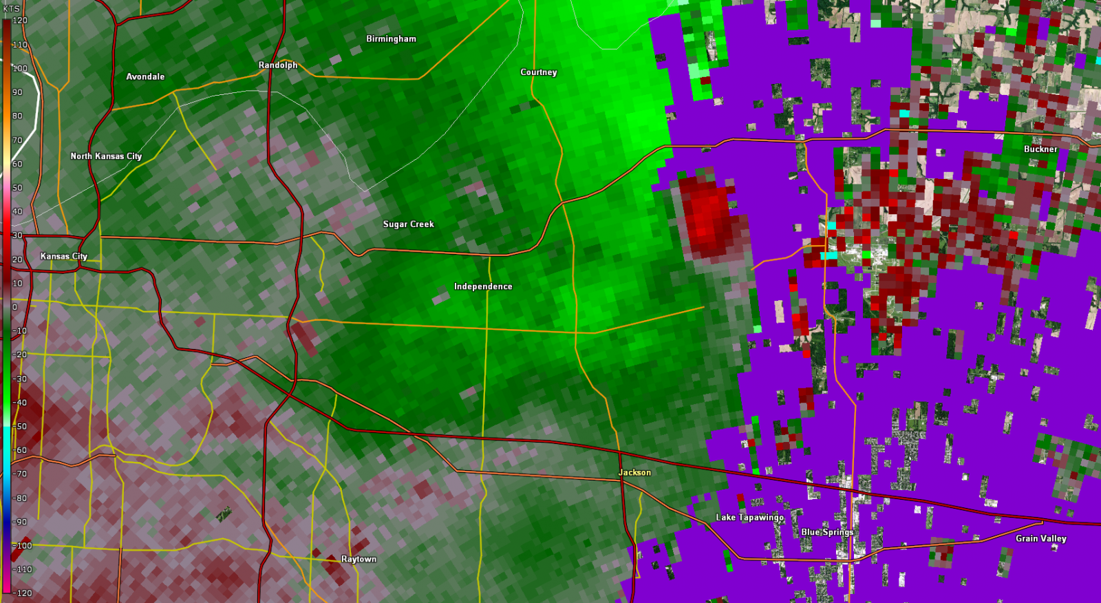 |
| Reflectivity Signature of tornado as it crossed I-435 & I-70 | Storm relative velocity of tornado as it crossed I-435 & I-70 | Elevated angle (0.8°) of correlation coefficient showing the tornadic debris signature. | Storm relative velocity of tornado as it moved through east Independence. |
 |
Media use of NWS Web News Stories is encouraged! Please acknowledge the NWS as the source of any news information accessed from this site. |
|


 Weather Story
 Weather Map
 Local Radar