
Isaias is expected to strengthen and be a strong hurricane when it approaches the northern Gulf Coast on Friday. Damaging hurricane-force winds and life-threatening storm surge impacts are expected Friday into Saturday. Isaias will bring heavy rainfall to the northern Gulf Coast and much of the Southeast U.S. Friday into the weekend. Read More >
Kansas City/Pleasant Hill, MO
Weather Forecast Office
Overview
|
A short wave trough lifted north across northeastern Kansas through the late afternoon and evening. Thunderstorms developed along the associated warm front, with isolated strong storms moving northeast across northeastern Kansas into northwestern Missouri. One storm resulted in a brief tornado in Atchison County Kansas, near Effingham, KS. More information via the Kansas City Star Article |
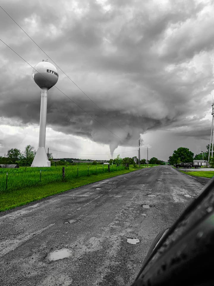 Photo Outside Effingham, KS via Twitter from @cjkc63 |
Tornadoes:
|
Tornado - LOCATION
Track Map 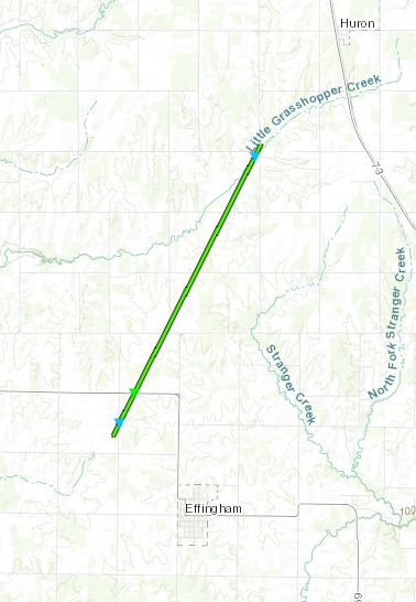  |
||||||||||||||||
The Enhanced Fujita (EF) Scale classifies tornadoes into the following categories:
| EF0 Weak 65-85 mph |
EF1 Moderate 86-110 mph |
EF2 Significant 111-135 mph |
EF3 Severe 136-165 mph |
EF4 Extreme 166-200 mph |
EF5 Catastrophic 200+ mph |
 |
|||||
 |
Media use of NWS Web News Stories is encouraged! Please acknowledge the NWS as the source of any news information accessed from this site. |
|
Hazards
Decision Support
Situation Report
Local Weather Story
Submit Report
Storm Prediction Center
Weather Prediction Center
National Hurricane Center
Active Alerts
National Radar
Current Weather
Local Radar
Local Precipitation/Temperature
National Radar
Satellite
Observations
Observed Precipitation
Water and Air
National Rivers
Local Rivers
Air Quality
Missouri Basin RFC
Forecasts
Decision Support
Weather Story
Forecast Discussion
Local Fire Weather
National Fire Weather
Aviation Weather
FAA Center Weather
Graphical Forecasts
Weather Prediction Center
Space Weather Center
Climate
Climate Prediction Center
KC Records and Normals
KC Holiday Climate
KC Seasonal Rankings
National Climate Services
Climate Data Center
Drought
Local Storm Reports

US Dept of Commerce
National Oceanic and Atmospheric Administration
National Weather Service
Kansas City/Pleasant Hill, MO
1803 North 7 Highway
Pleasant Hill, MO 64080-9421
816-540-6132 (6021 automated weather)
Comments? Questions? Please Contact Us.


 Weather Story
 Weather Map
 Local Radar
 Follow us on X
 Follow us on Facebook
 Follow us on YouTube
 EAX RSS Feed