
Flash flooding threatens areas from the Tennessee Valley to the Carolinas as storms repeat along a stalled front. Monsoonal storms may trigger flooding in the Southwest. Dangerous heat expands across the Desert Southwest, Plains, mid-Mississippi Valley and Southern Tier. Critical fire weather for interior Pacific Northwest. Cooler, drier air brings brief relief to the Great Lakes and Northeast. Read More >
Overview
|
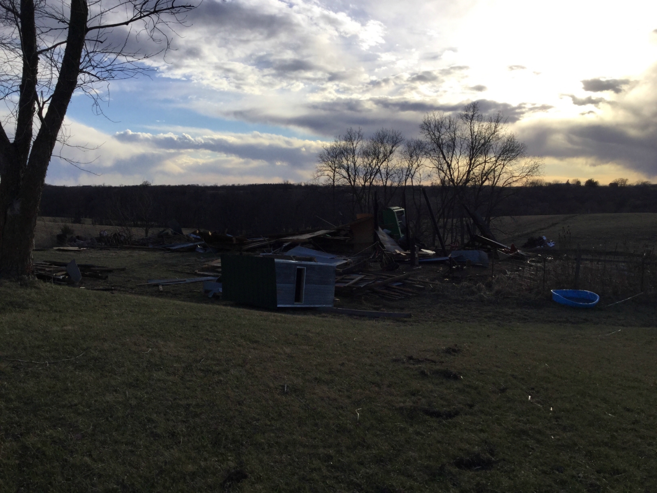
On March 6th, 2017, a line of severe thunderstorms developed ahead of a cold front, marching through eastern Kansas and across Missouri, causing multiple paths of damage. Ahead of this encroaching squall line, several supercells formed, which caused large hail up to the size of baseballs, along with several tornadoes. The most significant of these tornadoes was an EF-3 tornado, which hit Oak Grove, Missouri, and an EF-2 tornado that impacted the Smithville Lake area just north of Kansas City. Despite the widespread destruction from these tornadoes, there were no fatalities; however, there were about a dozen injured in the Oak Grove area. As the squall line proceeded eastward, it continued to produce widespread wind damage as well as several embedded tornadoes. By the end of the night, there would be at least a dozen tornadoes, mostly EF-0 and EF-1, and numerous reports of large hail and damaging winds. **NOTE: This webpage contains preliminary information and will be updated as surveys are completed and as additional information is made available.** |
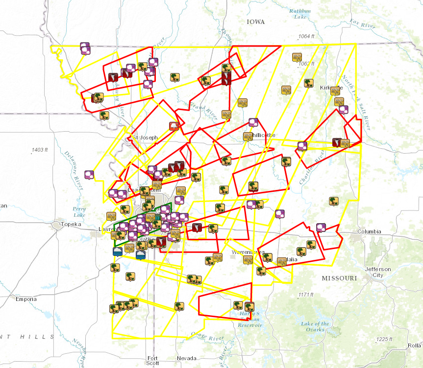 Warnings & LSRs Issued 6 March 2017 |
Tornadoes:
|
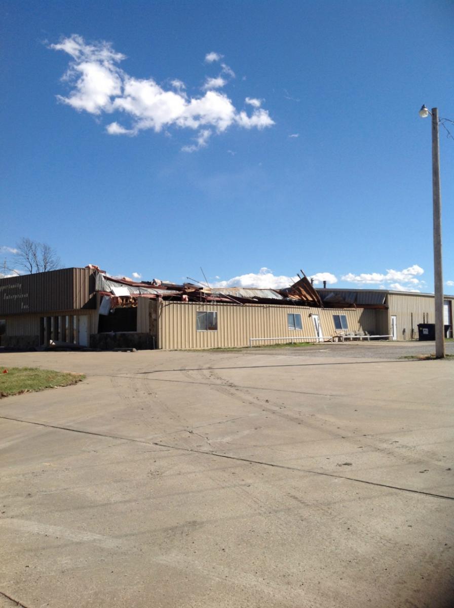
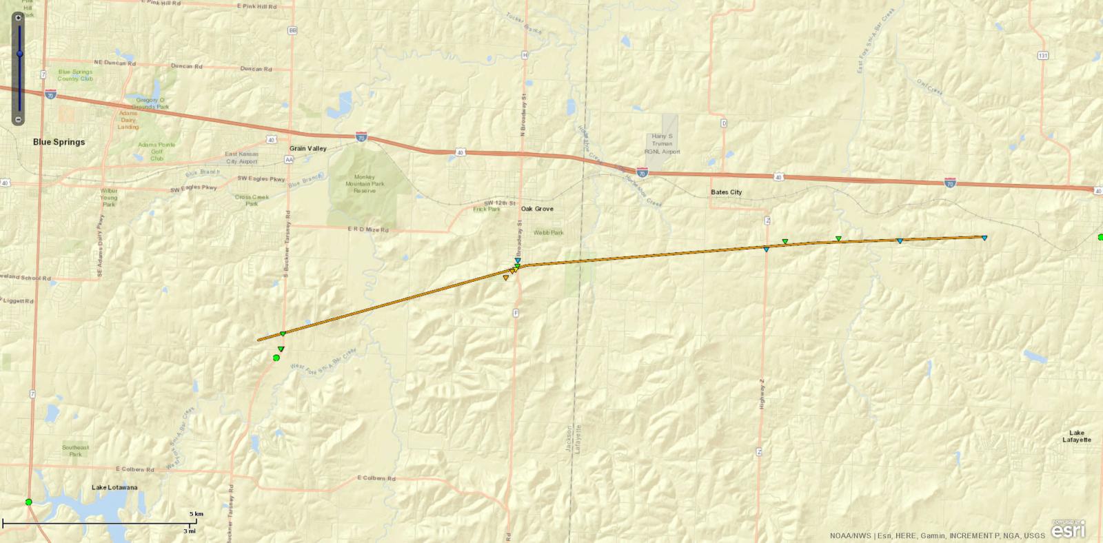
Tornado - Oak Grove
|
|
Tornado - Smithville to Lathrop
|
|
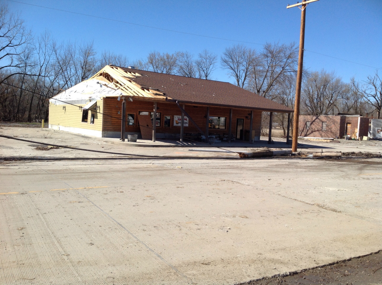
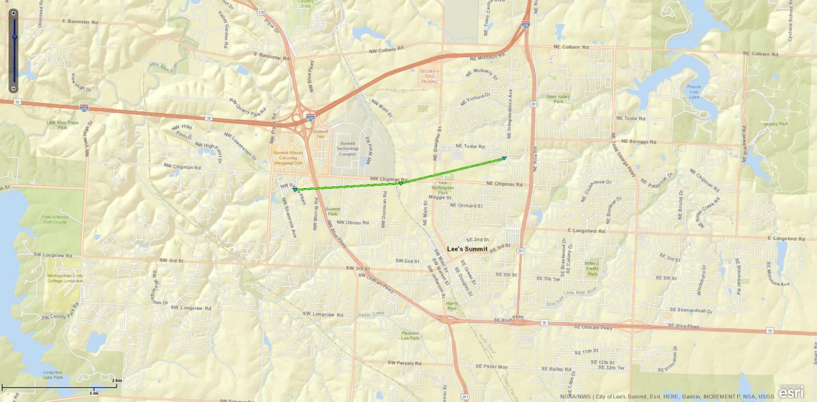
Tornado - Lee's Summit
|
|
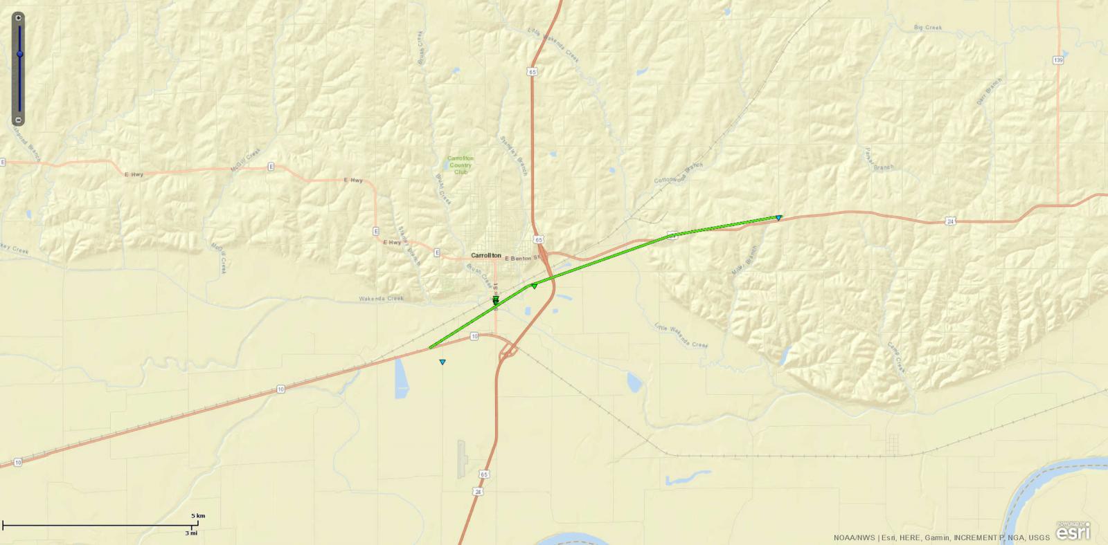
Tornado - Carrollton
|
|
Tornado - Leawood
Track Map 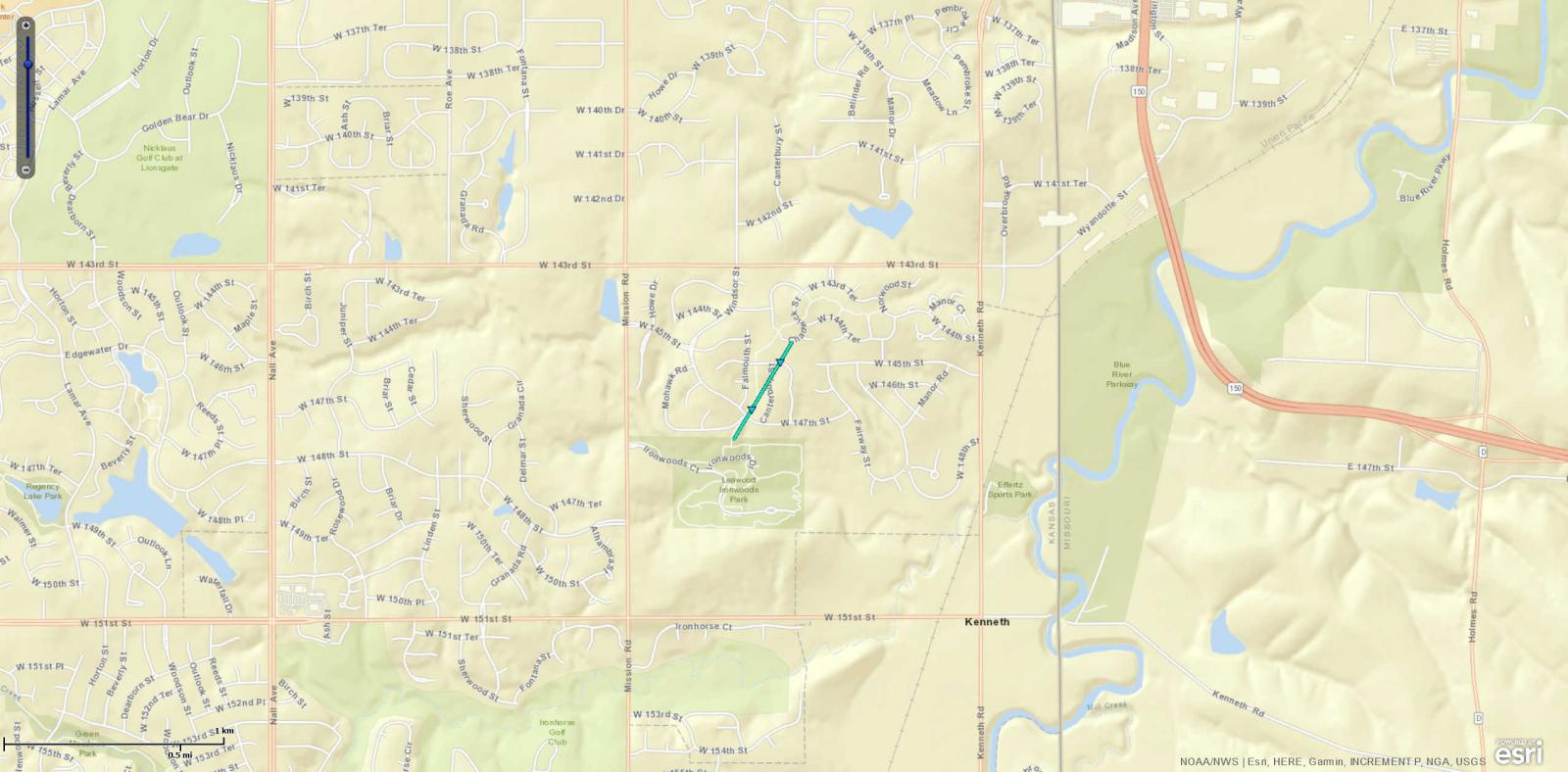 
|
|
Tornado - Mound City
Track Map 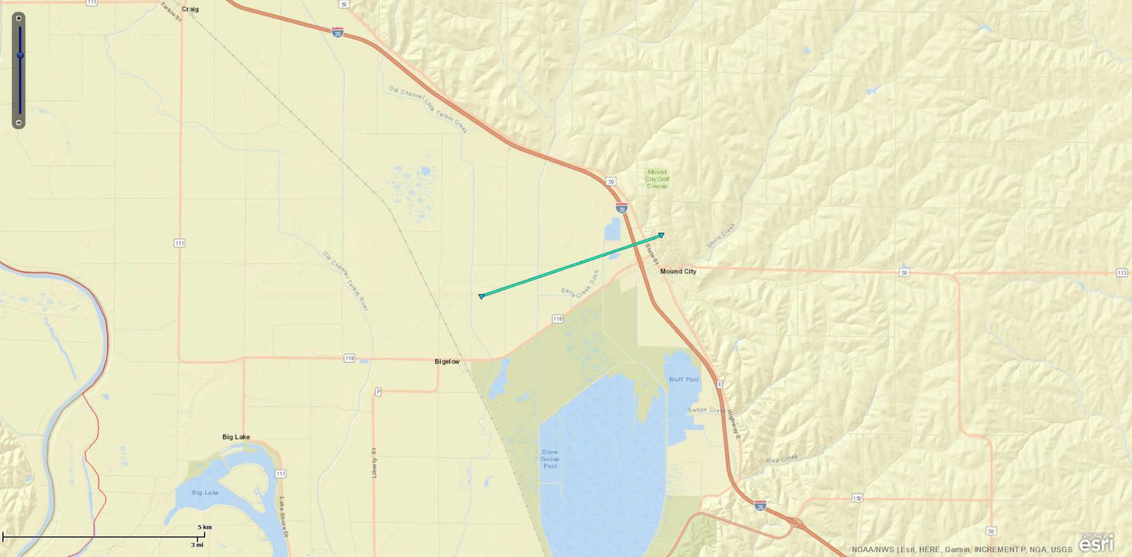
|
|
Tornado - Skidmore
Track Map 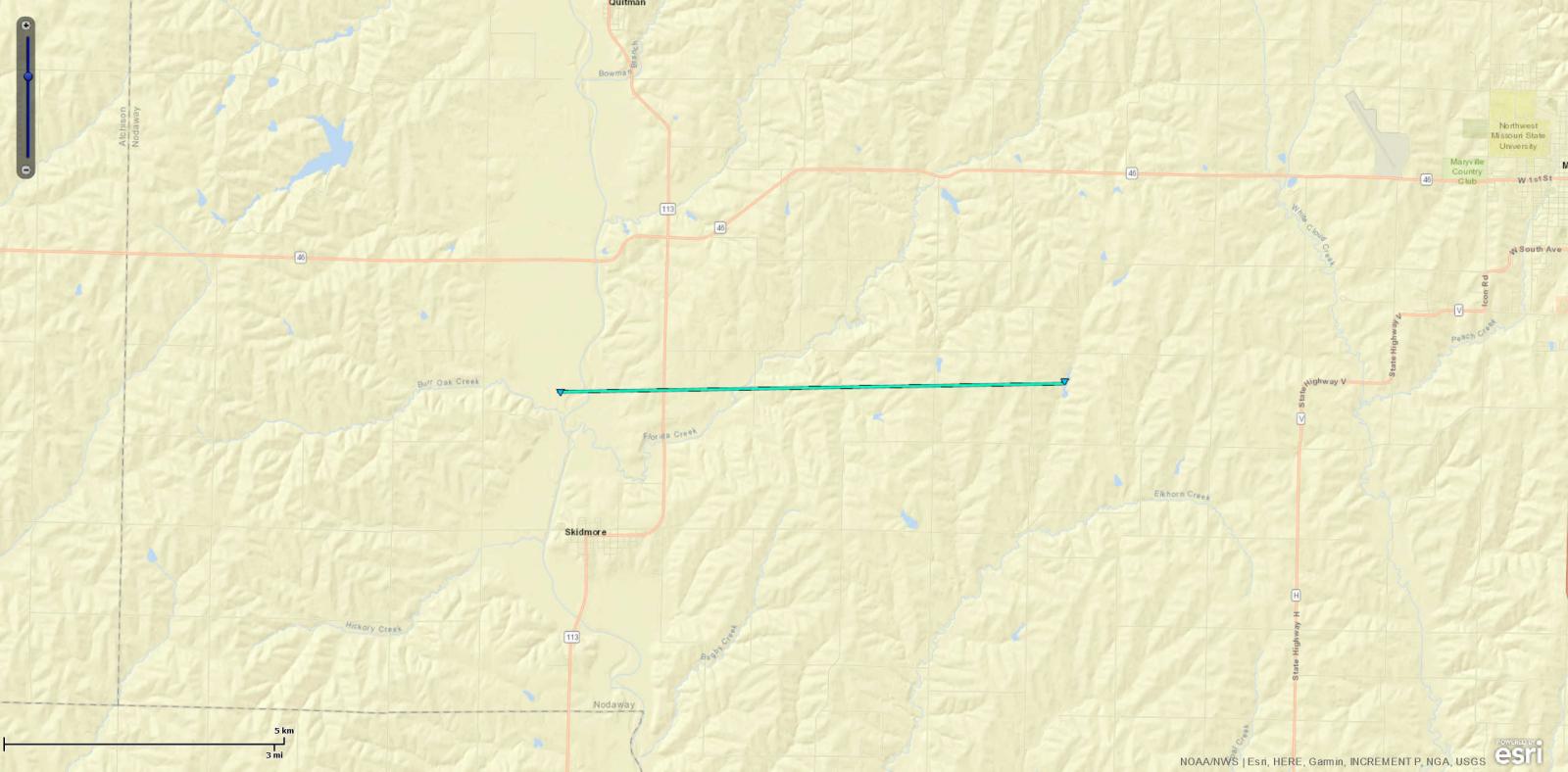
|
|
Tornado - Tightwad
Track Map 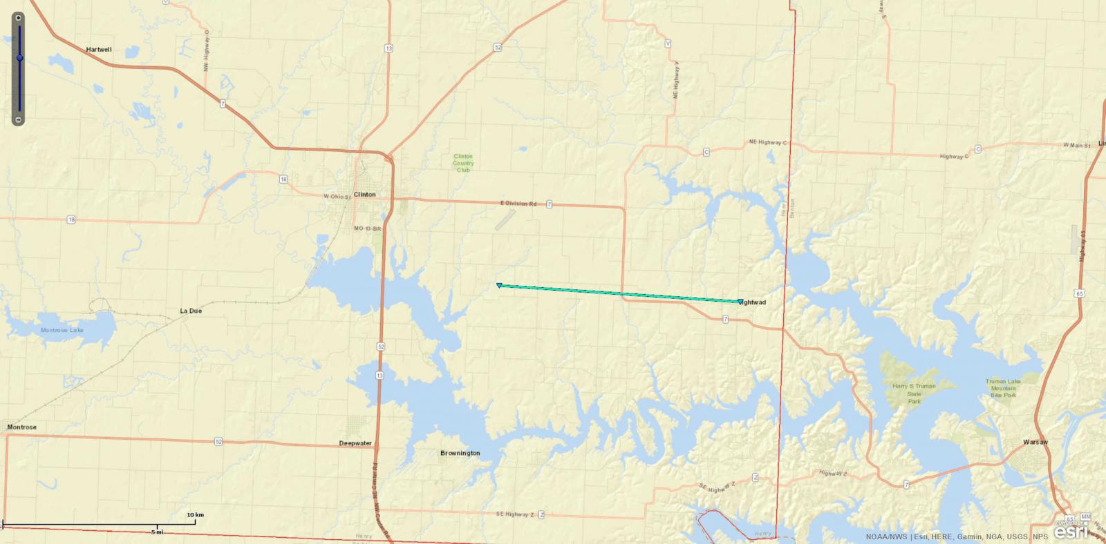
|
|
Tornado - Knob Noster
Track Map 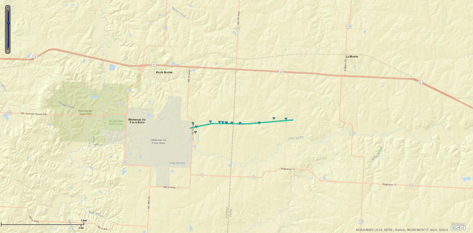
|
|
Tornado - Mercer County
Track Map 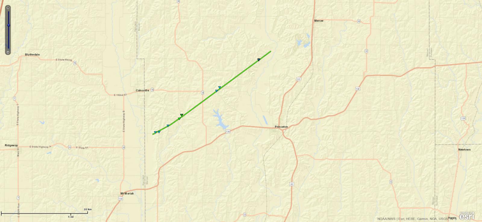
|
|
Tornado - Cooper County
Track Map 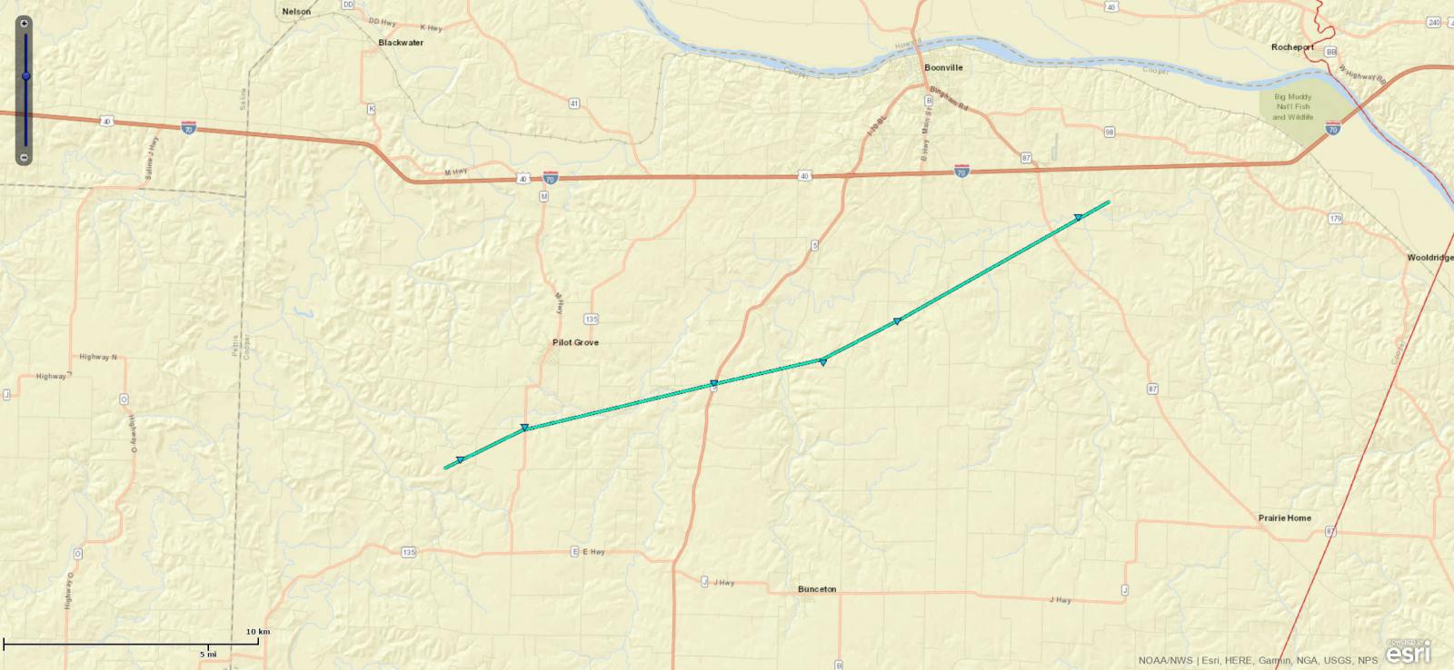
|
|
Tornado - Mayview
Track Map 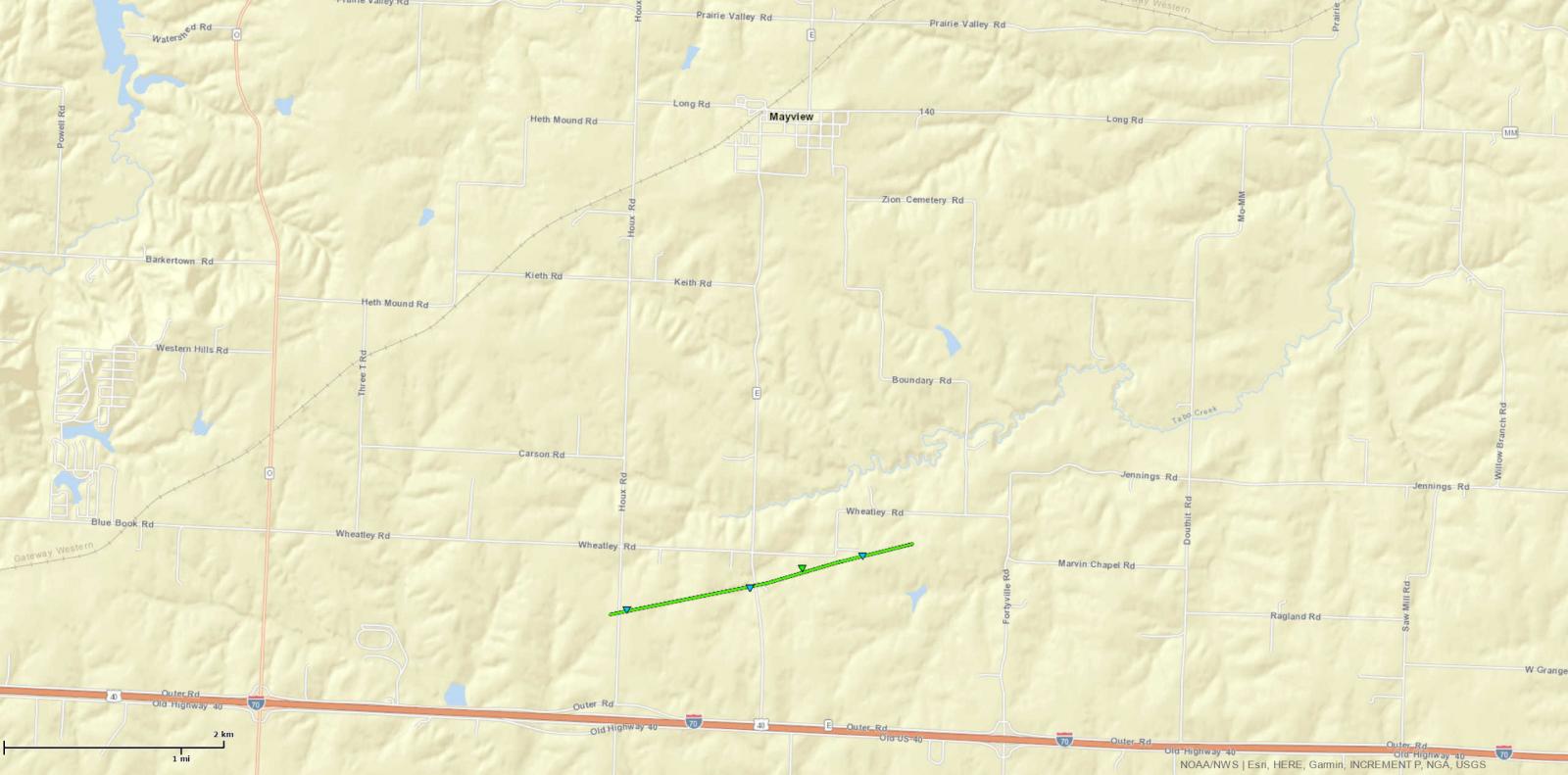
|
| EF0 Weak 65-85 mph |
EF1 Moderate 86-110 mph |
EF2 Significant 111-135 mph |
EF3 Severe 136-165 mph |
EF4 Extreme 166-200 mph |
EF5 Catastrophic 200+ mph |
 |
|||||
Wind & Hail:
More information will be added here as it becomes available.
Wind
Nearly 100 wind reports were collected, with the highest wind gust measured at 68 mph (59 knots) at the Mosby Midwest National Air Center Airport in Clay County, Missouri.
Hail
Over 50 hail reports were collected, 3 of which were baseball size hail, reported in Clay and Platte counties in Missouri, and Johnson County in Kansas.
Photos & Video:
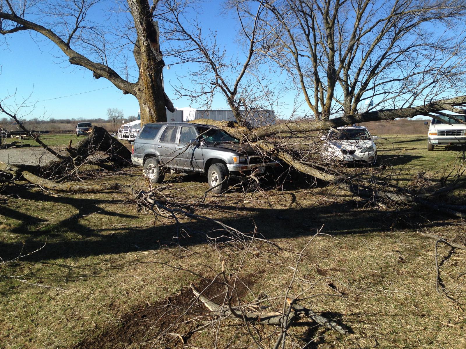
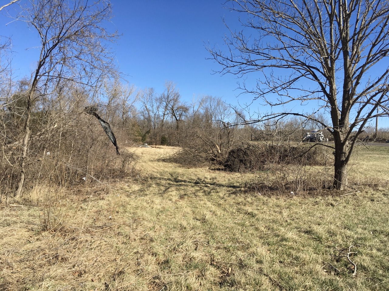
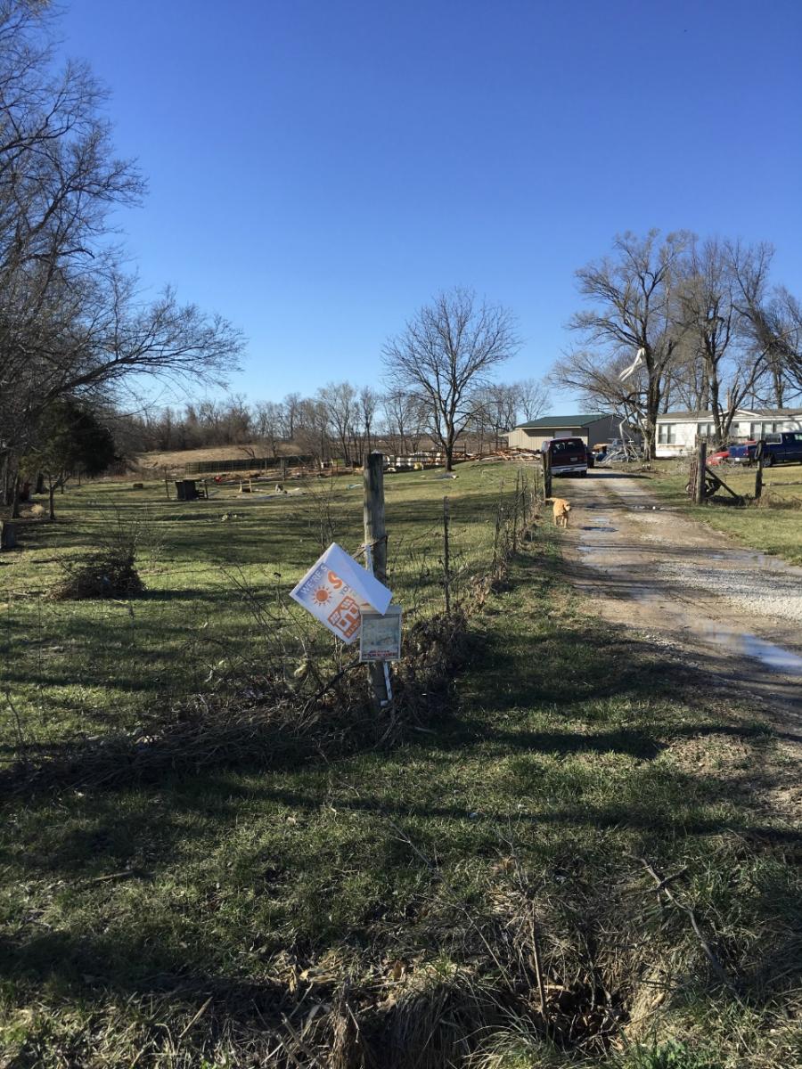
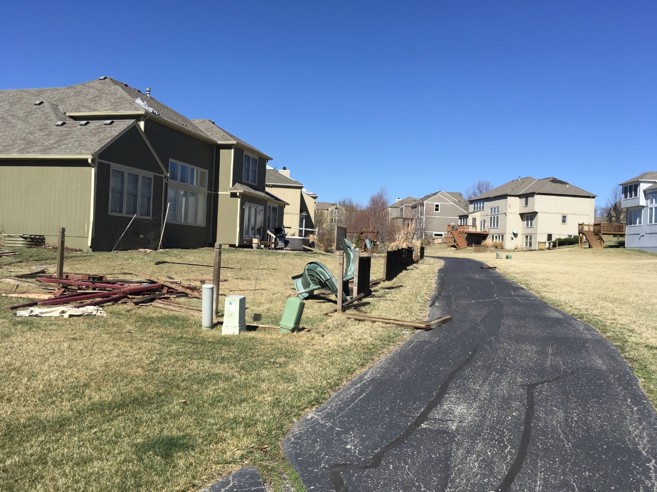
Smithville to Lathrop
 |
 |
 |
 |
| Smithville Survey (NWS Pleasant Hill) |
Smithville Survey (NWS Pleasant Hill) |
Smithville Survey (NWS Pleasant Hill) |
Smithville Survey (NWS Pleasant Hill) |
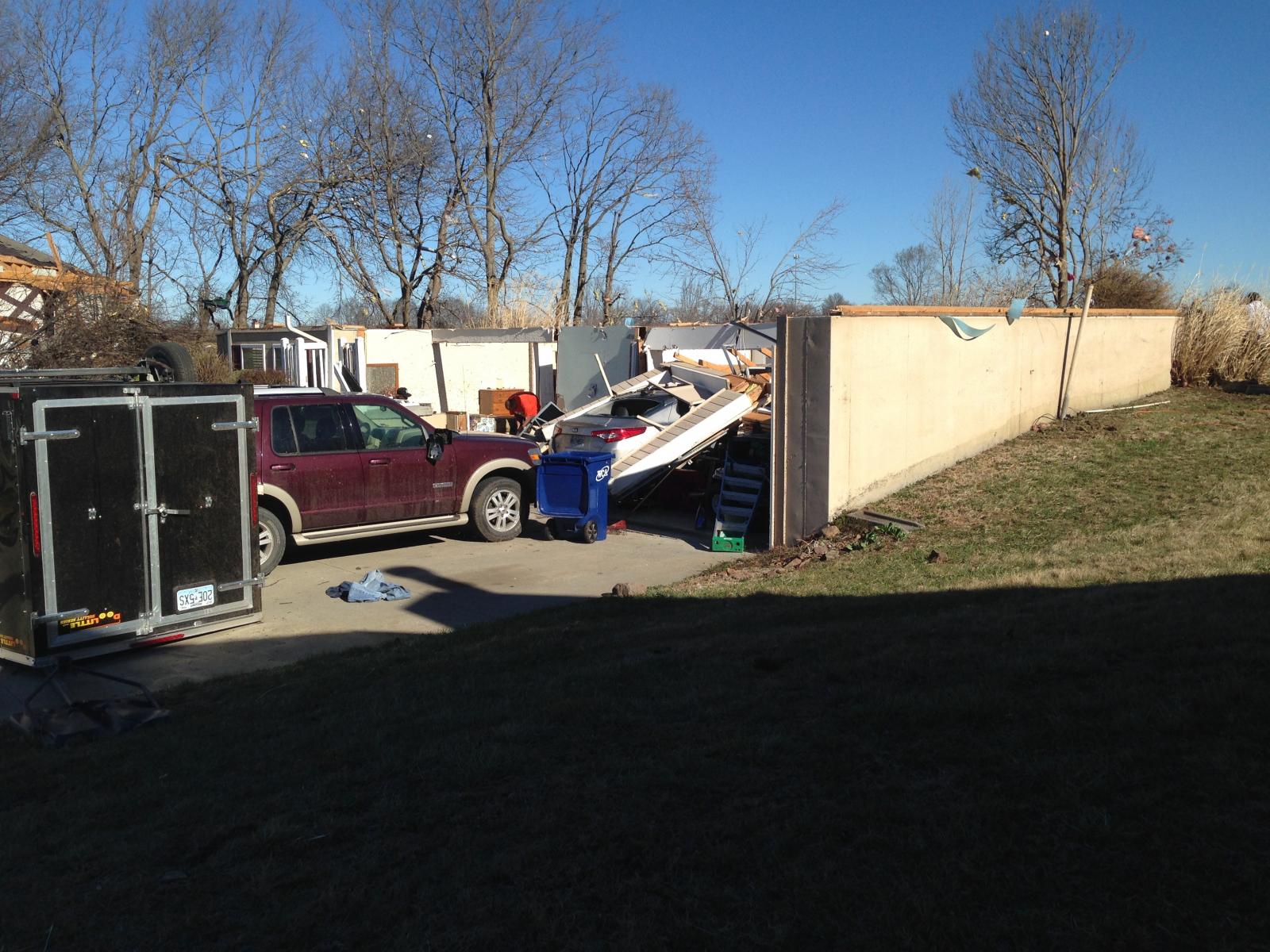
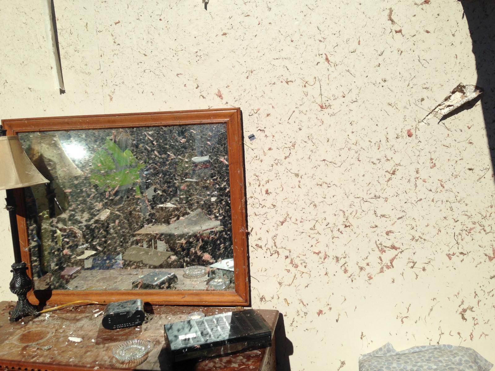
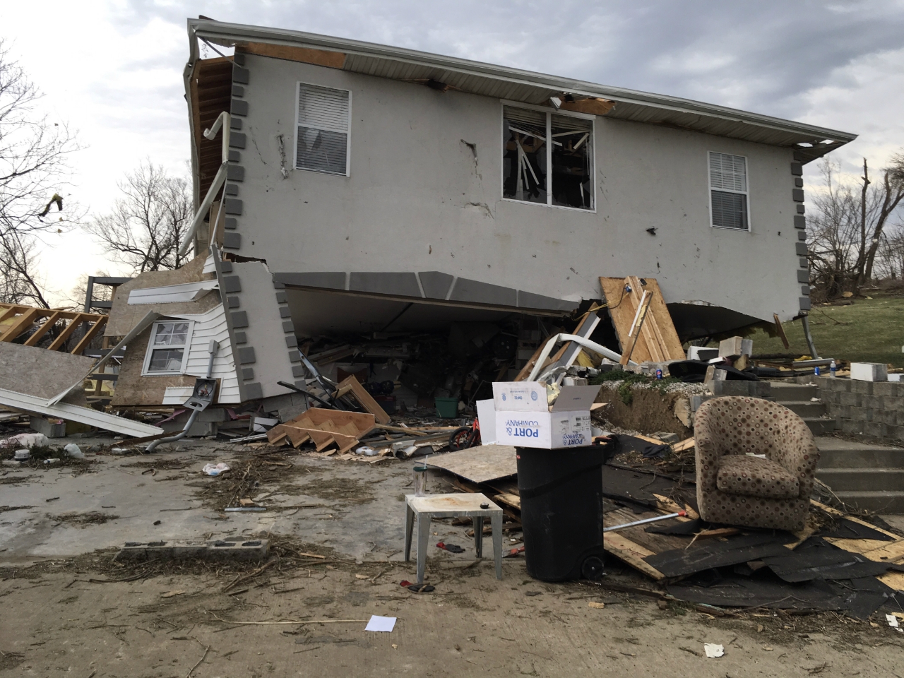
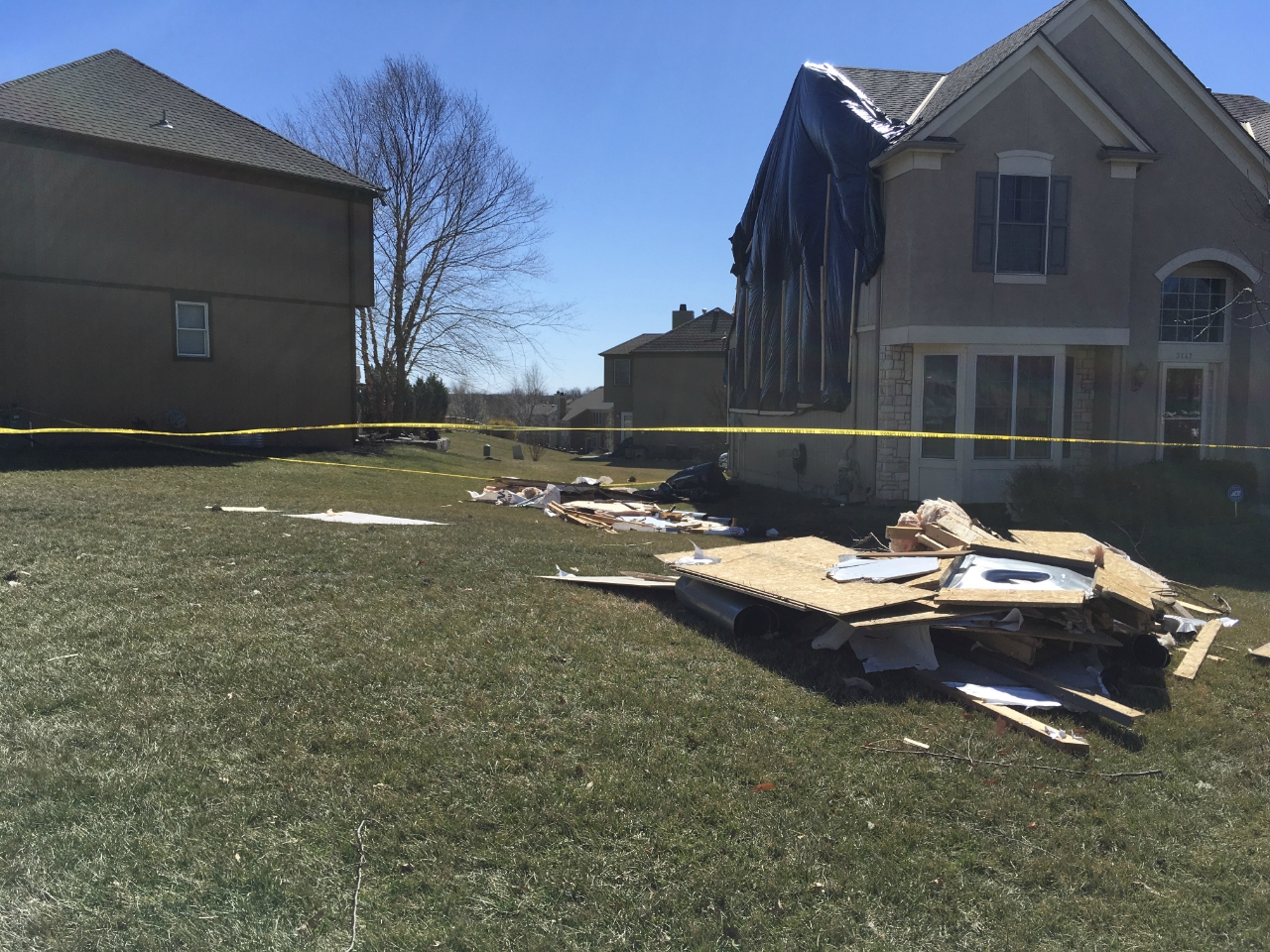
Oak Grove
 |
 |
 |
|
| Oak Grove Survey (NWS Pleasant Hill) |
Oak Grove Survey (NWS Pleasant Hill) |
Oak Grove Survey (NWS Pleasant Hill) |
Lee's Summit
 |
|||
| Lee's Summit Survey (NWS Pleasant Hill) |
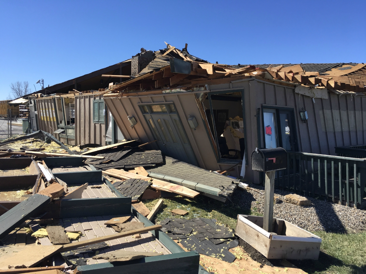
Carrollton
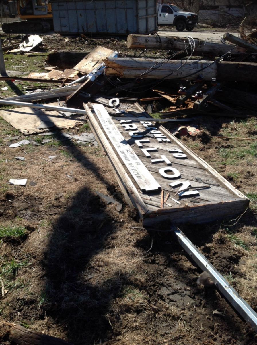 |
 |
 |
 |
| Carrollton Survey (NWS Pleasant Hill) |
Carrollton Survey (NWS Pleasant Hill) |
Carrollton Survey (NWS Pleasant Hill) |
Carrollton Survey (NWS Pleasant Hill) |
Leawood
 |
 |
||
| Leawood Survey (NWS Pleasant Hill) |
Leawood Survey (NWS Pleasant Hill) |
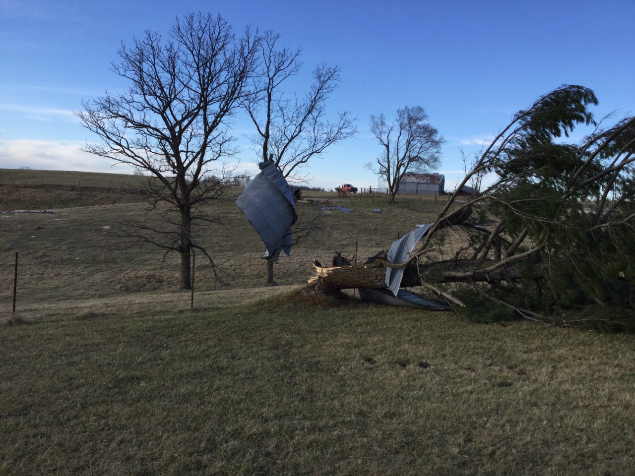
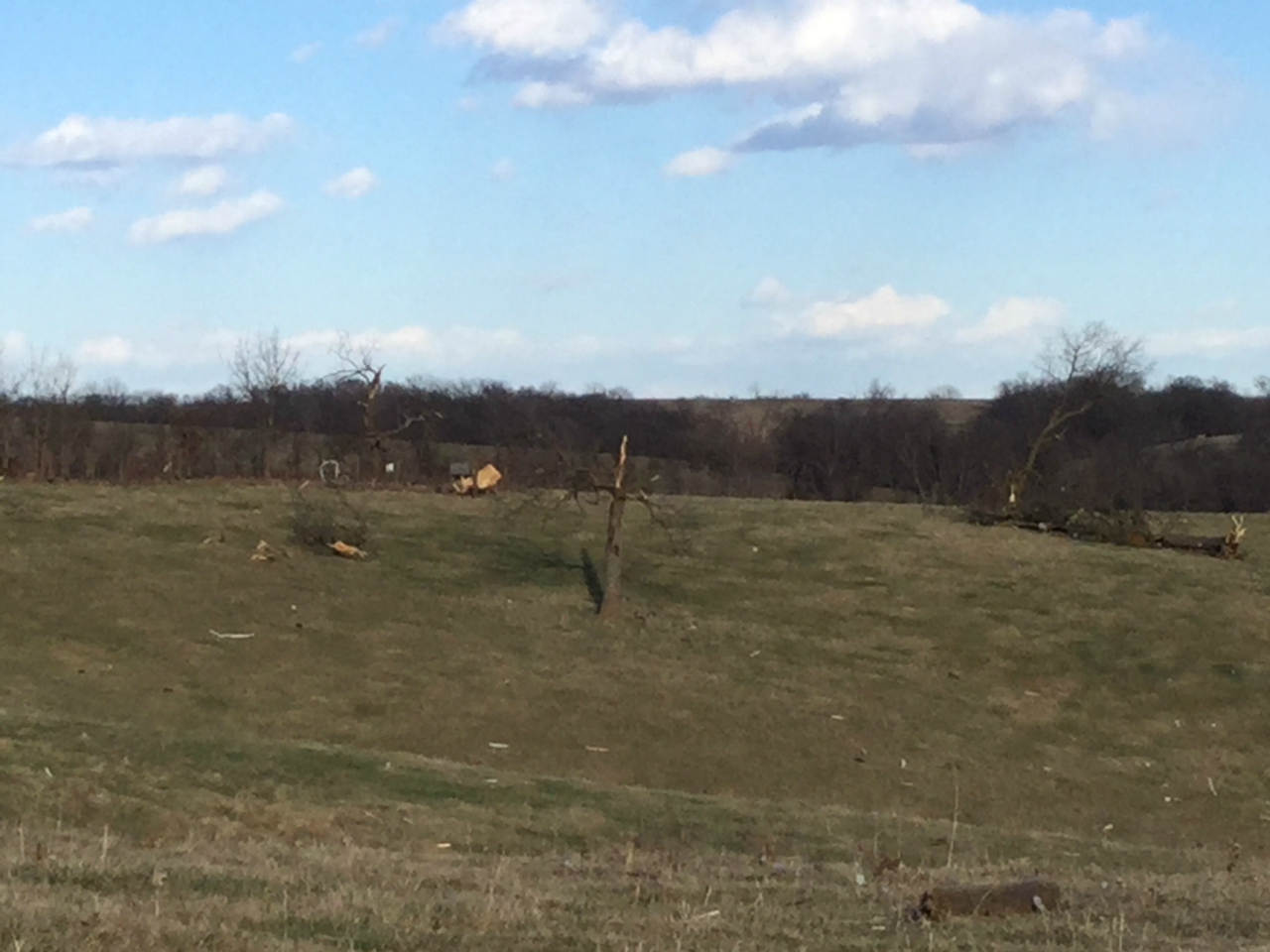
Mercer County
 |
 |
 |
|
| Mercer County Survey (NWS Des Moines) |
Mercer County Survey (NWS Des Moines) |
Mercer County Survey (NWS Des Moines) |
Radar:
Reflectivity
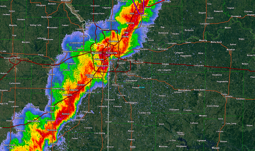 |
| Radar Loop - March 6, 2017 |
Storm Reports
PRELIMINARY LOCAL STORM REPORT...SUMMARY
NATIONAL WEATHER SERVICE KANSAS CITY/PLEASANT HILL MO
421 PM CST WED MAR 8 2017
..TIME... ...EVENT... ...CITY LOCATION... ...LAT.LON...
..DATE... ....MAG.... ..COUNTY LOCATION..ST.. ...SOURCE....
..REMARKS..
1145 PM HAIL 3 SSE LAKE QUIVIRA 39.00N 94.75W
03/06/2017 E1.75 INCH JOHNSON KS EMERGENCY MNGR
GOLF BALL SIZE HAIL REPORTED ON W 71ST ST
NEAR WIDMER RD.
1108 PM HAIL 3 NNE DE SOTO 39.02N 94.95W
03/06/2017 E1.50 INCH LEAVENWORTH KS EMERGENCY MNGR
EM REPORTS PING PONG SIZE HAIL AT 158TH ST
AND KREIDER RD.
0955 PM TSTM WND DMG 6 ESE ARMSTRONG 39.24N 92.60W
03/06/2017 HOWARD MO LAW ENFORCEMENT
LARGE LIMBS DOWN OVER STATE ROUTE H. MODOT
HAD TO BE CALLED IN TO REMOVE THEM.
0955 PM HAIL NEW FRANKLIN 39.01N 92.74W
03/06/2017 E0.88 INCH HOWARD MO LAW ENFORCEMENT
.
0955 PM TSTM WND DMG NEW FRANKLIN 39.01N 92.74W
03/06/2017 HOWARD MO LAW ENFORCEMENT
A FEW BROKEN RESIDENTIAL WINDOWS, MULTIPLE
MAILBOXES AND ROAD SIGNS BLOWN OVER, A
WOODEN GATE COMPLETELY SHATTERED.
0945 PM TSTM WND DMG 3 ESE PILOT GROVE 38.86N 92.85W
03/06/2017 COOPER MO EMERGENCY MNGR
WINDOWS BLOWN OUT OF HOUSE AND TREES DOWN.
POSSIBLE TORNADO...DAMAGE CONTINUES IN A
STRAIGHT LINE FROM THE PREVIOUS REPORT SW OF
PILOT GROVE.
0940 PM TSTM WND DMG 5 ENE CLIFTON CITY 38.80N 92.96W
03/06/2017 COOPER MO EMERGENCY MNGR
TREES DOWN AND GRAIN BIN MOVED. POSSIBLE
TORNADO...DAMAGE CONTINUES IN STRAIGHT LINE
TO THE INTERSECTION OF HIGHWAY 5 AND MILE
CORNER ROAD.
0933 PM TSTM WND GST SEDALIA MEMORIAL ARPT 38.71N 93.18W
03/06/2017 M58 MPH PETTIS MO ASOS
KDMO ASOS REPORTED 50 KNOTS.
0932 PM TORNADO BEVIER 39.75N 92.56W
03/06/2017 MACON MO EMERGENCY MNGR
EM RELAYED REPORT FROM COUNTY SHERIFF OF
TORNADO SOUTH OF BEVIER, ALONG WITH 60+ MPH
WINDS.
0932 PM HAIL LA PLATA 40.03N 92.49W
03/06/2017 E0.75 INCH MACON MO FIRE DEPT/RESCUE
0931 PM HAIL BEVIER 39.75N 92.56W
03/06/2017 E1.00 INCH MACON MO EMERGENCY MNGR
NICKEL TO QUARTER SIZE HAIL .
0931 PM TSTM WND GST MACON 39.74N 92.47W
03/06/2017 E60 MPH MACON MO EMERGENCY MNGR
0930 PM TSTM WND DMG 1 N GREEN RIDGE 38.63N 93.41W
03/06/2017 PETTIS MO EMERGENCY MNGR
POWER LINE DOWN ACROSS HWY 127.
0930 PM TSTM WND DMG 5 ESE LA MONTE 38.75N 93.34W
03/06/2017 PETTIS MO EMERGENCY MNGR
10 INCH TREE LIMBS DOWN.
0930 PM TSTM WND DMG 5 ESE LA MONTE 38.75N 93.34W
03/06/2017 PETTIS MO EMERGENCY MNGR
RV TURNED OVER AT HWY T AND MENEFEE RD. .
0927 PM TSTM WND DMG TIGHTWAD 38.31N 93.54W
03/06/2017 HENRY MO TRAINED SPOTTER
DELAYED REPORT. LARGE TREES 2 FT IN DIAMETER
UPROOTED. TIME MATCHED TO RADAR.
0925 PM TSTM WND GST KIRKSVILLE REGIONAL 40.10N 92.54W
03/06/2017 M60 MPH ADAIR MO ASOS
KIRK ASOS REPORTED 52 KNOTS.
0925 PM HAIL MARCELINE 39.72N 92.95W
03/06/2017 E0.88 INCH LINN MO PUBLIC
.
0925 PM TSTM WND GST KIRKSVILLE 40.19N 92.58W
03/06/2017 M60 MPH ADAIR MO ASOS
0923 PM HAIL MARSHALL 39.13N 93.20W
03/06/2017 E0.25 INCH SALINE MO PUBLIC
.
0919 PM TSTM WND DMG 3 W COAL 38.33N 93.67W
03/06/2017 HENRY MO PUBLIC
DELAYED REPORT. POWER LINES ON WEST SIDE OF
HIGHWAY W BETWEEN SE 250 RD AND SE 300 RD
DOWN AND BLOCKING ROADWAY. APPROXIMATELY 10
POLES DOWN. TIME MATCHED FROM RADAR.
0915 PM TSTM WND DMG GREEN CASTLE 40.26N 92.88W
03/06/2017 SULLIVAN MO TRAINED SPOTTER
POWER OUTAGE.
0915 PM FUNNEL CLOUD TIGHTWAD 38.32N 93.54W
03/06/2017 HENRY MO TRAINED SPOTTER
.
0915 PM TSTM WND DMG TIGHTWAD 38.31N 93.54W
03/06/2017 HENRY MO TRAINED SPOTTER
12 INCH DIAMETER BRADFORD PEAR COMPLETELY
BROKE.
0914 PM TSTM WND GST WHITEMAN AIR FORCE BASE 38.73N 93.56W
03/06/2017 M67 MPH JOHNSON MO ASOS
ASOS AT WHITEMAN AFB REPORTED 58 KNOTS.
0908 PM TSTM WND GST MARCELINE 39.71N 92.95W
03/06/2017 E60 MPH LINN MO TRAINED SPOTTER
0900 PM TSTM WND DMG 4 W STANLEY 38.85N 94.74W
03/06/2017 JOHNSON KS EMERGENCY MNGR
HANGER DESTROYED AT EXECUTIVE AIRPORT.
0857 PM TSTM WND DMG 1 S MENDON 39.58N 93.13W
03/06/2017 CHARITON MO EMERGENCY MNGR
EM RELAYED REPORT 2X4S ACROSS THE ROAD,
HOUSE ROOF BLOWN OFF, POWER POLES SNAPPED.
0857 PM TSTM WND DMG MENDON 39.59N 93.13W
03/06/2017 CHARITON MO AMATEUR RADIO
REPORT FROM RAILROAD EMPLOYEE OF TRAIN
ROCKING BACK AND FORTH, CAUSING A POSSIBLE
MINOR TRAIN DERAILMENT AND FORCING TRAINS TO
STOP MOVING IN THE AREA.
0855 PM TSTM WND DMG 1 SSE MENDON 39.58N 93.13W
03/06/2017 CHARITON MO EMERGENCY MNGR
POWER POLES SNAPPED...2 BY 4S SCATTERED
ACROSS THE ROAD.
0853 PM TSTM WND DMG HOLDEN 38.72N 93.99W
03/06/2017 JOHNSON MO FIRE DEPT/RESCUE
TREE FELL ON MOBILE HOME WITH THREE PEOPLE
TRAPPED INSIDE.
0852 PM HAIL WAVERLY 39.21N 93.52W
03/06/2017 E1.50 INCH LAFAYETTE MO PUBLIC
0848 PM TSTM WND DMG 3 E GARDEN CITY 38.55N 94.13W
03/06/2017 CASS MO LAW ENFORCEMENT
DEBRIS FROM A BARN OVER THE ROAD AT N HWY
AND CHANDLER RD. .
0846 PM TSTM WND DMG 1 E PASSAIC 38.32N 94.33W
03/06/2017 BATES MO EMERGENCY MNGR
DELAYED REPORT. HALF DOZEN BARNS TOPPLED
NEAR HIGHWAY D. TIME MATCHED TO RADAR.
0846 PM TSTM WND DMG GARDEN CITY 38.56N 94.19W
03/06/2017 CASS MO LAW ENFORCEMENT
TREES AND POWER LINES DOWN.
0843 PM TSTM WND GST 3 W CENTERVIEW 38.75N 93.90W
03/06/2017 M60 MPH JOHNSON MO NWS EMPLOYEE
0841 PM FLASH FLOOD 1 SW KANSAS CITY 39.09N 94.59W
03/06/2017 JACKSON MO DEPT OF HIGHWAYS
HIGH WATER ON NB I-35 AT WEST PENNWAY ST.
LEFT 2 LANES CLOSED.
0840 PM TSTM WND DMG 1 NNW CARROLLTON 39.37N 93.50W
03/06/2017 CARROLL MO EMERGENCY MNGR
MAJOR DAMAGE. 1 POWER POLE FELL ON A VEHICLE
WITH PEOPLE IN IT. THEY WERE RESCUED AND
UNHARMED. THERE ARE ALSO POWER LINES OVER
THE RAILROAD.
0840 PM TORNADO CARROLLTON 39.37N 93.50W
03/06/2017 CARROLL MO EMERGENCY MNGR
MAJOR DAMAGE. 1 POWER POLE FELL ON A VEHICLE
WITH PEOPLE IN IT. THEY WERE RESCUED AND
UNHARMED. THERE ARE ALSO POWER LINES OVER
THE RAILROAD.
0835 PM TSTM WND DMG LEXINGTON 39.18N 93.87W
03/06/2017 LAFAYETTE MO EMERGENCY MNGR
CAR PORT BLOWN INTO ROADWAY.
0835 PM HAIL 1 W CHULA 39.92N 93.50W
03/06/2017 E1.00 INCH LIVINGSTON MO FIRE DEPT/RESCUE
FIRE CHIEF REPORTED QUARTER SIZE HAIL.
0832 PM TSTM WND GST MILAN 40.20N 93.13W
03/06/2017 M55 MPH SULLIVAN MO EMERGENCY MNGR
55MPH GUST MEASURED.
0829 PM TSTM WND DMG ODESSA 39.00N 93.95W
03/06/2017 LAFAYETTE MO FIRE DEPT/RESCUE
TWO HOMES COMPLETELY DESTROYED AND NUMEROUS
OTHERS DAMAGED...ROOF OFF WATER PLANT AND
DAMAGES TO THE POWER GRID. NO REPORTED
INJURIES OR TRANSPORTS.
0827 PM TSTM WND DMG LEXINGTON 39.18N 93.87W
03/06/2017 LAFAYETTE MO EMERGENCY MNGR
CITY EM REPORTED CAR PORT BLOWN INTO A
ROADWAY.
0826 PM HAIL CHILLICOTHE 39.80N 93.56W
03/06/2017 E1.00 INCH LIVINGSTON MO TRAINED SPOTTER
.
0826 PM TSTM WND GST CHILLICOTHE 39.80N 93.56W
03/06/2017 E65 MPH LIVINGSTON MO PUBLIC
.
0826 PM TSTM WND DMG 5 S RUSSELLVILLE 39.34N 93.83W
03/06/2017 RAY MO PUBLIC
DELAYED REPORT VIA SOCIAL MEDIA. MULTIPLE
BARNS DOWN AND TREES UPROOTED. TIME MATCHED
TO RADAR.
0825 PM TSTM WND DMG 5 E PARKER 38.33N 94.90W
03/06/2017 LINN KS EMERGENCY MNGR
BUILDING DESTROYED.
0823 PM TSTM WND GST UNIONVILLE 40.48N 93.01W
03/06/2017 E70 MPH PUTNAM MO 911 CALL CENTER
UNIONVILLE DISPATCH RELAYED REPORTS OF
ESTIMATED 70MPH WINDS AND 2 FUNNEL CLOUDS IN
THE AREA PER SPOTTERS.
0820 PM TORNADO OAK GROVE 39.01N 94.13W
03/06/2017 JACKSON MO FIRE DEPT/RESCUE
*** 15 INJ *** SIGNIFICANT DAMAGE TO HOMES
IN OAK GROVE. NO INJURIES ARE LIFE
THREATENING.
0820 PM TSTM WND DMG 4 W LA CYGNE 38.35N 94.84W
03/06/2017 LINN KS 911 CALL CENTER
WIDESPREAD WIND DAMAGE ACROSS NORTHERN LINN
COUNTY. SEVERAL TREES DOWN. OUTBUILDINGS
FLATTENED.
0820 PM HAIL 2 WNW MISSOURI CITY 39.25N 94.33W
03/06/2017 E0.25 INCH CLAY MO TRAINED SPOTTER
.
0817 PM TSTM WND DMG 1 S PARKER 38.32N 94.99W
03/06/2017 LINN KS EMERGENCY MNGR
EM REPORTED HOUSE DAMAGED WITH WINDOWS BLOWN
OUT NEAR W 2000TH RD AND CR 1077.
0815 PM HAIL 5 WSW BUCKNER 39.10N 94.28W
03/06/2017 E1.75 INCH JACKSON MO PUBLIC
0815 PM TSTM WND DMG 4 WSW PARKER 38.30N 95.06W
03/06/2017 LINN KS EMERGENCY MNGR
LARGE TREES DOWN.
0813 PM TSTM WND DMG BRAYMER 39.59N 93.80W
03/06/2017 CALDWELL MO FIRE DEPT/RESCUE
DAMAGE TO OUTBUILDINGS.
0812 PM TSTM WND DMG 3 SE GENTRY 40.31N 94.38W
03/06/2017 GENTRY MO 911 CALL CENTER
REPORT OF A SHED'S ROOF BLOWN ONTO THE ROAD
APPROX. 4 MILES NORTH OF HWY 136 ON ROUTE N.
0811 PM HAIL 2 ENE INDEPENDENCE 39.11N 94.38W
03/06/2017 E1.75 INCH JACKSON MO EMERGENCY MNGR
RELAYED REPORT OF GOLF BALL SIZE HAIL AT HWY
291 AND SALISBURY RD.
0811 PM HAIL 3 NW LAKE TAPAWINGO 39.05N 94.35W
03/06/2017 E1.00 INCH JACKSON MO FIRE DEPT/RESCUE
AMBULANCE REPORTED QUARTER SIZE HAIL AT
CENTERPOINT HOSPITAL IN INDEPENDENCE .
0809 PM HAIL 1 N RANDOLPH 39.17N 94.49W
03/06/2017 E0.50 INCH CLAY MO PUBLIC
.
0808 PM HAIL 2 ESE INDEPENDENCE 39.08N 94.39W
03/06/2017 E1.00 INCH JACKSON MO TRAINED SPOTTER
SPOTTER REPORTED 1 INCH HAIL NEAR 23RD ST
AND LEES SUMMIT RD.
0808 PM TSTM WND GST 2 ENE UNITY VILLAGE 38.96N 94.37W
03/06/2017 M64 MPH JACKSON MO ASOS
KLXT MEASURED 56 KNOT GUST.
0808 PM TSTM WND DMG PARKER 38.33N 94.99W
03/06/2017 LINN KS FIRE DEPT/RESCUE
EM RELAYED REPORT FROM FIRE DEPT OF POWER
LINES DOWN AND POWER OUT IN PARKER.
0807 PM HAIL 1 SSW UNITY VILLAGE 38.93N 94.41W
03/06/2017 E1.00 INCH JACKSON MO AMATEUR RADIO
QUARTER SIZE HAIL REPORTED AT HWY 50 AND
I-470.
0805 PM HAIL 3 W SUGAR CREEK 39.11N 94.50W
03/06/2017 E1.00 INCH JACKSON MO PUBLIC
.
0805 PM TSTM WND DMG 4 ENE LAWSON 39.45N 94.14W
03/06/2017 RAY MO EMERGENCY MNGR
6 INCH LIMBS DOWN.
0805 PM TSTM WND DMG 1 NE LEE'S SUMMIT 38.92N 94.37W
03/06/2017 JACKSON MO NWS EMPLOYEE
18-20 INCH DIAMETER TREE KNOCKED OVER. 6-10
INCH DIAMETER BRANCHES IN THE ROADWAY. .
0805 PM HAIL INDEPENDENCE 39.09N 94.42W
03/06/2017 E2.00 INCH JACKSON MO PUBLIC
0805 PM TSTM WND DMG 1 NE LEE'S SUMMIT 38.93N 94.37W
03/06/2017 JACKSON MO 911 CALL CENTER
DISPATCH REPORTED ROOF BLOWN OFF HOUSE,
ALONG WITH OTHER DAMAGE, NEAR INDEPENDENCE
AVE AND ENGLISH MANOR DR.
0804 PM HAIL 2 NNE RAYTOWN 39.03N 94.46W
03/06/2017 E1.00 INCH JACKSON MO PUBLIC
.
0803 PM TSTM WND GST 1 N TRENTON 40.09N 93.62W
03/06/2017 E60 MPH GRUNDY MO FIRE DEPT/RESCUE
EM RELAYED REPORT FROM GRUNDY COUNTY FIRE
DEPT OF AT LEAST 60 MPH WINDS NORTH OF
TRENTON.
0802 PM HEAVY RAIN 4 NW BUCYRUS 38.77N 94.76W
03/06/2017 E2.00 INCH JOHNSON KS EMERGENCY MNGR
EM RELAYED REPORT OF 2 INCHES OF RAIN AT
199TH ST AND LACKMAN RD.
0801 PM HAIL 1 W RAYTOWN 39.01N 94.49W
03/06/2017 E1.75 INCH JACKSON MO BROADCAST MEDIA
GOLF BALL SIZE HAIL REPORTED AT HWY 350 AND
63RD ST.
0800 PM TSTM WND DMG 2 ENE STANLEY 38.87N 94.63W
03/06/2017 JOHNSON KS EMERGENCY MNGR
MAJOR DAMAGE TO HOMES, INCLUDING ROOFS,
WALLS, AND GARAGES. THERE IS ALSO HEAVY TREE
DAMAGE.
0800 PM TSTM WND DMG 1 S GRANDVIEW 38.87N 94.53W
03/06/2017 JACKSON MO LAW ENFORCEMENT
POWER LINES DOWN ON ROAD.
0800 PM TSTM WND DMG 4 W STANLEY 38.85N 94.74W
03/06/2017 JOHNSON KS EMERGENCY MNGR
HANGER DESTROYED AT EXECUTIVE AIRPORT.
0759 PM TSTM WND DMG 1 W PAOLA 38.58N 94.88W
03/06/2017 MIAMI KS LAW ENFORCEMENT
ROOFS BLOWN OFF MULTIPLE HOMES AND BARNS
THROUGHOUT COUNTY. NUMEROUS POWER LINES AND
POWER POLES DOWN. SEVERAL METAL BUILDINGS
DESTROYED.
0759 PM TSTM WND GST 1 N JAMESPORT 39.99N 93.80W
03/06/2017 E70 MPH DAVIESS MO EMERGENCY MNGR
EM RELAYED REPORT OF EST. 70MPH WINDS NORTH
OF JAMESPORT.
0757 PM TORNADO GRANDVIEW 38.89N 94.53W
03/06/2017 JACKSON MO TRAINED SPOTTER
DAMAGE TO TREES AND MINOR STRUCTURAL DAMAGE.
POSSIBLE TORNADO. GRANDVIEW PD STATED THAT
SB I-49 WAS CLOSED AT 135TH ST.
0757 PM HAIL 5 SSW KANSAS CITY 39.04N 94.61W
03/06/2017 E1.25 INCH JACKSON MO AMATEUR RADIO
HALF DOLLAR SIZE HAIL REPORTED AT 50TH ST
AND STATE LINE RD.
0756 PM HAIL LATHROP 39.55N 94.33W
03/06/2017 E0.88 INCH CLINTON MO PUBLIC
.
0755 PM TSTM WND GST 1 NW MOSBY 39.33N 94.31W
03/06/2017 M68 MPH CLAY MO ASOS
KGPH MEASURED 59 KNOT GUST.
0755 PM TSTM WND GST 1 S KANSAS CITY 39.08N 94.58W
03/06/2017 E75 MPH JACKSON MO STORM CHASER
.
0755 PM TSTM WND GST 2 SW KANSAS CITY KANSAS 39.10N 94.65W
03/06/2017 E65 MPH WYANDOTTE KS TRAINED SPOTTER
SPOTTER REPORTED 60-70MPH ESTIMATED WINDS
WITH DIME SIZE HAIL NEAR 18TH STREET AND
I-70.
0755 PM HAIL 1 S KANSAS CITY 39.08N 94.58W
03/06/2017 U1.25 INCH JACKSON MO STORM CHASER
.
0755 PM TSTM WND DMG 1 SSW KANSAS CITY 39.08N 94.58W
03/06/2017 JACKSON MO STORM CHASER
ROOF DAMAGE TO THE WESTON HOTEL.
0755 PM TSTM WND DMG 1 S KANSAS CITY 39.08N 94.58W
03/06/2017 JACKSON MO STORM CHASER
POWER LINES AND TREES DOWN.
0754 PM TSTM WND DMG 4 S KANSAS CITY 39.04N 94.58W
03/06/2017 JACKSON MO BROADCAST MEDIA
WINDOWS BLOWN OUT OF BUSINESS IN WESTPORT.
0753 PM TSTM WND DMG 8 SSW EDGERTON 38.66N 95.05W
03/06/2017 MIAMI KS EMERGENCY MNGR
EM REPORTED POWER LINES DOWN NEAR 261ST AND
PLEASANT VALLEY ROAD.
0750 PM TSTM WND DMG 1 SSW KANSAS CITY 39.08N 94.58W
03/06/2017 JACKSON MO STORM CHASER
ROOF DAMAGE TO THE WESTON HOTEL.
0750 PM HAIL MUNCIE 39.09N 94.75W
03/06/2017 E0.88 INCH WYANDOTTE KS PUBLIC
.
0750 PM TSTM WND DMG 2 S KANSAS CITY 39.08N 94.58W
03/06/2017 JACKSON MO STORM CHASER
DAMAGE TO THE FRONT OF A CONDO BUILDING.
0749 PM TSTM WND DMG 2 N KANSAS CITY INTL AR 39.33N 94.72W
03/06/2017 PLATTE MO EMERGENCY MNGR
TRACTOR TRAILER OVERTURNED DUE TO WINDS.
0749 PM HAIL MERRIAM 39.02N 94.69W
03/06/2017 E1.50 INCH JOHNSON KS TRAINED SPOTTER
SPOTTER REPORTED 1.5 INCH HAIL IN MERRIAM.
0748 PM TSTM WND GST 4 W STANLEY 38.85N 94.74W
03/06/2017 M67 MPH JOHNSON KS ASOS
KOJC MEASURED 58 KNOT GUST.
0747 PM HAIL 2 SW EDWARDSVILLE 39.04N 94.84W
03/06/2017 E1.00 INCH JOHNSON KS TRAINED SPOTTER
1 INCH HAIL REPORTED NEAR 47TH ST AND
MONTICELLO RD.
0746 PM HAIL 2 SW KANSAS CITY KANSAS 39.09N 94.65W
03/06/2017 E2.00 INCH WYANDOTTE KS PUBLIC
0746 PM TSTM WND DMG 3 NE HOLT 39.49N 94.30W
03/06/2017 CLINTON MO DEPT OF HIGHWAYS
KC SCOUT REPORTED TRACTOR TRAILER ROLLOVER
ON SB I-35 AT MM 93.
0746 PM HAIL 1 N LAKE QUIVIRA 39.06N 94.76W
03/06/2017 E1.75 INCH WYANDOTTE KS BROADCAST MEDIA
MEDIA REPORTS GOLF BALL SIZE HAIL ON THE
GROUND 3 MILES EAST OF EDWARDSVILLE ON HWY
32.
0745 PM TSTM WND DMG GRAND PASS 39.21N 93.44W
03/06/2017 SALINE MO PUBLIC
TREE DOWN THE SIZE OF A TELEPHONE POLE.
0745 PM TSTM WND DMG 4 SE OLATHE 38.85N 94.76W
03/06/2017 JOHNSON KS PUBLIC
DELAYED REPORT. TREES DOWN AND SOME
UPROOTED. TIME MATCHED TO RADAR.
0745 PM HAIL 3 SSE LAKE QUIVIRA 39.00N 94.75W
03/06/2017 E1.75 INCH JOHNSON KS EMERGENCY MNGR
GOLF BALL SIZE HAIL REPORTED ON W 71ST ST
NEAR WIDMER RD.
0744 PM HEAVY RAIN 2 NNW EDGERTON 38.80N 95.02W
03/06/2017 M2.69 INCH JOHNSON KS EMERGENCY MNGR
RAIN TOTAL THUS FAR AT 183RD ST AND EDGERTON
RD.
0743 PM TSTM WND DMG 1 S LATHROP 39.54N 94.33W
03/06/2017 CLINTON MO LAW ENFORCEMENT
EM RELAYED REPORT FROM HIGHWAY PATROL OF
POWER LINES DOWN SOUTH OF LATHROP ON MO 33.
0743 PM HAIL 4 NNW OLATHE 38.94N 94.85W
03/06/2017 E1.00 INCH JOHNSON KS PUBLIC
.
0743 PM TORNADO LATHROP 39.55N 94.33W
03/06/2017 CLINTON MO PUBLIC
PHOTO OF BOARD DRIVEN THROUGH STONE FACADE
ON HOME...REPORT VIA SOCIAL MEDIA.
0740 PM TSTM WND GST 1 WNW CLARE 38.83N 94.89W
03/06/2017 M66 MPH JOHNSON KS ASOS
KIXD MEASURED 57 KNOT GUST.
0740 PM TSTM WND DMG 2 NNW EDGERTON 38.80N 95.02W
03/06/2017 JOHNSON KS EMERGENCY MNGR
POWER LINES DOWN AT 183RD JUST WEST OF
EDGERTON RD. REPORTED FROM A SPOTTER. .
0738 PM TORNADO MOUNT MORIAH 40.33N 93.80W
03/06/2017 HARRISON MO 911 CALL CENTER
DAMAGE TO HOME, OUTBUILDING AND TREES.
0738 PM TORNADO 4 S MOUNT MORIAH 40.28N 93.80W
03/06/2017 HARRISON MO EMERGENCY MNGR
POSSIBLY STARTED NEAR HWY CC AND HWY 136.
MOBILE HOME BLOW AWAY, BARN DAMAGE, AND HOME
DAMAGE NEAR THIS AREA AS WELL. POSSIBLE PATH
IS THROUGH MERCER TO SEYMOUR, IA.
0738 PM HAIL 2 W SHAWNEE 39.01N 94.85W
03/06/2017 E1.75 INCH JOHNSON KS TRAINED SPOTTER
EM RELAYED REPORT FROM SPOTTER OF GOLF BALL
SIZE HAIL AT K-7 AND SHAWNEE MISSION
PARKWAY.
0736 PM TSTM WND DMG 5 S PLATTSBURG 39.49N 94.47W
03/06/2017 CLINTON MO PUBLIC
EM RELAYED REPORT FROM THE PUBLIC OF HOUSE
DAMAGED AT J HWY AND MCCOMAS LANE.
0734 PM HAIL 3 SW SHAWNEE 38.98N 94.85W
03/06/2017 U2.00 INCH JOHNSON KS PUBLIC
.
0734 PM HAIL 2 NNE LENEXA 38.98N 94.72W
03/06/2017 M2.00 INCH JOHNSON KS PUBLIC
0732 PM TSTM WND GST 1 NNW PLATTE WOODS 39.25N 94.66W
03/06/2017 E60 MPH PLATTE MO AMATEUR RADIO
REPORTED NEAR I-29 AND BARRY RD.
0730 PM HAIL 3 NNE DE SOTO 39.02N 94.95W
03/06/2017 E1.50 INCH LEAVENWORTH KS EMERGENCY MNGR
EM REPORTS PING PONG SIZE HAIL AT 158TH ST
AND KREIDER RD.
0730 PM TORNADO 3 S MOUNT MORIAH 40.28N 93.80W
03/06/2017 HARRISON MO EMERGENCY MNGR
POSSIBLY STARTED NEAR HWY CC AND HWY 136.
MOBILE HOME BLOW AWAY, BARN DAMAGE, AND HOME
DAMAGE NEAR THIS AREA AS WELL. POSSIBLE PATH
IS THROUGH MERCER TO SEYMOUR, IA.
0729 PM HAIL 2 W SHAWNEE 39.01N 94.85W
03/06/2017 E1.00 INCH JOHNSON KS TRAINED SPOTTER
EM RELAYED REPORT FROM SPOTTER OF 1 INCH
HAIL NEAR K-7 AND SHAWNEE MISSION PARKWAY.
0729 PM HAIL 3 NW OLATHE 38.93N 94.85W
03/06/2017 E1.75 INCH JOHNSON KS TRAINED SPOTTER
EM RELAYED REPORT FROM SPOTTER OF GOLF BALL
SIZE HAIL NEAR 111TH AND K-7.
0729 PM HAIL DE SOTO 38.98N 94.97W
03/06/2017 E1.25 INCH JOHNSON KS EMERGENCY MNGR
EM REPORTS 1.25 INCH HAIL IN DE SOTO.
0729 PM HAIL EDGERTON 39.51N 94.63W
03/06/2017 U2.75 INCH PLATTE MO PUBLIC
.
0727 PM TSTM WND DMG 1 N BETHANY 40.28N 94.03W
03/06/2017 HARRISON MO EMERGENCY MNGR
DELAYED REPORT. TRACTOR TRAILER BLOWN OVER
ON I-35 NEAR BETHANY AT MM 93. TIME MATCHED
TO RADAR.
0727 PM TORNADO 2 S TRIMBLE 39.45N 94.57W
03/06/2017 CLAY MO LAW ENFORCEMENT
POSSIBLE TORNADO DAMAGE. 8-12 HOUSES
DAMAGED. 4-5 ARE UNINHABITABLE, THE REST
HAVE MINOR DAMAGE. .
0727 PM TSTM WND DMG 4 SSW CAINSVILLE 40.39N 93.80W
03/06/2017 HARRISON MO EMERGENCY MNGR
DELAYED REPORT. FRONT PORCH BLOWN OFF HOME.
ADDITIONAL DAMAGE TO TWO OUT BUILDINGS. TIME
MATCHED TO RADAR.
0727 PM TORNADO 4 WSW LATHROP 39.53N 94.40W
03/06/2017 CLINTON MO EMERGENCY MNGR
POSSIBLE TORNADO DAMAGE FROM JUST SOUTH OF
TRIMBLE TO JUST EAST OF LATHROP. WIDESPREAD
STRUCTURAL, UTILITY, AND VEGETATION DAMAGE
RANGING FROM MINOR TO MAJOR. POWER IS OUT
ALONG THE PATH. MAY TAKE 24-48 HOURS TO
RESTORE. NUMEROUS ROADS ARE BLOCKED BY
DEBRIS. .
0726 PM HAIL TRIMBLE 39.47N 94.56W
03/06/2017 M1.00 INCH CLINTON MO TRAINED SPOTTER
SPOTTER MEASURED QUARTER SIZE HAIL, ALONG
WITH POWER OUTAGES IN TOWN.
0725 PM HAIL 1 SSW TRIMBLE 39.45N 94.57W
03/06/2017 E2.75 INCH CLAY MO PUBLIC
.
0725 PM FUNNEL CLOUD 1 W MAYSVILLE 39.89N 94.39W
03/06/2017 DEKALB MO EMERGENCY MNGR
DEPUTY EM FROM HARRISON COUNTY REPORTED
FUNNEL CLOUD WEST OF I-35 AND HWY 6.
0724 PM TSTM WND GST KANSAS CITY INTL ARPT 39.30N 94.71W
03/06/2017 M67 MPH PLATTE MO ASOS
ASOS AT MCI REPORTED 58 KNOTS AT 0124Z AND
0132Z.
0724 PM TSTM WND DMG 1 ESE CLEARVIEW CITY 38.94N 94.99W
03/06/2017 JOHNSON KS PUBLIC
DELAYED REPORT. TREE BLOWN DOWN ONTO HOUSE
ON ROSEWOOD AVENUE. TIME MATCHED TO RADAR.
0723 PM TSTM WND DMG 2 S FAIRMOUNT 39.17N 94.94W
03/06/2017 LEAVENWORTH KS EMERGENCY MNGR
POWER POLE DOWN.
0722 PM TSTM WND GST 2 W CLEARVIEW CITY 38.94N 95.04W
03/06/2017 E60 MPH JOHNSON KS TRAINED SPOTTER
.
0722 PM TORNADO 3 N KANSAS CITY INTL AR 39.33N 94.72W
03/06/2017 PLATTE MO TRAINED SPOTTER
SPOTTER REPORTS A TORNADO .
0720 PM TSTM WND GST 1 S SMITHVILLE 39.38N 94.58W
03/06/2017 E60 MPH CLAY MO AMATEUR RADIO
NORTHLAND ARES REPORTED ESTIMATED 60MPH
WINDS, WITH TRAILERS BEING MOVED. NEAR THE
SMITHVILLE HOSPITAL.
0716 PM TSTM WND DMG PARKVILLE 39.19N 94.69W
03/06/2017 PLATTE MO EMERGENCY MNGR
EM REPORTS POWER LINES DOWN AT WEST AND 11TH
ST.
0716 PM TSTM WND DMG 1 SW PLATTE WOODS 39.22N 94.66W
03/06/2017 PLATTE MO EMERGENCY MNGR
POWER LINES DOWN AT NW 70TH ST AND MONTROSE
AVE.
0713 PM TSTM WND GST TONGANOXIE 39.11N 95.09W
03/06/2017 E50 MPH LEAVENWORTH KS EMERGENCY MNGR
TRANSFORMER BLOWN WITH POWER POLES DOWN.
0704 PM HAIL 4 SSW FARMINGTON 39.47N 95.34W
03/06/2017 E1.00 INCH ATCHISON KS TRAINED SPOTTER
.
0701 PM HAIL 3 SE EASTON 39.31N 95.07W
03/06/2017 E1.75 INCH LEAVENWORTH KS EMERGENCY MNGR
EM REPORTS GOLF BALL SIZE HAIL AT 207TH AND
SPRINGDALE ROAD.
0657 PM HAIL 3 WSW LEAVENWORTH 39.30N 94.97W
03/06/2017 E1.00 INCH LEAVENWORTH KS EMERGENCY MNGR
EM REPORTS 1/2 TO QUARTER SIZE HAIL ON
SPRINGDALE IN LEAVENWORTH.
0655 PM HAIL RAVENWOOD 40.36N 94.67W
03/06/2017 E1.50 INCH NODAWAY MO TRAINED SPOTTER
EM RELAYED REPORT FROM SPOTTER OF PING PONG
BALL SIZE HAIL IN RAVENWOOD .
0655 PM HAIL PARNELL 40.44N 94.62W
03/06/2017 E0.75 INCH NODAWAY MO FIRE DEPT/RESCUE
DIME SIZE HAIL IN PARNELL. TIME ESTIMATED.
0655 PM HAIL 1 ENE RAVENWOOD 40.36N 94.65W
03/06/2017 E1.75 INCH NODAWAY MO TRAINED SPOTTER
UP TO GOLF BALL, SAW A LOT OF QUARTER SIZE
AS WELL. HAIL IS COVERING THE ROADS.
0652 PM HAIL CONCEPTION 40.25N 94.68W
03/06/2017 E1.25 INCH NODAWAY MO PUBLIC
DELAYED REPORT. DAMAGE TO VINYL SIDING ON
WEST SIDE OF HOME. TIME MATCHED TO RADAR.
0651 PM TSTM WND DMG 5 NW RAVENWOOD 40.40N 94.74W
03/06/2017 NODAWAY MO PUBLIC
EM RELAYED REPORT FROM CITIZEN OF SHED BLOWN
INTO ROAD ON 220TH STREET NEAR RAVENWOOD.
0648 PM HAIL PARNELL 40.44N 94.62W
03/06/2017 E1.00 INCH NODAWAY MO TRAINED SPOTTER
.
0642 PM HAIL 3 N MARYVILLE 40.39N 94.87W
03/06/2017 E1.00 INCH NODAWAY MO FIRE DEPT/RESCUE
PICKERING FIRE REPORTED QUARTER SIZE HAIL ON
HWY 71 VIA EM.
0635 PM TORNADO 2 WSW MARYVILLE 40.34N 94.91W
03/06/2017 NODAWAY MO PUBLIC
LAW ENFORCEMENT RELAYED REPORT FROM THE
PUBLIC OF A BRIEF TORNADO WEST OF MARYVILLE.
0632 PM HAIL 3 W MARYVILLE 40.35N 94.93W
03/06/2017 E0.88 INCH NODAWAY MO LAW ENFORCEMENT
NICKEL SIZE HAIL REPORTED FROM LAW
ENFORCEMENT VIA EM 3 MILES WEST OF
MARYVILLE.
0630 PM TORNADO 2 NNE SKIDMORE 40.31N 95.07W
03/06/2017 NODAWAY MO FIRE DEPT/RESCUE
WEST NODAWAY FIRE REPORTED A BRIEF TORNADO
ON HWY 113.
0625 PM TSTM WND DMG 1 E FOREST CITY 39.98N 95.17W
03/06/2017 HOLT MO LAW ENFORCEMENT
SHERIFF DEPT REPORTED TREES DOWN BETWEEN
FOREST CITY AND OREGON.
0618 PM TSTM WND DMG MOUND CITY 40.13N 95.24W
03/06/2017 HOLT MO LAW ENFORCEMENT
EM RELAYED REPORT FROM HIGHWAY PATROL OF
SEMI TRUCK ROLLED OVER ON I-29 AT MM84.
0618 PM TSTM WND DMG MOUND CITY 40.14N 95.23W
03/06/2017 HOLT MO LAW ENFORCEMENT
SHERIFF DEPT REPORTED POWER LINES DOWN.
0617 PM TORNADO 1 WSW MOUND CITY 40.13N 95.26W
03/06/2017 HOLT MO FIRE DEPT/RESCUE
HOLT COUNTY SHERIFF DEPT RELAYED REPORT FROM
MOUND CITY FIRE DEPT OF A BRIEF TORNADO JUST
WEST OF MOUND CITY.
0536 PM HAIL 3 W WESTBORO 40.54N 95.38W
03/06/2017 M1.75 INCH ATCHISON MO EMERGENCY MNGR
.
0534 PM HAIL 4 WNW WESTBORO 40.57N 95.39W
03/06/2017 E1.00 INCH ATCHISON MO 911 CALL CENTER
DISPATCH RELAYED REPORT OF 1 INCH SIZE HAIL
APPROX. 1 MILE SOUTH OF THE IA BORDER ON US
HWY 59.
&&
$$
 |
Media use of NWS Web News Stories is encouraged! Please acknowledge the NWS as the source of any news information accessed from this site. |
|


 Weather Story
 Weather Map
 Local Radar