
A slow moving front will bring rounds of strong to severe thunderstorms and heavy rainfall to the central Plains eastward to the east-central U.S.. The first widespread significant heat wave of summer for the Intermountain West and Plains is expected to develop today and expand through next week. Dangerous heat will continue to impact portions of the Southwest and Southeast. Read More >
Overview
|
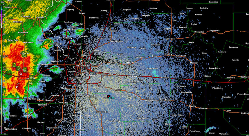
During the afternoon of July 14, 2023 a strong storm formed in northeast Kansas and eventually transformed into a strong squall line that impacted far eastern Kansas and western Missouri. This storm left a swath of wind damage mainly through the heart of the Kansas City metro area in the form of widespread tree damage. Several structures were impacted by falling trees as the storm moved through the city, and into central Missouri. The highest reported wind gust came from western Johnson County where a personal weather station recorded 89 mph wind just west of Lenexa. Numerous wind reports, both estimated and measured were over 70 mph. At one point nearly 200,000 people across the Kansas City metro lost power. As of the next day, roughly 60,000 Kansas Citians were still without power. |
 Storm reports from July 14, 2023 |
Radar
Header
 |
 |
| Radar reflectivity from KEAX in Pleasant Hill Missouri showing the strong thunderstorm moving through the Kansas City metro, along with time appropriate storm reports. | Radar velocity indicating the strongest winds through the Kansas City metro. Note the bright green (toward the radar) and red (away from the radar) as the winds move through KC and Pleasant Hill. |
Storm Reports
Preliminary Local Storm Report...Summary
National Weather Service Kansas City/Pleasant HIll MO
212 PM CDT Sat Jul 15 2023

..TIME...   ...EVENT...      ...CITY LOCATION...     ...LAT.LON...
..DATE...   ....MAG....      ..COUNTY LOCATION..ST.. ...SOURCE....
            ..REMARKS..

0314 PM     Tstm Wnd Gst     3 W Jarbalo             39.20N 95.12W
07/14/2023  E60 MPH          Leavenworth        KS   Trained Spotter


0317 PM     Tstm Wnd Gst     2 W Clearview City      38.95N 95.03W
07/14/2023  E60 MPH          Johnson            KS   NWS Employee

            Delayed Report...

0325 PM     Tstm Wnd Dmg     Tonganoxie              39.11N 95.08W
07/14/2023                   Leavenworth        KS   Emergency Mngr

            Tree downed into power lines in Tonganoxie.

0329 PM     Tstm Wnd Gst     3 W Jarbalo             39.20N 95.12W
07/14/2023  E60 MPH          Leavenworth        KS   Emergency Mngr

            Heavy Rain, low visibility.

0334 PM     Tstm Wnd Dmg     3 SSW Basehor           39.10N 94.96W
07/14/2023                   Leavenworth        KS   Emergency Mngr

            Delayed Report... Several tree branches down
            in the area of 168th and Evans Road.

0339 PM     Tstm Wnd Gst     2 SW Lake Quivira       39.02N 94.79W
07/14/2023  E70 MPH          Johnson            KS   Trained Spotter


0343 PM     Hail             1 NW Ferrelview         39.32N 94.67W
07/14/2023  E1.00 inch       Platte             MO   Public

            Report from mPING: Quarter (1.00 in.).

0343 PM     Tstm Wnd Dmg     2 WNW Merriam           39.04N 94.72W
07/14/2023                   Johnson            KS   Emergency Mngr

            Delayed Report... Tree down at 51st and
            Quivira.

0345 PM     Tstm Wnd Dmg     2 SSE Lake Quivira      39.01N 94.76W
07/14/2023                   Johnson            KS   Public

            Report from mPING: 1-inch tree limbs broken.

0347 PM     Tstm Wnd Gst     1 NNW Maywood           39.14N 94.81W
07/14/2023  M68 MPH          Wyandotte          KS   Trained Spotter


0350 PM     Tstm Wnd Dmg     2 ENE Lake Quivira      39.05N 94.73W
07/14/2023                   Wyandotte          KS   Public

            Report from mPING: 1-inch tree limbs broken.

0353 PM     Tstm Wnd Gst     1 NNW Maywood           39.15N 94.81W
07/14/2023  M70 MPH          Wyandotte          KS   Public

            Delayed report... Twitter picture of a
            personal weather station indicating 69.7 mph
            wind at 3:53 pm.

0354 PM     Tstm Wnd Dmg     2 N Lenexa              38.98N 94.73W
07/14/2023                   Johnson            KS   Public

            Large tree limbs downed on Maplewood Lane in
            Lenexa.

0355 PM     Tstm Wnd Dmg     2 E Lenexa              38.95N 94.70W
07/14/2023                   Johnson            KS   Public

            Report from mPING: 1-inch tree limbs broken.

0355 PM     Tstm Wnd Gst     4 WSW Shawnee           38.98N 94.88W
07/14/2023  M89 MPH          Johnson            KS   Trained Spotter

            Spotter reports 70 mph wind gusts for 20
            minutes with a peak gust of 89 mph. Large
            tree limbs down and shingles blown off roof.

0356 PM     Tstm Wnd Dmg     2 W Overland Park       38.99N 94.72W
07/14/2023                   Johnson            KS   Public

            Report from mPING: 1-inch tree limbs broken.

0357 PM     Tstm Wnd Dmg     1 ESE Shawnee           39.00N 94.79W
07/14/2023                   Johnson            KS   Public

            Report from mPING: 3-inch tree limbs broken;
            Power poles broken.

0358 PM     Tstm Wnd Gst     2 SSE Lenexa            38.93N 94.72W
07/14/2023  E60 MPH          Johnson            KS   Trained Spotter


0400 PM     Tstm Wnd Gst     1 S Merriam             39.01N 94.69W
07/14/2023  E65 MPH          Johnson            KS   NWS Employee


0401 PM     Flood            2 E Lenexa              38.95N 94.70W
07/14/2023                   Johnson            KS   Public

            Report from mPING: River/Creek overflowing;
            Cropland/Yard/Basement Flooding.

0403 PM     Tstm Wnd Gst     1 N Leawood             38.98N 94.62W
07/14/2023  E80 MPH          Johnson            KS   Trained Spotter

            Trained spotter estimated 75-80 MPH winds.

0405 PM     Tstm Wnd Dmg     1 S Lake Waukomis       39.22N 94.64W
07/14/2023                   Platte             MO   Public

            Large tree limbs downed in the Lake Waukomis
            area. Time estimated from radar.

0405 PM     Tstm Wnd Dmg     1 S Lake Waukomis       39.22N 94.64W
07/14/2023                   Platte             MO   Public

            Large tree limbs downed near Lake Waukomis.
            Time estimated from radar.

0405 PM     Tstm Wnd Dmg     Stillwell               38.77N 94.66W
07/14/2023                   Johnson            KS   Broadcast Media

            Delayed Report... Broadcast media Tweet
            showing very large tree on house with
            significant roof damage. Time estimated from
            radar.

0407 PM     Tstm Wnd Gst     Kansas City Downtown    39.12N 94.59W
07/14/2023  M59 MPH          Clay               MO   ASOS

            MKC ASOS recorded a wind gust of 59 MPH.

0407 PM     Tstm Wnd Dmg     1 WSW Overland Park     38.97N 94.69W
07/14/2023                   Johnson            KS   Public

            Report from mPING: 3-inch tree limbs broken;
            Power poles broken.

0408 PM     Flash Flood      1 WSW Overland Park     38.97N 94.69W
07/14/2023                   Johnson            KS   Public

            Report from mPING: Street/road flooding;.

0409 PM     Tstm Wnd Gst     Kansas City Kansas      39.12N 94.62W
07/14/2023  M60 MPH          Wyandotte          KS   Public

            Trained Spotter reported 60 MPH gusts as
            well as localized street flooding.

0409 PM     Tstm Wnd Dmg     3 NW Wolcott            39.22N 94.84W
07/14/2023                   Leavenworth        KS   Public

            Report from mPING: 1-inch tree limbs broken.

0410 PM     Tstm Wnd Dmg     7 W Raytown             38.99N 94.59W
07/14/2023                   Jackson            MO   Public

            Pictures of tree limbs 6 inches and greater
            down in the Waldo area via social media.

0411 PM     Tstm Wnd Dmg     Fairway                 39.02N 94.63W
07/14/2023                   Johnson            KS   Public

            Report from mPING: 3-inch tree limbs broken;
            Power poles broken.

0412 PM     Tstm Wnd Gst     2 ENE Unity Village     38.96N 94.37W
07/14/2023  M59 MPH          Jackson            MO   ASOS

            Lees Summit Airport ASOS.

0414 PM     Tstm Wnd Dmg     1 S Mission             39.02N 94.66W
07/14/2023                   Johnson            KS   NWS Employee

            Large tree snapped.

0414 PM     Tstm Wnd Dmg     3 SW Merriam            39.00N 94.73W
07/14/2023                   Johnson            KS   Public

            Report from mPING: 3-inch tree limbs broken;
            Power poles broken.

0415 PM     Tstm Wnd Dmg     6 S Kansas City         39.01N 94.59W
07/14/2023                   Jackson            MO   Public

            Report from mPING: 3-inch tree limbs broken;
            Power poles broken.

0415 PM     Tstm Wnd Dmg     1 W Overland Park       38.98N 94.68W
07/14/2023                   Johnson            KS   Public

            Report from mPING: 3-inch tree limbs broken;
            Power poles broken.

0419 PM     Tstm Wnd Dmg     Blue Springs            39.02N 94.28W
07/14/2023                   Jackson            MO   Emergency Mngr

            Delayed Report... Trees down along 15th
            Street near A in Blue Springs.

0420 PM     Tstm Wnd Dmg     2 SSW Maywood           39.07N 94.46W
07/14/2023                   Jackson            MO   Emergency Mngr

            Large tree downed on a house.

0420 PM     Tstm Wnd Dmg     2 S Independence        39.06N 94.41W
07/14/2023                   Jackson            MO   Trained Spotter

            Large tree branches downed.

0420 PM     Tstm Wnd Dmg     3 NE Raytown            39.04N 94.43W
07/14/2023                   Jackson            MO   Public

            Report from mPING: 1-inch tree limbs broken.

0420 PM     Tstm Wnd Dmg     1 N Glenaire            39.24N 94.45W
07/14/2023                   Clay               MO   Public

            Large tree snapped near the base and fell on
            top of a house. Time estimated from radar.

0420 PM     Tstm Wnd Dmg     1 N Glenaire            39.24N 94.45W
07/14/2023                   Clay               MO   Public

            Large tree snapped at the base and fell on
            top of a house. Time estimated from radar.

0420 PM     Tstm Wnd Dmg     Westwood                39.04N 94.61W
07/14/2023                   Wyandotte          KS   Public

            Report from mPING: 1-inch tree limbs broken.

0420 PM     Tstm Wnd Dmg     2 WSW Kansas City Kansa 39.10N 94.66W
07/14/2023                   Wyandotte          KS   Public

            Report from mPING: 3-inch tree limbs broken;
            Power poles broken.

0432 PM     Tstm Wnd Dmg     3 W Lone Jack           38.86N 94.22W
07/14/2023                   Jackson            MO   NWS Employee

            Multiple >6 in. tree limbs down along 150
            HWY. Time estimated via radar.

0432 PM     Tstm Wnd Gst     1 E Lee`s Summit        38.91N 94.36W
07/14/2023  E65 MPH          Jackson            MO   Public

            Public estimated 60-65 MPH winds.

0436 PM     Tstm Wnd Dmg     1 ESE Greenwood         38.84N 94.32W
07/14/2023                   Jackson            MO   Public

            Report from mPING: 3-inch tree limbs broken;
            Power poles broken.

0437 PM     Tstm Wnd Dmg     2 SE Courtney           39.13N 94.36W
07/14/2023                   Jackson            MO   Public

            Report from mPING: Trees uprooted or
            snapped.

0442 PM     Tstm Wnd Dmg     Oak Grove               39.01N 94.13W
07/14/2023                   Jackson            MO   Emergency Mngr

            Oak Grove has numerous reports of various
            tree limbs down including an 18 inch
            diameter tree down on a house. 137 Evergy
            Customers without power. Winds were
            estimated at 60 mph.

0443 PM     Tstm Wnd Dmg     Blue Springs            39.02N 94.27W
07/14/2023                   Jackson            MO   Public

            Multiple trees damaged ranging from 4-12
            inches in diameter. Reported via social
            media.

0449 PM     Tstm Wnd Dmg     3 N Grain Valley        39.06N 94.20W
07/14/2023                   Jackson            MO   Public

            Report from mPING: 3-inch tree limbs broken;
            Power poles broken.

0513 PM     Tstm Wnd Dmg     2 WSW Dover             39.19N 93.72W
07/14/2023                   Lafayette          MO   Law Enforcement

            Tree fallen on highway near intersection of
            US-24 and 213 HWY. Reported via dispatch.

0526 PM     Tstm Wnd Gst     Leeton                  38.59N 93.70W
07/14/2023  E60 MPH          Johnson            MO   Public

            Rock Island Cafe in Leeton.

0527 PM     Tstm Wnd Gst     1 SSE La Monte          38.76N 93.42W
07/14/2023  M69 MPH          Pettis             MO   Emergency Mngr


0548 PM     Tstm Wnd Dmg     Concordia               38.98N 93.57W
07/14/2023                   Lafayette          MO   Public

            Report from mPING: 3-inch tree limbs broken;
            Power poles broken.

0550 PM     Tstm Wnd Dmg     6 S Green Ridge         38.54N 93.41W
07/14/2023                   Pettis             MO   Law Enforcement

            County dispatch reports multiple trees down.
            Time estimated via radar.

0609 PM     Tstm Wnd Dmg     5 N La Monte            38.84N 93.42W
07/14/2023                   Pettis             MO   Law Enforcement

            County dispatched reported a tree blocking
            the road at 127 HWY and Crawford Road. Time
            estimated via radar.

0612 PM     Tstm Wnd Dmg     Sweet Springs           38.96N 93.42W
07/14/2023                   Saline             MO   Public

            Report from mPING: 1-inch tree limbs broken.
 |
Media use of NWS Web News Stories is encouraged! Please acknowledge the NWS as the source of any news information accessed from this site. |
|


 Weather Story
 Weather Map
 Local Radar