
A slow moving front will bring rounds of strong to severe thunderstorms and heavy rainfall to the central Plains eastward to the east-central U.S.. The first widespread significant heat wave of summer for the Intermountain West and Plains is expected to develop today and expand through next week. Dangerous heat will continue to impact portions of the Southwest and Southeast. Read More >
Overview
|
On the afternoon of October 14, 2017 strong thunderstorms formed along a boundary, which was draped across the Kansas City metro area. The strongest of these storms was a supercell that caused quite a bit of wind damage across the Northland of Kansas City. This wind damage manifested itself in several large trees being knocked over and a hotel sign across from Worlds of Fun crashing down. At the Worlds of Fun theme park displays were knocked over and tree damage was quite extensive. Aside from the tree damage in Kansas City there was minor structure damage in several other areas of western and central Missouri, but none of this structural damage appeared to be significant. Several automated wind gauges across the area recorded wind gusts in the 55 to 65 mph range. |
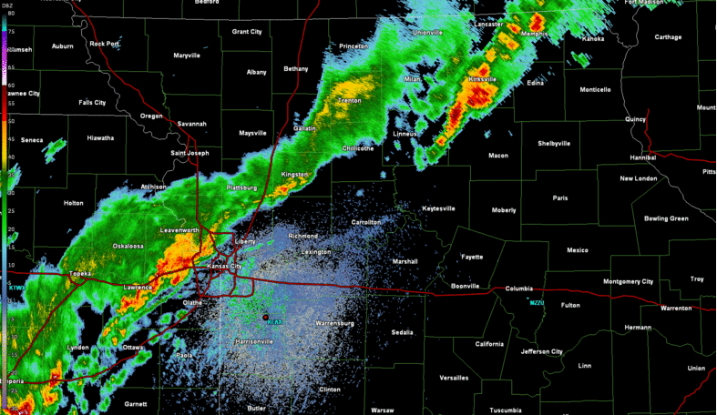 Radar loop of the storms forming near Kansas City, then evolving into several bowing segments that caused wind damage across western and central Missouri. |
Wind:
Several automated wind gauges across the area recorded 55 to 65 mph winds with the storms. The bulk of the damage across the area was done to trees, as several large trees were knocked over. Worlds of Fun theme park also experienced some wind damage as its displays were knocked over and a hotel sign came crashing down across the I-435 freeway.
 |
 |
.jpg) |
 |
|
A hotel sign was blown over, across from Worlds of Fun. Image: Alan Shope (KMBC)
@AlanKMBC
|
A T-Rex figure was blown over at Worlds of Fun when the strong winds came through that area. Image: Alan Shope (KMBC)
@AlanKMBC
|
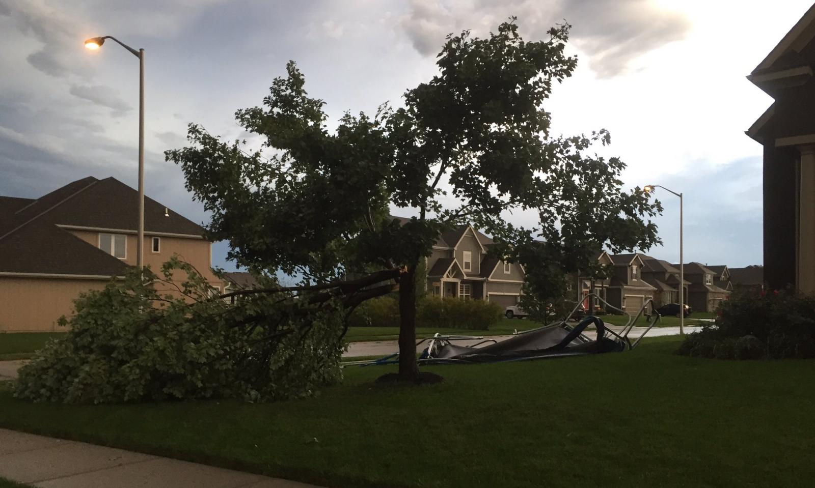
Strong winds cause numerous trees to topple over across northern Kansas City. Image: THE Fake Ned
@thefakened
|
Tree damage was a fairly common site across Kansas City after the strong winds moved through KC. Image: Kim Runk
@KimRunk
|
Storm Reports
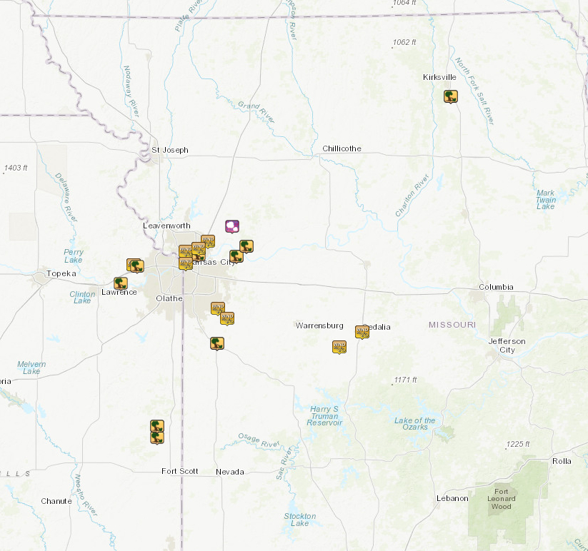
Map of severe weather reports from October 14, 2017. Click on the map for an interactive display.
..TIME...   ...EVENT...      ...CITY LOCATION...     ...LAT.LON...
..DATE...   ....MAG....      ..COUNTY LOCATION..ST.. ...SOURCE....
            ..REMARKS..

0903 PM     TSTM WND GST     1 NNE SEDALIA           38.71N 93.23W
10/14/2017  M58 MPH          PETTIS             MO   AWOS


0903 PM     TSTM WND GST     SEDALIA                 38.71N 93.23W
10/14/2017  M58 MPH          PETTIS             MO   AWOS


0850 PM     TSTM WND GST     GREEN RIDGE             38.62N 93.41W
10/14/2017  E65 MPH          PETTIS             MO   PUBLIC


0850 PM     TSTM WND GST     GREEN RIDGE             38.62N 93.41W
10/14/2017  E65 MPH          PETTIS             MO   PUBLIC


0728 PM     TSTM WND DMG     1 E MOUND CITY          38.14N 94.81W
10/14/2017                   LINN               KS   TRAINED SPOTTER

            SHINGLES BLOWN OFF ROOF. ALSO REPORTED
            MULTIPLE POWER OUTAGES ACROSS LINN COUNTY.

0728 PM     TSTM WND DMG     1 ESE MOUND CITY        38.14N 94.81W
10/14/2017                   LINN               KS   TRAINED SPOTTER

            SHINGLES BLOWN OFF ROOF. ALSO REPORTED
            MULTIPLE POWER OUTAGES ACROSS LINN COUNTY.

0726 PM     TSTM WND DMG     5 S MOUND CITY          38.07N 94.81W
10/14/2017                   LINN               KS   TRAINED SPOTTER

            MULTIPLE TREES DOWN AT 300 RD AND K-7
            HIGHWAY. TIME ESTIMATED TO RADAR.

0726 PM     TSTM WND DMG     5 S MOUND CITY          38.07N 94.81W
10/14/2017                   LINN               KS   TRAINED SPOTTER

            MULTIPLE TREES DOWN AT 300 RD AND K-7
            HIGHWAY. TIME ESTIMATED TO RADAR.

0621 PM     TSTM WND DMG     1 S HARRISONVILLE       38.64N 94.35W
10/14/2017                   CASS               MO   PUBLIC

            DELAYED REPORT...TREES DOWN AND DEBRIS IN
            ROAD SOUTH OF HARRISONVILLE. REPORT VIA
            SOCIAL MEDIA. TIME ESTIMATED TO RADAR.

0621 PM     TSTM WND DMG     1 SSW HARRISONVILLE     38.64N 94.35W
10/14/2017                   CASS               MO   PUBLIC

            DELAYED REPORT...TREES DOWN AND DEBRIS IN
            ROAD SOUTH OF HARRISONVILLE. REPORT VIA
            SOCIAL MEDIA. TIME ESTIMATED TO RADAR.

0620 PM     TSTM WND GST     PLEASANT HILL           38.79N 94.27W
10/14/2017  E60 MPH          CASS               MO   NWS EMPLOYEE


0620 PM     TSTM WND GST     PLEASANT HILL           38.79N 94.27W
10/14/2017  E60 MPH          CASS               MO   NWS EMPLOYEE


0618 PM     TSTM WND DMG     ORRICK                  39.22N 94.12W
10/14/2017                   RAY                MO   BROADCAST MEDIA

            DELAYED REPORT. ROOF DAMAGE TO HOUSE IN
            ORRICK. TIME ESTIMATED TO RADAR.

0618 PM     TSTM WND DMG     1 NNE ORRICK            39.22N 94.12W
10/14/2017                   RAY                MO   BROADCAST MEDIA

            DELAYED REPORT. ROOF DAMAGE TO HOUSE IN
            ORRICK. TIME ESTIMATED TO RADAR.

0613 PM     TSTM WND GST     GREENWOOD               38.85N 94.34W
10/14/2017  E65 MPH          JACKSON            MO   NWS EMPLOYEE


0613 PM     TSTM WND GST     GREENWOOD               38.85N 94.34W
10/14/2017  E65 MPH          JACKSON            MO   NWS EMPLOYEE


0540 PM     TSTM WND GST     CLAYCOMO                39.21N 94.49W
10/14/2017  E60 MPH          CLAY               MO   NWS EMPLOYEE


0540 PM     TSTM WND GST     1 NNE CLAYCOMO          39.21N 94.49W
10/14/2017  E60 MPH          CLAY               MO   NWS EMPLOYEE


0535 PM     HAIL             EXCELSIOR SPRINGS       39.34N 94.23W
10/14/2017  E0.88 INCH       CLAY               MO   PUBLIC


0535 PM     HAIL             EXCELSIOR SPRINGS       39.34N 94.23W
10/14/2017  E0.88 INCH       CLAY               MO   PUBLIC


0531 PM     TSTM WND GST     KANSAS CITY DOWNTOWN    39.12N 94.59W
10/14/2017  M65 MPH          CLAY               MO   ASOS

            LARGE TREE ALSO DOWN ON THE 2600 BLOCK OF
            SWIFT ST...REPORTED VIA SOCIAL MEDIA.

0531 PM     TSTM WND GST     KANSAS CITY DOWNTOWN    39.12N 94.59W
10/14/2017  M65 MPH          CLAY               MO   ASOS

            LARGE TREE ALSO DOWN ON THE 2600 BLOCK OF
            SWIFT ST...REPORTED VIA SOCIAL MEDIA.

0531 PM     TSTM WND GST     KANSAS CITY DOWNTOWN    39.12N 94.59W
10/14/2017  M65 MPH          CLAY               MO   ASOS


0529 PM     TSTM WND DMG     1 SSW SIBLEY            39.16N 94.20W
10/14/2017                   JACKSON            MO   PUBLIC

            DELAYED REPORT...MULTIPLE TREES DOWN ON
            ROADWAYS. RELOCATED A FULL 110 GALLON WATER
            TANK A SIGNIFICANT DISTANCE FROM ORIGINAL
            LOCATION. REPORT VIA SOCIAL MEDIA.

0529 PM     TSTM WND DMG     1 S SIBLEY              39.16N 94.20W
10/14/2017                   JACKSON            MO   PUBLIC

            DELAYED REPORT...MULTIPLE TREES DOWN ON
            ROADWAYS. RELOCATED A FULL 110 GALLON WATER
            TANK A SIGNIFICANT DISTANCE FROM ORIGINAL
            LOCATION. REPORT VIA SOCIAL MEDIA.

0526 PM     TSTM WND DMG     3 SSW BASEHOR           39.10N 94.96W
10/14/2017                   LEAVENWORTH        KS   EMERGENCY MNGR

            LARGE TREE DOWN AT 166TH AND EVANS RD. 20
            INCHES IN DIAMETER.

0526 PM     TSTM WND DMG     3 SSW BASEHOR           39.10N 94.96W
10/14/2017                   LEAVENWORTH        KS   EMERGENCY MNGR

            LARGE TREE DOWN AT 166TH AND EVANS RD. 20
            INCHES IN DIAMETER.

0515 PM     TSTM WND GST     NORTHMOOR               39.19N 94.59W
10/14/2017  E65 MPH          CLAY               MO   NWS EMPLOYEE

            DELAYED REPORT...REPORTED AT I-29 AND 69
            HIGHWAY.

0515 PM     TSTM WND GST     LIBERTY                 39.25N 94.42W
10/14/2017  E60 MPH          CLAY               MO   BROADCAST MEDIA


0515 PM     TSTM WND GST     LIBERTY                 39.25N 94.42W
10/14/2017  E60 MPH          CLAY               MO   BROADCAST MEDIA


0515 PM     TSTM WND GST     NORTHMOOR               39.19N 94.59W
10/14/2017  E65 MPH          CLAY               MO   NWS EMPLOYEE

            DELAYED REPORT...REPORTED AT I-29 AND 69
            HIGHWAY.

0511 PM     TSTM WND DMG     1 N RANDOLPH            39.17N 94.49W
10/14/2017                   CLAY               MO   PUBLIC

            DELAYED REPORT...12 INCH BRANCH DOWN AT
            WORLDS OF FUN. REPORTED VIA SOCIAL MEDIA.
            TIME ESTIMATED TO RADAR.

0511 PM     TSTM WND DMG     1 NNW RANDOLPH          39.17N 94.50W
10/14/2017                   CLAY               MO   BROADCAST MEDIA

            THE SIGN OF A FAIRFIELD INN ACROSS FROM
            WORLDS OF FUN WAS BLOWN OVER. PHOTOS CAME TO
            OUR OFFICE VIA TWITTER.

0511 PM     TSTM WND DMG     1 N RANDOLPH            39.17N 94.49W
10/14/2017                   CLAY               MO   PUBLIC

            DELAYED REPORT...12 INCH BRANCH DOWN AT
            WORLDS OF FUN. REPORTED VIA SOCIAL MEDIA.
            TIME ESTIMATED TO RADAR.

0446 PM     TSTM WND DMG     3 W LINWOOD             39.00N 95.09W
10/14/2017                   LEAVENWORTH        KS   PUBLIC

            POWERPOLES DOWN.

0446 PM     TSTM WND DMG     3 W LINWOOD             39.00N 95.09W
10/14/2017                   LEAVENWORTH        KS   PUBLIC

            POWERPOLES DOWN.

0443 PM     TSTM WND GST     4 SW BASEHOR            39.11N 94.99W
10/14/2017  M58 MPH          LEAVENWORTH        KS   TRAINED SPOTTER


0443 PM     TSTM WND GST     3 SW BASEHOR            39.11N 94.99W
10/14/2017  M58 MPH          LEAVENWORTH        KS   TRAINED SPOTTER


0436 PM     TSTM WND DMG     MILLARD                 40.11N 92.55W
10/14/2017                   ADAIR              MO   911 CALL CENTER

            POWER LINES DOWN AND ROOF BLOWN OFF HOME IN
            MILLARD.

0436 PM     TSTM WND DMG     MILLARD                 40.11N 92.55W
10/14/2017                   ADAIR              MO   911 CALL CENTER

            POWER LINES DOWN AND ROOF BLOWN OFF HOME IN
            MILLARD.

0436 PM     TSTM WND DMG     MILLARD                 40.11N 92.55W
10/14/2017                   ADAIR              MO   911 CALL CENTER

            POWER LINES DOWN IN MILLARD.
 |
Media use of NWS Web News Stories is encouraged! Please acknowledge the NWS as the source of any news information accessed from this site. |
|


 Weather Story
 Weather Map
 Local Radar