
Numerous severe thunderstorms are expected across a broad region from the Ohio Valley to the Mid-Atlantic and Northeast States today into tonight. Swaths of damaging wind gusts are expected and some tornadoes are possible. Bertha is expected to bring tropical storm conditions to portions of the Gulf Coast from the Florida Panhandle westward to southeastern Louisiana later today and Wednesday. Read More >
Since 1950, more than 300 tornadoes have been reported in the area now served by the National Weather Service Forecast Office in Pleasant Hill. The majority of tornadoes have been classified as weak to moderate tornadoes, the most common types of tornadoes to affect all parts of the United States. On rare occasions, less than 20 percent based on official records, the Kansas City area and the surrounding area has experienced significant tornadoes. The most destructive and deadly of these tornadoes occurred on the evening of May 20, 1957. The tornado event of May 20, 1957 thereafter earned the local moniker of the Ruskin Heights tornado due to the extreme devastation and loss of life that occurred in this Kansas City neighborhood.
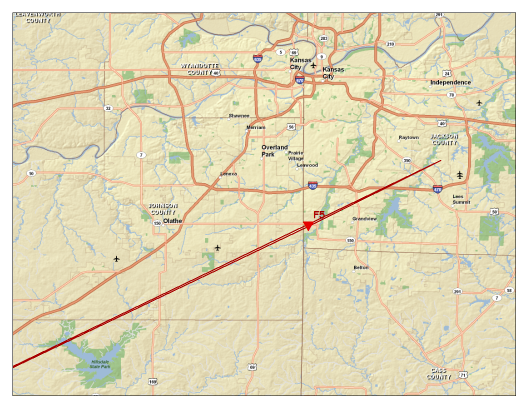
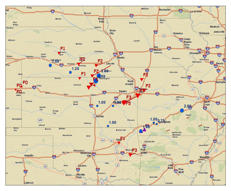
Though labeled the Ruskin Heights tornado, the tornado actually began its 71 mile path near Williamsburg, Kansas at 6:15 pm LST. Below is an image taken from the cover of the official damage report of the "Kansas-Missouri" tornado. Though post-mortems of major tornado events are common today, only two damage reports were conducted for tornadoes in 1957, one of them for "Kansas-Missouri" or Ruskin Heights tornado. The tornado earned the most extreme damage rating of that time, F5, as it carved a path ranging from one-tenth to nearly one-half mile wide (700 yards) sped northeast at approximately 42 miles per hour. The Ruskin Heights tornado was one of thirty-five confirmed tornadoes that impacted areas of Colorado, Kansas, Nebraska, Oklahoma and Missouri on May 20, 1957, including a devastating tornado accompanied by hail seven inches in diameter that struck Concordia, Kansas. The spotter network that in the present day provides such valuable information to the National Weather Service was not in place in 1957, explaining the sparsity of hail and damaging wind reports displayed in the graphic report.
 |
 |
| Click on image to view larger size | Click on image to view larger size |
| Figure 1. Damage track of tornado | Figure 2. Regional Storm Reports from 05/20/1957. Tornadoes denoted by red triangles and labeled by "F" scale. Hail reports denoted by blue circles and labeled by hail size. |
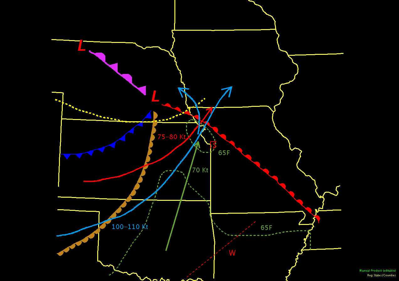
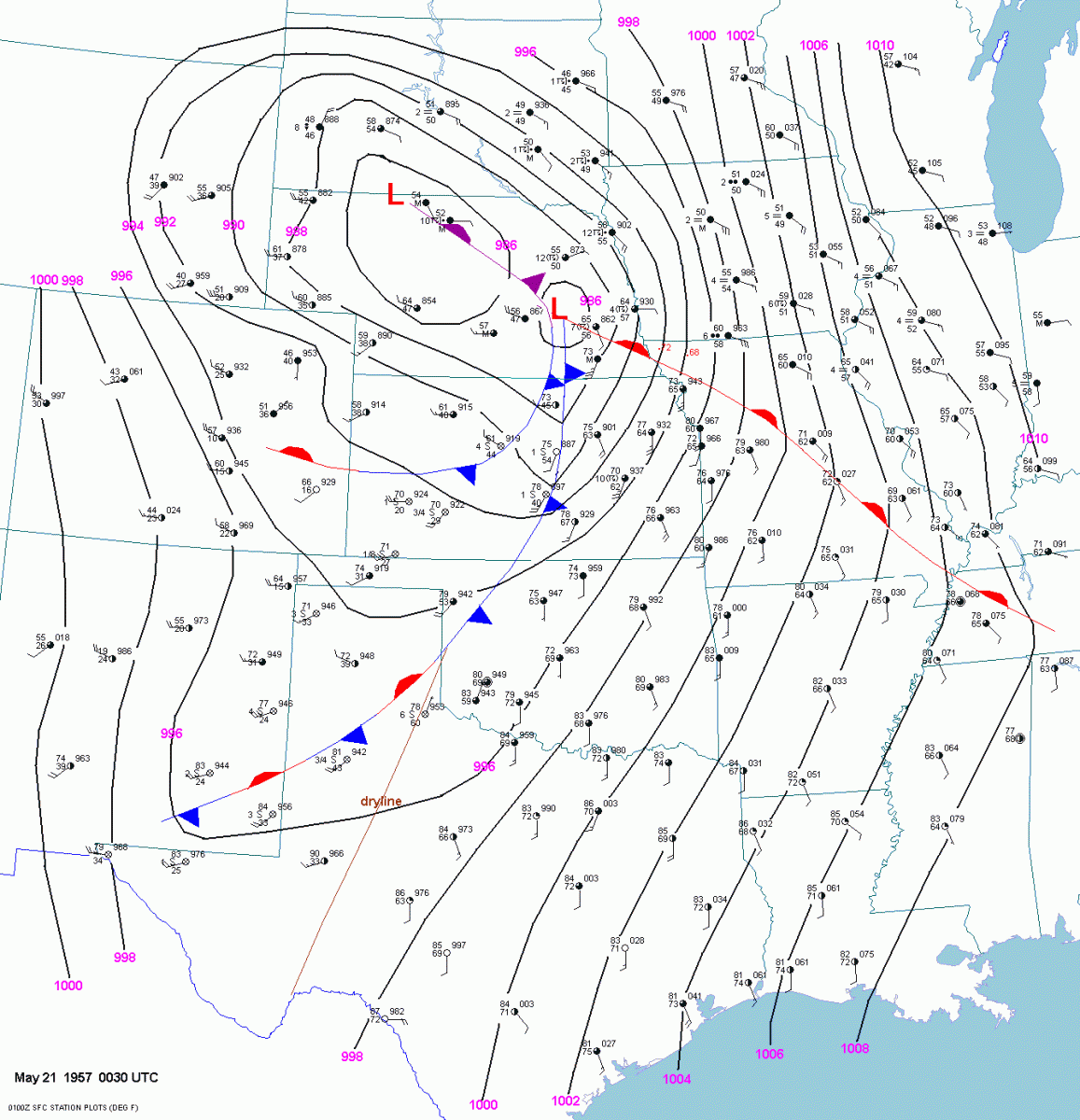
The meteorological conditions present on May 20, 1957 were prime for severe thunderstorm development, namely supercell thunderstorm development. The graphics below depict a composite of the surface and upper level conditions that existed prior to the development of the Ruskin Heights tornado. Key ingredients included a progressive upper level storm system that focused the jet axes at 850 mb (green), 500 mb (red) and 300 mb (light blue) over Kansas City (Figure 3) and a well-developed surface frontal system, with a low centered over south central Nebraska (Figure 4). The interaction of these features helped to provide a focus for thunderstorms to develop intially across northeast Colorado, with the first tornado of the day touching down around 11:00 am LST in Kit Carson, County and tracking north of Goodland, Kansas. Tornadoes and severe thunderstorms spread across Nebraska and Kansas during the afternoon hours on 5/20/1957. As the frontal system moved eastward across the plains, a steady influx of low level moisture from the Gulf of America provided the fuel for continued thunderstorm development into the nighttime hours of 5/20/1957 across northeast Oklahoma, northeast Kansas and northwest Missouri. By 11:00 pm LST, the threat of severe weather had subsided in the region, but 5/20/1957 would go down in the record books. In addition to the severe weather that occurred in Kansas City and the surrounding area on May 20th, severe weather was reported across the central plains and Midwest states on May 19th and May 21st as well. In fact, the period of May 19-26, 1957 would be recognized as one of the most active period of tornado occurrence, in the newly formed U.S. Weather Bureau's existence. At week's end, the U.S. Weather Bureau logged the highest one-day tornado count ever recorded in the United States on 5/20/1957: 50 twisters whirled across the central Plains and Midwest (Time Magazine, 6/3/1957).
 |
 |
| Click on image to view larger size | Click on image to view larger size |
| Figure 3. Composite map depicting surface and upper air conditions prior to Ruskin Heights tornado event. | Figure 4. Surface chart depicting observations and frontal position at 6:30 pm LST 05/20/1957. Courtesy of Jonathan Finch, NWS Dodge City, Kansas. |
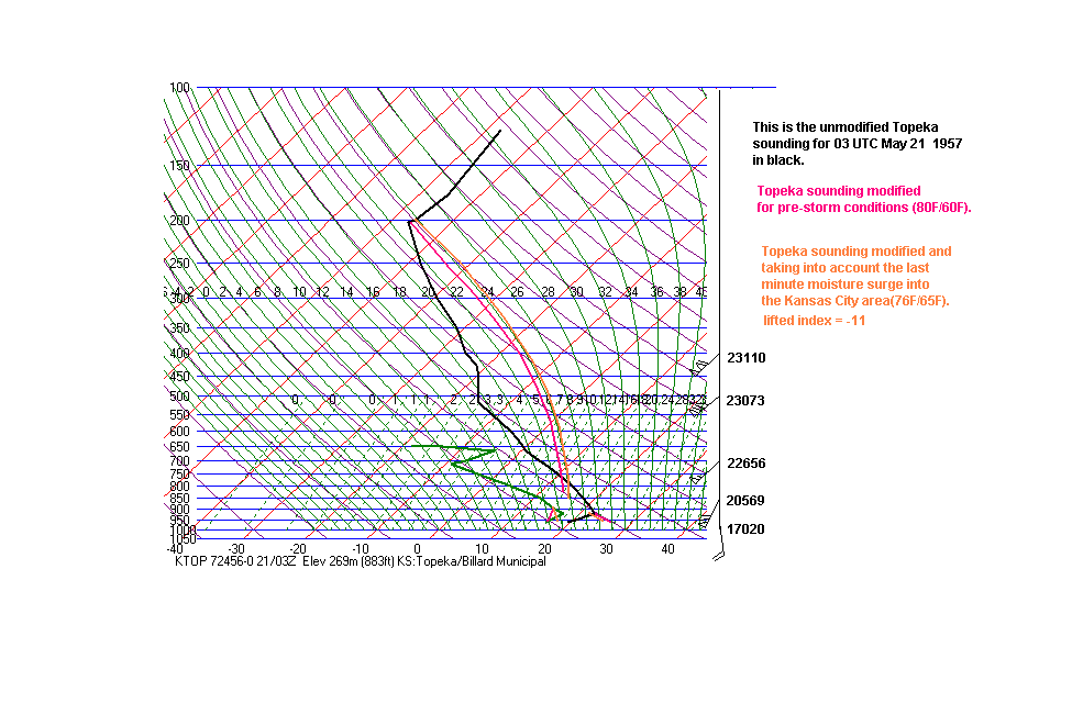
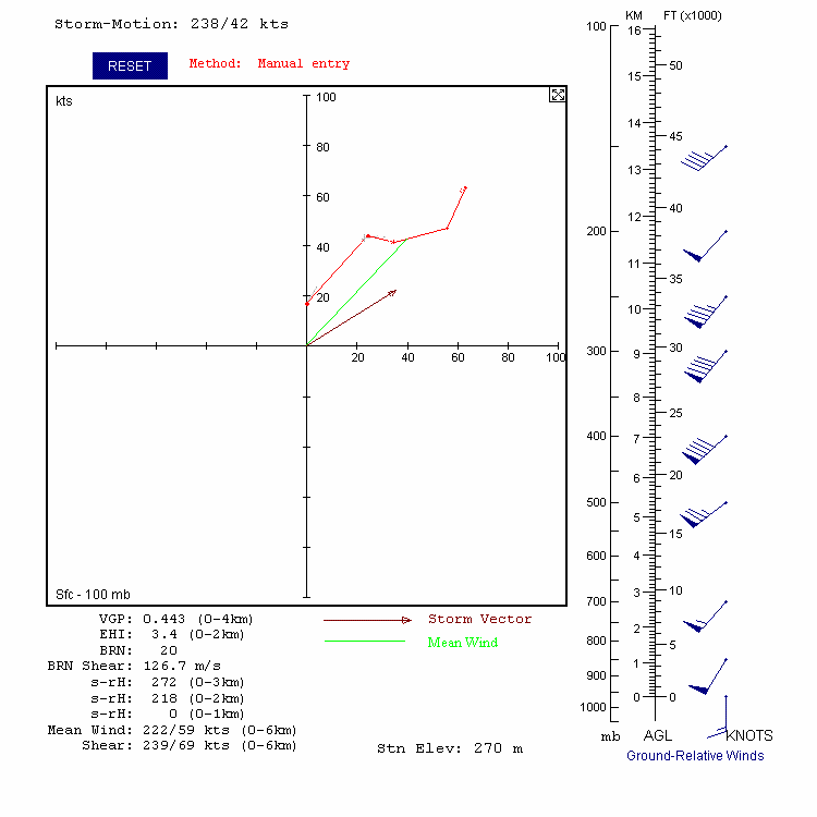
The upper air sounding network that meteorologist rely upon to assess the instability and wind shear in the atmosphere was not as dense in 1957 as it is today. In the local area, atmospheric soundings were taken at Topeka, Kansas and Columbia, Missouri. Routine soundings of the atmosphere were taken at 9:00 am LST and 9:00 pm LST, with soundings taken as needed at 3:00 am LST and 3:00 pm LST. The Topeka, Kansas sounding taken at 9:00 pm LST is shown below (Figure 5), the launch occurring shortly after the tornado struck. Meteorologists assess the instability of the atmosphere by analyzing the thermal profile of temperature and moisture, depicting in black and green respectively, through the depth of the atmosphere. The red and orange curves to the right of the temperature profile provide meteorologists with an idea of the convective available potential energy (CAPE) in the atmosphere. In this instance, the chart is depicting about 3000 J/kg (Joules per kilogram) of energy that can be tapped. In general, meteorologists look for CAPE values in excess of 1000 J/kg when forecasting severe storm development. Atmospheric vertical wind shear controls the organization of thunderstorm development. To assess the wind shear of the atmosphere, meteorologists inspect the wind profile through the depth of the atmosphere. On May 20, 1957 the atmospheric wind profile displayed a clockwise change in wind direction from the surface up through 30,000 feet in the atmosphere. This type of atmospheric wind profile often is associated with rotating or supercell type thunderstorms (Figure 6).
 |
 |
| Click on image to view larger size | Click on image to view larger size |
| Figure 5. Atmospheric sounding taken from Billard Airport in Topeka, Kansas at 9:00 pm LST, shortly after Ruskin Heights tornado. Courtesy of Jonathan Finch, NWS Dodge City, Kansas. | Figure 6. Hodograph depicting atmospheric wind shear prior to Ruskin Heights tornado. Hodograph derived from surface observations in Kansas City and from atmospheric sounding taken from Topeka, Kansas. Courtesy of Jonathan Finch, NWS Dodge City, Kansas. |
The severe watch and warning program in place today's National Weather Service was not in existence in 1957. Hazardous weather forecasts and warnings were issued by district forecast centers, while radar surveillance was performed at local observing sites. In 1957, the local weather and radar observation office in Kansas City was located at Kansas City Municipal Airport (Charles Wheeler), whereas the district forecast office recently had moved to the Federal Building located at 911 Walnut. Co-located with the district weather forecast office was the Severe Local Storms Unit (SELS), which had transferred to Kansas City in 1954, and the Aviation Forecast Unit.
The use of radar to detect weather phenomena was a new technology during the 1950s. The radar network in place during the 1950s was composed of a hodge podge of excess military radars that were used during World War II. The U.S. Weather Bureau had installed a new radar (WSR-57, 10 cm) on top of the Federal Building several months prior to the Ruskin Heights tornado; however, the radar was not operational on that fateful day. The radar operator at the Kansas City Municipal Airport on May 20, 1957, Mr. Joseph Audsley, performed radar surveillance using an older radar (WSR-1, 10 cm). Communication between local weather office and SELS was accomplished by teletype. In addition, teletype was used to disseminate weather-related information to the media. The following is a transcript of U.S. Weather Bureau teletype messages issued on May 20, 1957. The transcript is supplemented with additional information chronicled by Joseph Audsely, as well as, Allen Pearson and Hugh G. Crowther formerly of SELS. You will note that the terms "tornado warning" and "severe thunderstorm warning" are not included in this transcript, as these terms were not part of the U.S. Weather Bureau lexicon at the time.
May 20, 1957 - 11:00 am LST
Severe Weather Forecast #167 issued by Severe Local Storms Forecast Unit that highlighted the threat of severe weather, including tornadoes, for a large area that encompassed the Kansas City area.
 |
| Click on image to view larger size |
| Figure 7. Severe Weather Watches and Initial Tornado reports from 05/20/1957. Courtesy of "A Kansas City Area Guide to Severe Thunderstorms and Tornadoes" by Charles Doswell & Fred Ostby, August 1982. |
May 20, 1957 - 1:30 pm LST
Severe Weather Forecast #167 updated by Severe Local Storms Forecast Unit.
May 20, 1957 - 3:28 pm LST
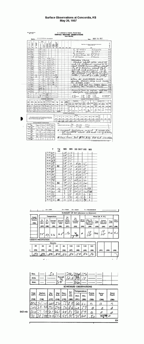
The Weather Bureau Office in Concordia, Kansas reported a tornado six (6) to seven (7) miles southeast of the office (Figure 2 and Figure 7).
 |
| Click to view larger image |
| Figure 8. Surface observations taken at the U.S. Weather Bureau office located in Concordia, Kansas on May 20, 1957. |
May 20, 1957 - 4:30 pm LST
Severe Local Storms Units consolidated Severe Weather Forecast #167 and #168 into a new forecast area - Severe Weather Forecast #169. Severe Weather Forecast #169 called for "Scattered severe thunderstorms and several tornados (sic) for the rest of the afternoon and until 9:00 P.M. this evening. This area is bounded by a line from 40 miles north of Grand Island, Nebraska, to Salina, Kansas, to 30 miles west-northwest of Wichita Falls, Texas to McAlester, Oklahoma to Joplin, Missouri to 50 miles southeast of St. Joseph, Missouri to 20 miles west of Des Moines, Iowa to 40 Miles north of Grand Island, Nebraska."
May 20, 1957 - 5:06 pm LST
Update to Severe Weather Forecast #169
"Over Kansas and Missouri this afternoon the weather ranges from heavy thunderstorms activity to dry, windy and dusty. Strong southerly winds over much of the area have brought moisture to some sections and causing blowing dust over vast portions of Kansas. There have been numerous tornados in Kansas and up in Nebraska. The latest radar report from Kansas City shows an area of thunderstorm activity about 60 to 70 miles north and another area about 100 miles southwest.
Forecast calls for: Thunderstorms over east sections of Oklahoma and Kansas and across Nebraska, Iowa and Missouri. Thunderstorms may be heavy tonight in southeast Nebraska, southwestern Iowa, extreme northwest Missouri, eastern Kansas, central and northeast Oklahoma. Temperatures will stay mild tonight over Missouri with cooler weather in store for southwest Kansas and western Oklahoma."
May 20, 1957 - 5:30 pm LST
Update to Severe Weather Forecast #169
"A severe thunderstorm at Emporia, Kansas was giving hail up to 1 inch in diameter radar at the Kansas City weather bureau showed the storm to be very severe and moving northeastward in the general direction of Kansas City at about 50 miles per hour. This storm will be kept under close surveyance by weather bureau radar and any changes in it's course and it's intensity will be reported at once on this circuit. For the present it appears that Kansas City may expect high winds, accompanied by hail by 8:00 P.M. this evening or shortly before. 6:00 P.M. temperature 80."
May 20, 1957 - 6:05 pm LST
"The severe thunderstorm mentioned at 5:30 P.M. at Emporia, Kansas is now centered 55 miles southwest of Kansas City and continues to move in this direction. It is now several separate cells and is still severe. Further advice follows:
The center of the storm is just southeast of Baldwin City and is approaching that city.
Cooperative observer at Marysville, Missouri reports two tornadoes in the vicinity of Marysville between 4:00 and 6:00 P.M. this afternoon. Neither storm did any damage."
May 20, 1957 - 6:15 pm LST
Tornado that would go on to ravage Ruskin Heights touches down two miles southwest of Williamsburg, Kansas. As the tornado moved northeast through farmland north and east of Williamsburg, it brushed the town of Homewood, Kansas. Around Homewood, witnesses reported multiple funnels, the main one of which caused massive damage beginning at the Antioch Cemetery northeast of Homewood. Head stones from the cemetery were carried for miles. One eyewitness recalled seeing a greenish-gray cloud turning violently. "Tentacles were reaching down out of the cloud and bouncing off the ground," one eyewitness recalled. "Five and up to 10 tentacles came down and joined together."
Next the tornado skirted along the hill on the southern fringe of Ottawa, where it did the damage to the U-Rest Motel, Bob's Truck Stop, Hillcrest Drive-In and surrounding area. Ten guests were registered at the motel, and operators Mr. and Mrs. Glenn Geiss took them into their home and into the basement, while the owner of the restaurant gathered his patrons into a station wagon and drove all of them safely to the south. (Ottawa Herald, 5/20/2000)
The first two victims of the tornado were reported about two and one half miles east of Ottawa when the tornado slammed into the home of an elderly couple just sitting down to dinner. The twister lifted up the house and demolished it. .
May 20, 1957 - 6:30 pm LST
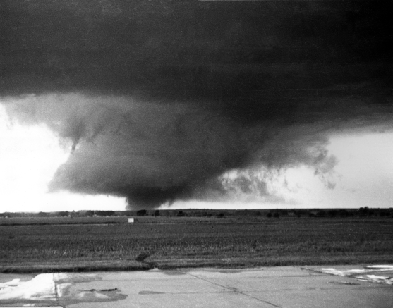
"A funnel cloud touching the ground was sighted 40 miles Southwest of Kansas City moving northeastward."
 |
 |
| Click on image to view larger size | Click on image to view larger size |
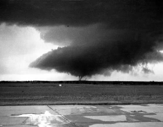
| Figure 9. Photo of tornado taken from the airport near Ottawa, Kansas at approximately 6:30 pm LST. Tornado is display mulit-vortex characteristics. Photo courtesy of Dr. Charles Doswell, CIMMS/University of Oklahoma. Photographed by Charles LeMaster. | Figure 10. Another photo of the tornado taken from the airport near Ottawa, Kansas. Photographer is facing north. Photo courtesy of Dr. Charles Doswell, CIMMS/University of Oklahoma. Photographed by Charles LeMaster. |
May 20, 1957 - 6:52 pm LST
"Another funnel cloud was sighted in the vicinity of Paola, Kansas moving rapidly northward.
The forecast for Kansas City calls for thunderstorms, possibly severe with a chance of a tornado in the greater Kansas City area. A tornado has been reported at Rantoul, Kansas, heading for Lawrence, Kansas. A tornado reported at Spring Hill, about 20 miles south-southwest of Kansas City."
 |
| Click on image to view larger size |
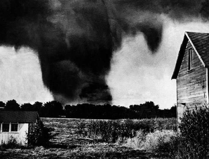
| Figure 11. Tornado near Spring Hill, Kansas. Original photograph taken from the north porch of the parsonage of the Methodist Church. Photographer looking north. Photograph has been cosmetically enhanced. As the storm strikes the small town of Spring Hill, Kansas, four members of the Isham Davis family were killed. Photo courtesy of Tim Janicke, Kansas City Star. Photographed by Reverend Robert Alexander. |
C
May 20, 1957 - 7:15 pm LST
"Radar shows the largest thunderstorm cell from the southwest portion of Kansas City, southwestward to the vicinity of Olathe. There have been numerous unconfirmed reports of tornadoes from this massive storm when it was in the vicinity of Paola and Ottawa, Kansas - it is still a potent storm and will bear watching as it moves northeastward over greater Kansas City."
May 20, 1957 - 7:23 pm LST
"Radar at the airport shows an echo which appears to be very severe just 3 or 4 miles southeast of Olathe, Kansas, moving northeastward.
We have just this moment received report of a tornado on the ground moving rapidly northeastward at this exact spot."
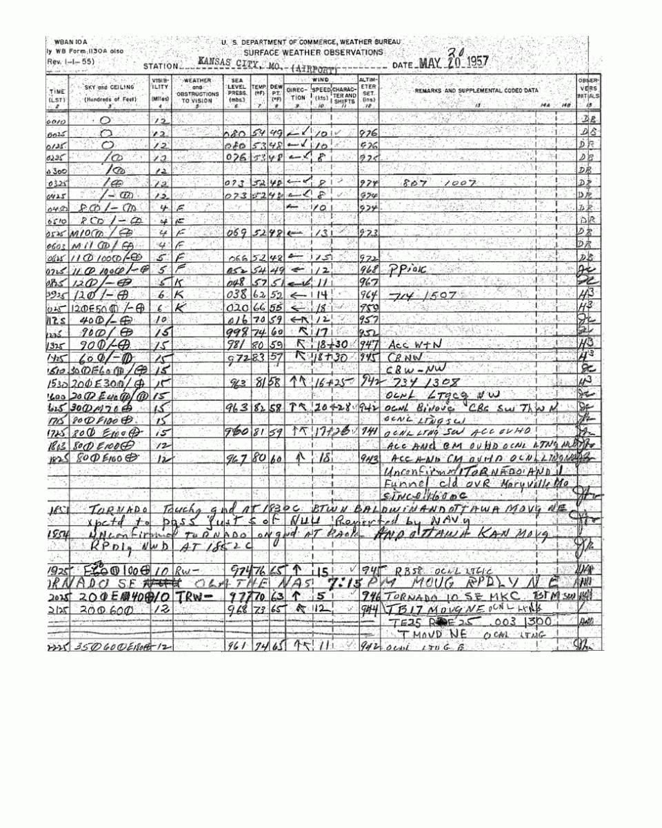
Figure 12. Surface observations taken at the U.S. Weather Bureau office
at the Kansas City Municipal Airport on May 20, 1957.
May 20, 1957 - 7:37 pm LST
"Airline pilot reports funnel cloud 2 miles west of Grandview Airport."
The tornado crosses the Missouri-Kansas state line striking the Martin City area. Twenty-three boys housed at the Ozanam's Boy's home were spared by seeking refuge in the basement. Forty or more celebrants attending a birthday party at a Methodist Church located 135th and Holmes, the current location of the Martin City Melodrama and Vaudeville Company, also were spared by seeking shelter. Virtually every home and building in Martin City was damaged or destroyed, including the popular Jess and Jim's Steakhouse though the owner's parakeet remained unharmed. Unfortunately, by the time the tornado moved northeast of Martin City, 2 more people were dead and 35 were injured.
May 20, 1957 - 7:44 pm LST
"The most severe thunderstorm activity is now to the south and southeast of Greater Kansas City. A funnel has been observed about 2 miles north of Olathe Naval Air Station.
Reports indicate that the funnel observed 2 miles west of the Grandview Air Force Base was also observed from the ground at the Base. There are severe thunderstorms through the area and precautions should be taken by everyone.
Please report radio listeners not to call the Weather Bureau except to report wind storm damage or the sighting of a funnel cloud.
Half-inch hail and heavy rain at 71st and Woodland.
"Weather Warning issued by Weather Bureau Forecast Center, Kansas City, Missouri:"
May 20, 1957 - 7:45 pm LST
"Braniff pilot reports tornado on the ground north of Grandview moving northeast - appears to be headed toward East edge of city."
May 20, 1957 - 7:50 pm LST
"Tornado observed at Holmes Park. Funnel was reaching the ground. This was at 95th and Highway 71."
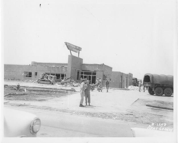
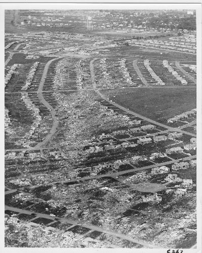
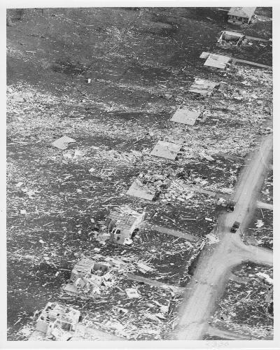
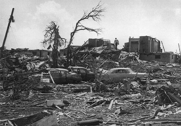
There were many square blocks of devastation in Hickman Mills and the Ruskin Heights area, in some places the ground was swept clean, while huge trees were toppled or snapped off. The Hickman Mills Bank at 107th and U.S. Highway 71 lost its south wall to the tornado and had to be protected by the National Guard. The Hickman Mills Furniture Company was demolished and the cars on both sides of U.S. Highway 71 were tossed about like toys.
The storm moved into Ruskin Heights, ripping through the shopping center at 111th and Blue Ridge Boulevard, heavily damaging Ruskin Heights High School and cutting through a thickly populated portion of Ruskin Heights. Because of warnings on radio and television, many Ruskin Heights residents were able to take refuge in their basements or with neighbors who had basements. At least fifty people took refuge in one basement, literally lying on top of each other, at East 110th street. The roof was blown off the home, yet no one was injured. Those that did not seek shelter with neighbors gathered family and friends in automobiles and drove out of the storm's path. Sadly, many people did not escape the tornado's fury and 37 lives were lost in the communities of Ruskin Heights and Hickman Mills.
May 20, 1957 - 7:53 pm LST
Tornado lifted, about two miles north of Knobtown, MIssouri. In it's wake, 44 people lost their life and 531 people were injured.
May 20, 1957 - 7:55 pm LST
"Funnel observed at 87th and Raytown."
May 20, 1957 - 7:57 pm LST
"A funnel observed just to the South of Raytown."
May 20, 1957 - 7:59 pm LST
"Yet another funnel reported in the Raytown area, or rather a third report of the funnel being sighted."
May 20, 1957 - 8:00 pm LST
"A report of the funnel being observed 2 miles West of Raytown. Last report from man at 39th and Tracy was tornado was about 3 miles northeast of Raytown."
May 20, 1957 - 8:10 pm LST
"To keep you up-to-date on severe weather in this area, the mass of thunderstorm which has apparently moved across the southern portion of the city in recent minutes, is now to the east of the city and this particular storm probably poses no further threat to the city. There are however, other strong thunderstorms from Lake Quivira southward to the Olathe, Springhill area. These latter are moving east-northeastward and precautions should be taken by all residents."
Several other forecast updates were made through 9:00 pm with an "all-clear" update issued at 9:00 pm for the greater Kansas City area.
May 20, 1957 - 9:00 pm LST
"The earlier severe thunderstorm which caused damage in some southeast portions of Greater Kansas City is now well to the northeast being well toward the Chillicothe area. There are now no radar echos toward the west-southwest or south of the Greater Kansas City area. Therefore a tentative all-clear is now issued and no further warnings will be issued until or if additional thunderstorm activity develops to the southwest.
The Weather Bureau appreciates the many calls that have been received reporting the sighting of funnel clouds or reporting wind damage.
Further the radio and television stations of the city have performed a service to everyone in carrying frequent bulletins to the one million people of the Greater Kansas City region."
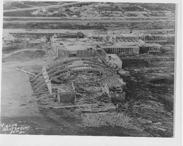
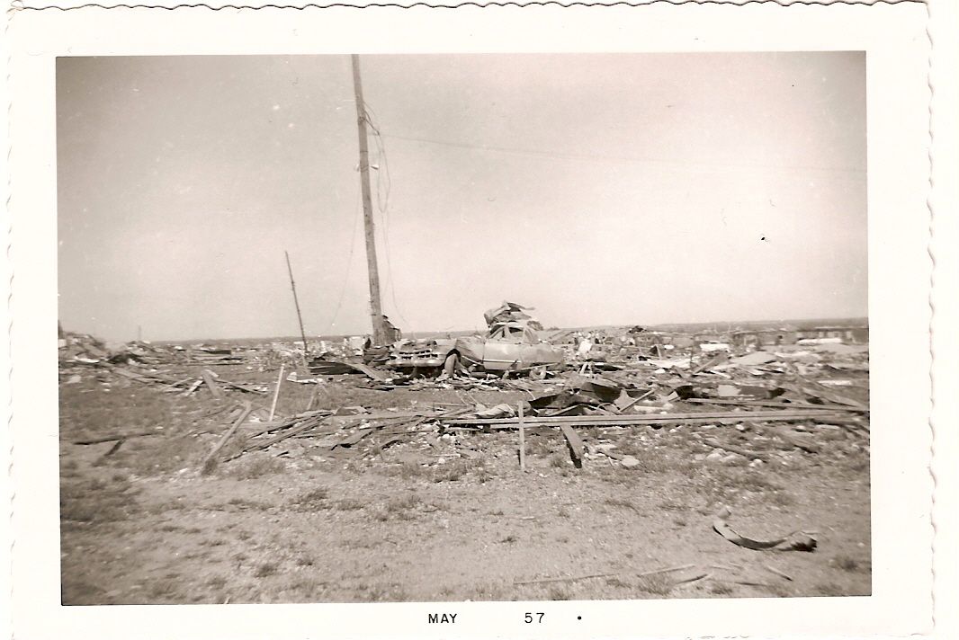
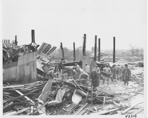
The tornado carved a continuous, seventy-one mile path of destruction from where it touched down near Williamsburg, Kansas until it lifted near Knobtown, MIssouri. The tornado ranged in width from 175 yards (one-tenth of a mile) to 700 yards (slightly less than one-half of a mile) and was on the ground for one hour and thirty-eight minutes. The human toll was significant, 44 people lost their lives, 7 in Kansas and 37 in Missouri, and 531 people were injured. Damage from the tornado was estimated at $2.5 million dollars. The destructive nature of the tornado can be seen in the numerous damage photos taken after the tornado struck.
 |
 |
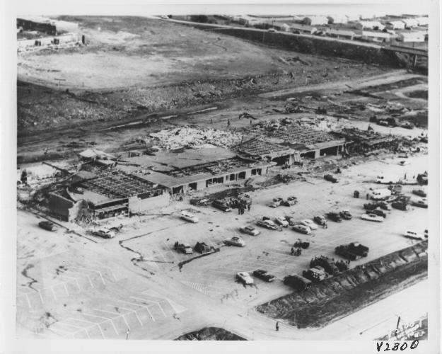 |
| Figure 13. Damage to Hickman Mills State Bank. Photo courtesy of Kansas City Star. | Figure 14. Damage to Ruskin Heights High School. Photo courtesy of Kansas City Star. | Figure 15. Damage to Ruskin Shopping Center.hoto courtesy of Kansas City Star. |
 |
 |
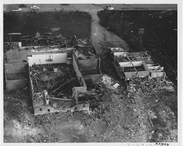 |
| Figure 16. Aerial shot of tornado path through Hickman Mills and Ruskin Heights. Courtesy of Kansas City Star. | Figure 17. Damage to homes. Courtesy of Kansas City Star. | Figure 18. Damage to Ruskin Junior High School. Courtesy of Kansas City Star. |
 |
 |
 |
| Figure 19. Damage to automobile. Photo courtesy of Joyce Rew (tornado survivor) | Figure 20. Damage to business. Photo courtesy of Kansas City Star. | Figure 21. Damage to home in Hickman Mills. Photo courtesy of Kansas City Times. |
Numerous individuals contributed to the development of this web page. Transcripts of the event from Mr. Joseph Audsley provided a first-hand account of the storm's evolution. Mr. Allen Pearson's and Mr. Hugh Crowther's narrative of the event provided information on the evolution of the storm and it's human toll. Carolyn Brewer, author of a book detailing the human impact of the storm, "Caught in the Path", provided information about several photographs used on this page. Mr. Tim Janicke of the Kansas City Star provided a historical perspective on the high-resolution image of the tornado near Spring Hill, Kansas. Dr. Charles Doswell provided two high resolution images of the tornado near Ottawa, Kansas. Mr. Jonathan Finch of the National Weather Service Forecast Office in Dodge City, Kansas deserves special recognition for his assistance in the development of the meteorological data analysis. A dog-earred copy of "A Kansas City Area Guide to Severe Thunderstorms and Tornadoes" by Dr. Charles Doswell and Mr. Fred Ostby, formerly of SELS, provided additional information about the meteorological state of the atmosphere on May 20, 1957. Finally, to the staff of the National Weather Service Forecast Office in Pleasant Hill for providing their assistance in developing this page.


 Weather Story
 Weather Map
 Local Radar