
A slow moving front will bring rounds of strong to severe thunderstorms and heavy rainfall to the central Plains eastward to the east-central U.S.. The first widespread significant heat wave of summer for the Intermountain West and Plains is expected to develop today and expand through next week. Dangerous heat will continue to impact portions of the Southwest and Southeast. Read More >
Overview
|
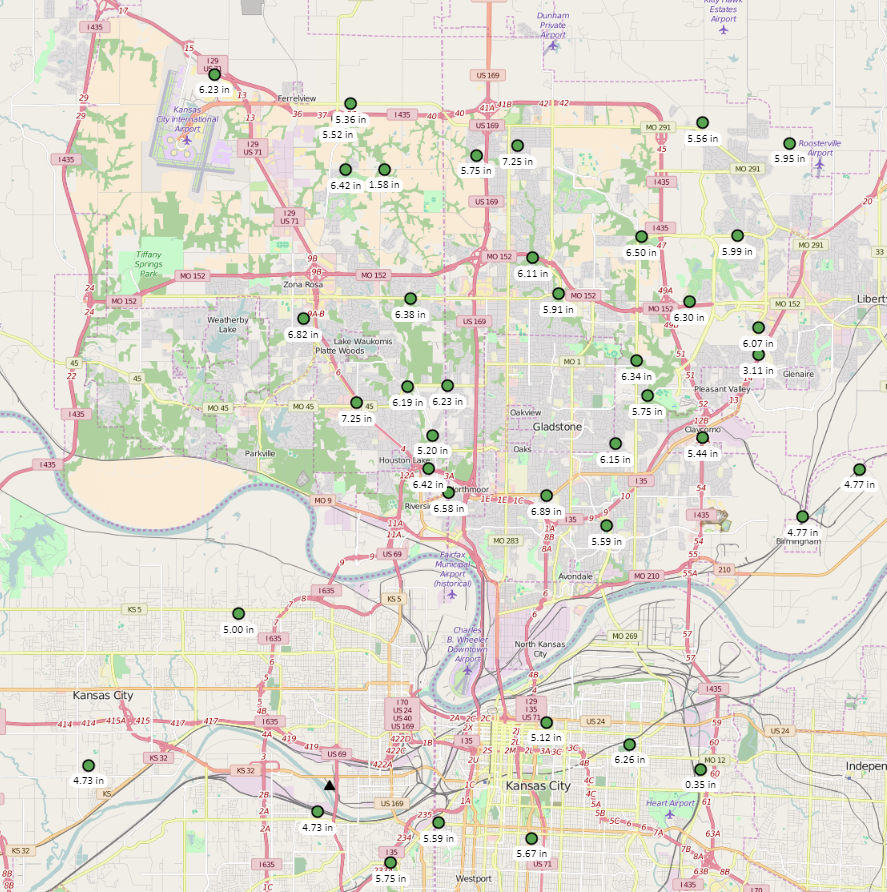
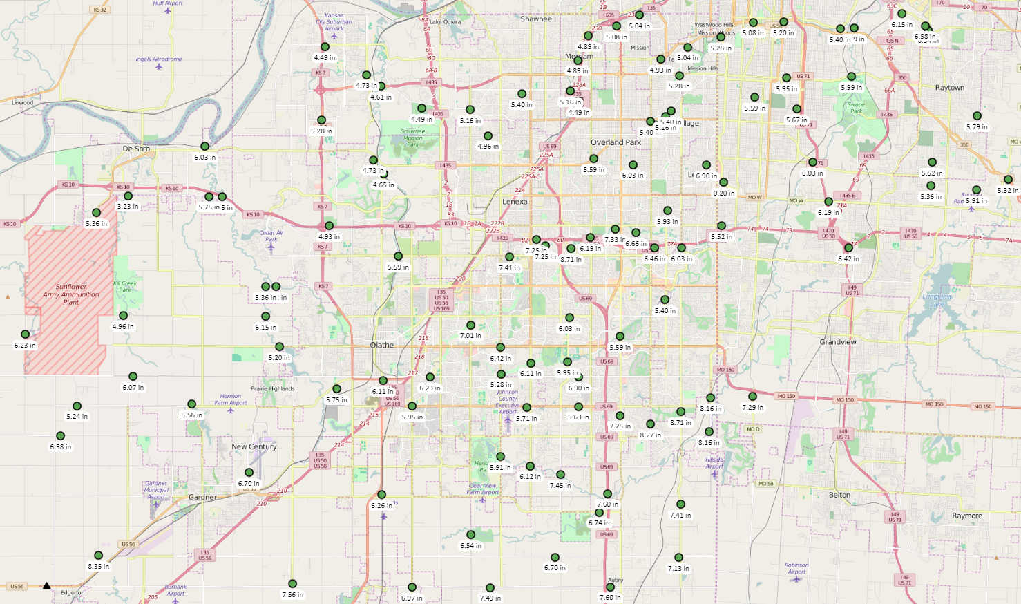
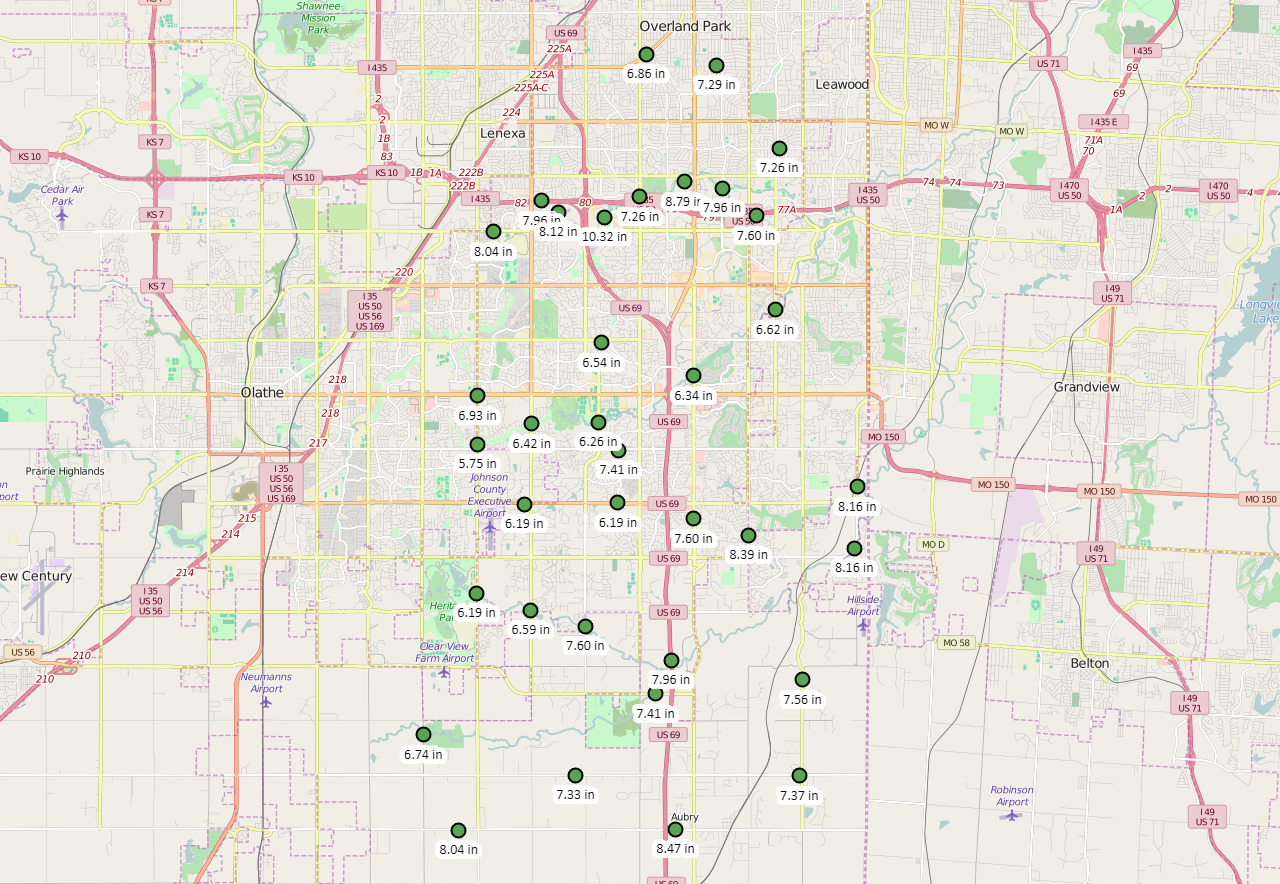
From August 21st through the 22nd, multiple rounds of heavy rain fell, with some of the highest totals observed over the southwestern portions of the Kansas City metro area and other locations south of Kansas City. Widespread amounts of 4" to 6" were recorded, with isolated reports of 8" to nearly 10". In addition to numerous roads and some schools closed due to widespread flooding, record crests were made on Indian Creek at State Line Road as well as in Overland Park. Several water rescues were made overnight Monday into Tuesday morning, with one fatality due to flooding. The fatality occurred on the east side of HWY 69 near 363rd St in Miami County, where deep rushing water was present. |
 Local Storm Reports Issued 21-22 August 2017 |
Flooding
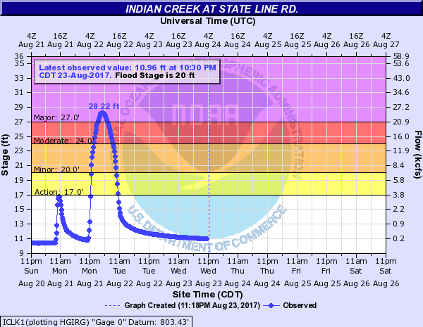
Over 60 water rescues took place across the Kansas City metro area, and at last count, 62 of those water rescues occurred overnight on the 21st into the 22nd in Kansas City, MO. Indian Creek at State Line Road broke the record that only stood for about 3 weeks, when it eclipsed the 28 foot mark for the first time in that location's recorded history, which goes back to 2004. This flooding was caused by a period of roughly 6 hours that produced 5 to 7 inches of rain, with some locations seeing 8 to nearly 10 inches.
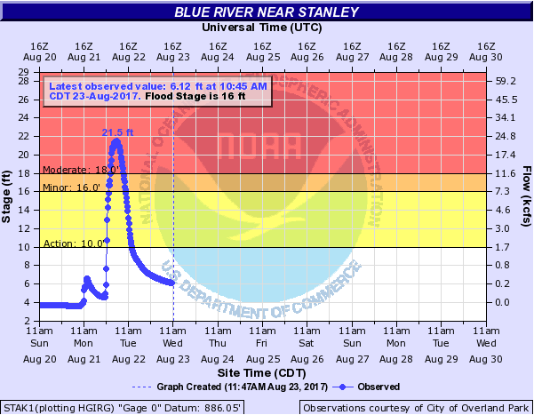
Hydrographs
 |
(1).png) |
 |
| Indian Creek at State Line Road Crested at 28.22 feet, surpassing the previous record of 27.96 feet, set recently on July 27th, 2017. |
Indian Creek in Overland Park Crested at 18.39 feet, surpassing the previous record of 17.97 feet, set recently on July 27th, 2017. |
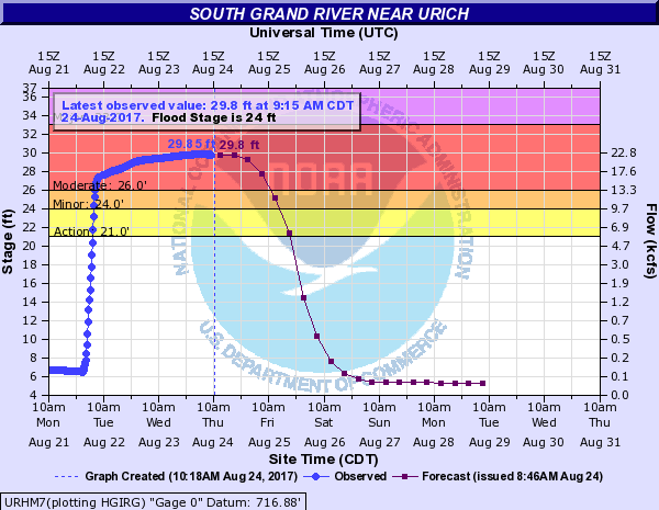
South Grand River near Urich As of 8/24/17, cresting near 29.85 feet, nearly reaching the record stage of 30.55 feet, set back on July 2nd, 2007. |
 |
 |
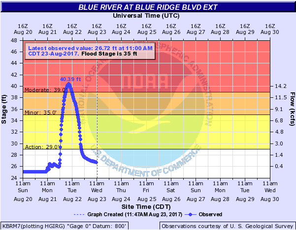
| Blue River at Blue Ridge Blvd Ext Crested at 40.39 feet, surpassing the second place record of 39.50 feet, set back on January 1st, 1958. |
Blue River near Stanley Crested at 21.5 feet, surpassing the previous record of 30.51 feet, set back on May 15th, 1990. |
Rainfall
 |
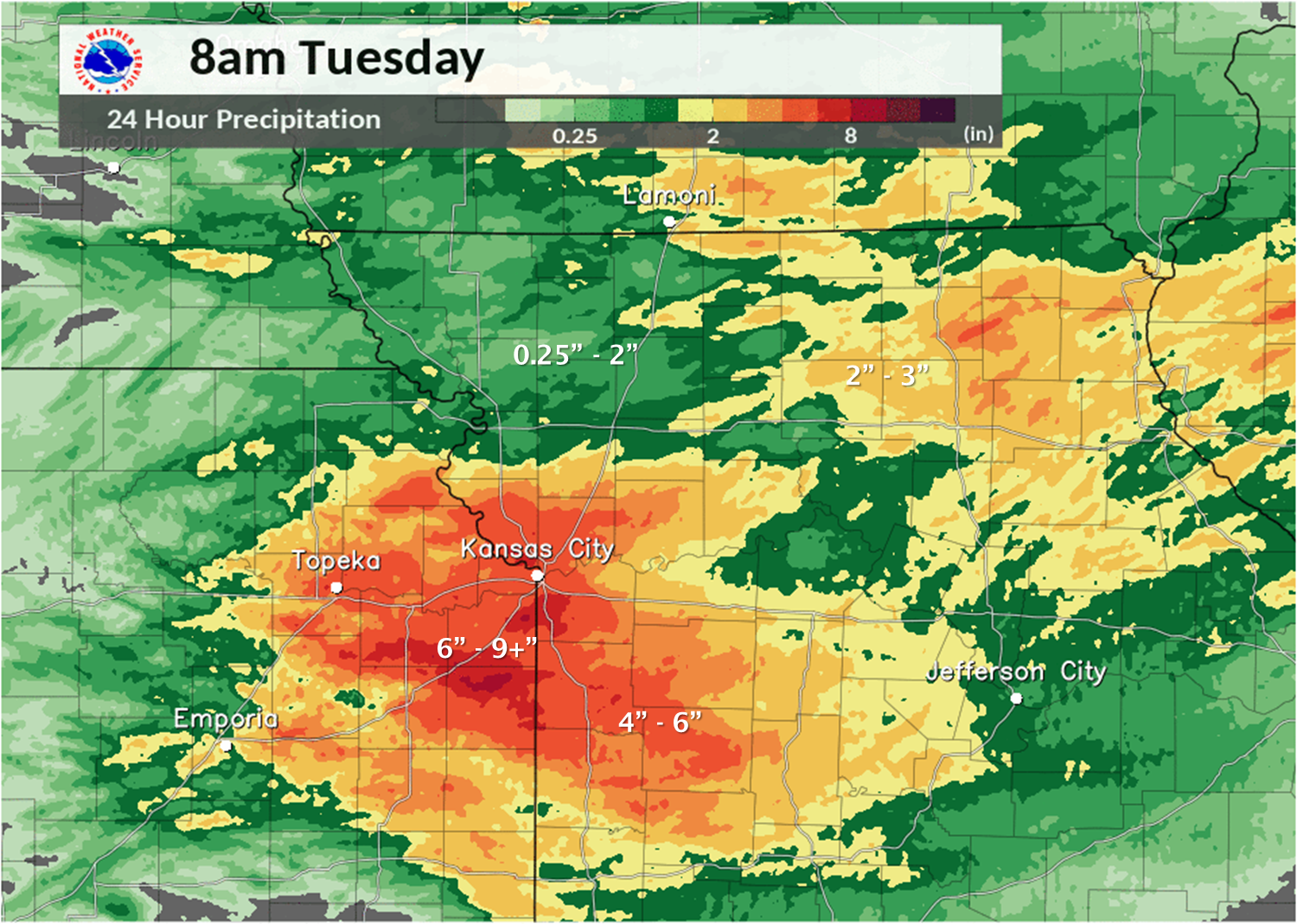 |
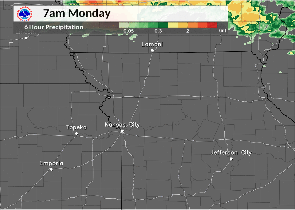
| Loop of 6-hour rainfall amounts as seen by radar (with inputs from gauges), hour-by-hour. Starting at 7am CDT Monday, August 21st, ending 12pm CDT Tuesday, August 22nd. | 24-hour radar (with inputs from gauges) rainfall amounts, ending 8am CDT Tuesday, August 22nd. |
 |
 |
 |
| 48-hour Rainfall Totals in the northern Kansas City metro area. Courtesy of StormWatch |
48-hour Rainfall Totals in the southern Kansas City metro area. Courtesy of StormWatch |
48-hour Rainfall Totals in Overland Park, KS. Courtesy of StormWatch |
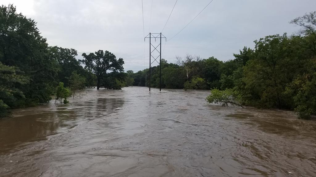
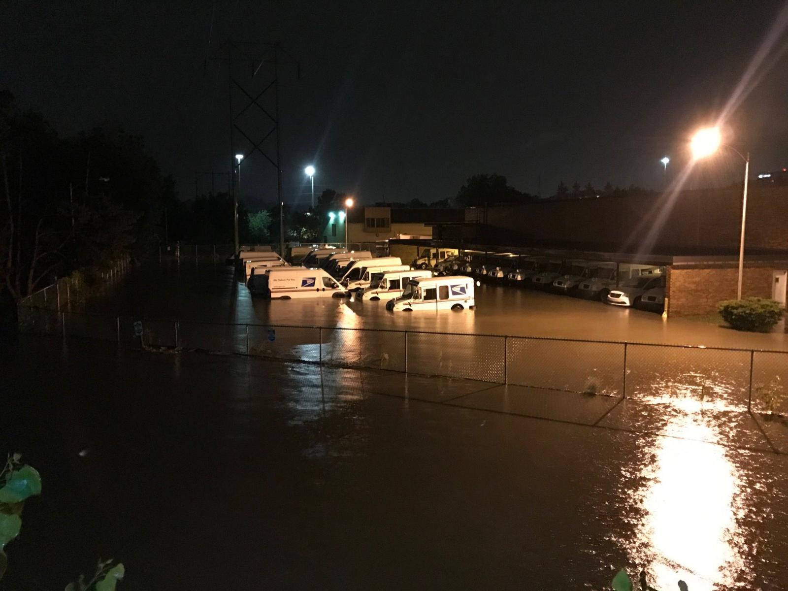
Photos & Video:
 |
 |
 |
 |
| Indian Creek Trail entrance at 99th Street Image: @dbarkwoof |
Postal center at Indian Creek Parkway Image: Johnson County Emergency Management |
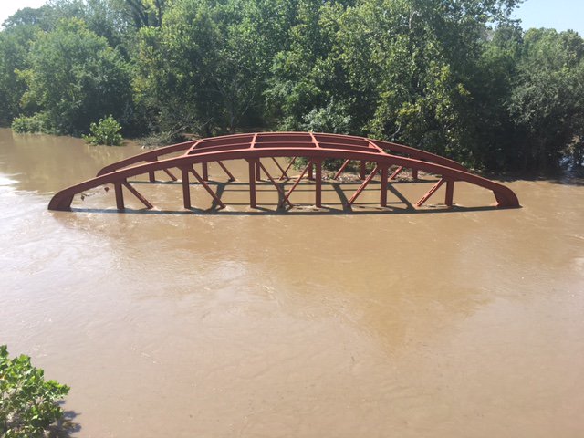
South KCMO Old Red Bridge over the Blue River Image: Tim Hansen |
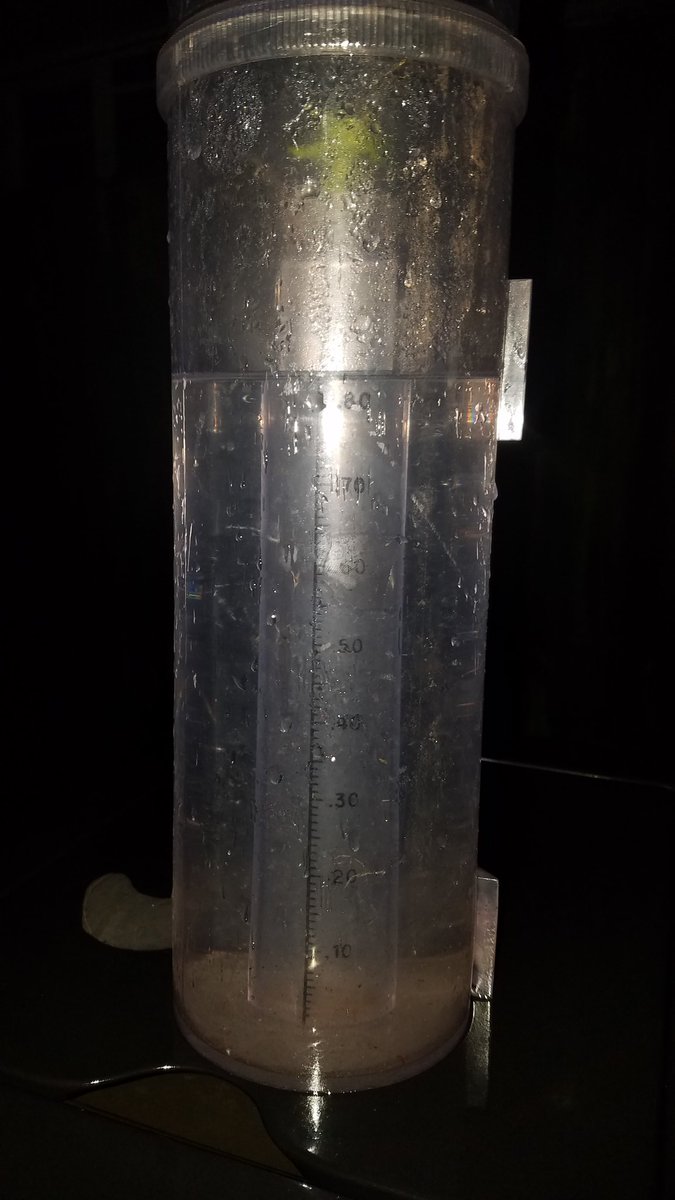
Some areas saw over 9 inches of rain on the night of August 21 into the morning of August 22. Image: Dan Hawblitzel |
Storm Reports
PRELIMINARY LOCAL STORM REPORT...SUMMARY
NATIONAL WEATHER SERVICE KANSAS CITY/PLEASANT HILL MO
112 PM CDT TUE AUG 22 2017

..TIME...   ...EVENT...      ...CITY LOCATION...     ...LAT.LON...
..DATE...   ....MAG....      ..COUNTY LOCATION..ST.. ...SOURCE....
            ..REMARKS..

0852 AM     FLASH FLOOD      3 E STANLEY             38.85N 94.61W
08/22/2017                   JOHNSON            KS   BROADCAST MEDIA

            FAMILY STRANDED ON ROOF AT 151ST ST AND
            KENNETH RD.

0802 AM     HEAVY RAIN       WEATHERBY LAKE          39.24N 94.69W
08/22/2017  M7.95 INCH       PLATTE             MO   NWS EMPLOYEE


0700 AM     FLASH FLOOD      1 WNW HOLDEN            38.72N 94.00W
08/22/2017                   JOHNSON            MO   NWS EMPLOYEE

            LOW WATER CROSSING OVER NUMEROUS ROADWAYS
            NEAR HOLDEN.

0551 AM     FLASH FLOOD      3 NW GRANDVIEW          38.93N 94.57W
08/22/2017                   JACKSON            MO   FIRE DEPT/RESCUE

            WATER RESCUE IN PROGRESS AT E RED BRIDGE RD
            AND BLUE RIVER RD.

0530 AM     HEAVY RAIN       1 S DE SOTO             38.97N 94.97W
08/22/2017  M9.30 INCH       JOHNSON            KS   TRAINED SPOTTER


0516 AM     FLASH FLOOD      4 S BELTON              38.75N 94.53W
08/22/2017                   CASS               MO   PUBLIC

            REPORT VIA TWITTER; BASEMENT FLOODED.

0504 AM     HEAVY RAIN       5 S KANSAS CITY         39.02N 94.59W
08/22/2017  M9.20 INCH       JACKSON            MO   NWS EMPLOYEE


0412 AM     FLASH FLOOD      2 NNE HILLSDALE         38.70N 94.84W
08/22/2017                   MIAMI              KS   EMERGENCY MNGR

            US 169 CLOSED SOUTH OF SPRING HILL DUE TO
            FLASH FLOODING.

0411 AM     FLASH FLOOD      3 ENE NEW LANCASTER     38.48N 94.69W
08/22/2017                   MIAMI              KS   EMERGENCY MNGR

            69 HIGHWAY AT 359TH STREET CLOSED DUE TO
            FLASH FLOODING.

0340 AM     FLASH FLOOD      7 S EDGERTON            38.67N 94.99W
08/22/2017                   MIAMI              KS   PUBLIC

            NUMEROUS ROAD CLOSURES IN NORTHERN MIAMI
            COUNTY. FLOOD WATERS APPROACHING A
            RESIDENCE.

0258 AM     FLASH FLOOD      3 WSW GRANDVIEW         38.88N 94.59W
08/22/2017                   JACKSON            MO   PUBLIC

            APARTMENT COMPLEX BEING EVACUATED ALONG
            HOLMES RD.

0249 AM     FLASH FLOOD      2 N RAYTOWN             39.03N 94.47W
08/22/2017                   JACKSON            MO   FIRE DEPT/RESCUE

            WATER RESCUE. WOMAN SWEPT INTO ROUND GROVE
            CREEK NEAR RAYTOWN ROAD.

0246 AM     FLASH FLOOD      5 NW GRANDVIEW          38.94N 94.60W
08/22/2017                   JACKSON            MO   EMERGENCY MNGR

            INDIAN CREEK RUSHING OVER THE WORNALL ROAD
            BRIDGE.

0237 AM     FLASH FLOOD      2 ESE BELTON            38.80N 94.50W
08/22/2017                   CASS               MO   LAW ENFORCEMENT

            NUMEROUS CLOSED ROADS ACROSS CASS COUNTY.

0235 AM     FLASH FLOOD      2 WSW RIVERSIDE         39.17N 94.64W
08/22/2017                   PLATTE             MO   EMERGENCY MNGR

            2 FEET OF WATER TRAPPED EMPLOYEES IN THEIR
            BUSINESSES IN THE HORIZONS INDUSTRIAL
            DISTRICT.

0205 AM     FLASH FLOOD      3 WSW RAYTOWN           38.99N 94.52W
08/22/2017                   JACKSON            MO   FIRE DEPT/RESCUE

            WATER RESCUE NEAR SWOPE PARK.

0146 AM     FLASH FLOOD      2 N BELTON              38.84N 94.53W
08/22/2017                   JACKSON            MO   FIRE DEPT/RESCUE

            WATER RESCUE.

0123 AM     FLASH FLOOD      HARRISONVILLE           38.65N 94.35W
08/22/2017                   CASS               MO   BROADCAST MEDIA

            SEVERAL STREETS UNDER 2-3 FEET OF WATER.
            CARS STRANDED.

0111 AM     FLASH FLOOD      2 E KANSAS CITY         39.10N 94.53W
08/22/2017                   JACKSON            MO   PUBLIC

            WATER RESCUE AT 12TH AND JACKSON.

1256 AM     FLASH FLOOD      2 ESE OLATHE            38.87N 94.78W
08/22/2017                   JOHNSON            KS   EMERGENCY MNGR

            SEVERAL FEET OF STANDING WATER ALONG CREEK
            AT 143RD AND LOCUST.

1240 AM     FLASH FLOOD      KANSAS CITY             39.10N 94.57W
08/22/2017                   JACKSON            MO   BROADCAST MEDIA

            RAMP FROM US 71 TO I-670 IS FLOODED. VEHICLE
            STRANDED.

1034 PM     FLASH FLOOD      1 SW KANSAS CITY        39.09N 94.59W
08/21/2017                   JACKSON            MO   PUBLIC

            2 TO 3 FEET OF WATER ON I-35 SOUTHBOUND NEAR
            DOWNTOWN.

1025 PM     FLASH FLOOD      1 NE LANSING            39.26N 94.88W
08/21/2017                   LEAVENWORTH        KS   EMERGENCY MNGR

            KS HWY 5 SHUT DOWN DUE TO WATER OVER ROAD AT
            SEVENMILE CREEK.

1023 PM     FLASH FLOOD      1 SE RIVERSIDE          39.17N 94.60W
08/21/2017                   PLATTE             MO   EMERGENCY MNGR

            WATER RESCUE ONGOING.

1018 PM     FLASH FLOOD      3 SSW KANSAS CITY       39.05N 94.59W
08/21/2017                   JACKSON            MO   EMERGENCY MNGR

            3 FEET OF WATER AT WESTPORT ROAD AND MILL
            ROAD.

1017 PM     FLASH FLOOD      2 SW KANSAS CITY        39.07N 94.61W
08/21/2017                   JACKSON            MO   EMERGENCY MNGR

            2 TO 3 FEET OF WATER AT 31ST AND SOUTHWEST
            BLVD.

1007 PM     FLASH FLOOD      SMITHVILLE              39.39N 94.59W
08/21/2017                   CLAY               MO   PUBLIC

            US 169 CLOSED DUE TO HIGH WATER.

1000 PM     TSTM WND GST     DE SOTO                 38.98N 94.97W
08/21/2017  M63 MPH          JOHNSON            KS   TRAINED SPOTTER


0800 PM     FLASH FLOOD      CUMMINGS                39.46N 95.24W
08/21/2017                   ATCHISON           KS   TRAINED SPOTTER

            WATER FLOWING OVER ROADWAYS.

0640 PM     TSTM WND GST     3 E PILOT GROVE         38.87N 92.85W
08/21/2017  E70 MPH          COOPER             MO   TRAINED SPOTTER


0615 PM     TSTM WND DMG     8 SW NELSON             38.90N 93.13W
08/21/2017                   PETTIS             MO   PUBLIC

            LARGE TREE DOWN, POWER LINES DOWN AND ROOF
            TORN OFF A BARN.

0530 PM     FLASH FLOOD      2 E LIBERTY             39.24N 94.39W
08/21/2017                   CLAY               MO   PUBLIC

            BRIDGE OVER RUSH CREEK CLOSED DUE TO HIGH
            WATER.

0510 PM     FLASH FLOOD      MOSBY                   39.31N 94.29W
08/21/2017                   CLAY               MO   FIRE DEPT/RESCUE

            SCHOOL BUS STRANDED DUE TO HIGH WATER.
            CHILDREN ON BOARD.

0423 PM     FLASH FLOOD      RIVERSIDE               39.18N 94.61W
08/21/2017                   PLATTE             MO   LAW ENFORCEMENT

            LINE CREEK OVER IT'S BANK AT HOMESTEAD ROAD
            AND HOMESTEAD TER.

0423 PM     FLASH FLOOD      RIVERSIDE               39.17N 94.61W
08/21/2017                   PLATTE             MO   LAW ENFORCEMENT

            W PLATTE ROAD CLOSING BOTH LANES.

0421 PM     HAIL             RIVERSIDE               39.18N 94.61W
08/21/2017  E1.00 INCH       PLATTE             MO   EMERGENCY MNGR


0410 PM     FLASH FLOOD      1 WNW PARKVILLE         39.20N 94.71W
08/21/2017                   PLATTE             MO   BROADCAST MEDIA

            NUMEROUS WATER RESCUES. RUSH CREEK IS
            FLOODING.

0353 PM     HEAVY RAIN       4 N OAKVIEW             39.27N 94.56W
08/21/2017  E3.15 INCH       CLAY               MO   NWS EMPLOYEE

            IN 1.5 HOURS.

0337 PM     FLASH FLOOD      2 N PLATTE WOODS        39.25N 94.65W
08/21/2017                   PLATTE             MO   EMERGENCY MNGR

            HWY 152 FLOODED NEAR GREEN HILLS DR.

0336 PM     HEAVY RAIN       2 NE LAKE WAUKOMIS      39.25N 94.62W
08/21/2017  E2.70 INCH       PLATTE             MO   PUBLIC

            TOTAL SO FAR TODAY.

0335 PM     TSTM WND DMG     3 NE LAKE WAUKOMIS      39.26N 94.60W
08/21/2017                   CLAY               MO   PUBLIC

            DOWNED TREE LIMBS LESS THAN 2 INCHES IN
            DIAMETER.

0328 PM     HAIL             1 SE OAKS               39.19N 94.55W
08/21/2017  E0.25 INCH       CLAY               MO   EMERGENCY MNGR


0326 PM     HEAVY RAIN       4 N OAKVIEW             39.26N 94.58W
08/21/2017  E3.50 INCH       CLAY               MO   PUBLIC

            TOTAL SO FAR TODAY.

0325 PM     FLOOD            PLEASANT VALLEY         39.22N 94.48W
08/21/2017                   CLAY               MO   LAW ENFORCEMENT

            WATER OVER ROADWAY.

0321 PM     FLOOD            6 E FERRELVIEW          39.30N 94.56W
08/21/2017                   CLAY               MO   AMATEUR RADIO

            SMALL CREEKS OUT OF BANKS; NO DANGER TO
            RESIDENTS SO FAR.

0312 PM     FLOOD            KEARNEY                 39.37N 94.37W
08/21/2017                   CLAY               MO   EMERGENCY MNGR

            WATER OVER ROADWAY IN SEVERAL LOCATIONS IN
            KEARNEY AREA AND ALONG 92 HWY. CURRENTLY
            PASSABLE.

0243 PM     FLOOD            5 ESE FERRELVIEW        39.29N 94.58W
08/21/2017                   CLAY               MO   AMATEUR RADIO

            SHOAL CREEK PARKWAY AND N OAK INTERSECTION
            UNDERWATER. CULVERTS CAN'T HANDLE. 1.4
            INCHES OF RAIN SO FAR.
 |
Media use of NWS Web News Stories is encouraged! Please acknowledge the NWS as the source of any news information accessed from this site. |
|


 Weather Story
 Weather Map
 Local Radar