
Tropical system in the Gulf expected to gradually strengthen the next couple of days off the Florida Panhandle and Alabama coasts. Instances of flash flooding will be possible through Thursday along the eastern and central Gulf Coast. Severe thunderstorms will develop and move along a cold front crossing the Upper Midwest, and through the Ohio Valley/Mid-Atlantic on Tuesday. Read More >
|
During the afternoon and evening of Sunday, October 4th, 1998, two separate rounds of thunderstorms produced unusually high rainfall rates in the Kansas City metropolitan area. The intense rainfall, on top of already saturated soils and in a largely urban environment, quickly resulted in excessive runoff and flash flooding. Flash flooding along Brush Creek, Turkey Creek and Indian Creek resulted in eleven people losing their lives - eight lives alone were claimed as Brush Creek inundated the Prospect Road bridge. Ten of the eleven deaths occurred after sunset and in automobiles, traditionally high risk factors associated with flash floods. In addition to the fatalities in Kansas City, another death attributed to flash flooding was reported in St. Joseph, Missouri. The flash flood received national attention, as millions watched as the deluge swamped a nationally televised football game between the Kansas City Chiefs and Seattle Seahawks. In addition to the flash flooding in Kansas City, reports of hail up to quarter-sized, wind gusts up to 70 miles per hour and high impact river flooding was reported. All toll, damages were estimated at over $50 million. At the time the flash flood of October 4th, 1998, was the second deadliest flash flood in Kansas City's history, eclipsed only by the September 11-12, 1977 flash flood that killed 29 people and resulted in over $100 million in property damages that affected the Country Club Plaza. |
 |
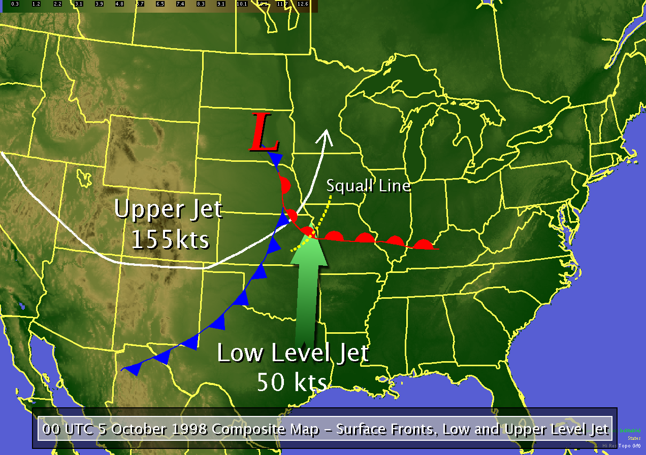 |
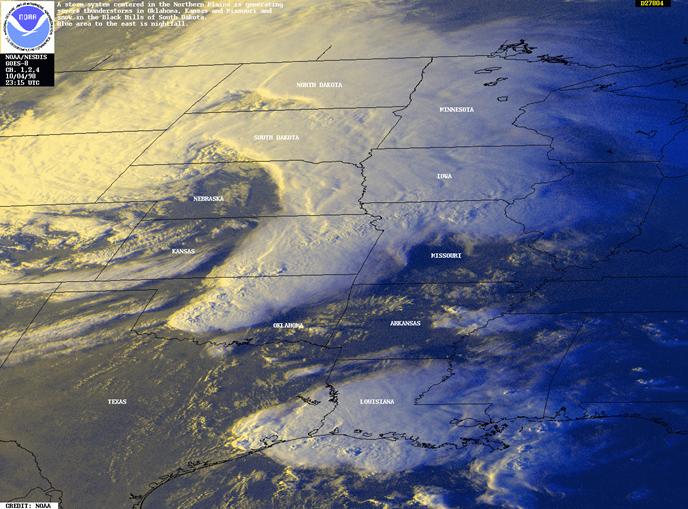
| Visible satellite image of thunderstorms erupting over the central plains at 3 pm CDT on October 4, 1998 | Composite of upper level storm and surface front interaction on October 4, 1998 - An upper level storm system moving from the western United States activated thunderstorms along both the cold front and warm front located across central and eastern Kansas during the afternoon hours of October 4, 1998. |
 |
 |
|
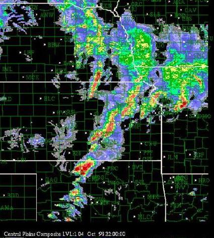
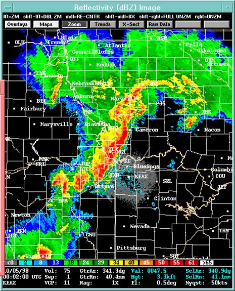
| Regional radar from 3 pm CDT depicting multiple clusters and lines of severe, heavy rain-bearing thunderstorms impacting eastern Kansas and western Missouri. |
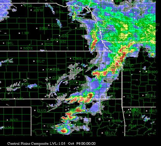
Regional radar from 7 pm CDT depicting a well developed line of severe, heavy rain-bearing thunderstorms stretching from north central Missouri across the Kansas City area into central Oklahoma. |
 |
 |
 |
||
|
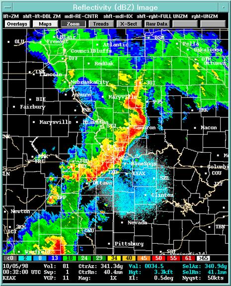
Radar image from the National Weather Service in Pleasant Hill, Missouri around 6 pm CDT on October 4, 1998.
|
Radar image from the National Weather Service in Pleasant Hill, Missouri around 6:30 pm CDT on October 4, 1998.
|
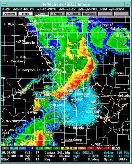
Radar image from the National Weather Service in Pleasant Hill, Missouri around 7 pm CDT on October 4, 1998.
|
 |
 |
|
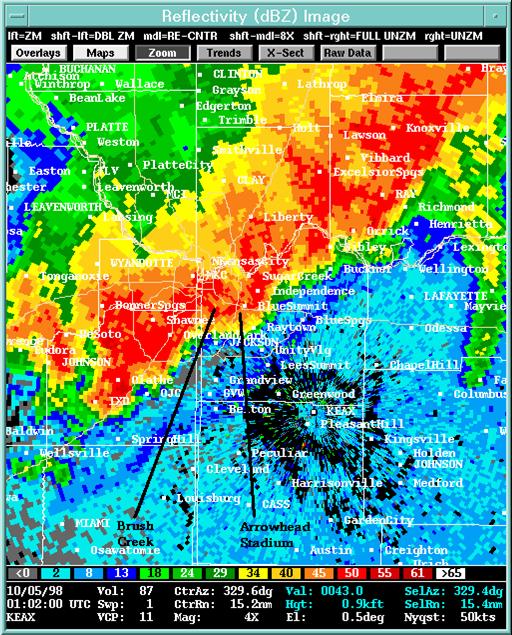
| Radar image from the National Weather Service in Pleasant Hill, Missouri around 7 pm CDT denoting the location of the Brush Creek Basin and Arrowhead Stadium. | Hourly rainfall estimate from the National Weather Service WSR-88D radar located in Pleasant Hill, Missouri. In the period between approximately 6 pm CDT and 7 pm CDT, between 3 and 4 inches of rain fell over the Indian Creek and Turkey Creek basins. |
 |
 |
|
|
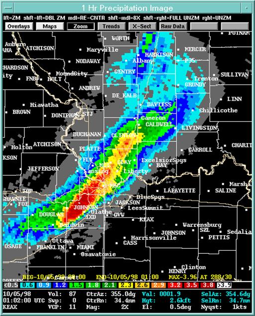
Hourly rainfall estimate from the National Weather Service WSR-88D radar located in Pleasant Hill, Missouri. In the period between approximately 7 pm CDT and 8pm CDT, between 4 and 5 inches of rain fell over the Brush Creek basin. |
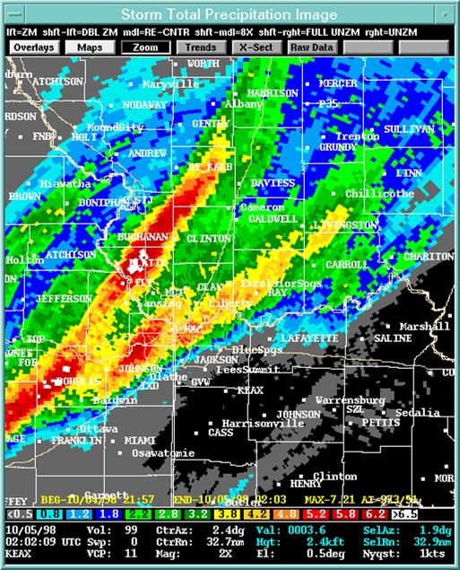
Analysis of rainfall that fell across eastern Kansas and western Missouri during the evening of October 4, 1998. Rainfall in excess of 5 inches was common from Overland Park, Kansas area to the Plaza, Waldo and Brookside areas of Kansas City, Missouri. Further east, a broad swath of rainfall in excess of 7 inches from the Richmond to Carrollton areas. |
 |
 |
|
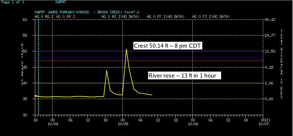
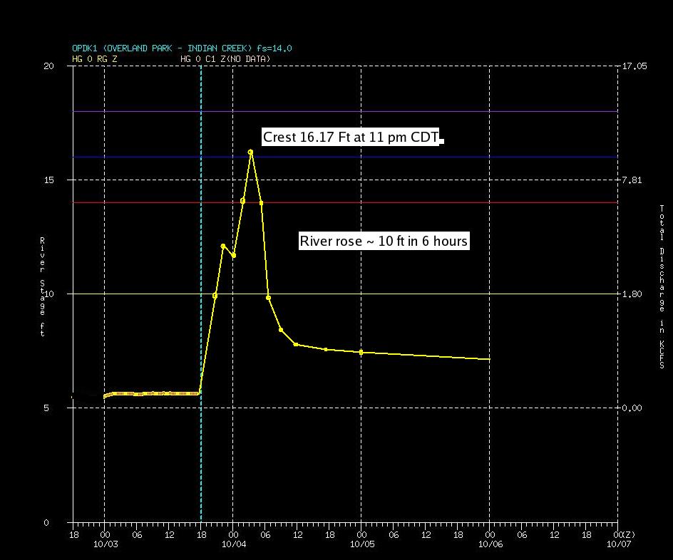
| Graph depicting the response of Brush Creek near Ward Parkway to rainfall on October 4, 1998. The river crested at 50.14 feet, rising nearly 13 feet in one hour. | Graph depicting the response of Indian Creek near Overland Park to rainfall on October 4, 1998. The river crested at 16.17 feet, rising nearly 10 feet in six hours. |


 Weather Story
 Weather Map
 Local Radar