
A Nor'easter well off the East Coast will slowly track north this week and may gain some subtropical characteristics. Strong onshore winds will bring flooding, dangerous marine conditions, and beach erosion along the Mid-Atlantic coast. A Pacific storm will bring gusty winds, showers and thunderstorms, and mountain snow to portions of California and the Southwest U.S. Wednesday and Thursday. Read More >
Kansas City/Pleasant Hill, MO
Weather Forecast Office
|
Heavy Rain and Flooding Affect Eastern Kansas Through Central Missouri
|
||||
|
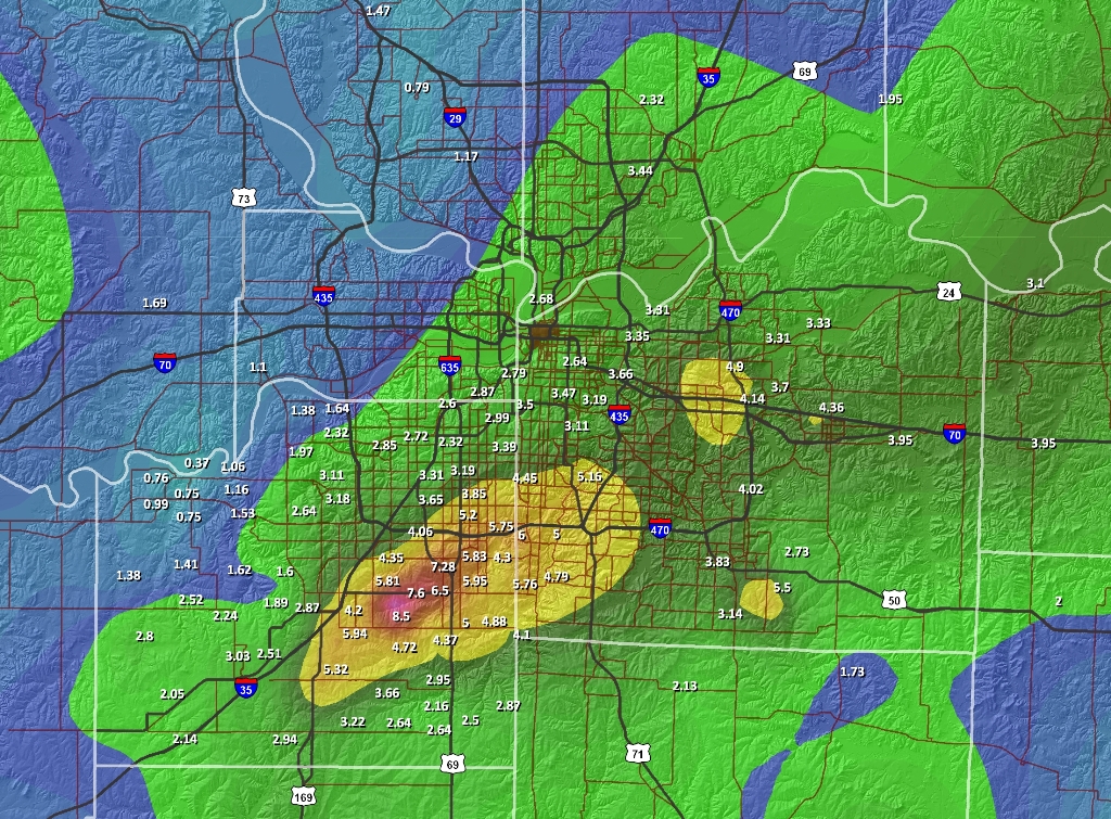
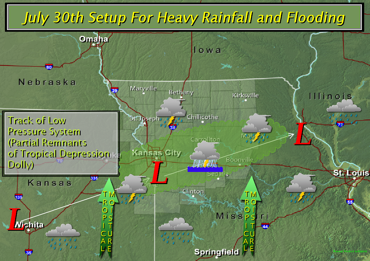
The partial remnants of Tropical Depression Dolly, which impacted the lower Texas Gulf Coast nearly a week ago, ushered copious amount of deep tropical moisture into the central plains and Midwest overnight. As an upper level system from the central Rockies interacted with Dolly's remnants, numerous showers and thunderstorms developed across eastern Kansas through central Missouri. The slow movement of the storm system coupled with the training and back building individual cells set the stage for very heavy rainfall and flooding. Widespread amounts of 2 to 4 inches were noted from extreme eastern Kansas through central Missouri. Along the Interstate 70 was particularly hard hit with upwards of 5 to 8.5 inches of rain being recorded overnight. Several flash flood warnings were issued overnight with numerous reports of flash flooding received. In addition, several rivers responded to the rainfall prompting several river flood warnings to be issued. |
||||
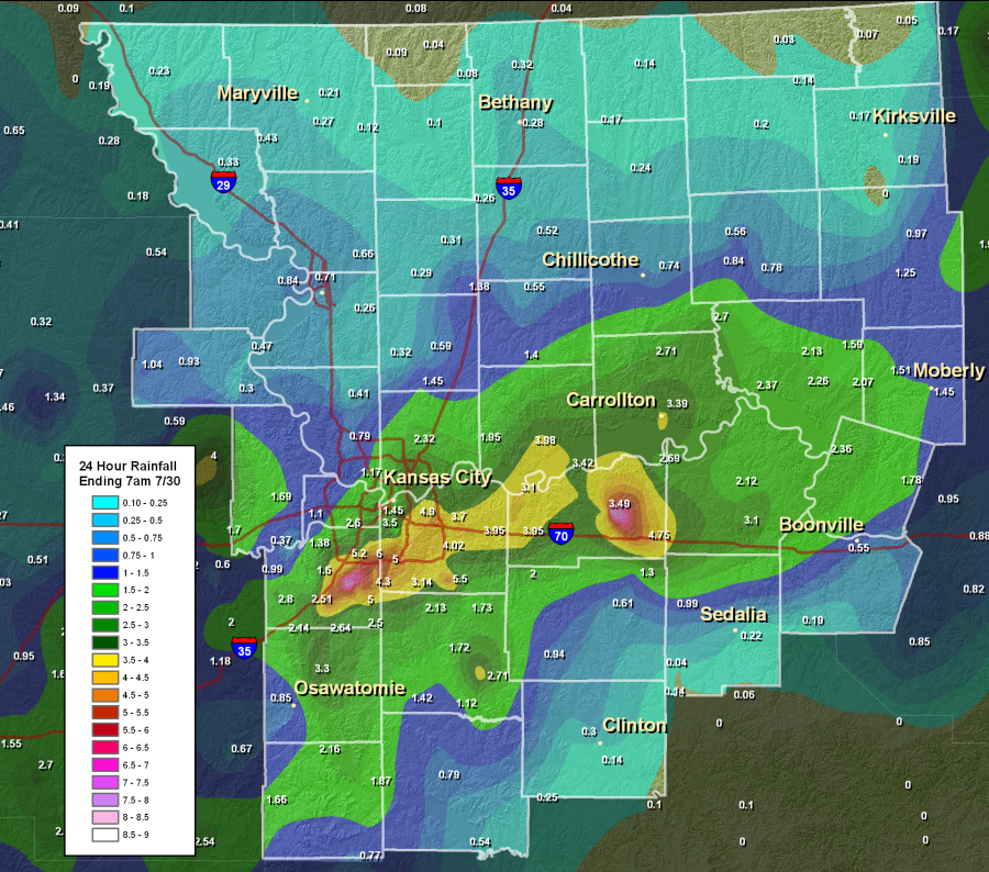 |
The image on the left shows the 24 hour storm total precipitation ending at 7AM on July 30th. The image on the right shows the 24 hour storm total precipitation ending at 7AM on July 30th for the Kansas City Metro. (Click on images to enlarge) |
 |
||
| The image below depicts the atmospheric setup which resulted in heavy rainfall and flooding across the NWS Kansas City/Pleasant Hill forecast area. (click to enlarge) | ||||
 |
||||
Hazards
Decision Support
Situation Report
Local Weather Story
Submit Report
Storm Prediction Center
Weather Prediction Center
National Hurricane Center
Active Alerts
National Radar
Current Weather
Local Radar
Local Precipitation/Temperature
National Radar
Satellite
Observations
Observed Precipitation
Water and Air
National Rivers
Local Rivers
Air Quality
Missouri Basin RFC
Forecasts
Decision Support
Weather Story
Forecast Discussion
Local Fire Weather
National Fire Weather
Aviation Weather
FAA Center Weather
Graphical Forecasts
Weather Prediction Center
Space Weather Center
Climate
Climate Prediction Center
KC Records and Normals
KC Holiday Climate
KC Seasonal Rankings
National Climate Services
Climate Data Center
Drought
Local Storm Reports

US Dept of Commerce
National Oceanic and Atmospheric Administration
National Weather Service
Kansas City/Pleasant Hill, MO
1803 North 7 Highway
Pleasant Hill, MO 64080-9421
816-540-6132 (6021 automated weather)
Comments? Questions? Please Contact Us.


 Weather Story
 Weather Map
 Local Radar
 Follow us on X
 Follow us on Facebook
 Follow us on YouTube
 EAX RSS Feed