
A slow moving front will bring rounds of strong to severe thunderstorms and heavy rainfall to the central Plains eastward to the east-central U.S.. The first widespread significant heat wave of summer for the Intermountain West and Plains is expected to develop today and expand through next week. Dangerous heat will continue to impact portions of the Southwest and Southeast. Read More >
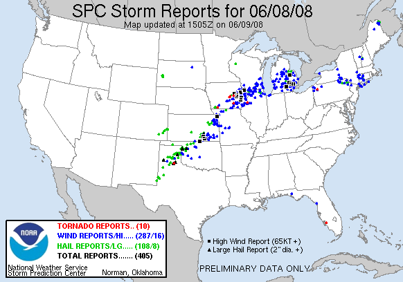
...Severe Weather Pummels the Region on June 8-9, 2008...
On the afternoon of June 9th, an advancing cold front ignited a warm and very moist airmass in place across much of the central and southern Plains. A squall line of thunderstorms erupted from southwest Iowa all the way back to the Texas panhandle, producing widespread severe weather and flooding along its path.
Severe weather across the local region was confined primarily along the Interstate 35 corridor, with mainly 60-70 mph wind reports and isolated hail. As the squall line evolved during the early evening hours, a gust front pushed some 10-15 miles out ahead of the line. Strong wind gusts of 40 to 60 mph and threatening skies were observed with this feature over many areas, with frequent reports of rotations and other funnel-like features observed along the menacing shelf cloud feature. Funnel clouds and tornadoes are not typically observed along an orphaned gust front, and no touchdowns were observed, nor were any tornado warnings issued by the National Weather Service.
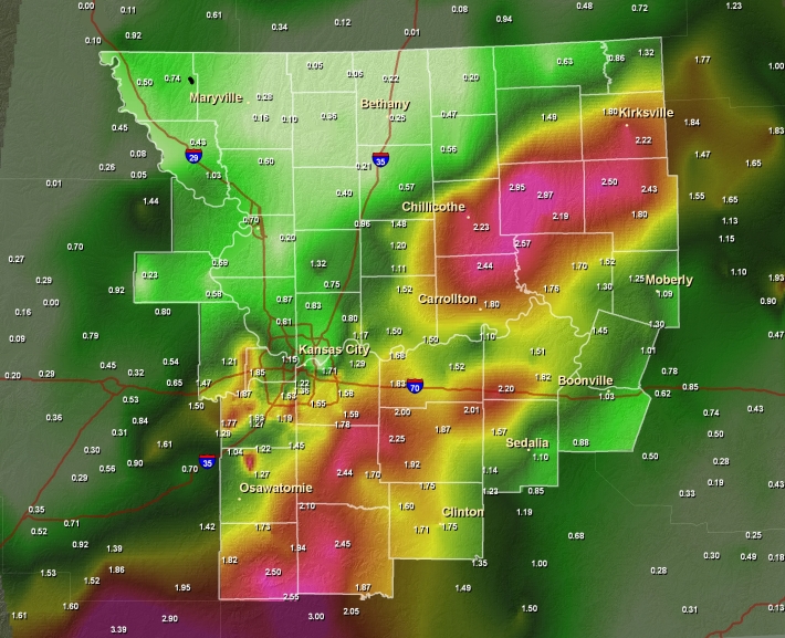
With the gust front removed from the line of thunderstorms, the forward speed slowed down, allowing torrential rainfall to fall across many areas overnight. Precipitation amounts of two to two-and-a-half inches were commonly observed from Prescott Kansas to Harrisonville to near Marshall, with another swath of equal heavy rain observed Chillicothe and Carrollton northeast toward Kirksville.
The graphics below depict observed precipitation across the area as accumulated from hundreds of automated gauge sites and cooperative weather observers. The second graph depicts reports of severe weather across the region last night.
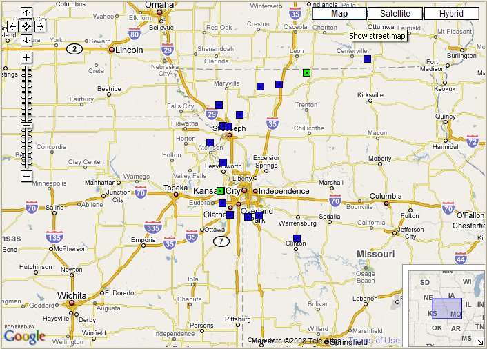
Hail Reports
| Time (UTC) | Size (inches) | Location | County | State | Lat | Lon | Comments |
| 2315 | 1.00 | 1 N PRINCETON | MERCER | MO | 40.41 | -93.59 | (EAX) |
| 0018 | 1.00 | 1 W DE SOTO | JOHNSON | KS | 38.97 | -94.97 | 60 MPH WINDS WAS ALSO REPORTED. (EAX) |
Wind Reports
| Time (UTC) | Speed (mph) | Location | County | State | Lat | Lon | Comments |
| 2125 | UNK | 1 SW FILLMORE | ANDREW | MO | 40.02 | -94.99 | ESTIMATED 55 TO 65 MPH WINDS. DESTROYED BARN AND SHED. (EAX) |
| 2153 | 76 | ST JOSEPH ARPT | BUCHANAN | MO | 39.77 | -94.92 | (EAX) |
| 2200 | UNK | ST JOSEPH | BUCHANAN | MO | 39.76 | -94.85 | NUMEROUS REPORTS OF TREE DAMAGE. 209N 2ND ST...27TH AND PENN...5TH AVE...800 BLOCK MAIN ST TREE ON HOUSE...WOODBINE AND COUNTY LINE RD TREE HIT TRUCK. TIME ESTIMATED. (EAX) |
| 2206 | UNK | ATCHISON | ATCHISON | KS | 39.56 | -95.13 | SHERIFF OFFICE RELAYED REPORT OF A COUPLE TREES BLOWN OVER IN THE CITY OF ATCHISON. ONE OF THE TREES WAS THREE FEET IN DIAMETER. TIME ESTIMATED. (EAX) |
| 2212 | 60 | 3 NNE COSBY | ANDREW | MO | 39.9 | -94.66 | (EAX) |
| 2245 | UNK | ALBANY | GENTRY | MO | 40.25 | -94.33 | COUNTY SHERIFF OFFICE REPORTS A FEW POWER LINES DOWN IN THE CITY OF ALBANY. TIME ESTIMATED. (EAX) |
| 2256 | UNK | BETHANY | HARRISON | MO | 40.27 | -94.03 | COUNTY SHERIFF OFFICE REPORTS TREE LIMBS DOWN IN CITY OF BETHANY. (EAX) |
| 2305 | 60 | LEAVENWORTH | LEAVENWORTH | KS | 39.32 | -94.92 | A FEW SMALL BRANCHES DOWN AS WELL. (EAX) |
| 0010 | UNK | COATSVILLE | SCHUYLER | MO | 40.58 | -92.63 | TREE BLOWN DOWN. (EAX) |
| 0022 | 70 | DE SOTO | JOHNSON | KS | 38.97 | -94.95 | AT INTERSECTION OF K-10 HIGHWAY AND KILL CREEK RD. (EAX) |
| 0039 | 60 | GARDNER | JOHNSON | KS | 38.81 | -94.93 | (EAX) |
| 0059 | 60 | 2 E HILLSDALE | MIAMI | KS | 38.67 | -94.81 | (EAX) |
| 0115 | 60 | 2 NW FREEMAN | CASS | MO | 38.64 | -94.53 | (EAX) |
| 0130 | 60 | HARRISONVILLE | CASS | MO | 38.66 | -94.35 | ESTIMATED 60 MPH WINDS AT MECHANICS STEET AND MAIN STREET. (EAX) |
| 0245 | UNK | 1 NE CLINTON | HENRY | MO | 38.38 | -93.75 | SIDE OF A BARN MISSING AND TOPS OF TREES BROKEN OFF. TIME ESTIMATED. (EAX) |


 Weather Story
 Weather Map
 Local Radar