
Widespread life-threatening flash and urban flooding will continue to pose a significant threat to life and property in south-central Texas. Catastrophic fiver flooding, with rapid rises on small streams, arroyos, and typically dry washes, is expected. Monsoonal showers persist across the Great Basin and Southwest with greatest flash flooding in southern Arizona. Read More >
...Thunderstorms Roll Across the Area Early on the 9th...
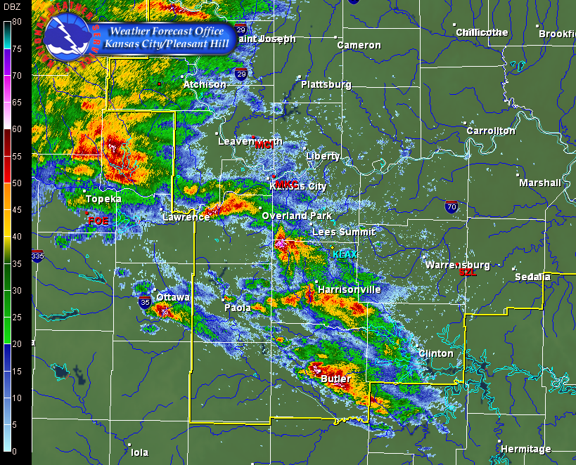
An early morning complex of thunderstorms rolled across portions of eastern Kansas and central Missouri during the morning hours of June 9th. These thunderstorms developed quickly by mid-morning lifting northeastward while producing large hail in locations from Belton to Butler and Clinton. A radar image below depicts this first round of thunderstorms which produced large hail. An additional area of thunderstorms developed over central Kansas and began to surge southeast towards the Kansas City metropolitan areas by early afternoon. As shown in the second radar image, several of these storms took on a "bowing" shape, often an indication of strong to even severe outflow winds. These thunderstorms raced over the same areas as were hit in the morning, producing tree damage with estimated winds at 60 mph.
 |
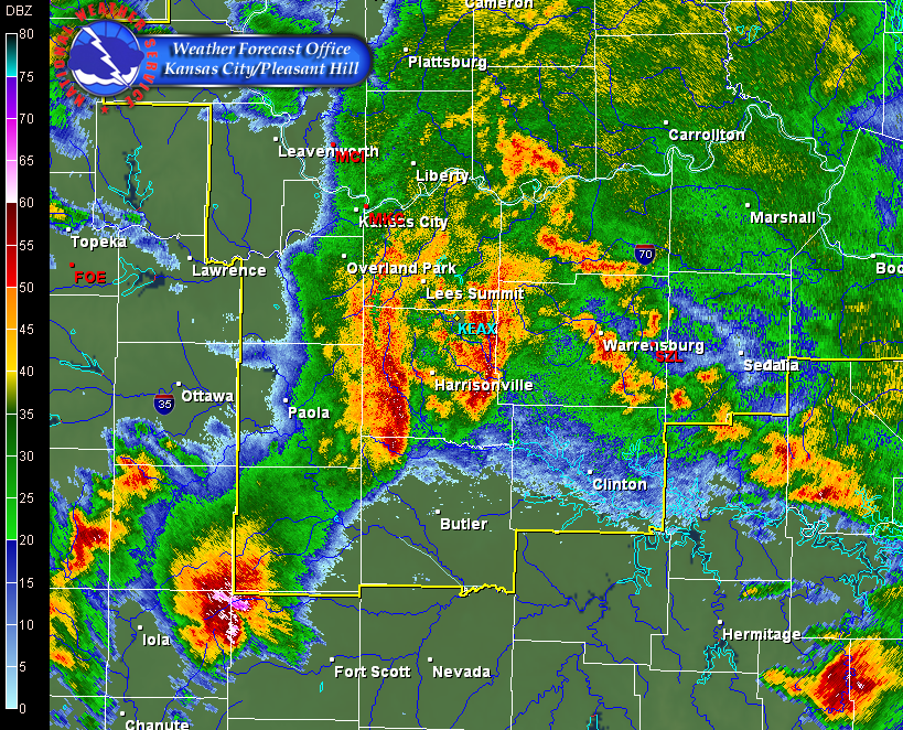 |
| Radar Image At 10 AM CDT | Radar Image at 130 PM CDT |
Storm Reports:
After this thunderstorm complex moved southeast and out of the area early in the afternoon, a remnant outflow (or temperature boundary) remained stationary across areas from Lees Summit southward to Clinton. Late in the afternoon and into the early evening hours, additional thunderstorms developed along this boundary, producing isolated reported of large hail. The image below depicts all of the storm reports received during the daytime and evening hours of the 9th.
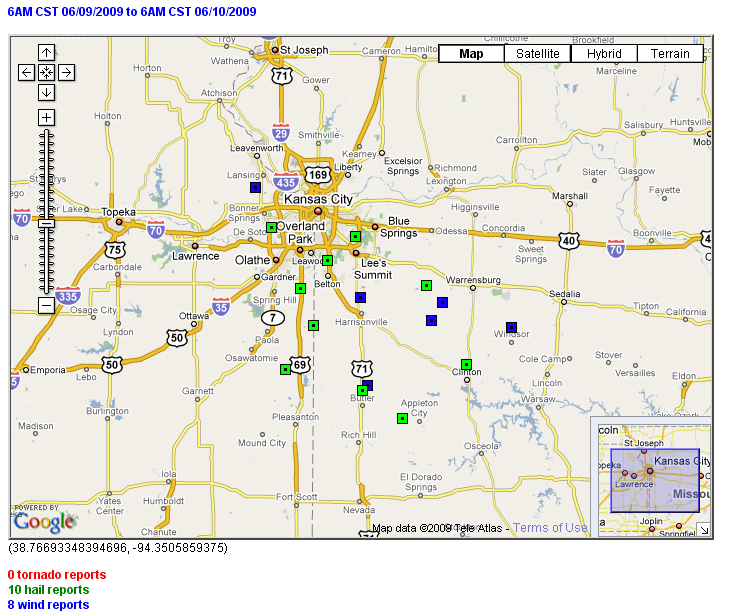 |
| Storm Reports Valid on June 9th |
Tornado Reports
| Time (UTC) | Location | County | State | Lat | Lon | Comments |
| No Reports | ||||||
Hail Reports
| Time (UTC) | Size (inches) | Location | County | State | Lat | Lon | Comments |
| 1505 | 1.50 | 5 N LOUISBURG | MIAMI | KS | 38.7 | -94.68 | (EAX) |
| 1530 | 0.88 | BUTLER | BATES | MO | 38.26 | -94.34 | (EAX) |
| 1530 | 2.50 | BELTON | CASS | MO | 38.82 | -94.53 | (EAX) |
| 1535 | 0.88 | 5 NNW ROCKVILLE | BATES | MO | 38.14 | -94.12 | (EAX) |
| 1655 | 1.25 | CLINTON | HENRY | MO | 38.37 | -93.77 | QUARTER TO HALF DOLLAR SIZED HAIL REPORTED IN CLINTON. (EAX) |
| 1720 | 1.75 | 3 W LENEXA | JOHNSON | KS | 38.96 | -94.84 | (EAX) |
| 1850 | 1.00 | HOLDEN | JOHNSON | MO | 38.71 | -93.99 | (EAX) |
| 0029 | 0.88 | 4 N DREXEL | CASS | MO | 38.54 | -94.61 | (EAX) |
| 0115 | 1.75 | LA CYGNE | LINN | KS | 38.35 | -94.76 | GOLFBALL SIZE HAIL (EAX) |
| 0125 | 0.75 | LEES SUMMIT | JACKSON | MO | 38.92 | -94.38 | PENNY SIZE HAIL (EAX) |
Wind Reports
| Time (UTC) | Speed (mph) | Location | County | State | Lat | Lon | Comments |
| 1425 | UNK | BLAIRSTOWN | HENRY | MO | 38.56 | -93.96 | 8 INCH LIMBS AND SMALL TREES KNOCKED DOWN. (EAX) |
| 1741 | 60 | BASEHOR | LEAVENWORTH | KS | 39.13 | -94.93 | (EAX) |
| 1845 | 64 | HARRISONVILLE | CASS | MO | 38.66 | -94.35 | (EAX) |
| 1848 | UNK | BLAIRSTOWN | HENRY | MO | 38.56 | -93.96 | DELAYED REPORT OF 8 INCH LIMBS AND SMALL TREES KNOCKED DOWN. CORRECTED FOR ESTIMATED TIME. (EAX) |
| 1857 | 60 | 7 SE HOLDEN | JOHNSON | MO | 38.64 | -93.9 | (EAX) |
| 1933 | UNK | WINDSOR | HENRY | MO | 38.53 | -93.52 | REPORT OF TREE BRANCHES DOWN...UP TO 2 INCHES IN DIAMETER. (EAX) |
| 1935 | UNK | CLINTON | HENRY | MO | 38.37 | -93.77 | 5 INCH DIAMETER TREE LIMB BLOWN DOWN. TIME IS ESTIMATED. (EAX) |
| 0150 | 60 | 2 NE BUTLER | BATES | MO | 38.28 | -94.31 | DELAYED REPORT. SPOTTER ALSO REPORTED DIME-SIZED HAIL. TIME ESTIMATED. (EAX) |


 Weather Story
 Weather Map
 Local Radar