
Widespread life-threatening flash and urban flooding will continue to pose a significant threat to life and property in south-central Texas. Catastrophic fiver flooding, with rapid rises on small streams, arroyos, and typically dry washes, is expected. Monsoonal showers persist across the Great Basin and Southwest with greatest flash flooding in southern Arizona. Read More >
El Paso, TX
Weather Forecast Office
Temperature and Precipitation Plot for El Paso, Texas for 2025
Temperature and Precipitation Plot for El Paso, Texas for 2024
Temperature and Precipitation Plot for El Paso, Texas for 2023
Temperature and Precipitation Plot for El Paso, Texas for 2022
Temperature and Precipitation Plot for El Paso, Texas for 2021
Temperature and Precipitation Plot for El Paso, Texas for 2020
Temperature and Precipitation Plot for El Paso, Texas for 2019
Temperature and Precipitation Plot for El Paso, Texas for 2018
Temperature and Precipitation Plot for El Paso, Texas for 2017
Temperature and Precipitation Plot for El Paso, Texas for 2016
Temperature and Precipitation Plot for El Paso, Texas for 2015
Temperature and Precipitation Plot for El Paso, Texas for 2014
Temperature and Precipitation Plot for El Paso, Texas for 2013
Temperature and Precipitation Plot for El Paso, Texas for 2012
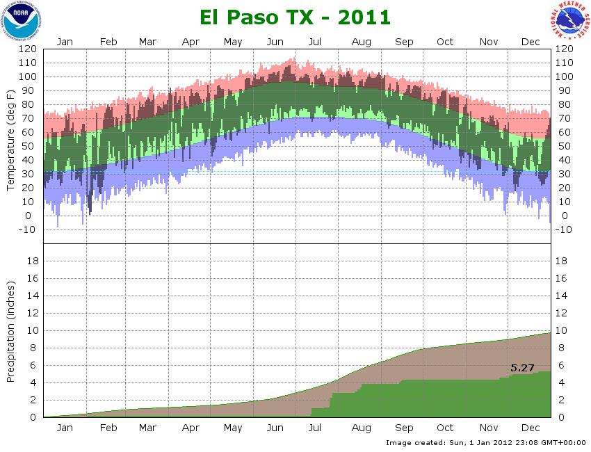
Temperature and Precipitation Plot for El Paso, Texas for 2011
Current Hazards
Outlooks
Hazardous Weather Outlook
Local Storm Reports
Public Information Statement
National
Heat Risk
Current Conditions
Local Observations
Satellite
Drought Monitor
Holloman AFB Radar
Regional highs/lows/precip
El Paso Radar
Rivers and Lakes
Forecasts
Forecast Discussion
Graphical Forecast
Hourly Forecast
Activity Planner
Fire Weather
Aviation Weather
Climate
El Paso Climate Data
Monthly Weather Digest
Climate Graphs
Monthly Climate Data
Climate Prediction
Storm Events Database
Santa Teresa Climate Data
US Dept of Commerce
National Oceanic and Atmospheric Administration
National Weather Service
El Paso, TX
7955 Airport Rd
Santa Teresa, NM 88008
(575) 589-4088
Comments? Questions? Please Contact Us.

