
Numerous severe thunderstorms are expected across a broad region from the Ohio Valley to the Mid-Atlantic and Northeast States today into tonight. Swaths of damaging wind gusts are expected and some tornadoes are possible. Bertha is expected to bring tropical storm conditions to portions of the Gulf Coast from the Florida Panhandle westward to southeastern Louisiana later today and Wednesday. Read More >
El Paso, TX
Weather Forecast Office
Temperature and Precipitation Plot for El Paso, Texas for 2025
Temperature and Precipitation Plot for El Paso, Texas for 2024
Temperature and Precipitation Plot for El Paso, Texas for 2023
Temperature and Precipitation Plot for El Paso, Texas for 2022
Temperature and Precipitation Plot for El Paso, Texas for 2021
Temperature and Precipitation Plot for El Paso, Texas for 2020
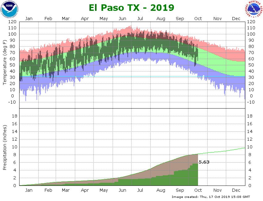
Temperature and Precipitation Plot for El Paso, Texas for 2019
Temperature and Precipitation Plot for El Paso, Texas for 2018
Temperature and Precipitation Plot for El Paso, Texas for 2017
Temperature and Precipitation Plot for El Paso, Texas for 2016
Temperature and Precipitation Plot for El Paso, Texas for 2015
Temperature and Precipitation Plot for El Paso, Texas for 2014
Temperature and Precipitation Plot for El Paso, Texas for 2013
Temperature and Precipitation Plot for El Paso, Texas for 2012
Temperature and Precipitation Plot for El Paso, Texas for 2011
Current Hazards
Outlooks
Hazardous Weather Outlook
Local Storm Reports
Public Information Statement
National
Heat Risk
Current Conditions
Regional highs/lows/precip
El Paso Radar
Rivers and Lakes
Local Observations
Satellite
Drought Monitor
Holloman AFB Radar
Forecasts
Forecast Discussion
Graphical Forecast
Hourly Forecast
Activity Planner
Fire Weather
Aviation Weather
Climate
El Paso Climate Data
Monthly Weather Digest
Climate Graphs
Monthly Climate Data
Climate Prediction
Storm Events Database
Santa Teresa Climate Data
US Dept of Commerce
National Oceanic and Atmospheric Administration
National Weather Service
El Paso, TX
7955 Airport Rd
Santa Teresa, NM 88008
(575) 589-4088
Comments? Questions? Please Contact Us.

