Irma Causes Widespread Damage in Georgia:
September 11, 2017
[Overview]
Overview:
Major Hurricane Irma made landfall in southwest Florida on September 10, 2017. Irma moved northward through the day on September 10th, gradually losing intensity but continuing to bring widespread wind damage and heavy rainfall along its track. By the morning of Monday, September 11th, then-Tropical Storm Irma moved into Georgia with a very large wind field containing at least tropical storm force wind gusts (39+mph). These high winds lasted several hours across most of the state, which resulted in many thousands of downed trees and caused 1.5 million customers in Georgia to lose power. Given the extensive damage, power was not restored to many areas for several days. With generally dry conditions prior to Irma's arrival, flooding issues in this area were relatively minor, though portions of southern and coastal Georgia outside of the NWS Atlanta/Peachtree City forecast area experienced more significant flooding as well as coastal storm surge.
Damaging Winds:
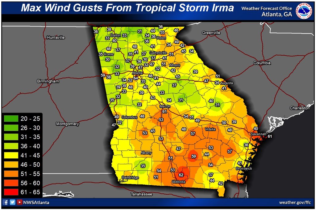
Widespread sustained winds of 30-45 mph with gusts in the 50-65 mph range downed numerous trees and power lines across the area. Many trees fell onto homes and businesses, causing additional damage. Unfortunately, at least two people were killed in the north Georgia due to falling trees with several others sustaining injuries. Below are some of the notable wind reports across the area during Tropical Storm Irma.
 |
|
This map displays peak recorded wind gusts across Georgia during Irma. (Click the map to enlarge it.) |
 |
|
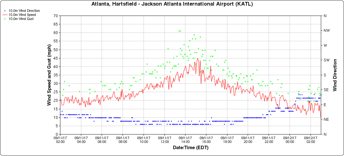
This graph shows wind direction and wind speed/gusts in miles per hour at Hartsfield-Jackson Airport in Atlanta. (Courtesy MesoWest, University of Utah) Note the frequent wind gusts between 50 and 65 mph. Click the graph to enlarge it. |
 |
|
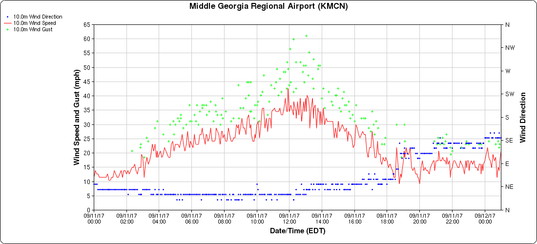
This graph shows wind direction and wind speed/gusts in miles per hour at Middle Georgia Regional Airport in Macon. (Courtesy MesoWest, University of Utah) Note the frequent wind gusts between 50 and 65 mph. Click the graph to enlarge it. |
 |
|
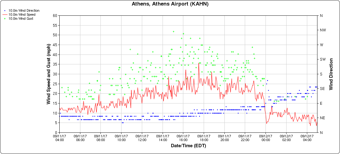
This graph shows wind direction and wind speed/gusts in miles per hour at the Athens Airport. (Courtesy MesoWest, University of Utah) Note the high wind gusts over 50 mph. Click the graph to enlarge it. |
 |
|
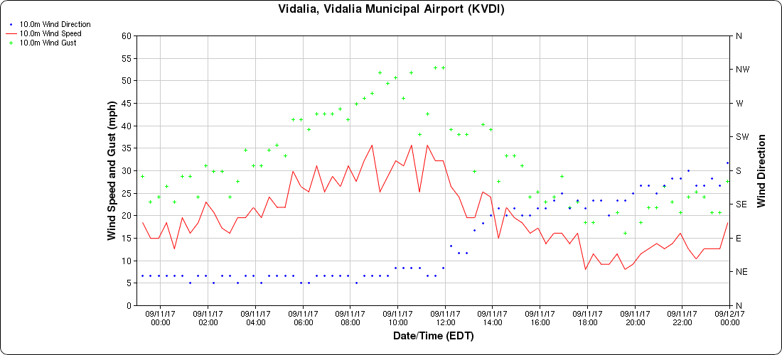
This graph shows wind direction and wind speed/gusts in miles per hour at the Vidalia airport. (Courtesy MesoWest, University of Utah) Note the high wind gusts over 50 mph. Click the graph to enlarge it. |
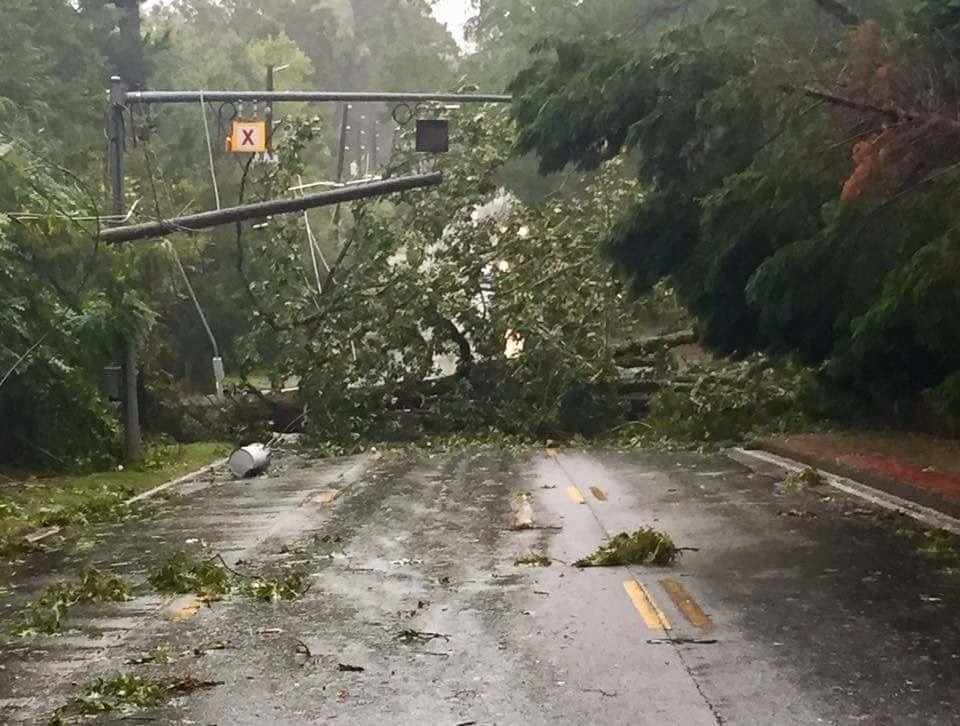
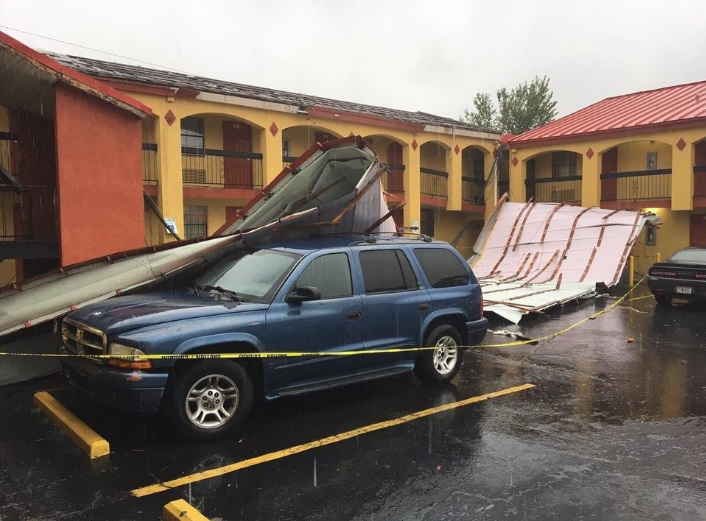
Wind Damage Photos:
|
|
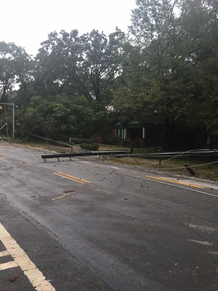 |
| One large tree pulled down power lines as it fell across Memorial Drive in Atlanta, while another large tree on the right side of the roadway was also blown down. | This utility pole was pulled down on Memorial Drive in Atlanta. |
|
|
 |
| Part of the roof was removed from this motel in College Park. (Courtesy WSB-TV) |
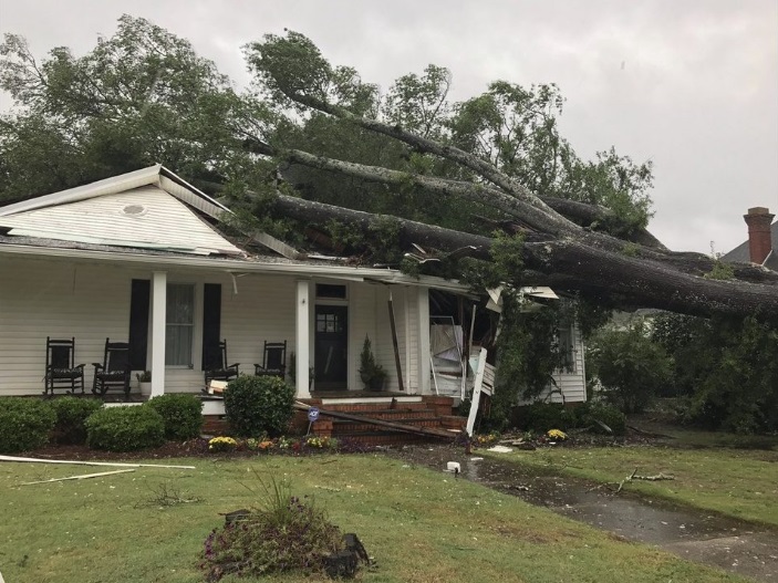
This large tree fell onto a home in McDonough. (Courtesy WSB-TV) |
 |
|
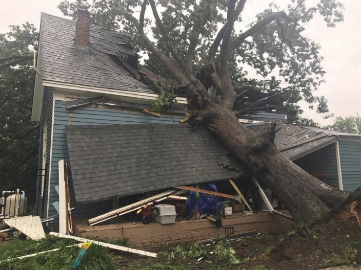
This huge tree fell onto a home in Commerce. (Courtesy WSB-TV) |
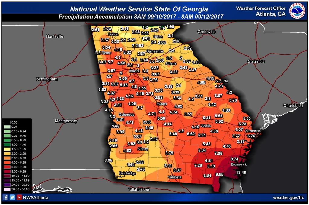
The heaviest rainfall totals were confined to far southeast Georgia, outside of the local forecast and warning area. In our local region, the highest rainfall totals were around 5 inches. Since the conditions immediately leading up to the passage of Irma were mostly dry, primarily minor flooding issues were experienced.
 |
|
This map displays rainfall accumulation from 8 AM 9/10/17 - 8 AM 9/12/17. (Click the map to enlarge it.) |
Why Weren't There Any Tornadoes?:
Despite the fact that much of the area was on the side of Irma typically favorable for tornadoes, no tornadoes were recorded across the state during Irma's passage. The primary reason for this lack of tornadoes was the fact that an unseasonably cool and stable air mass was in place across the area. In fact, high temperatures were only in the 60s that day, which set record cool high temperatures for September 11th for many locations. These cool temperatures eliminated any instability that would have supported tornado-producing tropical convection associated with Irma.