2020 Easter Tornado Outbreak
Updates will be made to this page as new information allows.
[Overview]
Tornadoes of April 12-13:
(in chronological order by county)
Overview:
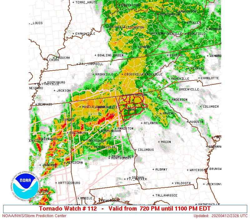
A powerful storm system brought a widespread severe weather outbreak across the South which began Easter morning across the ArkLaTex region and spread eastward through the day. Very high levels of wind shear and favorable instability built across Georgia by Sunday evening ahead of this powerful storm system. As the storms moved across Georgia from Sunday evening through early Monday morning, numerous tornadoes touched down and widespread thunderstorm wind damage brought down trees and power lines. As of this writing, 21 tornadoes had been confirmed across the NWS Atlanta forecast area, including two EF-3 tornadoes.
|
|
 |
|
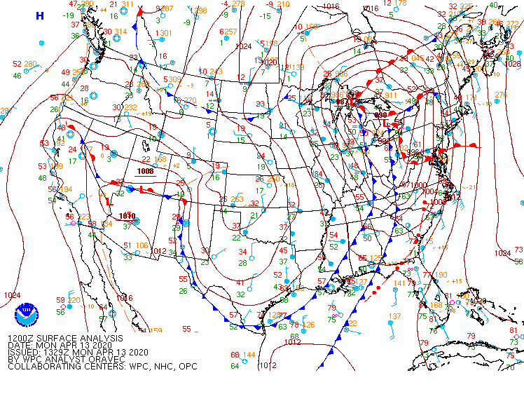
| Surface map (Apr. 12, 8 pm) |
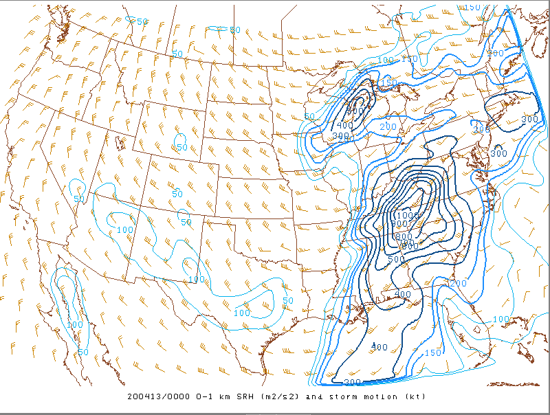
0-1 km storm relative helicity (SRH) map (Apr. 12, 8 pm)
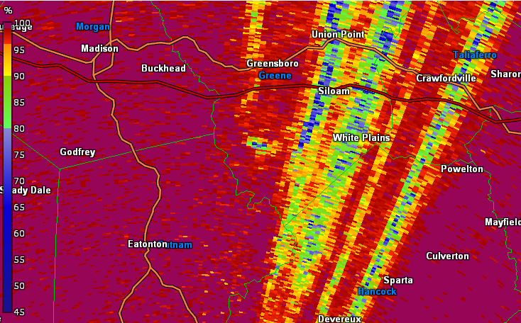
Extremely high values of SRH led to the formation of numerous tornadoes.
|
|
|
 |
|
|
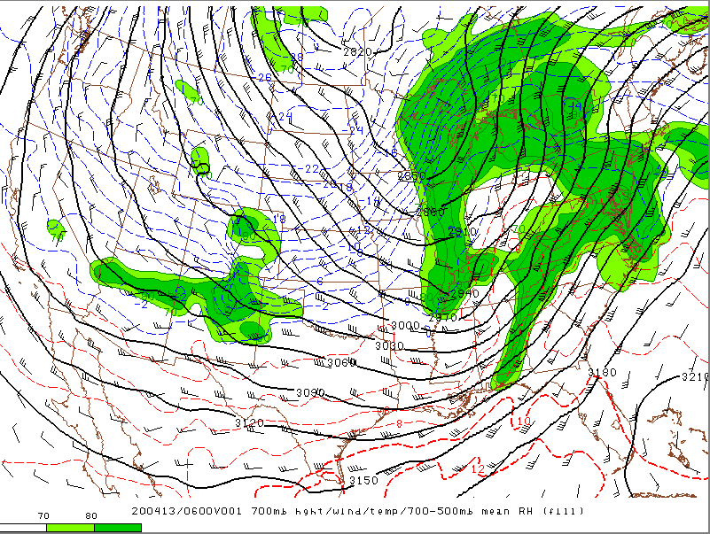
700 mb height/wind/temp (Apr. 12, 2 am)
|
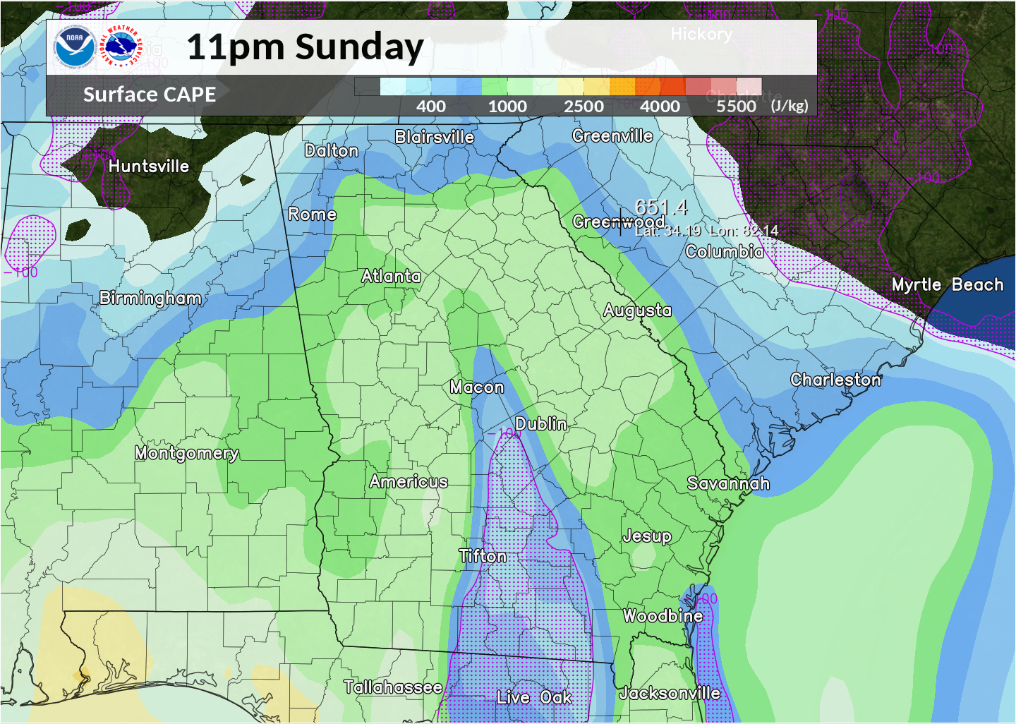
Analyzed surface CAPE (Apr. 12, 11 pm)
A warm front lifted northward across the state Sunday afternoon, bringing plentiful instability by Sunday evening.
|
|
|

|
|
Tornado watch from the evening of Apr. 12 with the first round of storms.
|
Tornado Watch from the early morning hours of Apr. 13. |
|

|
|
|
Tornado and Severe Thunderstorm Warnings that were issued.
|
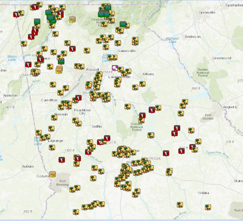
Storm damage reports across north and central Georgia. |
|
|
|
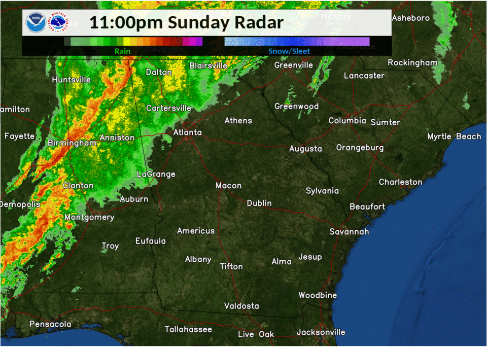
Numerous severe thunderstorms tracked across the state beginning in the evening hours on April 12th through the early morning hours on April 13th.
|
Tornadoes:
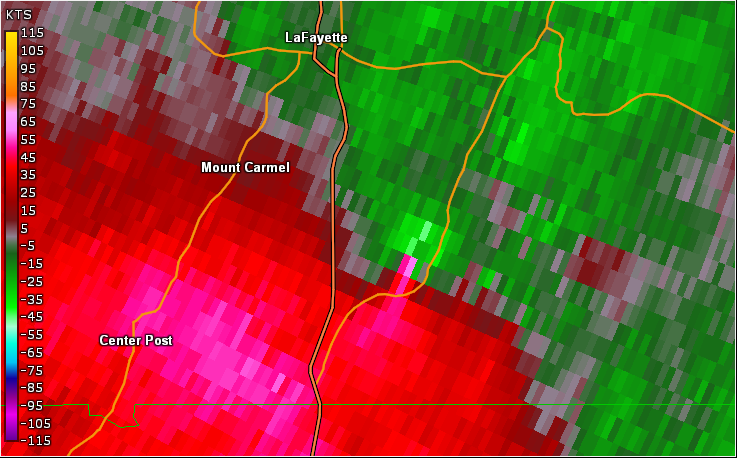
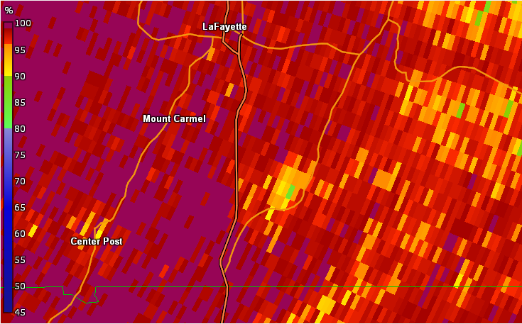
1) Chattooga and Walker County Tornado:
This tornado began just north of Summerville where multiple trees were snapped and uprooted. Near Orchard Hill Road more notable damage occurred when a 10K pound camper was overturned and shingles/siding was torn from nearby houses. The tree damage continued along the tornado path before the tornado crossed into Walker county. Additional tree damage was reported just over the county line with a TDS seen from the Hytop radar. A two story house was damaged when the second story and roof were removed. In addition, a Jeep was thrown more than 50 yards from its original location. When the tornado was its strongest, at 120-125 mph, multiple other houses were damaged. The tornado quickly weakened and lifted southeast of the town of LaFayette.
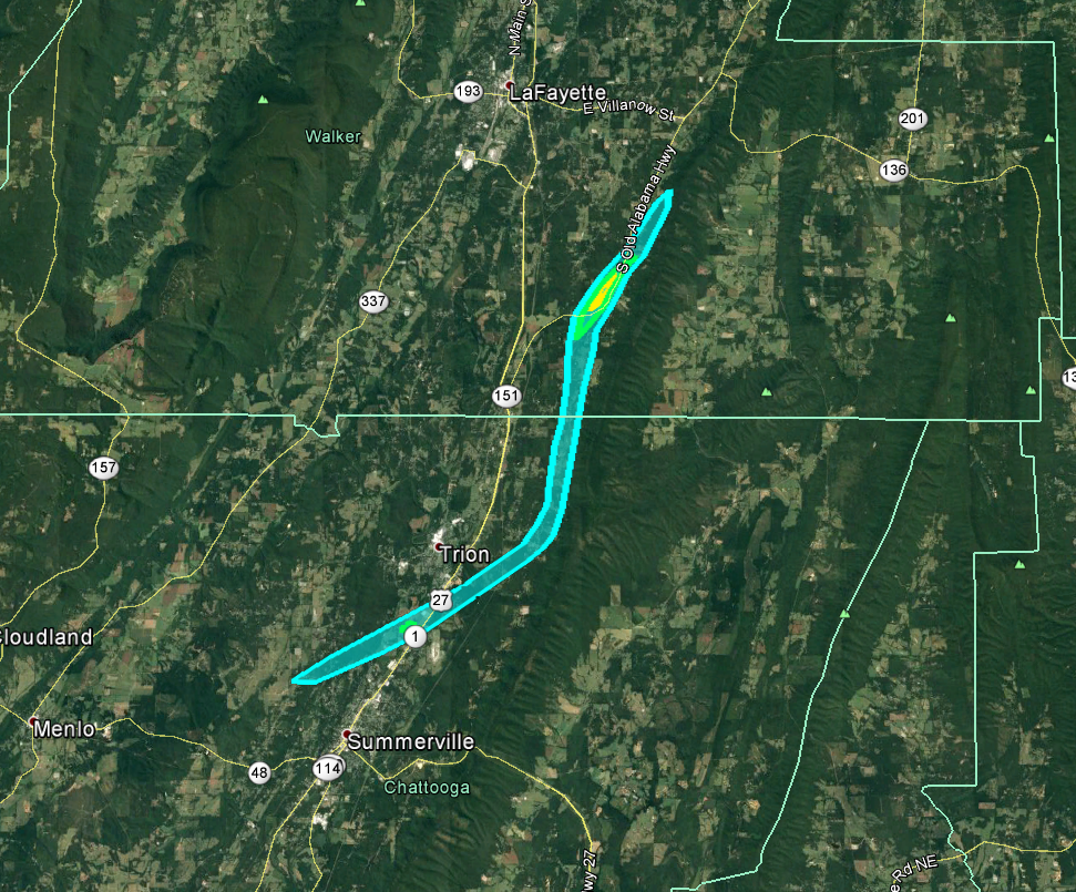 |
| Damage Path - Chattooga and Walker County |
|
| County |
Rating |
# of Injuries |
KML |
| Chattooga/Walker |
EF-2 |
0 |
 |
|
| Rating: |
EF-2 |
| Peak Wind: |
125 MPH |
| Path Length: |
15.8 miles |
| Path Width: |
880 yards |
| Fatalities: |
0 |
| Injuries: |
0 |
| Start Date: |
Apr. 12, 2020 |
| Start Time: |
8:15 PM EDT |
| Start Location: |
1.8 NW miles of Summerville (Chatooga Co) |
| Start Lat/Lon: |
34.4990 / -85.3689 |
| End Date: |
Apr. 12, 2020 |
| End Time: |
8:32 PM EDT |
| End Location: |
4.2 miles SE of LaFayette (Walker Co) |
| End Lat/Lon: |
34.6660 / -85.2150 |
|
|
|

|
|
| This house suffered major structural damage from the tornado near Alabama Road. |
The tornado also caused major structural damage to this home near Alabama Road. |
- Back to Top -
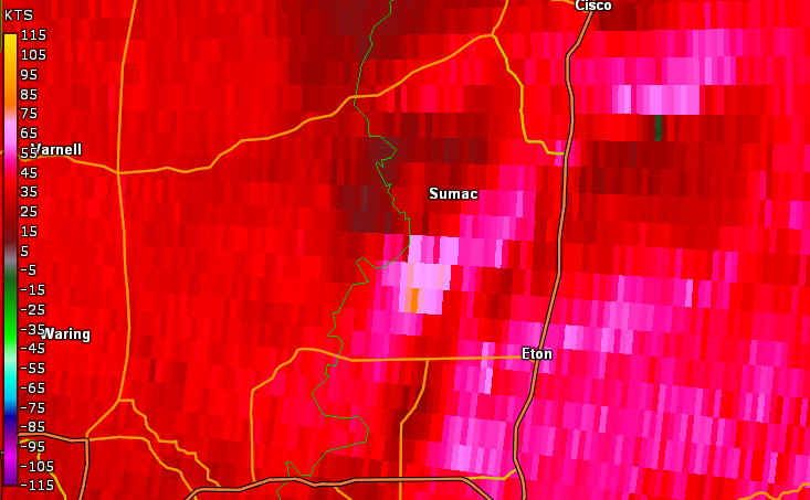
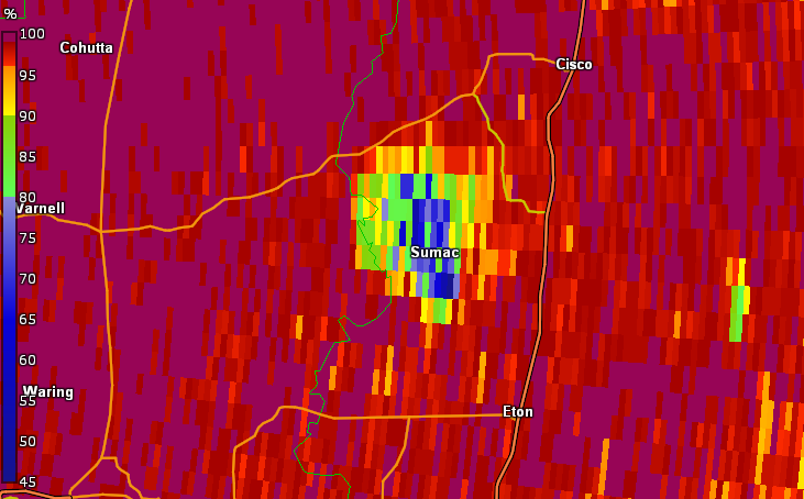
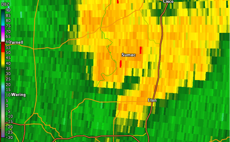
2) Murray Tornado:
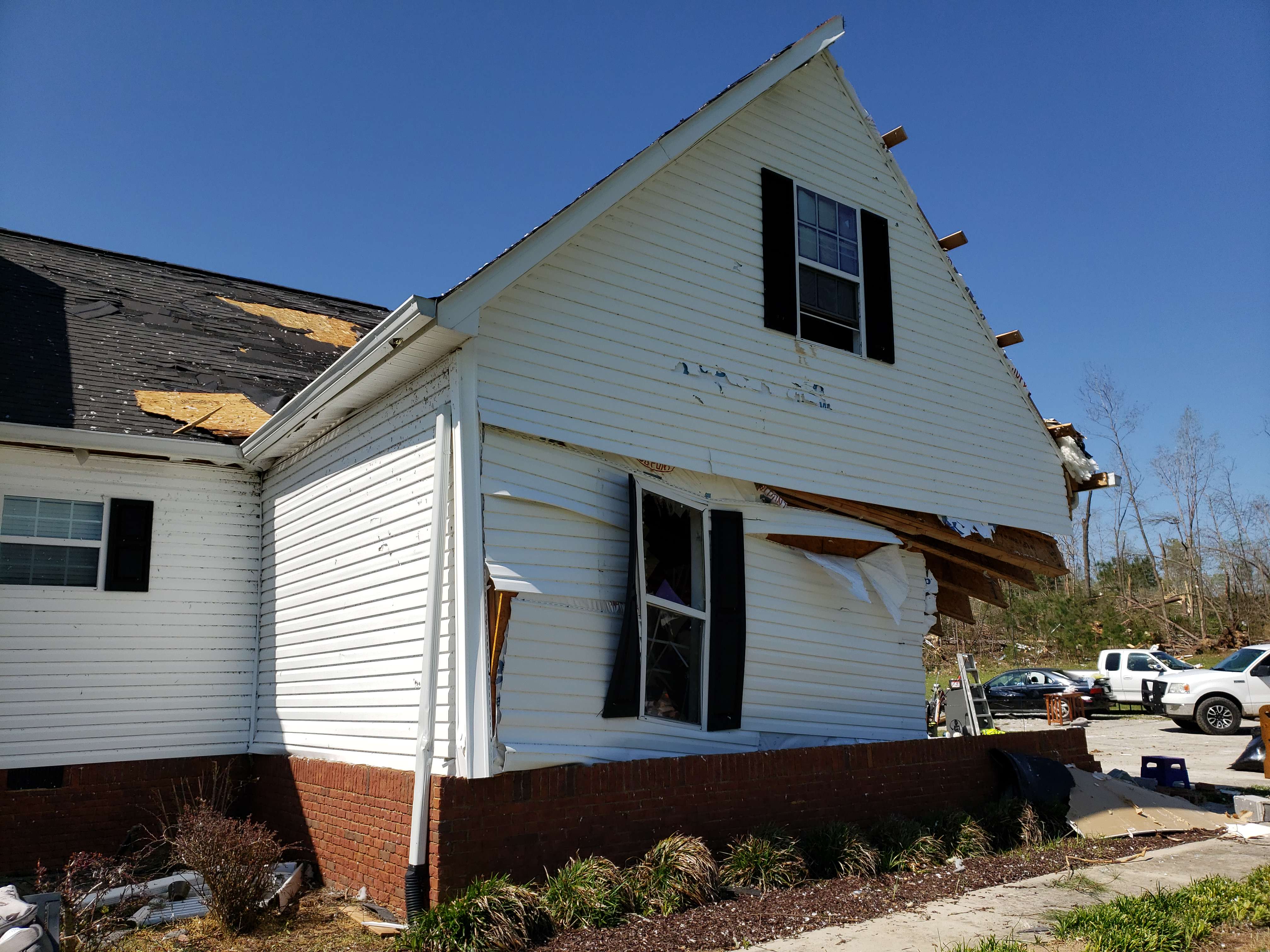
This tornado touched down in west-central Murray county where several trees were snapped/uprooted. Some minor structural damage also occurred shortly after the tornado formed. At the tornadoes highest intensity, EF-2 with max winds around 125 mph, at least 8 double-wide manufactured homes were destroyed along Deer Park Drive, with additional manufactured home destroyed in the areas of Ridgeview Lane and Fieldview Court. A cell tower was also crumpled in the strong winds. As the tornado continued, extensive damage was reported to several more homes and large chicken houses, with one completely destroyed. Before the tornado lifted, more tree damage occurred with roof damage to a shed.
 |
| Damage Path - Murray County |
|
| County |
Rating |
# of Fatalities/Injuries |
KML |
| Murray |
EF-2 |
7 Fatalities,
Unknown Injuries
|
|
|
| Rating: |
EF-2 |
| Peak Wind: |
135 MPH |
| Path Length: |
7.8 miles |
| Path Width: |
860 yards |
| Fatalities: |
7 |
| Injuries: |
Unknown |
| Start Date: |
Apr. 12, 2020 |
| Start Time: |
9:45 PM EDT |
| Start Location: |
4.3 miles NW of Chatsworth |
| Start Lat/Lon: |
34.8098 / -84.8377 |
| End Date: |
Apr. 12, 2020 |
| End Time: |
9:55 PM EDT |
| End Location: |
3.6 miles SSW of Cisco |
| End Lat/Lon: |
34.9103 / -84.7761 |
|
|
|
 This home was destroyed on Deer Park Drive. This home was destroyed on Deer Park Drive.
|
|

|
 |
| Extensive damage occurred to this mobile home as it was flipped off its foundation on Deer Park Drive. |
This home was destroyed along Ridge View Lane. |
- Back to Top -
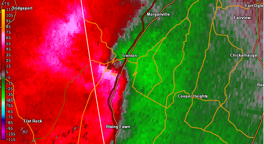
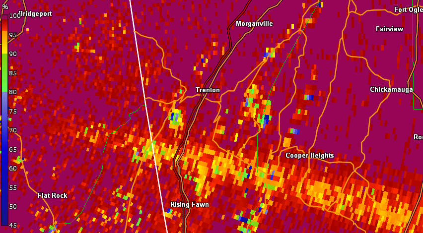
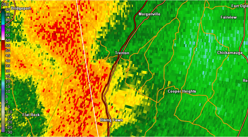
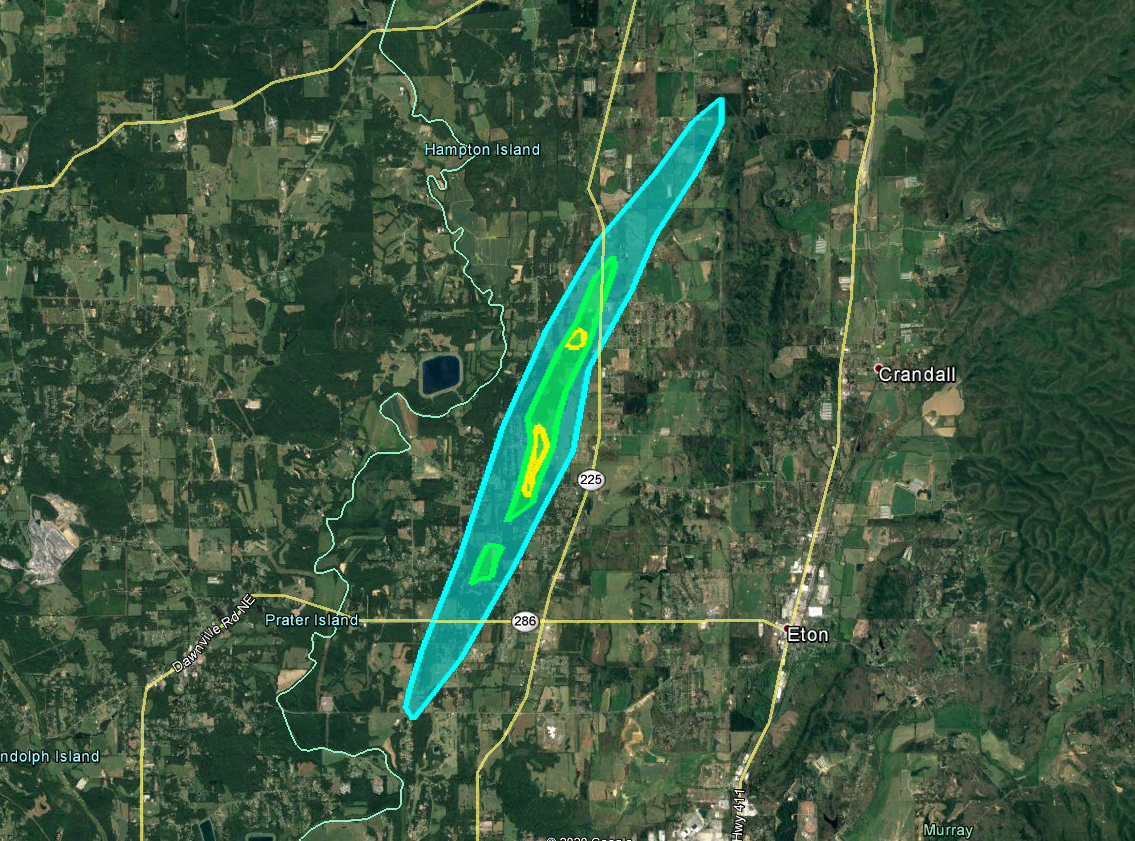
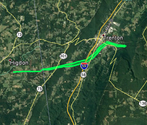
3) Dade County Tornado:
An EF-1 tornado touched down near the town of Higdon in Dekalb County, AL and traveled almost 2 miles before crossing the state border into Georgia. Right at the state border numerous trees were downed along Michael Road and Brown Gap Cemetery Road. Most notably this tornado blew the pillars from the front of a home and also flipped an RV, destroying the vehicle. In addition, several houses were reported to have trees fallen on them or on the property. The tornado continued northeast towards damaging, snapping, and uprooting many trees near the Trenton Golf Club property. After additional tree damage along Canyon park drive, the tornado finally lifted to the SE of the city of Trenton. For more information on the tornado when it was in Alabama, please see the Public Information Statement from NWS Huntsville.
 |
| Damage Path - Dade County |
|
| County |
Rating |
# of Injuries |
KML |
| Dade |
EF-1 |
0 |
|
|
| Rating: |
EF-1 |
| Peak Wind: |
100 MPH |
| Path Length: |
5.6 miles |
| Path Width: |
350 yards |
| Fatalities: |
0 |
| Injuries: |
0 |
| Start Date: |
Apr. 12, 2020 |
| Start Time: |
10:54 PM EDT |
| Start Location: |
4.8 miles SW of Trenton |
| Start Lat/Lon: |
34.8372 / -85.5784 |
| End Date: |
Apr. 12, 2020 |
| End Time: |
11:05 PM EDT |
| End Location: |
1.6 miles SSE of Trenton |
| End Lat/Lon: |
34.8621 / -85.4851 |
|
|
|
|
 |
| The tornado broke the pillars and damaged the roof of this home on Michaels Road. |
This RV was flipped and destroyed near Glenview Drive. |
- Back to Top -
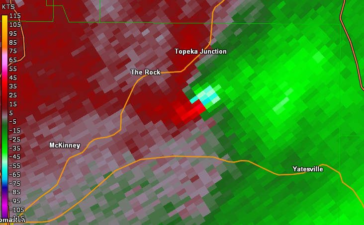
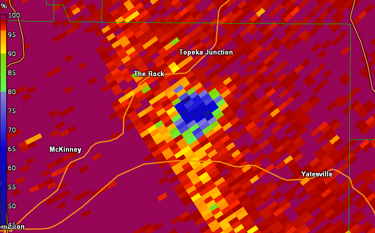
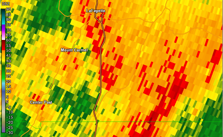
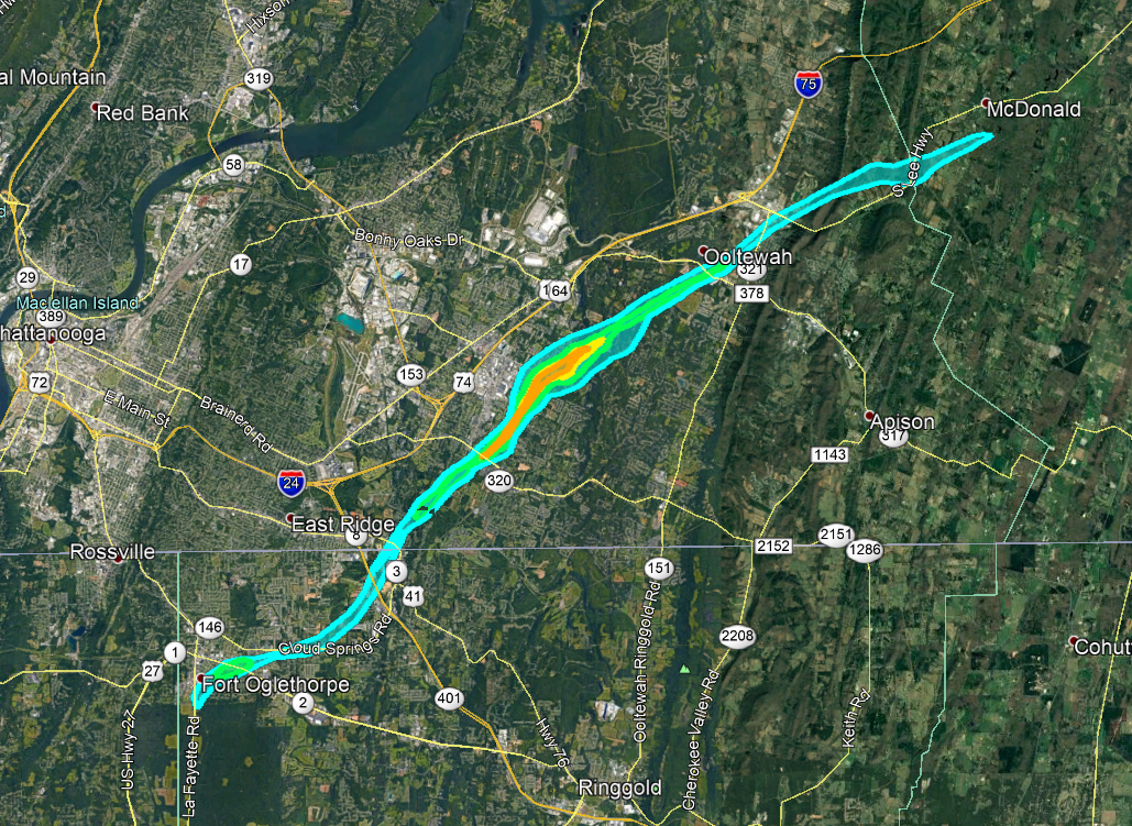
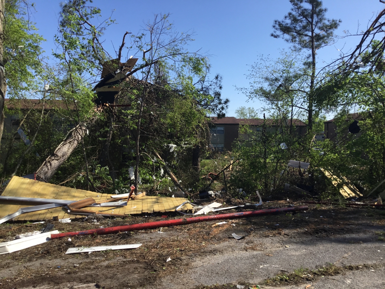
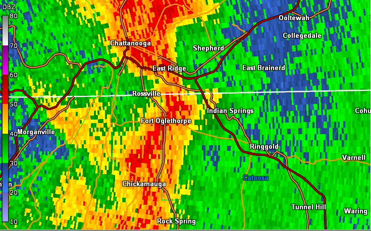
4) Catoosa County/Hamilton County (TN) Tornado:
This tornado initially began near the city of Fort Oglethorpe near the Chickamauga Battlefield Visitor Center where several trees were snapped. The tornado quickly strengthened quickly as it traveled along Battlefield Parkway, damaging several buildings including extensive damage to a metal building. In addition, the weather station at the Public Works Department in Fort Oglethorpe measured a wind gust of 106 mph. As the tornado moved northeast it continues to cause tree damage as well as damage to several homes. The tornado then continued into Tennessee. For more information on the tornado once it tracked into Tennessee, please see our latest Public Information Statement.
 |
| Damage Path - Catoosa County |
|
| County |
Rating |
# of Injuries |
KML |
| Catoosa |
EF-3 |
3 Fatalities,
19 Injuries
|
|
|
| Rating: |
EF-3 |
| Peak Wind: |
145 MPH |
| Path Length: |
20.0 miles |
| Path Width: |
1500 yards |
| Fatalities: |
3 |
| Injuries: |
19 |
| Start Date: |
Apr. 12, 2020 |
| Start Time: |
11:15 PM EDT |
| Start Location: |
Fort Oglethorpe (Catoosa Co) |
| Start Lat/Lon: |
34.9407 / -85.2582 |
| End Date: |
Apr. 12, 2020 |
| End Time: |
11:33 PM EDT |
| End Location: |
5.3 miles NE of Ooltewah (Bradley Co, TN)
|
| End Lat/Lon: |
35.1040 / -84.9816 |
|
|
|
 This car wash was destroyed on Battlefield Parkway. This car wash was destroyed on Battlefield Parkway.
|
|

|
 |
| This paint store sustained extensive damage from the tornado on Battlefield Parkway. |
Debris from surrounding areas was scattered along Battlefield Parkway. |
|
|
 |
| Reflectivity (11:18 PM EDT). |
Velocity (11:18 PM EDT). |
- Back to Top -
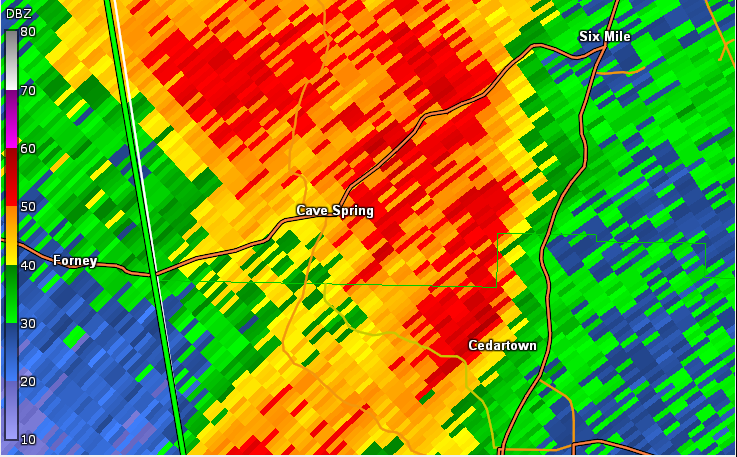
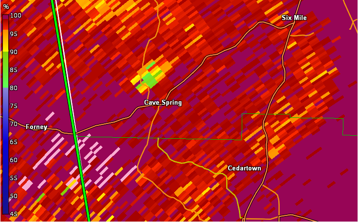
5) Floyd County Tornado #1:
A brief, weak tornado formed over southwest Floyd county, downing several trees in a wooded area. No impacts to structures were reported or observed.
 |
| Damage Path - Floyd County |
|
| County |
Rating |
# of Injuries |
KML |
| Floyd |
EF-0 |
0 |
|
|
| Rating: |
EF-0 |
| Peak Wind: |
70 MPH |
| Path Length: |
.5 miles |
| Path Width: |
50 yards |
| Fatalities: |
0 |
| Injuries: |
0 |
| Start Date: |
Apr. 13, 2020 |
| Start Time: |
12:31 AM EDT |
| Start Location: |
2 miles WNW of Cave Spring |
| Start Lat/Lon: |
34.1239 / -85.3675 |
| End Date: |
Apr. 13, 2020 |
| End Time: |
12:31 AM EDT |
| End Location: |
2 miles WNW of Cave Spring |
| End Lat/Lon: |
34.1244 / -85.3653 |
|
|
- Back to Top -
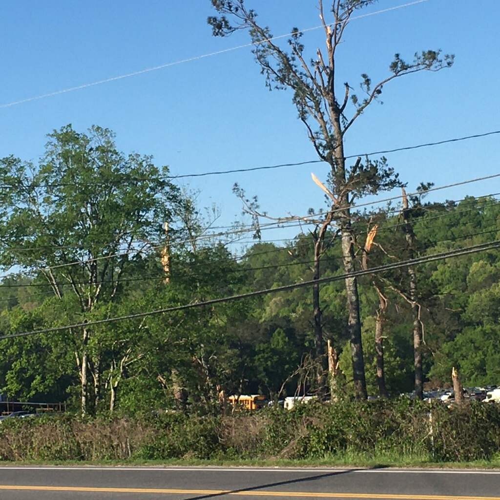
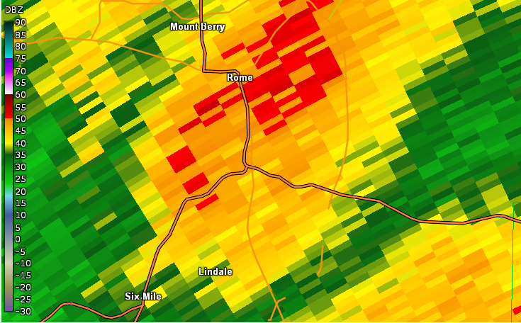
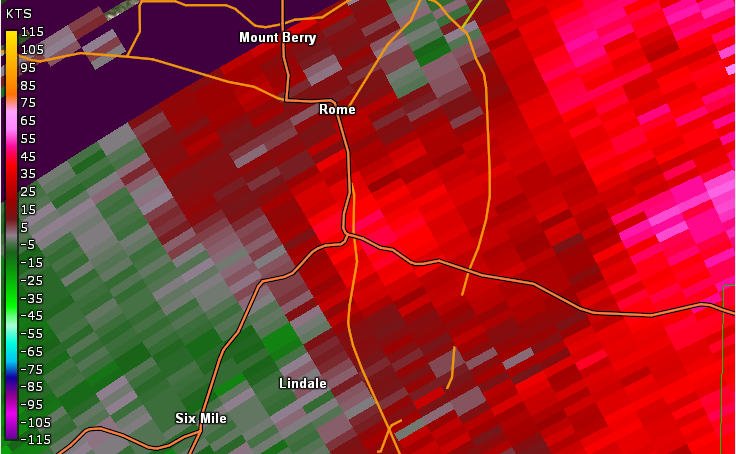
6) Floyd County Tornado #2:
This tornado began near Lindale and was spawned from the same storm that produced the tornado in southwest Floyd County. The tornado traveled for 3 miles resulting in spotty areas of tree damage closing roads and causing some power outages. As the tornado continued north-northeast about a dozen small trees were snapped at the 3100 block of Rockmart road. The tornado lifted a few minutes later and.
 |
| Damage Path - Floyd County |
|
| County |
Rating |
# of Injuries |
KML |
| Floyd |
EF-0 |
0 |
|
|
| Rating: |
EF-0 |
| Peak Wind: |
80 MPH |
| Path Length: |
3.2 miles |
| Path Width: |
50 yards |
| Fatalities: |
0 |
| Injuries: |
0 |
| Start Date: |
Apr. 13, 2020 |
| Start Time: |
12:42 AM EDT |
| Start Location: |
.4 miles N of Lindale |
| Start Lat/Lon: |
34.1924 / -85.1735 |
| End Date: |
Apr. 13, 2020 |
| End Time: |
12:45 AM EDT |
| End Location: |
1.6 miles SE of Rome |
| End Lat/Lon: |
34.2311 / -85.1424 |
|
|
|
|
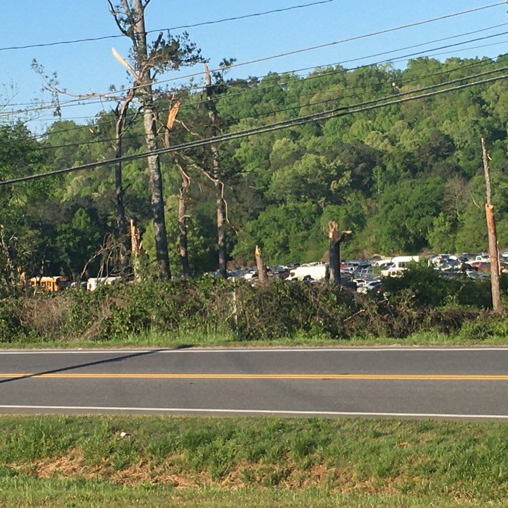 |
| Multiple trees were snapped by the tornado. |
Additional trees were snapped by the tornado. |
|
|
 |
| Reflectivity (4:43 AM EDT). |
Velocity (4:43 AM EDT). |
|
- Back to Top -
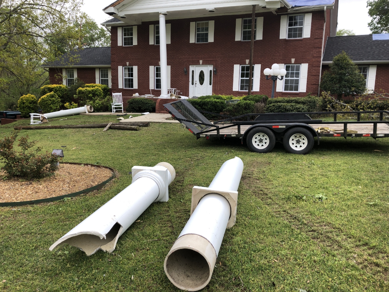
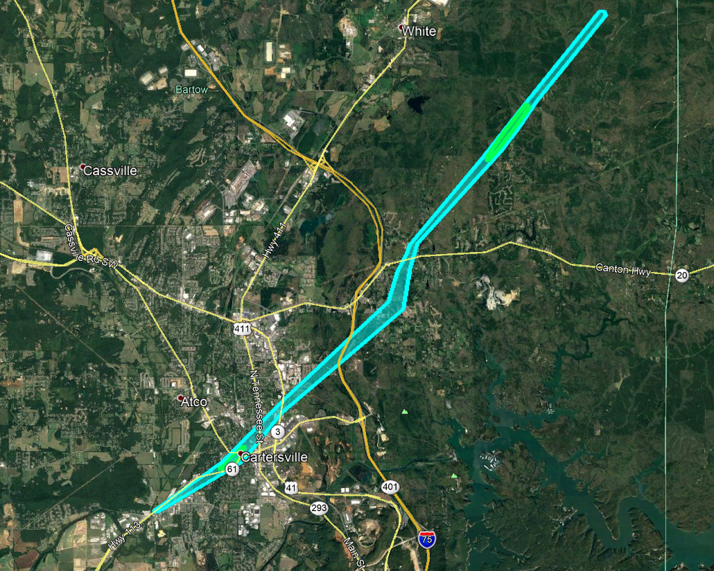
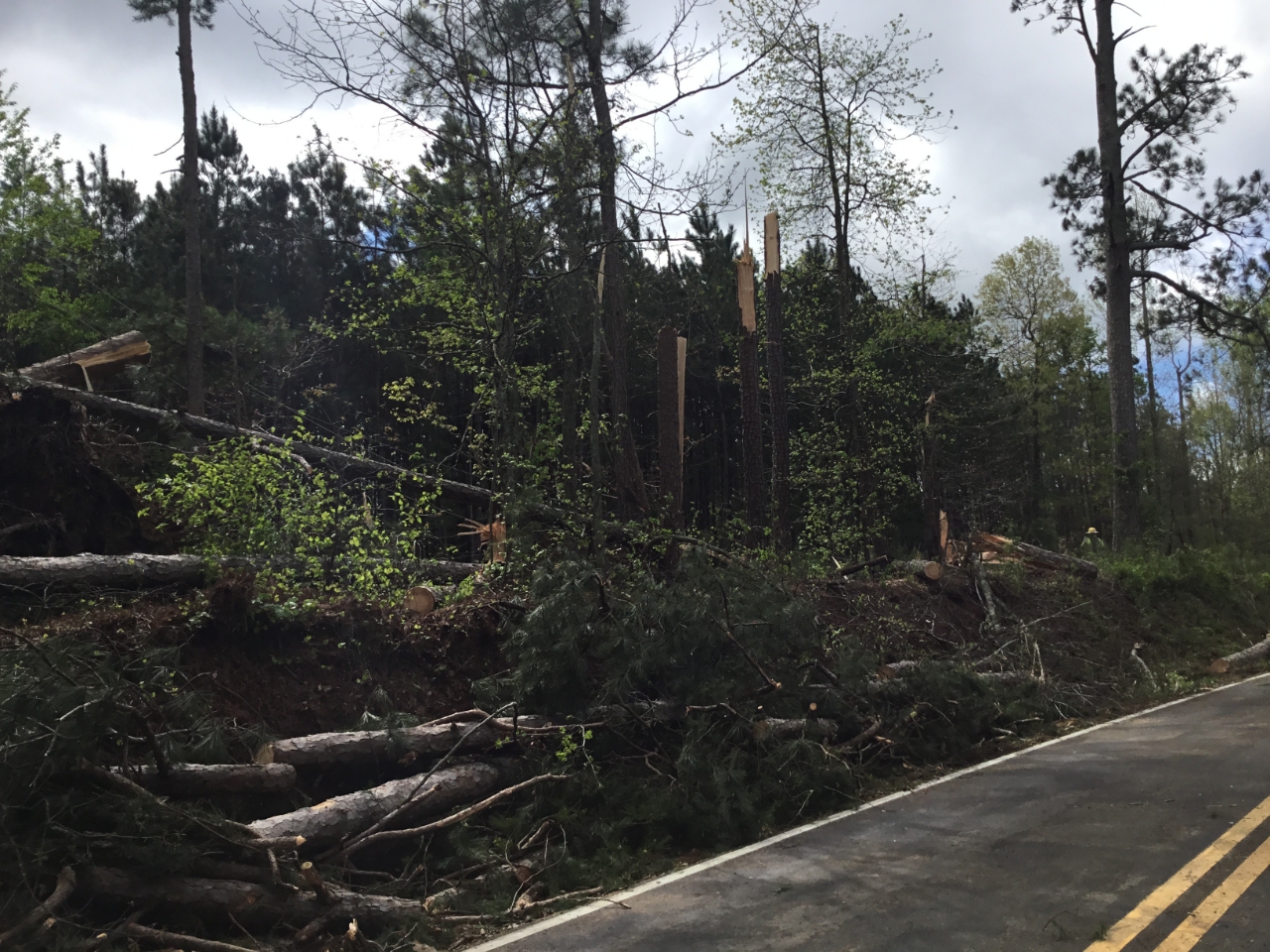
7) Bartow County Tornado:
An EF-1 tornado touched down in Bartow County to the southwest of Cartersville along West Avenue (Route 113) where a fence was blown down and roofing material was peeled at a small business. The tornado continued northeast along West Avenue with sporadic damage to trees before entering the southwest side of Cartersville, downing trees on Cedar Lane. A very large oak tree was downed along Herring and Fite Street onto a home, killing a 34-year old male who was asleep in the bedroom hit by the large tree. The tornado continued northeast, downing trees along Bartow Street and West Cherokee Avenue in addition to other areas across downtown Cartersville. The tornado continued northeast through downtown with mostly EF-0 tree damage. The tornado crossed I-75 and GA 294/20 spur, downing a few trees and onto Dean Road. The tornado intensified as it crossed Highway 20 east of I-75. Numerous. Numerous trees were downed near the end of Black Road NE with some minor roof damage to a home. Bells Ferry Road also had numerous large trees snapped and downed across it. The tornado reached maximum intensity in this area. The storm crossed Stamp Creek Road, downing trees and powerlines, before entering the Pine Log Wildlife Management Area. According to Wildlife Management Personnel, at least 60-70 more trees were downed here before the tornado lifted. The storm eventually regenerated a new tornado in Cherokee County.
 |
| Damage Path - Bartow County |
|
| County |
Rating |
# of Injuries |
KML |
| Bartow |
EF-1 |
|
|
|
| Rating: |
EF-1 |
| Peak Wind: |
100 MPH |
| Path Length: |
13 miles |
| Path Width: |
250 yards |
| Fatalities: |
1 |
| Injuries: |
2 |
| Start Date: |
Apr. 12, 2020 |
| Start Time: |
1:06 AM EDT |
| Start Location: |
2 miles WSW of Cartersville |
| Start Lat/Lon: |
34.1492 / -85.8285 |
| End Date: |
Apr. 12, 2020 |
| End Time: |
1:21 AM EDT |
| End Location: |
4 miles E of White |
| End Lat/Lon: |
34.2857 / -85.6780 |
|
|
|
|
 |
| Multiple trees were snapped along Bells Ferry Road. |
This tree fell on a home on Herring Street. |
|

|
 |
| Reflectivity (1:09 AM EDT). |
Velocity (1:09 AM EDT). |
- Back to Top -
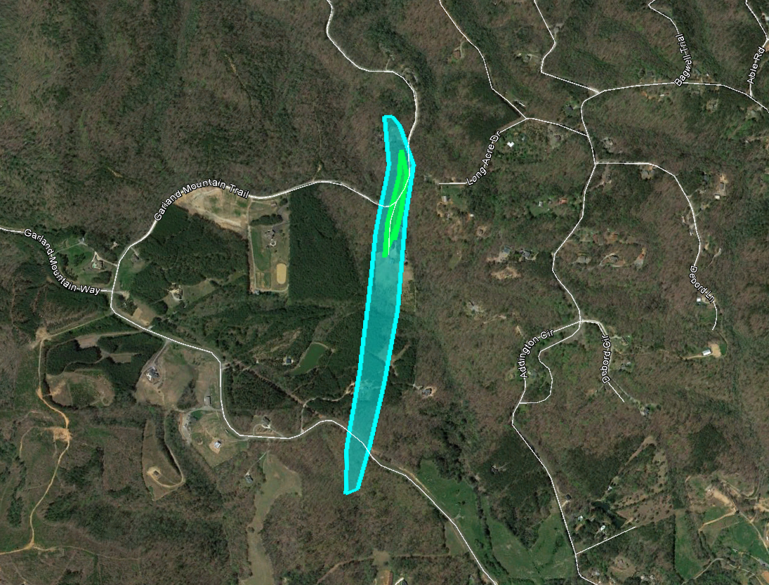
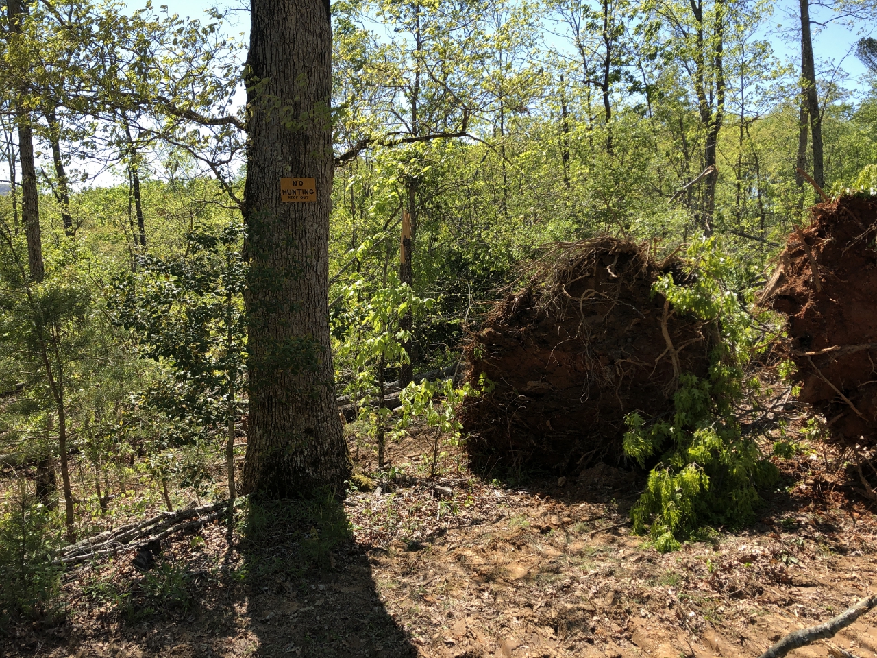
8) Cherokee County Tornado:
Although this EF-1 tornado traveled for less than 1 mile, the 90 mph winds downs a path of 250 to 300 trees and blocked Garland Mountain Trail in several places.
 |
| Damage Path - Cherokee County |
|
| County |
Rating |
# of Injuries |
KML |
| Cherokee |
EF-1 |
0 |
|
|
| Rating: |
EF-1 |
| Peak Wind: |
90 MPH |
| Path Length: |
.7 miles |
| Path Width: |
100 yards |
| Fatalities: |
0 |
| Injuries: |
0 |
| Start Date: |
Apr. 13, 2020 |
| Start Time: |
1:32 AM EDT |
| Start Location: |
2 miles SSW of Salacoa Valley |
| Start Lat/Lon: |
34.3524 / -84.6028 |
| End Date: |
Apr. 13, 2020 |
| End Time: |
1:33 AM EDT |
| End Location: |
2 miles SSW of Salacoa Valley |
| End Lat/Lon: |
34.3626 / -84.6013 |
|
|
|
|
 |
| The tornado snapped and uprooted several trees along Garland Mountain Trail. |
The tornado snapped and uprooted several trees along Garland Mountain Trail. |
- Back to Top -
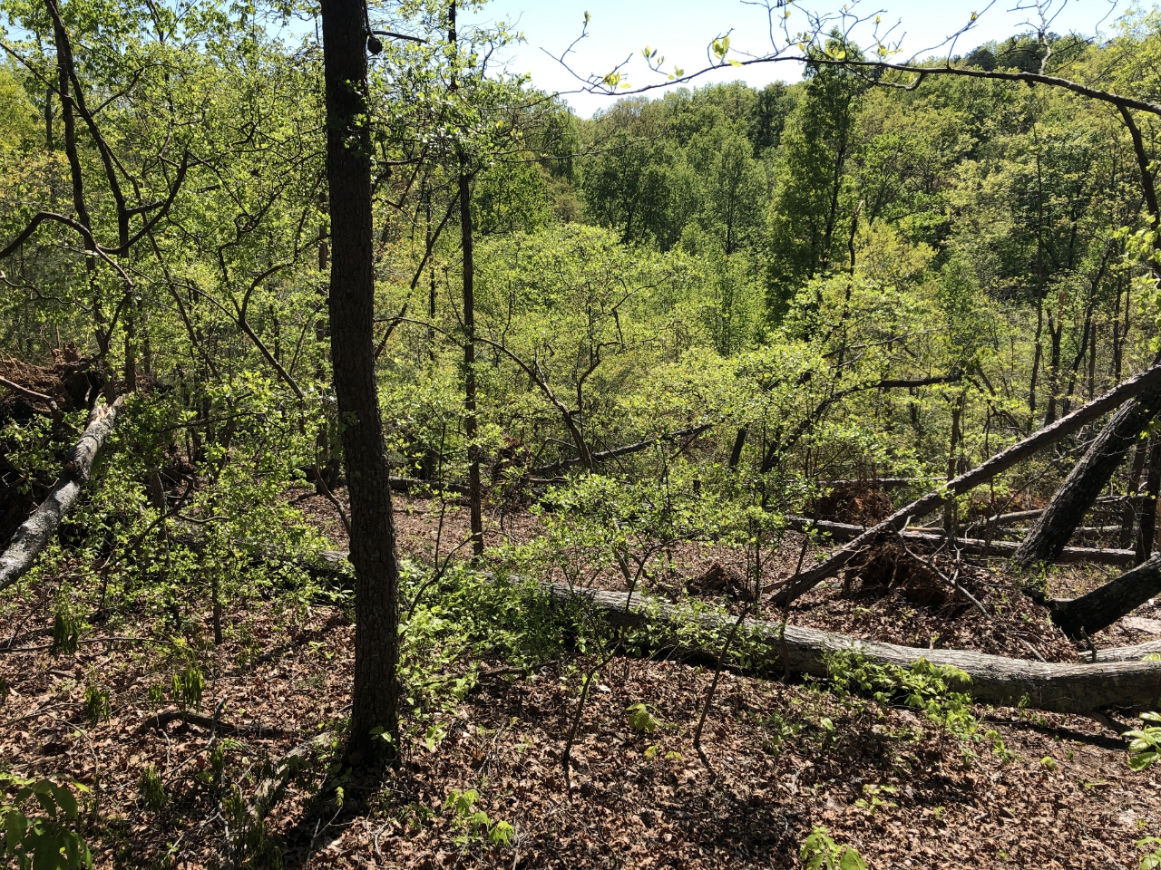
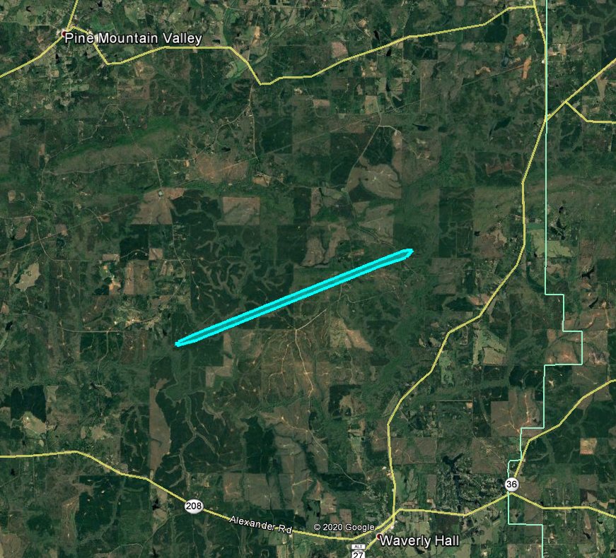
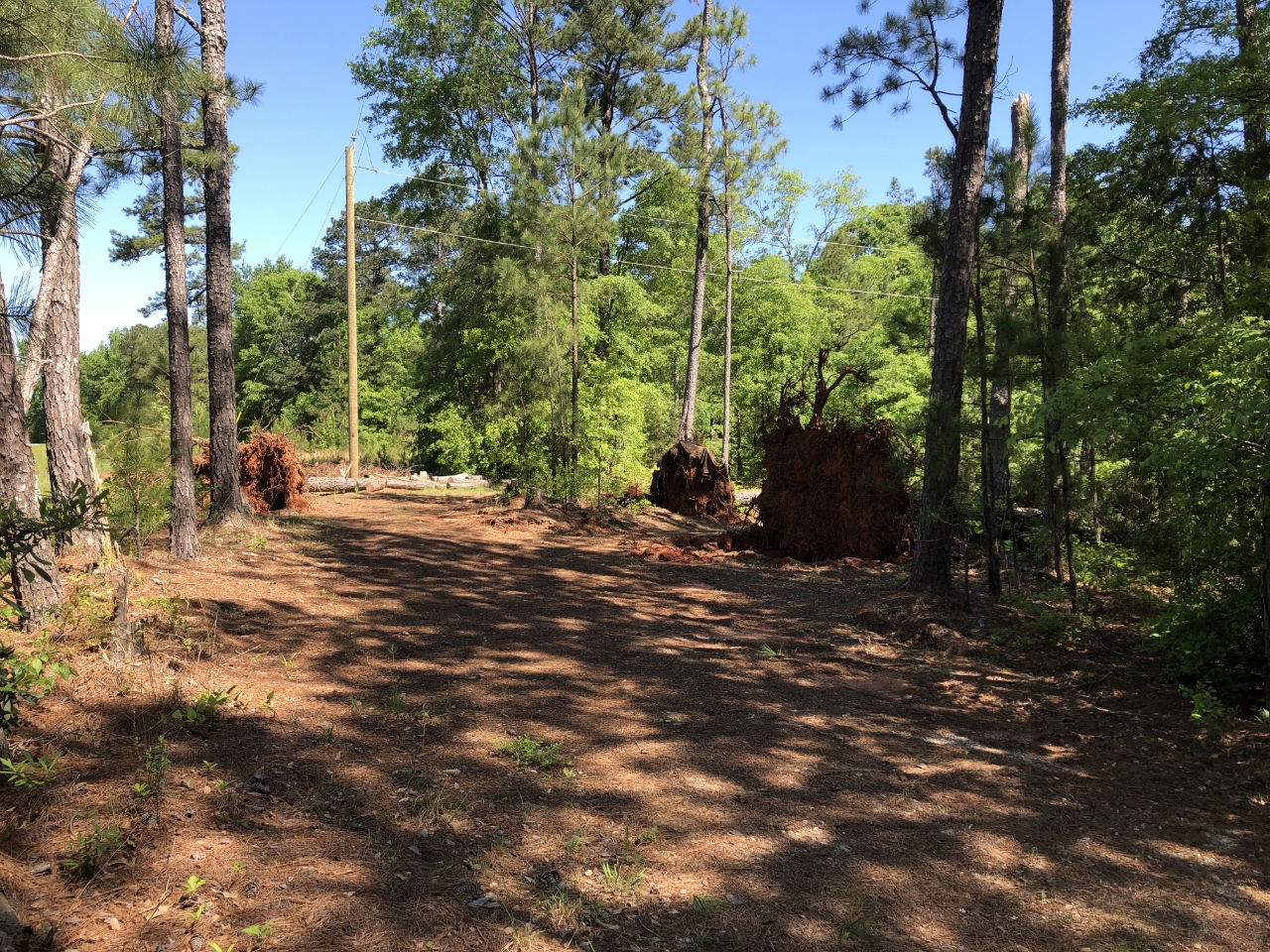
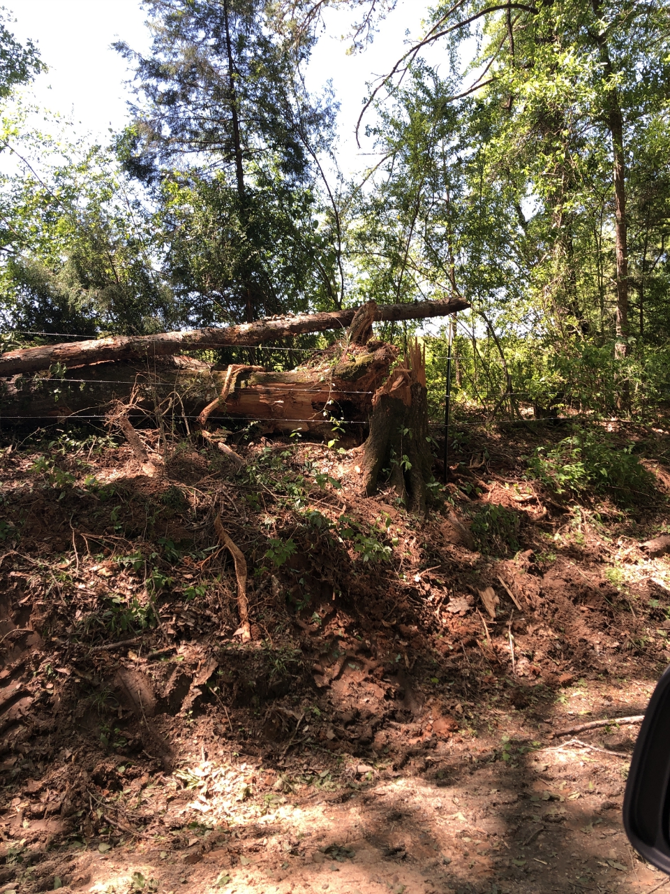
9) Harris County Tornado:
A brief, weak tornado developed over eastern Harris county downing several trees in a remote wooded area.
 |
| Damage Path - Harris County |
|
| County |
Rating |
# of Injuries |
KML |
| Harris |
EF-0 |
0 |
|
|
| Rating: |
EF-0 |
| Peak Wind: |
80 MPH |
| Path Length: |
3.0 miles |
| Path Width: |
50 yards |
| Fatalities: |
0 |
| Injuries: |
0 |
| Start Date: |
Apr. 13, 2020 |
| Start Time: |
1:53 AM EDT |
| Start Location: |
4 miles NW of Waverly Hall |
| Start Lat/Lon: |
32.7279 / -84.7924 |
| End Date: |
Apr. 13, 2020 |
| End Time: |
1:55 AM EDT |
| End Location: |
4 miles NW of Waverly Hall |
| End Lat/Lon: |
32.7476 / -84.7321 |
|
|
|
|
| Several trees were uprooted along Oak Mountain Road. |
|
|
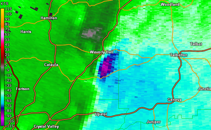 |
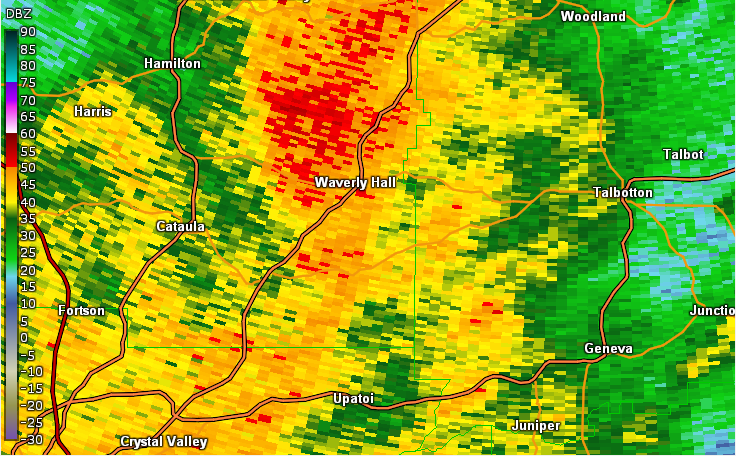
| Reflectivity (4:01 AM EDT). |
Velocity (4:01 AM EDT). |
- Back to Top -
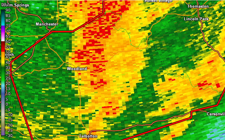
10) Talbot County Tornado:
A brief, weak tornado developed over northern Talbot County downing several trees in a remote wooded area. In addition the tornado downed several trees which blocked roadways.
 |
| Damage Path - Talbot County |
|
| County |
Rating |
# of Injuries |
KML |
| Talbot |
EF-0 |
0 |
|
|
| Rating: |
EF-0 |
| Peak Wind: |
80 MPH |
| Path Length: |
2.9 miles |
| Path Width: |
100 yards |
| Fatalities: |
0 |
| Injuries: |
0 |
| Start Date: |
Apr. 13, 2020 |
| Start Time: |
2:08 AM EDT |
| Start Location: |
4 miles SE of Woodland |
| Start Lat/Lon: |
32.7516 / -84.5144 |
| End Date: |
Apr. 13, 2020 |
| End Time: |
2:10 AM EDT |
| End Location: |
2 miles SE of Pleasant Hill |
| End Lat/Lon: |
32.7794/ -84.4762 |
|
|
|
|
| Several trees were snapped and uprooted along Tom Buffington Road. |
|
|
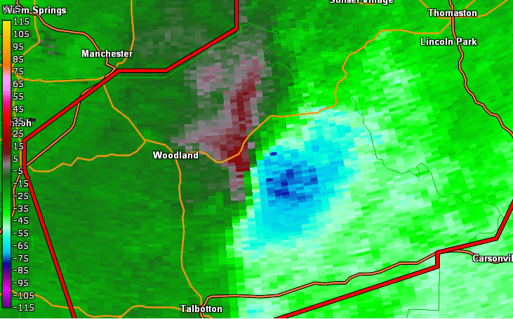 |
| Reflectivity (2:08 AM EDT). |
Velocity (2:08 AM EDT). |
|
- Back to Top -
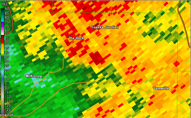
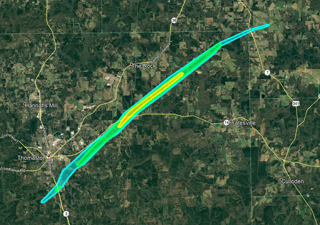
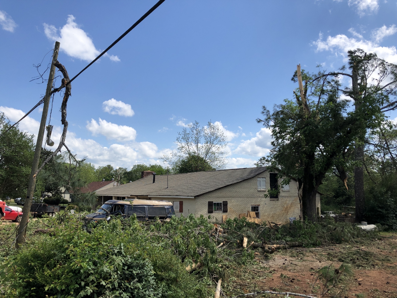
11) Upson and Lamar County Tornado:
A strong tornado formed near the city limits of Thomaston, increasing in intensity as it traveled northeast. Along it's path, Southern Crescent Technical College and Raintree Golf and Country Club off us US 19 took a direct hit. The tornado continued to strengthen downing trees, some on top of cars and houses. At one point the tornado was over 2/3rds of a mile wide and flipped an unoccupied mobile home. As the tornado traveled into northeastern Upson county and southern Lamar county it weakened some before lifting. Overall, 159 structures were affected, 38 homes sustained minor damage, 20 sustained major damage, and 7 were destroyed.
 |
| Damage Path - Upson/Lamar County |
|
| County |
Rating |
# of Injuries |
KML |
| Upson/Lamar |
EF-3 |
0 |
|
|
| Rating: |
EF-3 |
| Peak Wind: |
140 MPH |
| Path Length: |
16.7 miles |
| Path Width: |
1200 yards |
| Fatalities: |
0 |
| Injuries: |
0 |
| Start Date: |
Apr. 13, 2020 |
| Start Time: |
2:19 AM EDT |
| Start Location: |
3 miles S of Thomaston |
| Start Lat/Lon: |
32.8496 / -84.3335 |
| End Date: |
Apr. 13, 2020 |
| End Time: |
2:35 AM EDT |
| End Location: |
1 mile NW of Redbone |
| End Lat/Lon: |
32.9943 / -84.1056 |
|
|
|
|
| This house was damaged along Triune Mill Road. In addition several tree were down at this location. |
|

|
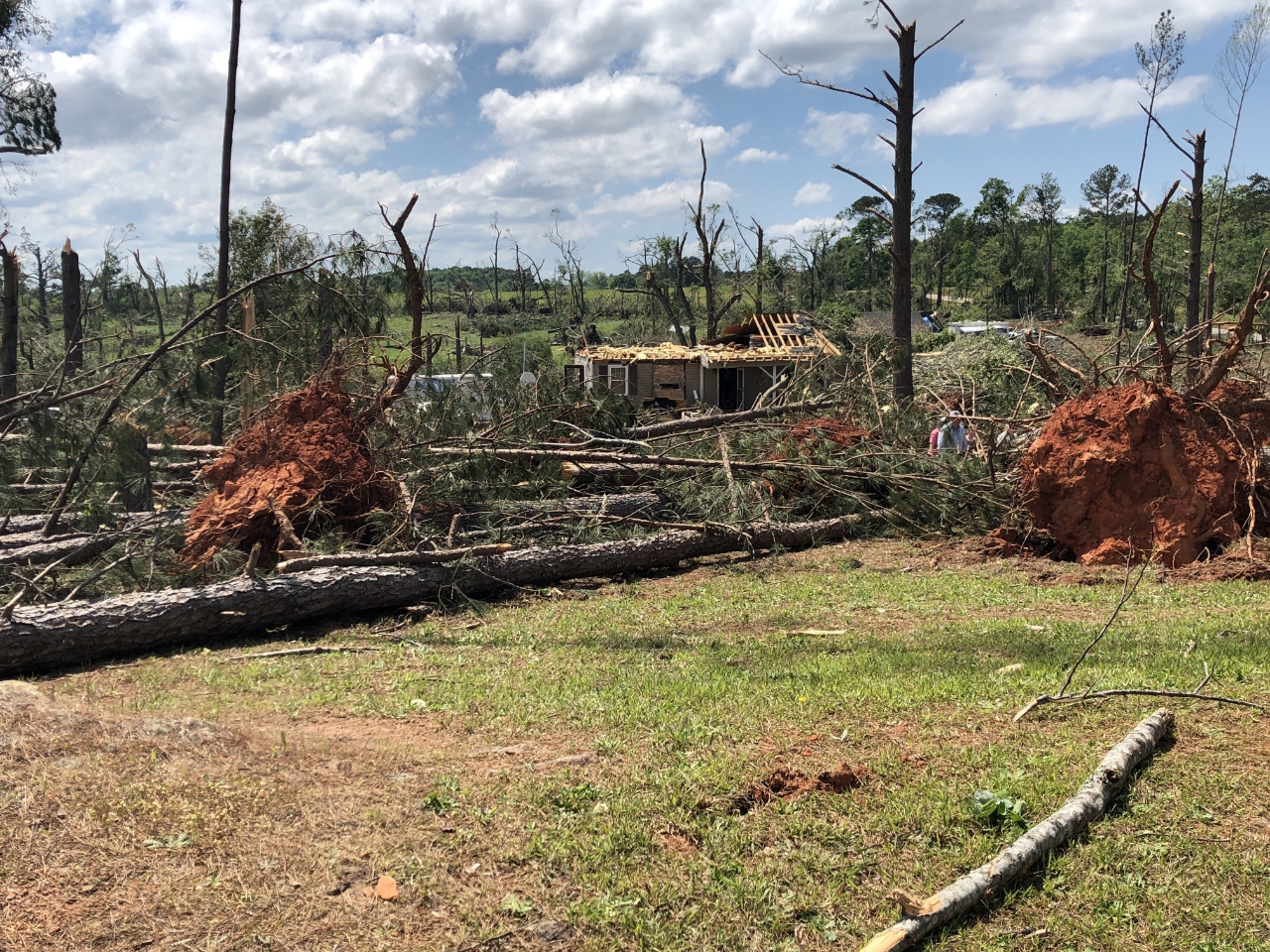 |
| This home was severely damaged along Yatesville Highway. |
Extensive damage occurred to this home and surrounding trees. |
- Back to Top -
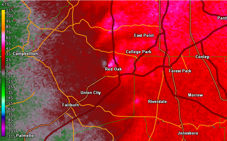
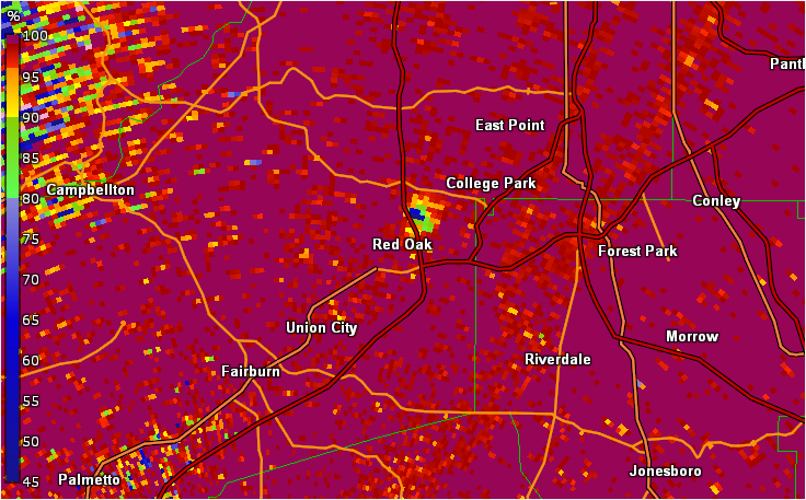
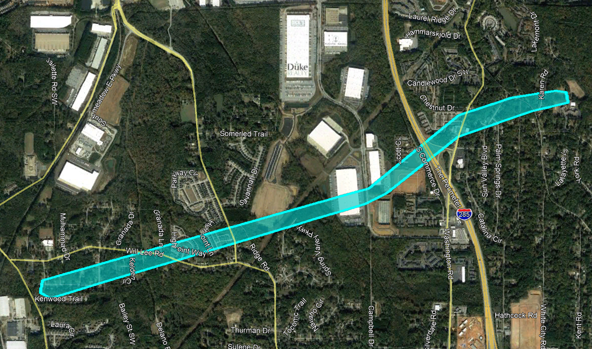
12) Fulton County Tornado:
A weak EF-0 tornado briefly touched down in southwestern Fulton County at around 2:36 AM along Welcome All Terrace SW. A few trees were uprooted or snapped behind some homes along this street. The tornado continued northeast, downing small limbs and lofting debris. NWS radar detected lofted debris at about 1000 feet as the tornado crossed Delano Road. Ground evidence suggested that this was mostly small limbs and leaves as there was no widespread damage along the ground but only more sporadic large limbs and occasional trees down. The storm continued northeast, crossing North Commerce Drive where several rees were snapped or uprooted in between two large warehouses. No other damage was noted in the area, though a debris signature continued to be present on radar. The storm crossed Interstate 285 and then Washington Road where a large tree was downed, causing minor damage to a house. Several rees were snapped behind a home along Janice Drive and along Karen Road before the tornado lifted.
 |
| Damage Path - Fulton County |
|
| County |
Rating |
# of Injuries |
KML |
| Fulton |
EF-0 |
0 |
|
|
| Rating: |
EF-0 |
| Peak Wind: |
75 MPH |
| Path Length: |
2.75 miles |
| Path Width: |
50 yards |
| Fatalities: |
0 |
| Injuries: |
0 |
| Start Date: |
Apr. 13, 2020 |
| Start Time: |
2:36 AM EDT |
| Start Location: |
4 miles NNE of Union City |
| Start Lat/Lon: |
33.6288 / -84.5263 |
| End Date: |
Apr. 13, 2020 |
| End Time: |
2:39 AM EDT |
| End Location: |
2 miles WSW of College Park |
| End Lat/Lon: |
33.6425 / -84.4824 |
|
|
|
|
 |
| This home sustained roof damage from a tree on Washington Road. |
Several trees also fell around this home along Yates Road. |
- Back to Top -
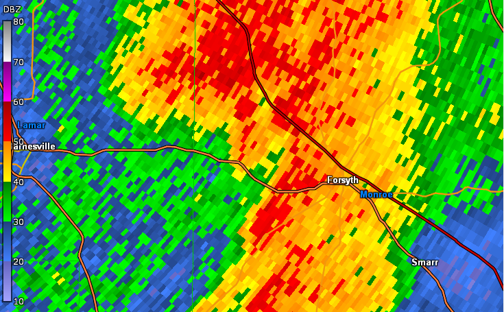
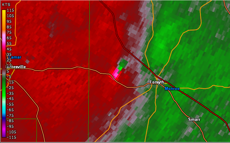
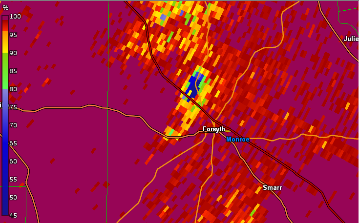
13) Monroe County Tornado:
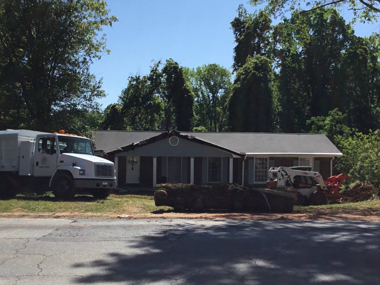
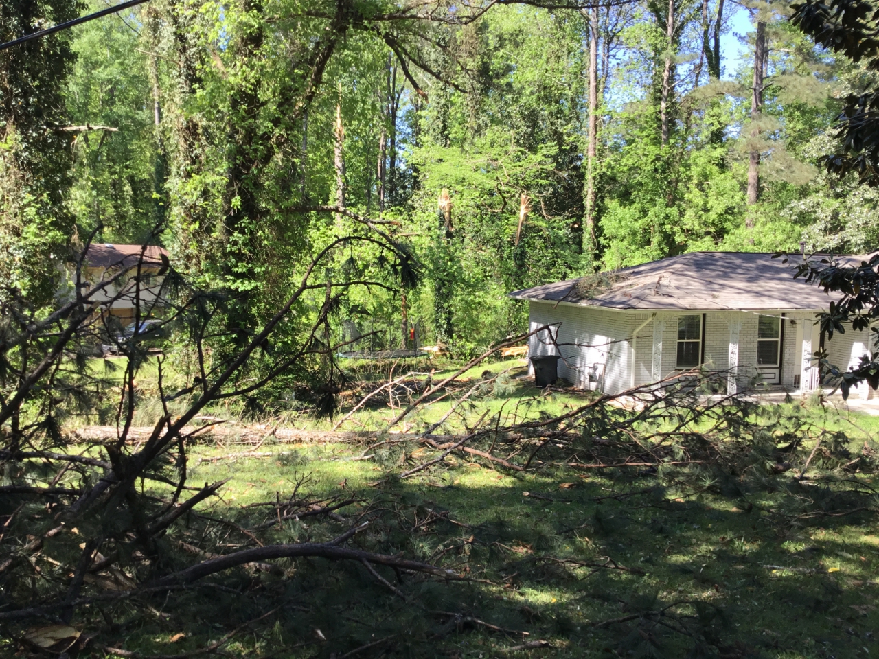
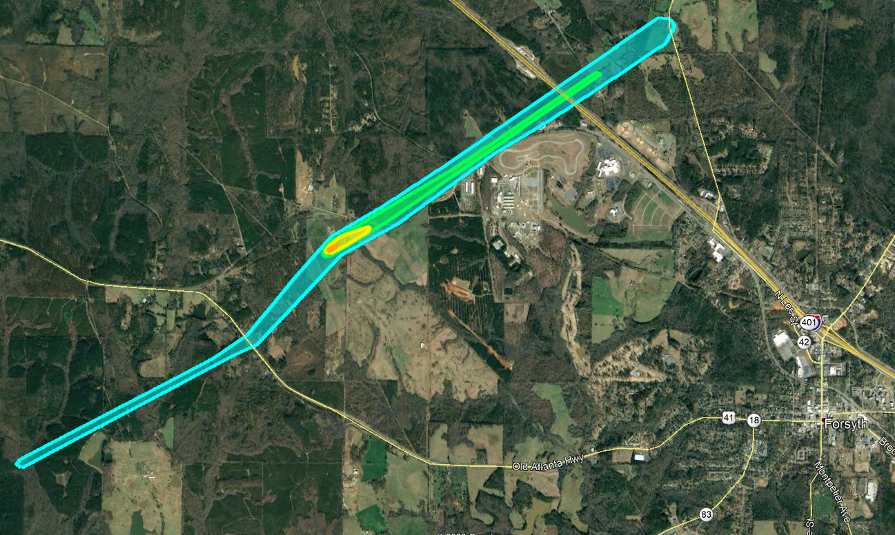
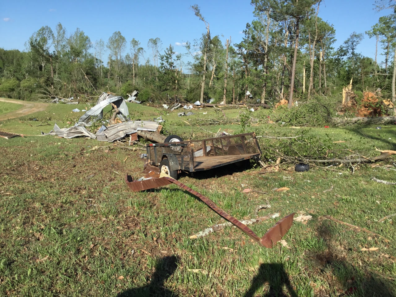
This tornado is a regeneration from the same storm that caused the Upson County EF-3 tornado to the southwest. This tornado first touched down along Potts Cemetery Road, downing a few trees. The tornado continued northeast, crossing Highway 41 and Ingram Road, snapping and uprooting a few trees. This portion of the track was rated EF-0. The tornado wound up quickly northeast of Highway 41 into an EF-3 as it approached Goodwyne/Collier Road. A large 100'x150' metal building and adjacent home were completely destroyed. The metal frame and 3'x3'x3' conrete footers for the building were all pulled from the ground with the building and twisted amongst the wreckage, leaving holes in the ground around the concrete slab. Several cars were flipped and thrown, including a Jeep which was thrown onto the small home which sat next to the metal building. The homeowner was inside his home in the bathroom sheltering and survived under the large pile of debris from both the house and the building. Rescue operations took 45 minutes to get to the homeowner under the debris. A small plane was destroyed, a mid-sized tractor was flipped over, and a boat was thrown from the tornado at this location. High end EF-1/EF-2 tree damage occurred in the area surrounding this location and to the northeast of the building. As the tornado continued northeast along Collier Road, numerous trees were snapped and uprooted, including a large tree onto a home near Collier and Smith Road. The tornado crossed Interstate 75 near mile marker 188, throwing numerous trees onto the highway and shutting it down for a period of time until cleared. By this point, the tornado intensity decreased to EF-0/EF-1 and continued norhteast, crossing English Road and downing trees. The tornado crossed Highway 42 and weakened and dissipated. NWS Radar imagery suggests debris was lofted to as high as 19,000 feet from this tornado.
 |
| Damage Path - Monroe County |
|
| County |
Rating |
# of Injuries |
KML |
| Monroe |
EF-3 |
1 |
|
|
| Rating: |
EF-3 |
| Peak Wind: |
140 MPH |
| Path Length: |
5.3 miles |
| Path Width: |
300 yards |
| Fatalities: |
0 |
| Injuries: |
1 |
| Start Date: |
Apr. 13, 2020 |
| Start Time: |
2:40 AM EDT |
| Start Location: |
2 miles SW of Collier |
| Start Lat/Lon: |
33.0298 / -84.033 |
| End Date: |
Apr. 13, 2020 |
| End Time: |
2:47 AM EDT |
| End Location: |
3 miles NNW of Forsyth |
| End Lat/Lon: |
33.0729 / -83.9576 |
|
|
|

|
| The tornado flipped this car along Collier Road. |
|

|
 |
| This large metal building was destroyed along Collier Road. |
Damage from the homes and metal building on Collier road was thrown into the fields behind the house. |
- Back to Top -
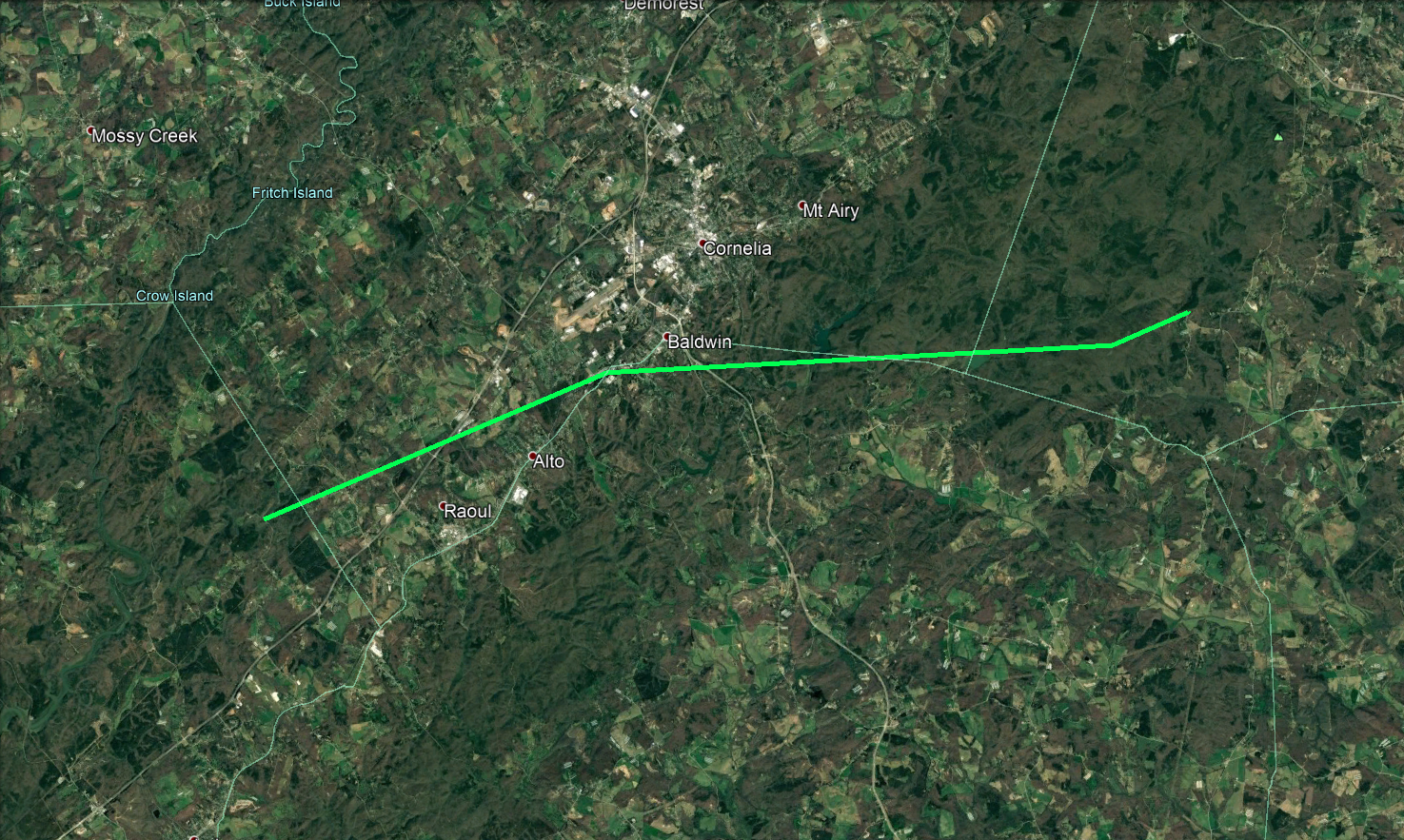
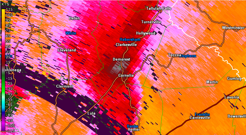
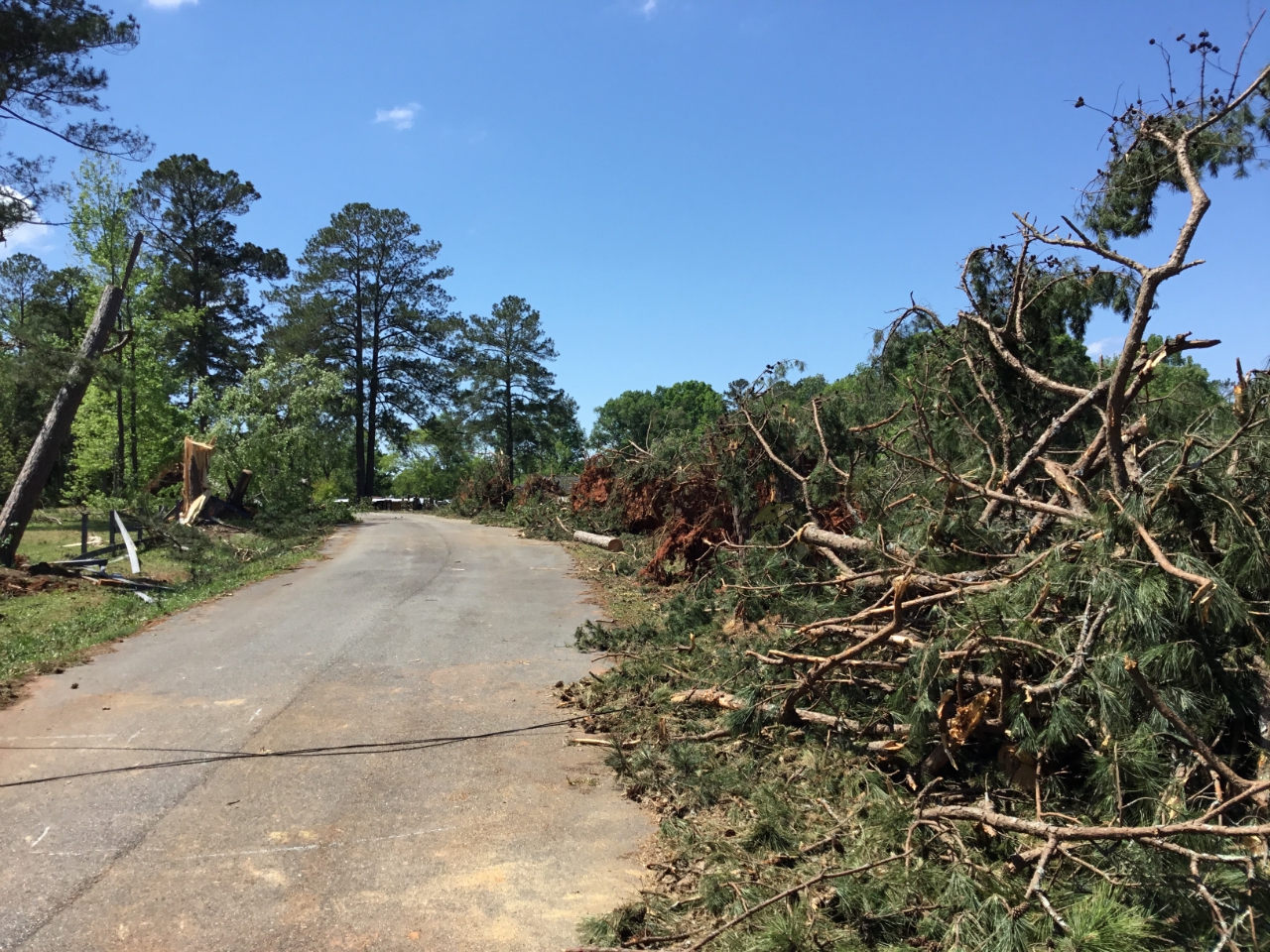
14) Hall/Habersham/Banks/Stephens County Tornado:
*Tornado Survey Conducted by NWS Greenville-Spartanburg.*
This tornado touched down in extreme northeast Hall County at around 2:50 AM EDT, but quickly crossed into Habersham County along Herring Mill Road. The tornado moved east-northeast, crossing U.S. 23 just west of Alto. The tornado began to move in more of an easterly direction as it moved across the south side of the city of Baldwin, taking it into Banks County at around @;56 AM near the intersection of Park Avenue and Old Orchard Road. The tornado continued east from Baldwin, although damage indicators became more sporadic as it passed through a remote portion of the Chattahoochee-Oconee National Forest. The tornado briefly crossed over the southeast corner of Habersham County at around 2:59 AM before moving into Stephens County, apaprently dissipating in the Old Cannon Rd/East Red Root Road area. Damage along the entire path was largely limited to snapped and uprooted trees, although one mobile home received minor to moderate roof damage on Hamby Mountain Park Lane in Baldwin (Banks County).
 |
| Damage Path - Hall/Habersham/Banks Counties |
|
| County |
Rating |
# of Injuries |
KML |
|
Hall//Habersham
/Banks/Stephens
|
EF-1 |
0 |
|
|
| Rating: |
EF-1 |
| Peak Wind: |
100 MPH |
| Path Length: |
14.38 miles |
| Path Width: |
200 yards |
| Fatalities: |
0 |
| Injuries: |
0 |
| Start Date: |
Apr. 13, 2020 |
| Start Time: |
2:50 AM EDT |
| Start Location: |
2 miles W of Raoul |
| Start Lat/Lon: |
34.4560 / -83.6449 |
| End Date: |
Apr. 13, 2020 |
| End Time: |
3:03 AM EDT |
| End Location: |
2 miles SSW Boydville |
| End Lat/Lon: |
33.0729 / -83.9576 |
|
|
|
|
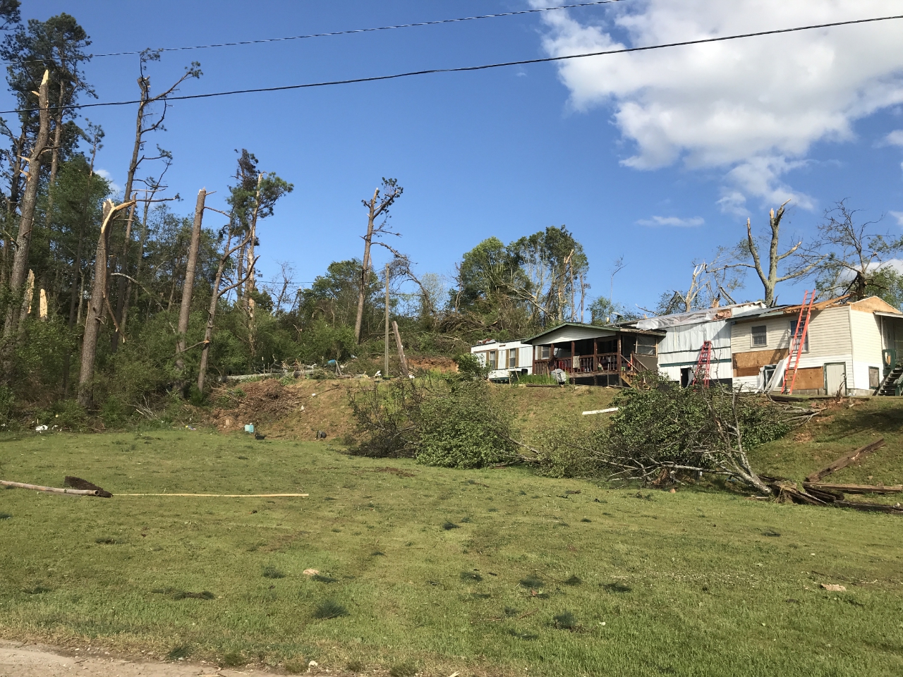 |
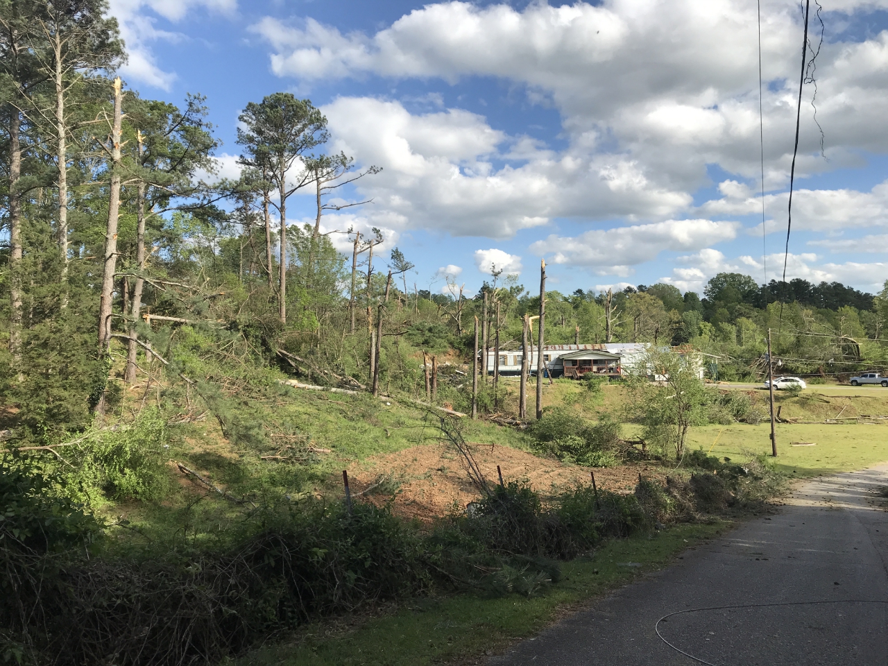
| Significant tree damage and damage to this mobile home occurred on Hamby Mountain Park Lane in Banks County. |
This mobile home on Hamby Mountain Park Lane in Banks County received the worst structural damage in this tornado. |
|
|
 |
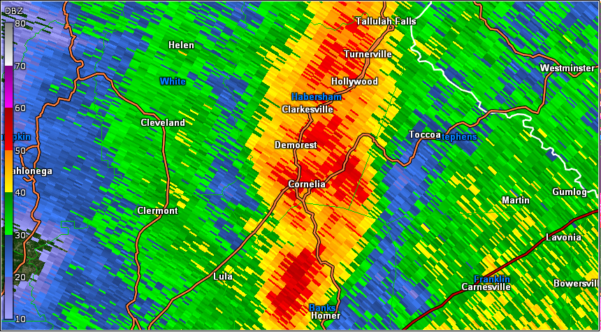
| Reflectivity (2:43 AM EDT). |
Velocity (2:43 AM EDT). |
|
- Back to Top -
15) Bibb County Tornado:
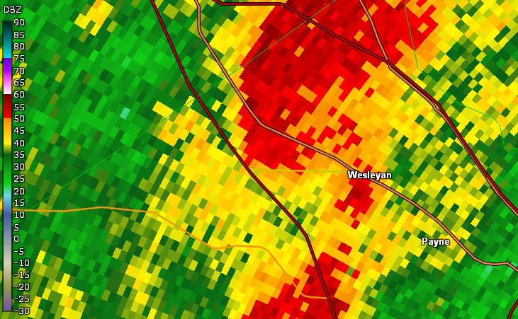
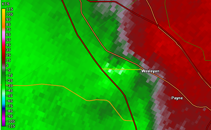
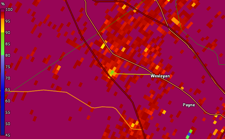
A tornado briefly touched down in Macon as a line of strong storms moved through the city. The tornado first touched down on Edgewater Drive, causing a tree to fall onto a house. The storm crossed I-475 and ripped shingles and roofing material off of 2 hotels next to the interstate and blew down a fence. The tornado then crossed Zebulon Road where the front door and windows of a Walgreens store were completely blown inward and a large hole was blown through the roof. Most of the interior shelving and ceiling was blown over and downed with significant damage to the store occurring. A Walmart store adjacent to the Walgreens had its sunroofs blown out with minor roof damage elsewhere. Numerous trees were uprooted in and around the Walmart parking lot. Further up Zebulon Road, a gas station canopy sustained damage, with much of the metal sheeting peeled and thrown. Significant shingle damage occurred to a small professional building next to this gas station, and a large tree was downed onto Zebulon Road next to the Chick-fil-A. The storm continued northeast and hit the subdivision along Huddersfield Road and Wakefield Way, downing numerous large trees. Several were downed onto homes, causing major damage. The tornado began to weaken as it continued northeast across Forysth Road, downing branches and tree limbs. The tornado ended near Wesleyan Drive and Tharpe Drive where a few trees were downed.
 |
| Damage Path - Bibb County |
|
| County |
Rating |
# of Injuries |
KML |
| Bibb |
EF-1 |
0 |
|
|
| Rating: |
EF-1 |
| Peak Wind: |
100 MPH |
| Path Length: |
3.7 miles |
| Path Width: |
300 yards |
| Fatalities: |
0 |
| Injuries: |
0 |
| Start Date: |
Apr. 13, 2020 |
| Start Time: |
3:00 AM EDT |
| Start Location: |
3 miles W of Wesleyan |
| Start Lat/Lon: |
32.8730 / -83.7718 |
| End Date: |
Apr. 13, 2020 |
| End Time: |
3:04 AM EDT |
| End Location: |
2 miles N of Wesleyan |
| End Lat/Lon: |
32.8997 / -83.7170 |
|
|
|

|

|
| The Walgreens on Zebulon Road suffered major damage when the entryway doors were blown into the store. |
A large tree sliced through this home on Huddersfield Road. |
- Back to Top -
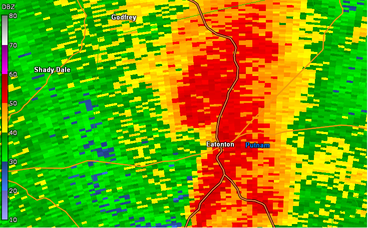
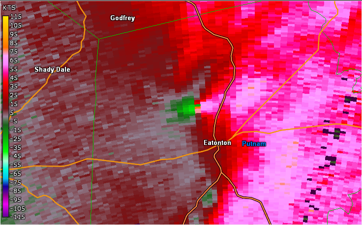
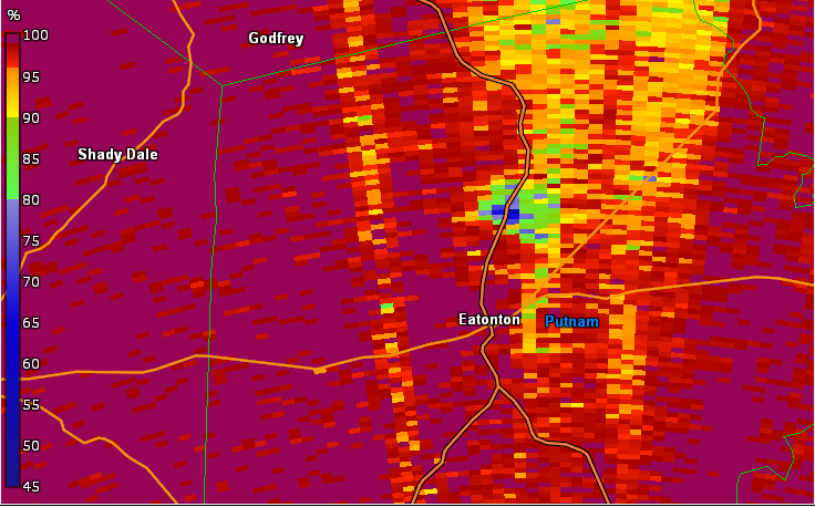
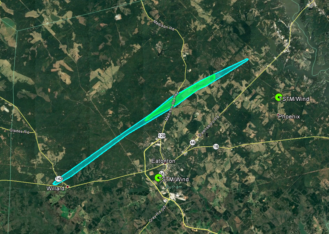
16) Putnam County Tornado:
A high-end EF-1 tornado touched down along Shady Dale Road in Putnam County, knocking down a few trees. The tornado continued norhteast through the Oconee National Forest, downing trees and crossing Godfrey Road, where numerous trees were snapped or uprooted. Most of the damage to this point was rated EF-0 to low end EF-1. As the tornado moved northeast, crossing Reids Road, it intensified to maximum intensity, snapping hundreds of trees ten feet off the ground. The storm continued northeast, crossing Highway 129 and snapping and uprooting trees. Three homes located along the highway sustained minor roof damage from the storm. The storm crossed Bethel Church Road, snapping trees, and across Lower Harmony Road where the top of a silo was torn off in addition to the roofing material from a nearby barn. The storm eventually crossed Denham Road, knocking over a few trees before lifting as it approached a neighborhood along Hunters Chase Court.
 |
| Damage Path - Putnam County |
|
| County |
Rating |
# of Injuries |
KML |
| Putnam |
EF-1 |
1 |
|
|
| Rating: |
EF-1 |
| Peak Wind: |
105 MPH |
| Path Length: |
13 miles |
| Path Width: |
300 yards |
| Fatalities: |
0 |
| Injuries: |
1 |
| Start Date: |
Apr. 13, 2020 |
| Start Time: |
3:18 AM EDT |
| Start Location: |
Willard, GA |
| Start Lat/Lon: |
33.3098 / -83.4961 |
| End Date: |
Apr. 13, 2020 |
| End Time: |
3:34 AM EDT |
| End Location: |
2 miles WSW of Phoenix, GA |
| End Lat/Lon: |
33.4111 / -83.3082 |
|
|
|
|
 |
| Multiple trees were downed along Highway 129. |
Multiple trees were downed along Reids Road. |
- Back to Top -
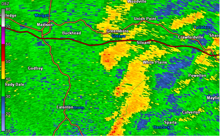
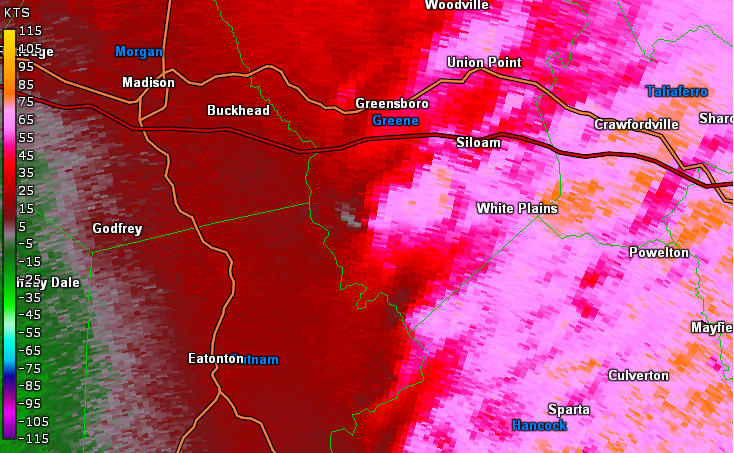
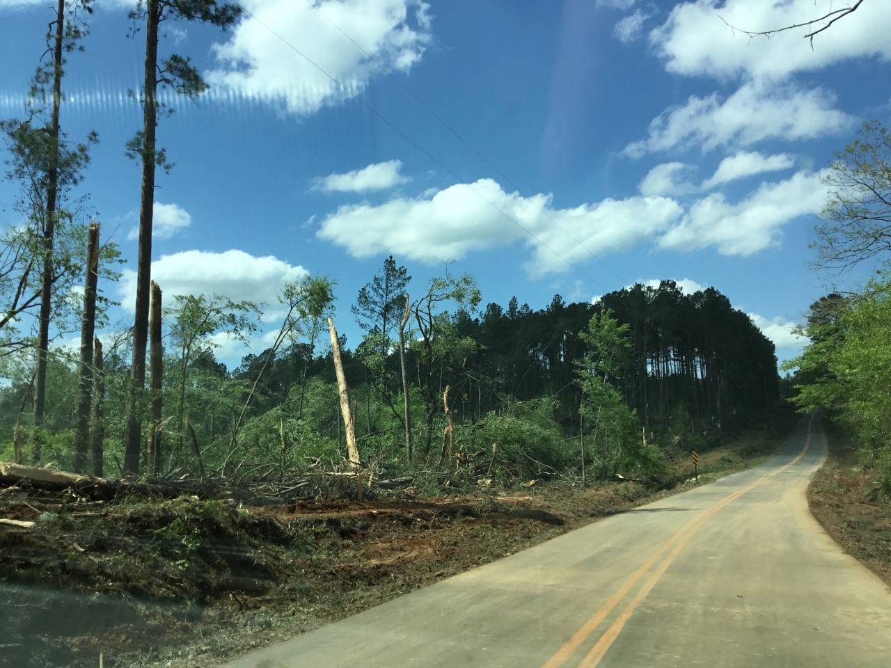
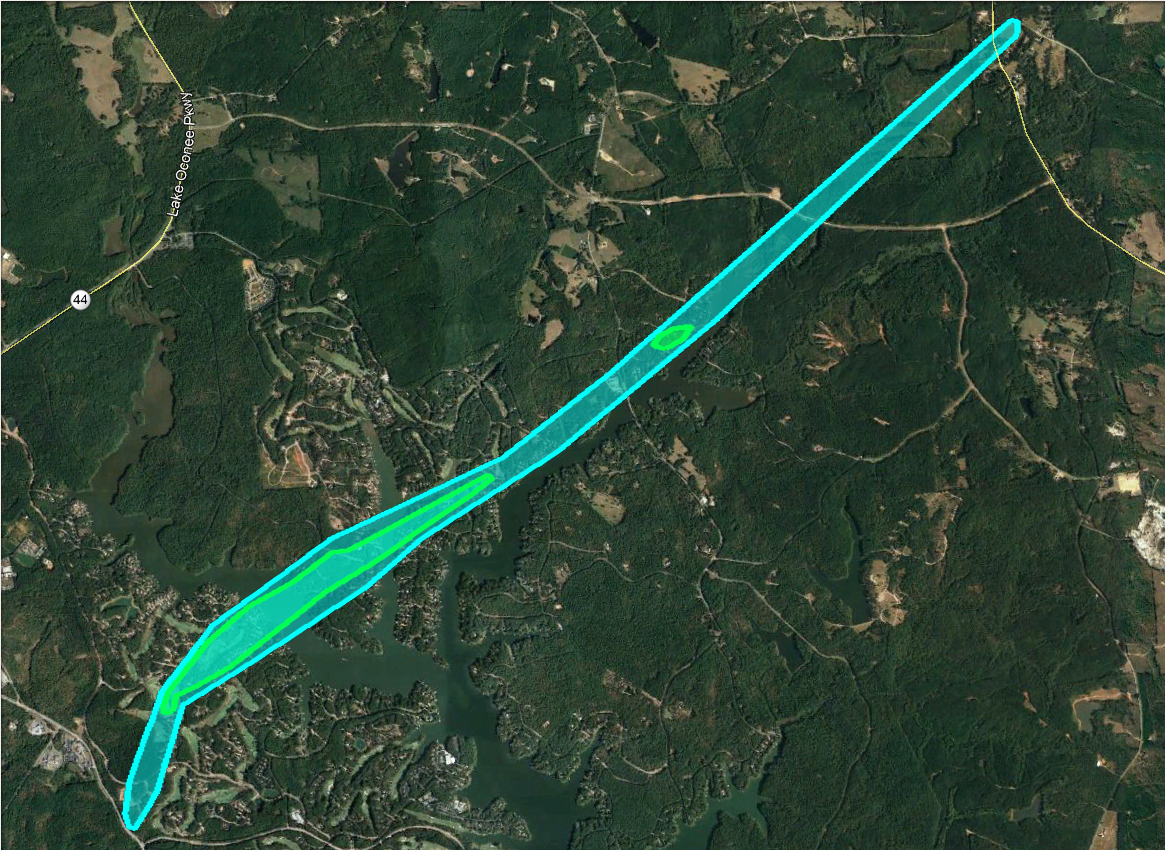
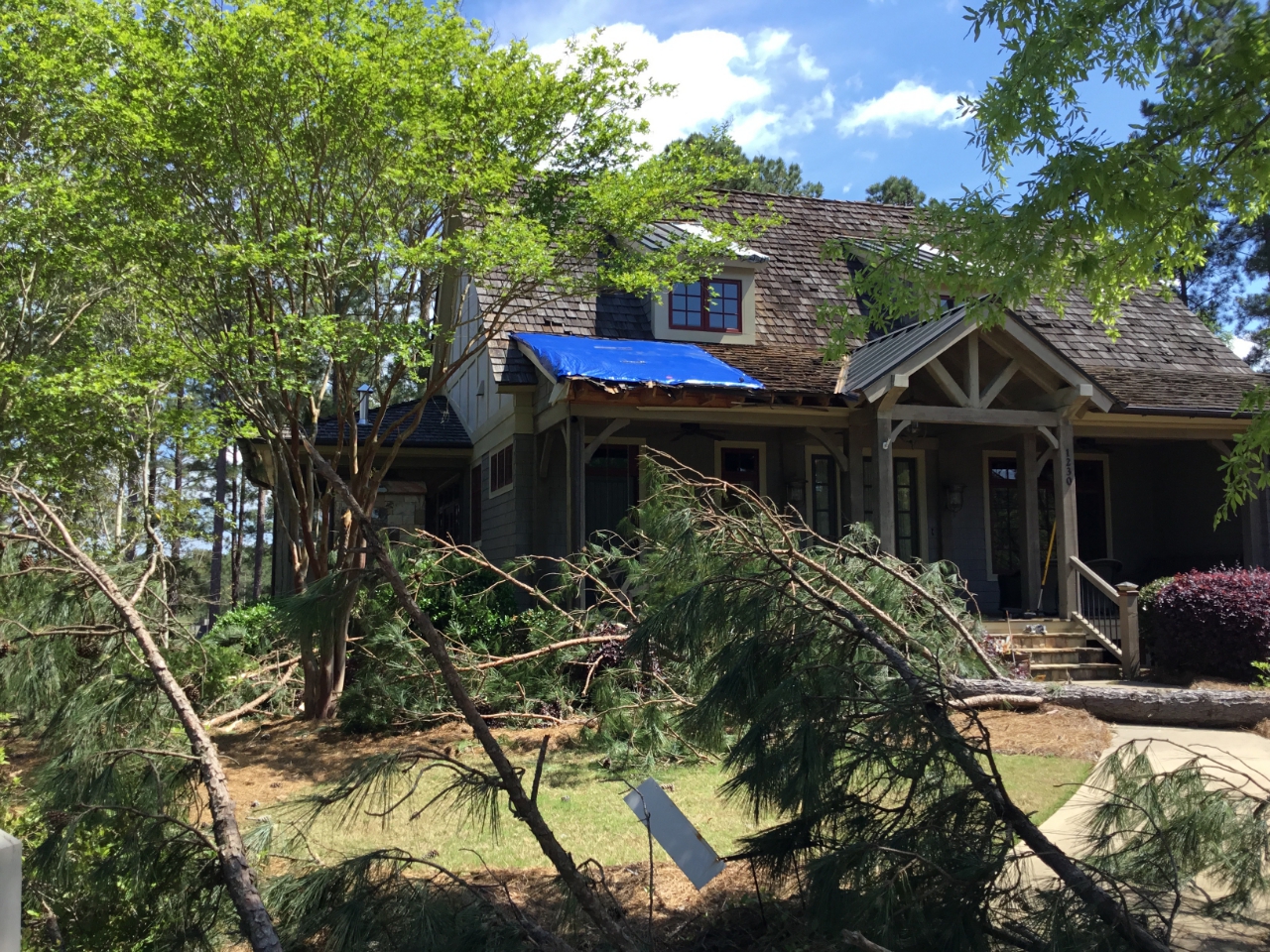
17) Greene County Tornado:
The same storm which generated a tornado in Putnam County regenerated a new EF-1 tornado once it crossed into Greene County at Lake Oconee. The tornado first touched down along Reynolds Parkway within the Creek Club Reynolds subdivision, snapping and uprooting a few trees. As the tornado continued northeast through the subdivision, it intensified to maximum intensity near the golf course at Rose Creek and Cottage Lane. Several well-built homes sustained minor roof damage from wind and debris. Hundreds of trees were snapped or uprooted in the area between Sandy Ford and Rose Creek. The tornado reached the point at the end of Rose Creek where several homes had trees fall onto them, causing more significant damage. A portion of dock at a home on Rose Creek was lifted out of the water and thrown onto the shore. Numerous boathouses also sustained damage. The storm crossed a portion of Lake Oconee and emerged into another subdivision along Cherokee Drive, Cloudland Court, and Eagle Bluff Drive, where numerous trees were snapped and uprooted. Several homes sustained damage from trees at this location as well. The storm crossed Bouldercrest Way and Sun Valley Court, across another portion of Lake Oconee, and up Club Drive, snapping and uprooting trees. The tornado weakened a bit as it moved up Armour Rod, with EF-0 type tree damage, and crossed Fleur du Lac Lane where a pocked of EF-1 tree damage was observed and a home was severely damaged from a falling tree. The storm continued to weakene as it moved northeast and dissipated as it crossed Veaszy and White Plains Road where a tree was knocked over. In total, an estimated 35 to 40 homes were impacted by trees in this tornado.
 |
| Damage Path - Greene County |
|
| County |
Rating |
# of Injuries |
KML |
| Greene |
EF-1 |
0 |
|
|
| Rating: |
EF-1 |
| Peak Wind: |
105 MPH |
| Path Length: |
6.6 miles |
| Path Width: |
350 yards |
| Fatalities: |
0 |
| Injuries: |
0 |
| Start Date: |
Apr. 13, 2020 |
| Start Time: |
3:38 AM EDT |
| Start Location: |
2 miles NNW Reynolds |
| Start Lat/Lon: |
33.4443 / -83.228 |
| End Date: |
Apr. 13, 2020 |
| End Time: |
3:47 AM EDT |
| End Location: |
Veazey, GA |
| End Lat/Lon: |
33.5048 / -83.1439 |
|
|
|
|
| This home sustained roof damage near Lake Oconee. |
|

|
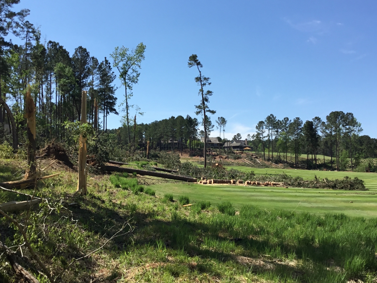 |
| Multiple trees were downed on the Creek Club Golf Course. |
Additional trees were downed on the Creek Club Golf Course. |
- Back to Top -
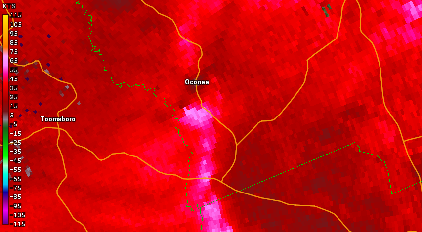
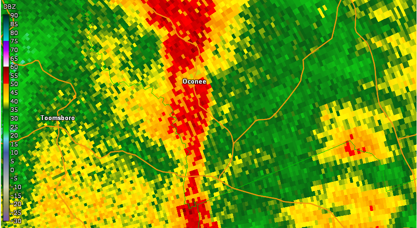
18) Washington County Tornado #1:
On the southern side of Washington county, a brief EF-0 tornado began just at the county border of Wilkinson and Washington counties. The tornado quickly moved northeast mainly producing tree damage before quickly lifting around Highway 272 south of the city of Oconee.
.PNG) |
| Damage Path - Washington County |
|
| County |
Rating |
# of Injuries |
KML |
| Washington |
EF-0 |
0 |
|
|
| Rating: |
EF-0 |
| Peak Wind: |
75 MPH |
| Path Length: |
1.7 miles |
| Path Width: |
50 yards |
| Fatalities: |
0 |
| Injuries: |
0 |
| Start Date: |
Apr. 13, 2020 |
| Start Time: |
4:01 AM EDT |
| Start Location: |
2 miles SW of Oconee |
| Start Lat/Lon: |
32.8329 / -82.9698 |
| End Date: |
Apr. 13, 2020 |
| End Time: |
4:02 AM EDT |
| End Location: |
1.5 miles SE of Oconee |
| End Lat/Lon: |
32.8359/ -82.9414 |
|
|
|
|
| Several trees were snapped in the area. |
- Back to Top -
19) Washington County Tornado #2:
This tornado was from a dual circulation separated by only 5 miles. This tornado produced EF-1 damage nearly exclusively with mainly tree damage of hardwood and softwood trees.
 |
| Damage Path - Washington County |
|
| County |
Rating |
# of Injuries |
KML |
| Washington |
EF-1 |
0 |
|
|
| Rating: |
EF-1 |
| Peak Wind: |
90 MPH |
| Path Length: |
3.1 miles |
| Path Width: |
100 yards |
| Fatalities: |
0 |
| Injuries: |
0 |
| Start Date: |
Apr. 13, 2020 |
| Start Time: |
4:05 AM EDT |
| Start Location: |
2.3 miles NNW of Warthen |
| Start Lat/Lon: |
33.1199 / -82.8228 |
| End Date: |
Apr. 13, 2020 |
| End Time: |
4:09 AM EDT |
| End Location: |
3.5 miles N of Warthen |
| End Lat/Lon: |
33.1557 / -82.7912 |
|
|
|
|
|
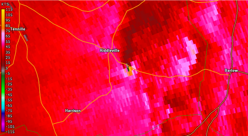
Multiple trees were snapped or uprooted along Highway 15.
|
|
.PNG)
|
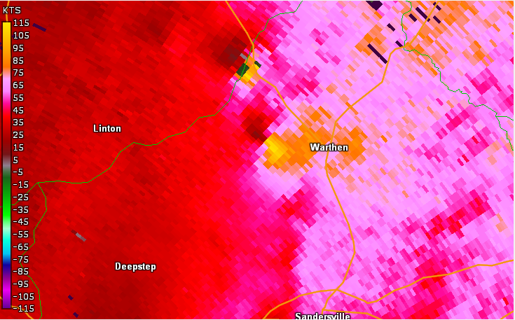 |
| Reflectivity (4:05 AM EDT). |
Velocity (4:05 AM EDT). |
- Back to Top -
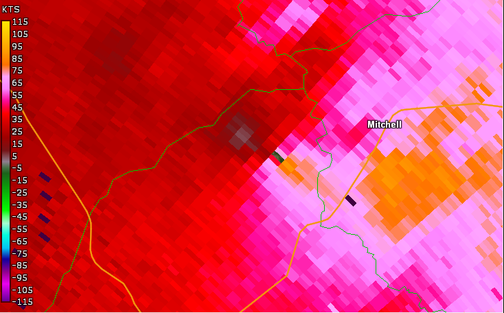
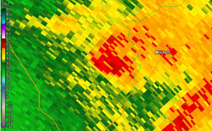
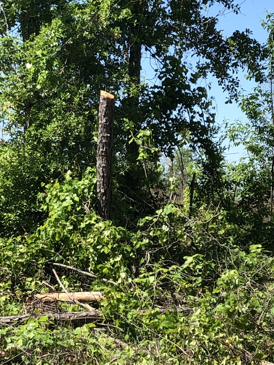
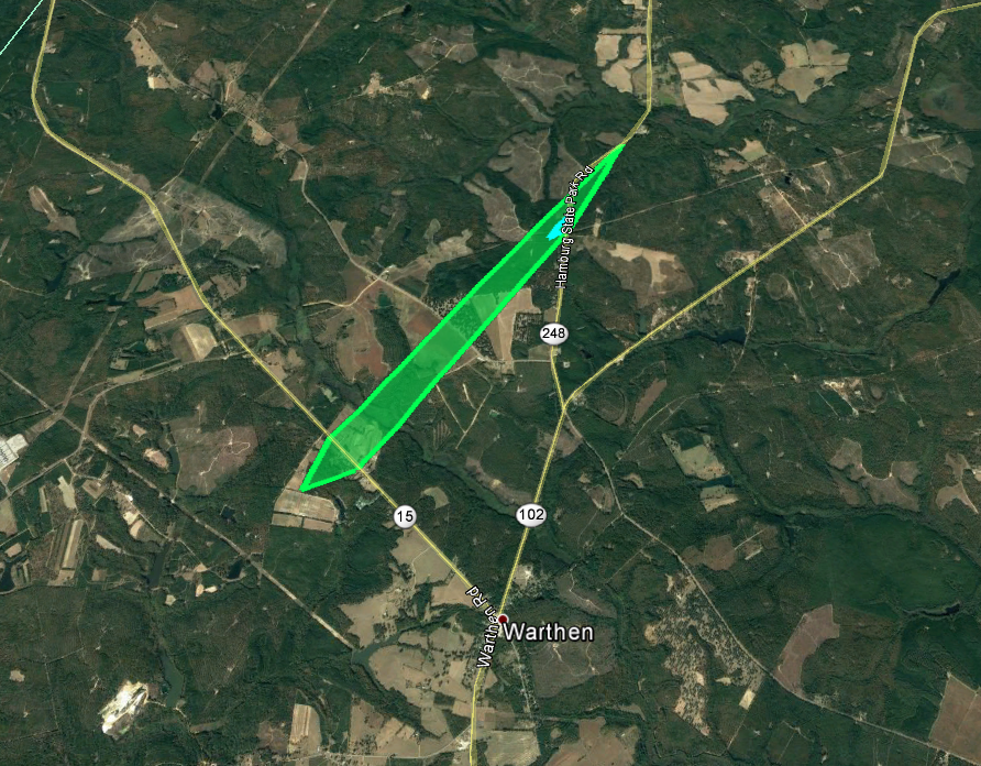
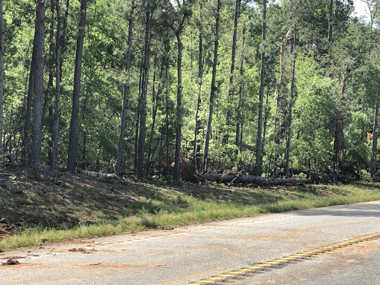
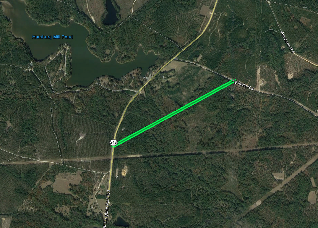
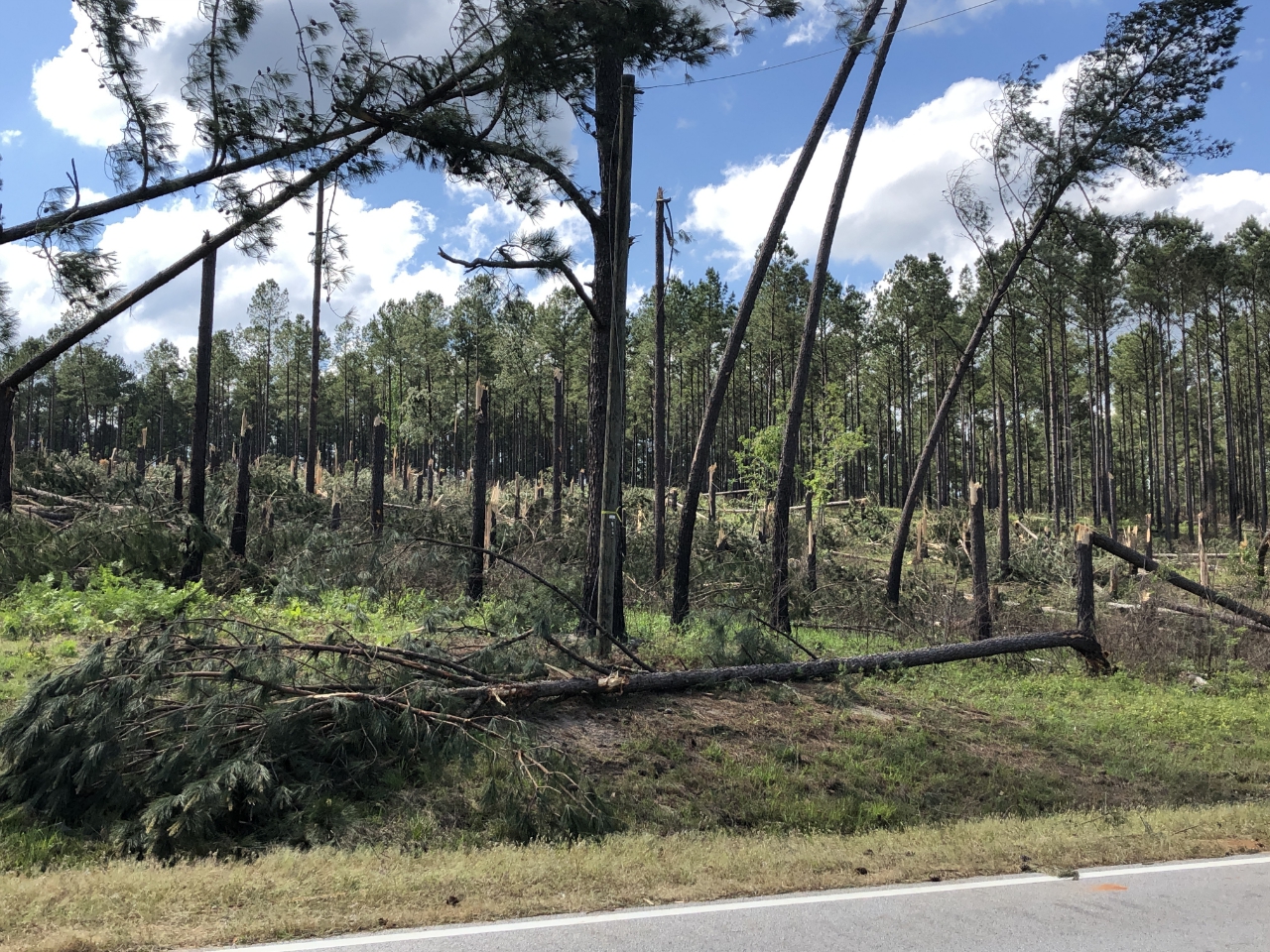
20) Washington County Tornado #3:
This tornado was also a part of a dual circulation only separated by 5 miles. This tornado snapped hundreds of mainly softwood trees even though it only traveled a mile. The most extensive damage was crossing Hamburg State Park Road.
 |
| Damage Path - Washington County |
|
| County |
Rating |
# of Injuries |
KML |
| Washington |
EF-1 |
0 |
|
|
| Rating: |
EF-1 |
| Peak Wind: |
100 MPH |
| Path Length: |
1.1 miles |
| Path Width: |
100 yards |
| Fatalities: |
0 |
| Injuries: |
0 |
| Start Date: |
Apr. 13, 2020 |
| Start Time: |
4:12 AM EDT |
| Start Location: |
5.2 miles SW of Mitchell |
| Start Lat/Lon: |
33.1992 / -82.7831 |
| End Date: |
Apr. 13, 2020 |
| End Time: |
4:14 AM EDT |
| End Location: |
4.3 miles SW of Mitchell |
| End Lat/Lon: |
33.2066 / -82.7681 |
|
|
|
|
 |
| Numerous trees were snapped and downed along Hamburg State Park Road. |
Multiple trees were snapped along Agricola Road. |
- Back to Top -
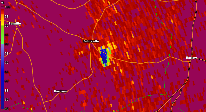
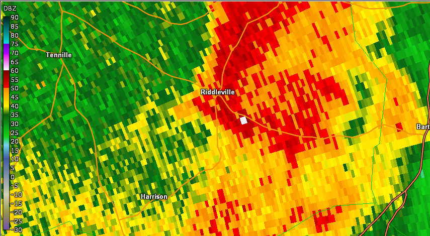
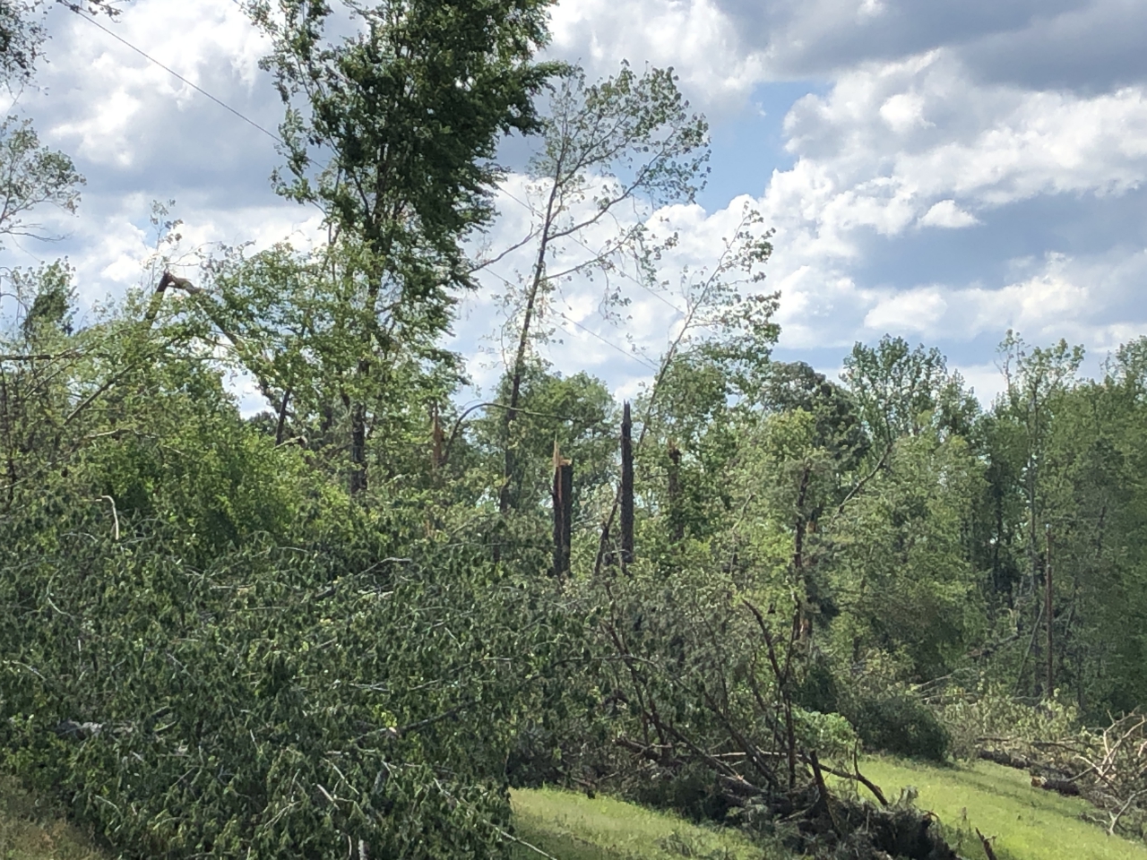
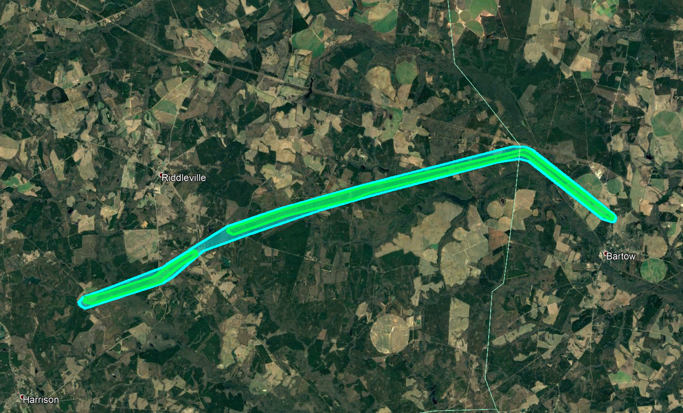
21) Washington and Jefferson County Tornado:
 |
| Damage Path - Washington and Jefferson County |
|
| County |
Rating |
# of Injuries |
KML |
| Washington/Jefferson |
EF-1 |
0 |
|
|
| Rating: |
EF-1 |
| Peak Wind: |
100 MPH |
| Path Length: |
14.3 miles |
| Path Width: |
220 yards |
| Fatalities: |
0 |
| Injuries: |
0 |
| Start Date: |
Apr. 13, 2020 |
| Start Time: |
4:18 AM EDT |
| Start Location: |
2.7 miles NE of Harrison |
| Start Lat/Lon: |
32.8613 / -82.6972 |
| End Date: |
Apr. 13, 2020 |
| End Time: |
4:31 AM EDT |
| End Location: |
1 mile S of Bartow |
| End Lat/Lon: |
32.8919 / -82.4719 |
|
|
|
.jpg)
|

|
| This home was severely damaged along Bartow Road. |
This home was destroyed on HJ Lane. |
- Back to Top -