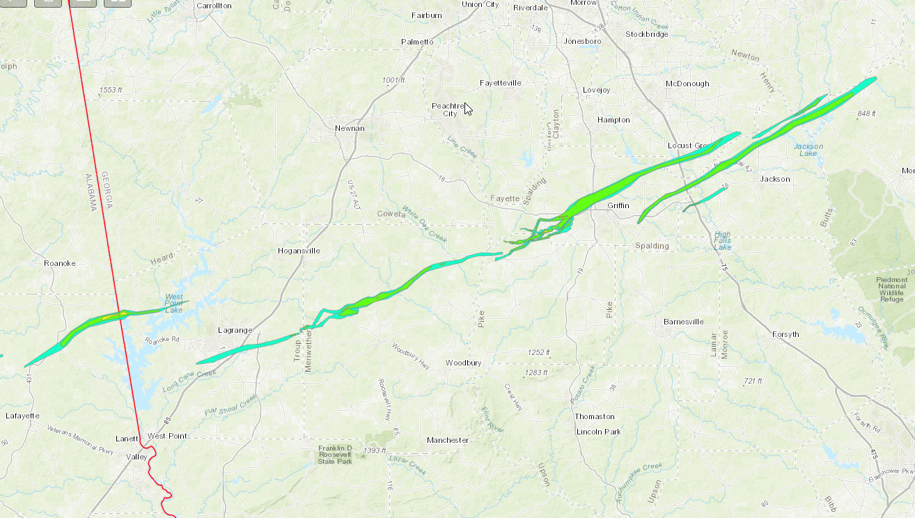
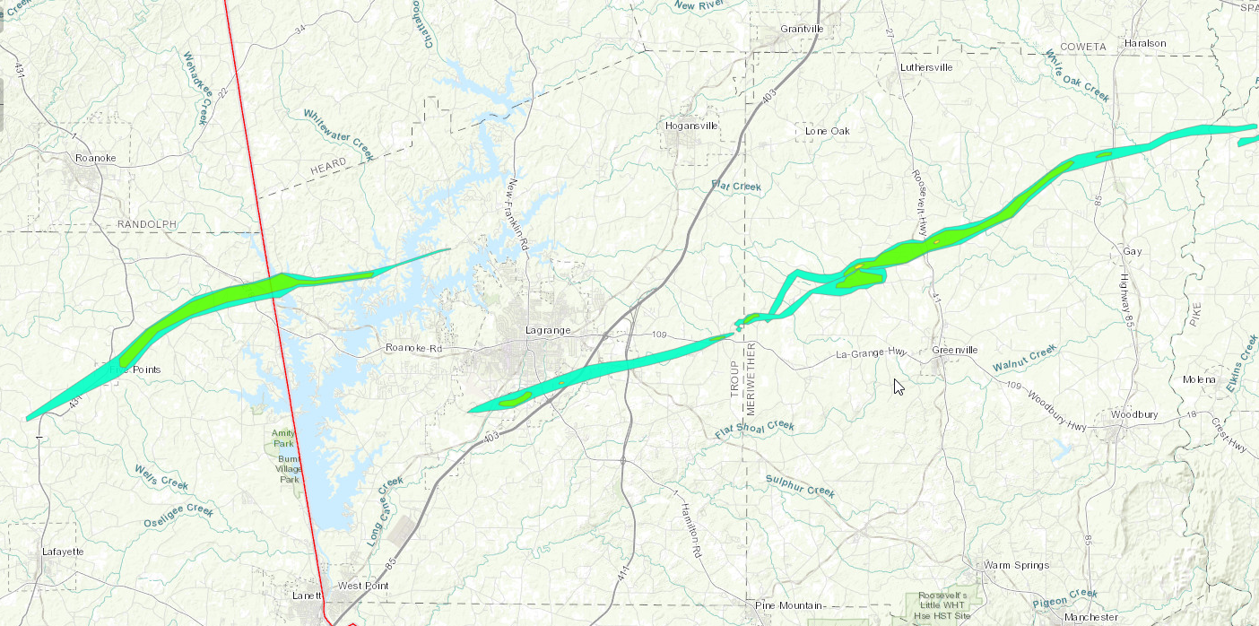
(1)..Standing Rock Tornado (NW Troup County)...
Rating: EF2
Estimated Peak Wind: 120 mph
Path Length /statute/: 20.9 miles
Path Width /maximum/: 1600 yards
Fatalities: 0
Injuries: 0
Start Date: 01/12/2023
Start Time: 03:08 PM EST
Start Location: 1 WSW White Plains / Chambers County / AL
Start Lat/Lon: 32.9871 / -85.4131
End Date: 01/12/2023
End Time: 03:24 PM EST
End Location: 1 SW Wares Crossroads / Troup County / GA
End Lat/Lon: 33.0972 / -85.0874
Survey Summary:
NWS meteorologists have surveyed damage in northeastern Chambers
County and determined it was consistent with an EF2 tornado. The
start point was a bit uncertain due to sporadic timber damage
around Five Points, but appears to be near County Road 114 west of
Highway 431 to the southwest of Five Points. Northeast of Five
Points, the tornado intensified, snapping and uprooting many trees
along County Road 267 and causing roof damage to a barn. The
swath of timber damage became almost a mile wide along County
Roads 281 and 282 and at least one residence there suffered roof
damage. The tornado continued to intensify as it crossed County
Road 268 where large swaths of pine trees were snapped. A
manufactured home was completely destroyed and blown downstream
near County Road 278; thankfully the family was not home at the
time. Most of the structural damage happened along County Road
284. A couple residences suffered significant shingle damage, one
had siding damage, and a manufactured home had its porch ripped
off, impacting its walls. Another manufactured building was blown
off its footings. Another significant swath of snapped pines was
observed on County Road 283, some snapped off only a couple feet
off the ground. The tornado then crossed into Georgia, continuing
to snap trees along West Point Lake.
Numerous trees were snapped along the end of North State Line Rd
as the tornado crossed the lake. The tornado began to weaken some
as it made its way into Deer Point Rd and Rock Mills Road where
tree damage and some damage to shingles and gutters occurred for a
few homes. The tornado continued east through mostly wooded
areas, doing damage to pines and crossing just north of a few
homes along Neely Rd. Weakening continued as it continued NE with
only minor tree damage occurring before the tornado dissipated
along Cameron Mill Rd.
<BACK TO TOP OF PAGE>
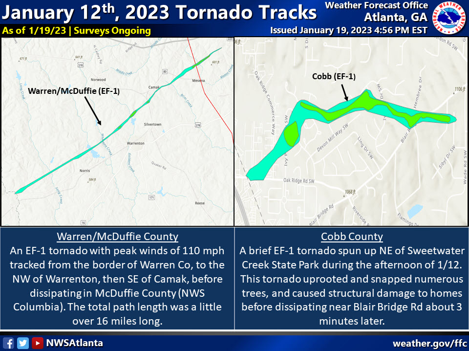
(2)..Cobb County Tornado...
Rating: EF1
Estimated Peak Wind: 110 mph
Path Length /statute/: 1.5 miles
Path Width /maximum/: 150 yards
Fatalities: 0
Injuries: 0
Start Date: 01/12/2023
Start Time: 03:30 PM EST
Start Location: 2 NNE Sweetwater Creek State Park / Douglas County / GA
Start Lat/Lon: 33.7830 / -84.6071
End Date: 01/12/2023
End Time: 03:33 PM EST
End Location: 2 WNW Six Flags Over Georgia / Cobb County / GA
End Lat/Lon: 33.7867 / -84.5823
Survey Summary:
As a line of strong to severe thunderstorms moved through the
west Atlanta metropolitan area and into southwest Cobb county, a
brief tornado spun up near the intersection of Oak Ridge Rd and
Oak Ridge Pkwy SW, which is about a half-mile to the north of I-
20. The tornado immediately caused damage to the 18 Wheeler Truck
Parts & Chrome building, causing a portion of an exterior wall to
collapse. A door was open on the back side of the building,
providing a failure point as tornado winds entered the building.
The tornado moved northeastward across Ivy Pointe Row SW and Ivy
Log Dr SW, where several large and tall trees were snapped and
caused damage to roofs and walls of homes. The tornado then
turned east-northeast, bringing down additional trees onto Ivy
Log Dr SW, Maple Log Pl SW, and Poplar Log Pl SW. Two homes on
Poplar Log Pl SW sustained major damage as large trees fell on
the home, removing portions of the roof and walls, which were
then tossed by the tornado winds. The tornado then turned east-
southeastward, uprooting several trees on Hembree Ln SW and Blair
Bridge Rd SW, once again falling on homes and causing structural
damage. The tornado continued onto William Rd, snapping and
uprooting about a dozen trees before finally lifting and
dissipating over Myra Ln SW. No other notable damage was observed
beyond this point. There were locations along the track over
which it appears the tornado lifted just enough to bring taller,
larger trees down onto homes, but leave objects on the ground
mostly undisturbed. Maximum winds based on damage is estimated to
be 110 mph which equates to an EF1 rating.
<BACK TO TOP OF PAGE>
(3)..Troup County (LaGrange) Tornado...
Rating: EF2
Estimated Peak Wind: 120 mph
Path Length /statute/: 12.3 miles
Path Width /maximum/: 1060 yards
Fatalities: 0
Injuries: 4
Start Date: 01/12/2023
Start Time: 03:34 PM EST
Start Location: 3 NE Cannonville / Troup County / GA
Start Lat/Lon: 32.9927 / -85.0735
End Date: 01/12/2023
End Time: 03:47 PM EST
End Location: 1 ENE Mountville / Troup County / GA
End Lat/Lon: 33.0428 / -84.8720
Survey Summary:
Re-cycling from a parent supercell tracking from Chambers County
(Alabama) into Troup County (Georgia), this tornado touched down
just south of Callaway Airport, snapping several trees along
Pegasus Pkwy. Damage quickly picked up just to the northeast
approaching Whitesville Road (just north of I-85) where several
one-story metal buildings had significant roof damage, along with
their garage doors and windows blown in. Numerous trees in this
area were either snapped or uprooted. Several power poles along
Orchard Hill Road were broken off near the top. Maximum winds in
this area were determined to be in the 90-100 mph range (EF-1).As
the tornado continued northeast, a large warehouse building at
the Vaughan Xpress transportation facility sustained significant
damage. About 1/4 of the large warehouse was completely destroyed
with several metal bolt anchors stretched or ripped up out of the
concrete pad. Winds were estimated between 110-120 mph at this
time and as it crossed I-85, a large number of trees were snapped
(some near the base) or uprooted. Widespread significant damage
by this strong tornado continued across the Baldwin Park
community. In this location, more than 30 homes had significant
damage; one and two-story homes lost major parts of the roof and
upper level floors along with at least partial-collapse of
exterior walls. Debris was thrown for hundreds of yards. Winds in
this area likely maxed out around 120 mph, making this an EF-
2 tornado. The tornado continued east-northeast, cutting down
trees across Upper Big Springs Road, I-185, and Stewart Road
(east of I-185). There`s a fairly rural/wooded area between
Stewart Road and the next road (Parmer road) about 2 miles apart
but damage picked back up along Hwy 109/Greenville Road (mostly
trees snapped/uprooted). The tornado then ripped through the town
of Mountville, snapping and uprooting multiple medium to large
trees along Trippe and College streets. A couple more trees were
uprooted along Wood Road, but little to no damage was seen beyond
this area. Seeing this and what was on radar, this fairly long-
track tornado finally lifted just before the Meriwether County
line.
<BACK TO TOP OF PAGE>
(4)..Meriwether/Northwest Pike Tornado...
Rating: EF2
Estimated Peak Wind: 120 mph
Path Length /statute/: 24.45 miles
Path Width /maximum/: 1500 yards
Fatalities: 0
Injuries: 0
Start Date: 01/12/2023
Start Time: 03:45 PM EST
Start Location: 2 ENE Mountville / Meriwether County / GA
Start Lat/Lon: 33.0517 / -84.8527
End Date: 01/12/2023
End Time: 04:17 PM EST
End Location: 1 NW Hollonville / Pike County / GA
End Lat/Lon: 33.1762 / -84.4712
Survey Summary:
As the Troup County tornado lifted southeast of LaGrange just west
of the Troup-Meriwether County line, another long-track and
powerful tornado formed just east of the county line near Keith Rd
0.9 miles north of GA109. The tornado initially traveled north
then turned to a east-northeast direction crossing Wilbur Keith Rd
and Piney Woods Rd downing hundreds of trees. The tornado
broadened and intensified as it approached GA100 with a diameter
of 0.9 miles and winds over 100 mph uprooting and snapping over
1000 trees. A home on Forrest Rd had its entire roof blown off
where max winds were estimated at 120 mph and first reached EF- 2
intensity. The tornado continued at 100 to 120 mph intensity as it
continued east-northeast into neighborhoods south of Allie Rd
along Mount Pilgram Rd where several homes were damaged or
destroyed by trees falling on them. One double-wide manufactured
home on Ground Hog Dr had its roof blown off and was shifted 20
yards off its foundation, breaking the home in half. The tornado
continued east-northeast along Allie Rd crossing US27. Just east
of US27 a very large stand of trees were snapped and a large
recently-constructed two-story barn was destroyed. Just east of
this location, two single-wide mobile home completely destroyed.
The residents of one of the homes was at the hospital when the
tornado struck and returned home early next morning to find it in
shambles. Here, maximum winds were also rated at EF- 2 intensity
(120 mph). The tornado began to weaken east of this point and it
tracked a bit more northeast in direction, crossing Rocky Mountain
Rd and Malcom Rd before it traveled along Callaway Rd downing
several hundred more trees as it moved near the Alps community.
While the tornado remained weak east of this area, the overall
storm remained extremely strong and the tornado did not dissipate,
continuing east paralleling HWY 362 causing sporadic tree damage
before crossing the Flint River into NW Pike County crossing River
RD and lifting around the Kings Bridge Road. Here winds were only
75-80 mph downing several trees as far as could be seen from
public roadways. More recent analysis of radar data and areal
satellite imagery confirmed that this particular circulation
continued east into Pike County while 2 other tornadoes were
spinning up to the North and Northeast of this weakening
circulation.
<BACK TO TOP OF PAGE>

(5)..Pike/Spalding/Henry County Tornado...

Rating:                 EF3
Estimated Peak Wind:    155 mph
Path Length /statute/:  32.80 miles
Path Width /maximum/:   2200 yards
Fatalities:             0
Injuries:               18

Start Date:             01/12/2023
Start Time:             04:10 PM EST
Start Location:         1 W Hollonville / Pike County / GA
Start Lat/Lon:          33.1654 / -84.4785

End Date:               01/12/2023
End Time:               04:45 PM EST
End Location:           4 SW Fincherville / Henry County / GA
End Lat/Lon:            33.3734 / -84.0014

Survey Summary:
New high resolution areal imagery in concert with a reanalysis of
radar data, areal surveys and ground surveys it has been
determined that there were multiple tornadoes on the ground
simultaneously in southwest Spalding and Northwestern Pike
Counties as well as crossing tornado paths. The tornadoes were
part of a larger mesocyclone which can be traced west all the way
back to the Selma Alabama tornado. Our analysis determined that
this tornado would become the dominant circulation which impacted
Griffin and much of Spalding County and Southern Henry County.
The tornado first touched down in Northwest Pike County along HWY
362 west of Irish Hill Drive where a few trees were snapped and
uprooted and quickly increased in intensity to EF1 as it crossed
Kings Bridge Road, Huff Creek Rd and Scott Road where numerous
trees were snapped and uprooted. As the storm crossed Blanton
Mill Road more severe damage was noted both on the ground and
areal survey and it was determined that EF2 damage was present in
the area around Nunnally Rd and Bethany Road where widespread
snapping of trees occurred and a few structures were severely
damaged. However, the updated analysis shows that this area also
experienced crossing tornado paths both from this tornado and
another which struck the area approximately 2 minutes later.  The
combination of the 2 paths likely resulted in more intense damage
indicators.  As the storm continued north into southern Spalding
County, the circulation briefly weakened causing only sporadic
low end EF0 damage northward along Scott Barch Road. It should
also be noted that this circulation would pass into southern
Spalding County along Scott Barch Road just 2 minutes ahead of
another EF1 tornado to cross its path coming in from the west.
The tornado continued north crossing Scott Barch Road and
uprooting trees in an area south of Blanton Mill Road. Per both
radar data and damage on the ground the tornado would pivot
within the larger mesocyclone in an area north of Blanton Mill
and begin its track east crossing Rover Zetella Road destroying a
barn. It was near this point the tornado and the wind damage
would significantly increase as the tornado was intensifying
rapidly. The tornado would quickly reach peak intensity of 150-
155 mph and several homes were completely destroyed along Kendall
Drive and West Road. 2 homes in particular were noted to be
completely destroyed down to the foundation however further
inspection of the homes revealed that the walls were not anchored
fully anchored into the concrete thus a higher rating could not
be determined from those homes. The resident of one of those
homes rode out the storm in his bathtub, however the bathtub and
all plumbing fixtures were torn away from the slab and tossed
into the nearby woods. The survivor of the home was miraculously
uninjured and got out to help neighbors. Further west along
Kendall Drive several homes were also completely destroyed with
several others suffering major damage thus the EF3 rating. The
damage along West Road in particular garnered a slight upgrade in
the wind speed to high end EF3 damage per a reanalysis.   Major
to severe damage was also noted along Maloy Road, Hwy 16, areas
around Griffin High School, The club at Shoal Creek and North
Pine Hill Road. As the tornado approached Hwy 19, per UGA
faculty, the UGA facility at Dempsey Farm recorded a wind speed
of 81.1 mph before the anemometer/wind combo instrument blew off
the tower. The tornado continued ENE through the community of
Experiment to the NW of the town of Griffin crossing HWY 92 where
numerous business and homes suffered damage either from wind or
fallen trees consistent with EF0 through EF1 damage. A weather
instrument on the south end of the tornado swath at the UGA
Griffin Campus recorded a 73.9 mph wind gust as the storm passed
by. Damage in the area was consistent with EF0 type wind damage.
The tornado struck a Hobby Lobby building in an around Experiment
St and Hwy 92 which suffered severe damage to the roof, and
exterior walls on the northeast side. Damage to the building was
consistent with EF2 winds of approximately 130 mph. The tornado
continued Northeast through the northside of Griffin with mostly
EF0-EF1 type wind damage. Pockets of more severe damage were
noted along Northside Drive and McIntosh Road consistent with
high end EF1 damage. The tornado continued northeast crossing
Smoak Road and N. McDonough road where it was noted both on the
ground and from the air that the circulation weakened and the
damage become more sporadic in nature particularly the area from
Amelia rd eastward to I75 in southern Henry County. Once the
circulation crossed I75 intensity of the tornado increased to
a mid to high end EF1 with damage in the city
of Locust Grove. The tornado crossed LG Griffin Road where it
impacted numerous homes in a subdivision and snapped or uprooted
trees. The storm crossed Stanley K Tanger Road and through another
neighborhood affecting several homes including some high end EF1
damage. As the storm crossed Hwy 23 numerous trees were snapped or
uprooted and a new TDS appeared on radar. The tornado continued
NE across Jackson St, Grove Park Drive, Skyland Dr, S. Unity Grove
Road and S Ola grove road snapping and uprooting trees as well as
causing EF0 or in some cases EF1 damage to homes. The storm continued
ENE snapping and uprooting trees through Peaksville Road
where it shortly there after become less defined and eventually
merged with the circulation/tornado ongoing to the south in the
Jenkinsburg area. According to Spalding County officials,
approximately 1465 homes were affected in the city of Griffin and
754 were affected in the county with at least 250+ suffering major
damage or destroyed with assessments still ongoing. Additional
numbers from Pike and Henry county will be added to the total when
assessments are completed. The exact width of the tornado even with
the high resolution imagery is difficult to determine and a best
estimate will be used as a  result of the close proximity of other
tornado paths. Additionally,  EF0 and EF1 damage resulting from
both strong inflow into the large mesocylone and strong outflow on
the southern side of the circulation also make it a challenge to
separate tornado wind damage from very strong straight line wind damge.


<BACK TO TOP OF PAGE>

(6)..Northwest Pike / Southwest Spalding Tornado #2...

Rating:                 EF2
Estimated Peak Wind:    130 mph
Path Length /statute/:  9.26 miles
Path Width /maximum/:   1000 yards
Fatalities:             0
Injuries:               0

Start Date:             01/12/2023
Start Time:             04:13 PM EST
Start Location:         2 NW Hollonville / Spalding County / GA
Start Lat/Lon:          33.1959 / -84.4845

End Date:               01/12/2023
End Time:               04:22 PM EST
End Location:           2 NNW Rover / Spalding County / GA
End Lat/Lon:            33.2345 / -84.342

Survey Summary:
New high resolution areal imagery in concert with a reanalysis of
radar data, areal surveys and ground surveys it has been
determined that there were multiple tornadoes on the ground
simultaneously in southwest Spalding and Northwestern Pike
Counties as well as crossing tornado paths. The tornadoes were
part of a larger mesocyclone which can be traced west all the way
back to the Selma Alabama tornado. This particular tornado was
spinning up in extreme SW Spalding County near Holonville Road and
the Flint River as the EF2 tornado crossing Meriweather County
into NW Pike was weaking and winding down. The particular tornado
first showed a debris signature on radar in a marshy area near the
flint River east of Holonville Road. Areal satellite imagery and
newly acquired information from a homeowner along Huff Creek Road
confirm the track continued east just north of Huff Creek Road
snapping and uprooting hundreds of trees. The tornado Crossed
Hancock Road as a high end EF 1 before reaching Blanton Mill Road
where several outbuildings were destroyed, a home was damaged and
hundreds of trees were uprooted or snapped. As the tornado
continued east toward Nunnally Road it was noted that the tornado
which would become the Griffin Tornado had crossed approximately 2
minutes prior and as this tornado approached that area. Damage in
the Nunnally Road area is consistent with multiple circulations
crossing this region. Also as this EF1 tornado reached the
Nunnally/Bethany Road area, a strong surge in wind can be seen on
radar rotating ENE around the larger mesocyclone and catching this
tornado in this region. The particular tornado would be not only
becoming part of that wind surge but also merge with an EF1
tornado sinking ESE out of Spalding County approximately at the
Spalding/Pike county line in and around the Yarborough Mill Road
region. This tornado would become the dominate circulation per
radar analysis thus this track is continued ENE. As the EF1
tornado merges from the WNW, this tornado increases to max
intensity of EF2 in and around the Yarborough Mill Road and
Crystal Creek Drive area where several structures were severely
damaged or destroyed in addition to hundreds of trees snapped and
uprooted. Per damage analysis from imagery, this merging which
occurred likely resulted in the increased intensification of the
tornado to EF2 in this region. The tornado continued eastward
toward a large rock quarry along Rover Zetella Road. The tornado
snapped trees up to the Rock Quarry however, it appears that due
to the size of the quarry, the tornado redeveloped on the N side
of the quarry along Rover Zetella Road and continued east before
resuming a northward path. Numerous trees were snapped or uprooted
wet of Candler Road north across North Rover Road,Agape Avenue
and Bethel Lane. Numerous homes sustained everything from minor to
moderate damage in this area consistent with EF0 to EF1 winds.
This particular tornado continued north toward the stronger EF3
tornado occurring simultaneously ultimately absorbing this tornado
into the circulation in the area around Maloy road. Due to the
scope of the damage and the width, the exact location and the
damage attribution (which tornado caused which damage) becomes
difficult to discern even with the imagery. As a result, the exact
width is an estimate due to the challenges of determining where
one tornado damage swath ended and where another one started. The
one thing that can be certain is that the vortices/tornadoes did
merge near or just after the EF3 damage occurred.

<BACK TO TOP OF PAGE>
(7)..Southwest Spalding County Tornado...

Rating:                 EF1
Estimated Peak Wind:    105 mph
Path Length /statute/:  2.66 miles
Path Width /maximum/:   300 yards
Fatalities:             0
Injuries:               0

Start Date:             01/12/2023
Start Time:             04:16 PM EST
Start Location:         3 SW Zetella / Spalding County / GA
Start Lat/Lon:          33.2147 / -84.4352

End Date:               01/12/2023
End Time:               04:20 PM EST
End Location:           2 S Zetella / Spalding County / GA
End Lat/Lon:            33.2075 / -84.392

Survey Summary:
New high resolution areal imagery in concert with a reanalysis of
radar data, areal surveys and ground surveys it has been
determined that there were multiple tornadoes on the ground
simultaneously in southwest Spalding and Northwestern Pike
Counties as well as crossing tornado paths. The tornadoes were
part of a larger mesocyclone which can be traced west all the way
back to the Selma Alabama tornado.Our analysis determined that
this tornado spun up near the center of the main mesocyclone as it
crossed the Flint River in SW Spalding County.The first evidence
of a tornado touching down appear along Blanton Mill Road where
several trees were uprooted. This tornado would become caught
within the larger circulation and swing SE around the
center through mostly wooded or swampy areas of SW Spalding County.
Numerous trees were snapped or uprooted in a path that that
tracks ESE until it reaches Scott Barch Road. It is in this area
it crosses the path of a tornado which passes approximately 2
minutes early moving NEon the eastern periphery of the larger
mesocyclone. Low end EF1 damage occurred to a barn in this area,
however, it could have occurred with the first tornado. Numerous
trees are uprooted or snapped in this area as well. The tornado
continued ESE crossing Flat Creek Causing mid range EF1 damage to
trees. It is noted per areal imagery and radar data that as the
tornado approached Yarborough Rd and Shackleford Rd it become
absorbed/merged with a larger stronger circulation/tornado moving
to the NE. Damage on the ground in this area is indicative of
tornadoes approaching from 2 different directions. The particular
circulation is terminated at this point as the larger more
dominant tornado continues NE toward a rock quarry along Rover
Zetella Road. It should also be noted that EF2 damage occurred
shortly after these 2 tornadoes merged near  Road but
will be attributed to themore dominate circulation.
<BACK TO TOP OF PAGE>

(8)..Northwest Pike / Southwest Spalding tornado #3...

Rating:                 EF1
Estimated Peak Wind:    105 mph
Path Length /statute/:  6.03 miles
Path Width /maximum/:   800 yards
Fatalities:             0
Injuries:               0

Start Date:             01/12/2023
Start Time:             04:17 PM EST
Start Location:         3 W Williamson / Pike County / GA
Start Lat/Lon:          33.1958 / -84.4144

End Date:               01/12/2023
End Time:               04:24 PM EST
End Location:           2 N Rover / Spalding County / GA
End Lat/Lon:            33.2373 / -84.3346

Survey Summary:
New high resolution areal imagery in concert with a reanalysis of
radar data, areal surveys and ground surveys it has been
determined that there were multiple tornadoes on the ground
simultaneously in southwest Spalding and Northwestern Pike
Counties as well as crossing tornado paths. The tornadoes were
part of a larger mesocyclone which can be traced west all the way
back to the Selma Alabama tornado.  This particular EF1 tornado
formed on the southern extent of the larger mesocyclone in close
proximity to the EF2 tornado to the north.  This tornado formed
in an around the Nunnally Road and Dunbar School Road area
snapping and uprooting trees.   It would continue ENE crossing
Hutchinson Rd and Bethany Road snapping and uprooting trees.
EF1 damage to several storage buildings and homes occurred  as the
tornado crossed W. Williamson Road just to the south of the Rock
Quarry along Rover Zetella Road. This tornado would continue east
and pass to the south of the Rock Quarry snapping and uprooting
trees before crossing Rover Zetella Road near the intersection of
N. Rover Road.  A small barn was destroyed and numerous trees
were snapped and uprooted.It was near this point the tornado
would begin a more north to northeastward path as it became more
wrapped up into the larger mesocyclone and more dominate tornado
developing and occurring to the north near Hwy16.  This EF1 would
cross Emanuel Way, Wilder Way, Maloy Road and Delray Cir causing
damage to numerous homes and uprooting trees.  2 large storage
bins  just east of Wilder Way and Saint Luke dr were completely
destroyed.  Trees were snapped and uprooted as the tornado
continued north into the larger circulation where it would merge
just south of HWY16 to the NE of Princess Circle.  Areal
satellite imagery and radar data confirms the northward moving
tornado into the more dominate EF3 tornado with trees snapped and
uprooted to the north into an area of trees snapped and uprooted
to the east. Due to the scope of the damage and the width of all
of the tornadoes in this area, the exact location and the damage
attribution (which tornado caused which damage) becomes difficult
to discern even with the imagery. As a result, the exact width is
an estimate due to the challenges of determining where one
tornado damage swath ended and where another one started.  The
one thing that can be certain is that the vortices/tornadoes did
merge near or just after the EF3 damage occurred.


<BACK TO TOP OF PAGE>

(9)..Warren/McDuffie County Tornado...

Rating:                 EF1
Estimated Peak Wind:    110 mph
Path Length /statute/:  16.4 miles
Path Width /maximum/:   150 yards
Fatalities:             0
Injuries:               0

Start Date:             01/12/2023
Start Time:             04:15 PM EST
Start Location:         Mayfield / Warren County / GA
Start Lat/Lon:          33.3622 / -82.8032

End Date:               01/12/2023
End Time:               04:39 PM EST
End Location:           2 NNE Mesena / McDuffie County / GA
End Lat/Lon:            33.4897 / -82.565

Survey Summary:
A National Weather Service survey team confirmed an EF-1 tornado
with peak winds of 110 mph that tracked from the border of Warren
and Hancock county traveling just to the north and west of
Warrenton. The tornado passed to the south of Camak in eastern
Warren County and to the west of Thomson in western McDuffie
County. The total tornado path was 16.42 miles, with about 14.40
miles in Warren County and 2.02 miles in McDuffie County. The
tornado started near the intersection of Mayfield Rd and Riverview
Farms Rd. It tracked ENE uprooting trees and picked up strength as
it approached Atlanta HWY where a grove of large pines were
snapped or uprooted with EF-1 intensity. The tornado crossed Old
Camek Rd near the intersection of Lithonia Church Rd snapping and
uprooting a number of large pine trees before causing minor
structural damage as it approached the intersection of Washington
HWY and Calvin Dr. The Georgia State Patrol (GSP) Aviation
Division used a helicopter to pick up the trail near Camak, just
east of Church Street, and moved toward the northeast. EF-0 damage
to trees was seen from the helicopter extending from Camak Rd to
the intersection of Wire Road and Otis Jones Road. A second NWS
survey team determined the tornado strengthened again to EF-1
intensity as it approached Mesena Road and continued northeast
across the county line to Foster Sprouse Road. In this area, a
couple of homes had roof and fascia damage, a metal work shed and
outdoor kitchen were destroyed, and a swath of large and healthy
pine trees were snapped and uprooted. As the tornado crossed
Foster Sprouse Road, it continued to snap and uproot trees, one of
which fell on a house. The tornado then weakened as it crossed
Union Church Road and dissipated before reaching West Bypass.
<BACK TO TOP OF PAGE>
(10)..Spalding/Butts/Newton/Jasper Tornado...

Rating:                 EF2
Estimated Peak Wind:    130 mph
Path Length /statute/:  31.98 miles
Path Width /maximum/:   1400 yards
Fatalities:             2
Injuries:               10

Start Date:             01/12/2023
Start Time:             04:27 PM EST
Start Location:         3 N Orchard Hill / Spalding County / GA
Start Lat/Lon:          33.2252 / -84.2021

End Date:               01/12/2023
End Time:               05:01 PM EST
End Location:           4 S Mansfield / Jasper County / GA
End Lat/Lon:            33.464 / -83.7343

Survey Summary:
Radar data, areal surveys and ground surveys confirm that a long
track EF2 tornado occurred beginning a few miles east of Griffin
GA through Butts, Newton and into Jasper counties. The tornado
was part of a larger mesocyclone which can be traced west all the
way back to the Selma Alabama tornado which spawned numerous
tornadoes during its lifecycle.  This particular tornado first
touched down in an area around Crouch road and Wild Plum Road
snapping and uprooting trees.  The tornado struck a Rinnai
building causing damage to the roof, windows and outside walls.
The tornado continued northeast snapping and uprooting trees
quickly intensifying as it crossed hwy 19 becoming and EF2.
Widespread tree damage was noted along S. McDonough Road and
Walnut Grove Road north of Hwy 16.  A well built home sustained
significant roof and structure damage consistent with high end
EF2 winds.  The tornado continued northeast crossing High Falls
Road, N. Walkers Mill Road, Yamacraw road snapping and uprooting
trees consistent with EF1 damage.  As the tornado continued
northeast, it became the dominant circulation within the larger
mesocyclone as the previous Griffin tornado began to occlude
within the large circulation.  The tornado crossed Jackson road
and paralleled Jenkinsburg road before crossing I75 near
Jenkinsburg Road.  Snapped and uprooted trees were noted along
both sides of I75 where the tornado crossed.  As the storm became
the dominant circulation within the mesocyclone, the wind field
expanded and the damage became fairly consistent with high end
EF1 to low EF2 thereafter. The tornado crossed Locust Road, Dean
Patrick Road and England Chapel Road were numerous trees were
snapped and uprooted.  Some home damage was noted in the area as
well, particularly as it approached Shiloah Road.  Several homes
were damaged along Plaza Dr and Smith Dr.  The tornado continued
NE crossing Hwy 23 striking a large warehouse.  Severe roof and
exterior wall damage was noted as debris was spread across the
highway and to the NE of the hwy.  As the tornado crossed the
highway it struck a train on the tracks and overturned 3 rail
cars just west Walter Moore Rd.   The storm continued northeast
crossing Wolf Creek Road snapping and uprooting trees near
several homes consistent with EF1 wind damage.  The tornado
continued northeast crossing Rising Star Church road and Brown
road snapping and uprooting trees.   As the storm continued
northeast beyond this point, the remnant circulation which last
produced damage near Locust Grove regenerated a new tornado a
little over a mile to the northwest along Fincherville Road.  The
two tornadoes would continue to the NE nearly parallel through
the Jackson Lake area.   This particular tornado continued
northeast and would intensify to EF2 as it crossed Hwy 36 north
of Keys Ferry Road and Haley Road.  The fatality and critical
injury directly associated with this tornado occurred along Haley
Road when a tree fell onto a vehicle injuring the driver and
fatally wounding a passenger.  EF2 damage was noted East of
hwy36 along Haley Road, Pocahontas St. Chickasaw lane and several
neighborhoods along the lake.  The tornado crossed into Southern
Newton County causing severe damage along Parker Road, Ray Road,
Malcom Rd, Quarry Ct, Pebble Ridge Dr, Hunters Trace, Campbell Rd
and Hwy 212 as it entered Jasper County near the Franks
Restaurant.  EF1 to low end EF2 damage was intermittent along
Yancy Rd,  Dallas Tr, Gem Lane, Lee s Cove, Alcovy N. Dr, Rainbow
Dr and County Line Road.   The Bear Creek Marian was destroyed
and several campers were destroyed.   The storm continued NE
crossing Henderson Mill Road snapping and uprooting trees, County
line Trail and Hwy 11 before weakening and lifting as it
approached Margery Lake.  A second fatality was resulted the
following day when a lineman was knocked out of a bucket truck in
Jasper County after being struck by a large tree branch while
attempting to restore powerlines.  The fatality, is considered
indirect but will be tied to this particular tornado.
Widespread wind damage can be seen via areal survey and ground
survey throughout northern Butts, Southern Newton and Western
Jasper counties and surveying this particular storm was a
challenge to discern where the tornado actually ended and where
the severe wind damage started.  The path width is an
approximation based on the most severe damage swaths which were
surveyed however, strong inflow winds occurred for much of the
lifecycle of this tornado making a very wide swath of damage along
its 30+ mile long path.
<BACK TO TOP OF PAGE>

(11)..Butts County Tornado...

Rating:                 EF1
Estimated Peak Wind:    90 mph
Path Length /statute/:  5.16 miles
Path Width /maximum/:   150 yards
Fatalities:             0
Injuries:               0

Start Date:             01/12/2023
Start Time:             04:35 PM EST
Start Location:         4 SW McKibben / Butts County / GA
Start Lat/Lon:          33.2502 / -84.1095

End Date:               01/12/2023
End Time:               04:38 PM EST
End Location:           1 NE McKibben / Butts County / GA
End Lat/Lon:            33.2848 / -84.0312

Survey Summary:
Radar and ground survey confirm that a EF1 tornado briefly
touched down west of I75 along Windy Lane.  The tornado was part
of a larger mesocyclone which can be traced west all the way back
to the Selma Alabama tornado which spawned numerous tornadoes
during its lifecycle.   This particular tornado spun up quickly
along Windy Lane before striking a large warehouse along Midway
drive.  Sections of the roof were torn off and thrown
northeastward into the parking lot and nearby woods.   The
tornado snapped a few trees before crossing I75 just south of hwy
16 before crossing Mattie Thomason Road, Colwell Road and
paralleling Hwy 16 snapping and uprooting trees along both sides
of the highway. The tornado lifted after crossing Joe Lane road
and around High Falls road. A brief TDS can be seen on radar
shortly after the tornado hit the warehouse west of I75.

<BACK TO TOP OF PAGE>

(12)..Butts/Newton Tornado...

Rating:                 EF1
Estimated Peak Wind:    95 mph
Path Length /statute/:  9.93 miles
Path Width /maximum/:   500 yards
Fatalities:             0
Injuries:               0

Start Date:             01/12/2023
Start Time:             04:49 PM EST
Start Location:         3 SSW Fincherville / Butts County / GA
Start Lat/Lon:          33.3649 / -83.9775

End Date:               01/12/2023
End Time:               04:57 PM EST
End Location:           1 NW North Alcovy / Newton County / GA
End Lat/Lon:            33.4371 / -83.8297

Survey Summary:
Radar data, areal surveys and ground surveys confirm that the
circulation which was the long track EF3 tornado through Griffin
GA regenerated a tornado in NW Butts County after crossing out of
Henry County.   This tornado was part of a larger mesocyclone
which can be traced west all the way back to the Selma Alabama
tornado which spawned numerous tornadoes during its lifecycle.
This particular tornado first touched West of Fincherville Rd
snapping and uprooting numerous trees on both sides of the road
and in the forest land to the west and east. The storm continued
Northeast crossing Keys Ferry Road where much of the wind damage
became intertwined with the long track tornado to the south of
it.  Damage was noted near Parker Rd and Hwy 36, Hwy 162 and Hwy
36 and along Hwy 36 just south of the Yellow River Bridge.  The
tornado paralleled Hwy 36 snapping and uprooting trees from
Malcom Rd and Hwy 36 through Stewart Church Road, Heatherstone
Way and the intersection of Hwy 212 and Hwy 36 where a barn was
destroyed, several trees were snapped and uprooted, and a large
section of roof was removed from a car wash.  Severe tree damage
and damage to a greenhouse and a few homes were noted along
Stewart Church road. Areal survey confirms the tornado did not
last long after crossing hwy 212 and lifted as it approached the
Alcovy River.    It should be noted that the damage from this
tornado is very close to and possibly butting up against the
damage area defined by the long track tornado which crossed
through the Jackson Lake area.  As a result, the damage area from
both in some cases is nearly 2.5 miles across with swaths of more
severe damage where the circulation of the actual tornado can be
tracked.  Combined with the severe winds and inflow winds,
significant damage was noted all across this region of northern
Butts, Southern Newton and western Jasper counties and much of
the Jackson Lake area.

<BACK TO TOP OF PAGE>

(13)..Wilcox Tornado #1...

Rating:                 EF1
Estimated Peak Wind:    100 mph
Path Length /statute/:  3.1 miles
Path Width /maximum/:   100 yards
Fatalities:             0
Injuries:               0

Start Date:             01/12/2023
Start Time:             07:00 PM EST
Start Location:         7 NNW Abbeville / Wilcox County / GA
Start Lat/Lon:          32.0660 / -83.3810

End Date:               01/12/2023
End Time:               07:05 PM EST
End Location:           8 N Abbeville / Wilcox County / GA
End Lat/Lon:            32.1040 / -83.3520

Survey Summary:
This tornado quickly touched down near the intersection of US Hwy
129 and Primrose Ln, where it caused extensive damage to a
homestead along the road. The damage included several large trees
uprooted, a silo moved and twisted off it`s original location
straining several metal bracers, a barn and 2 sheds that were
destroyed, and moderate structural damage to a home with several
structural pillars and columns displaced. The tornado then
crossed east of the highway and moved into an inaccessible area
near the Ocmulgee River. From there, radar data was used to
estimate the rest of the path. Minor damage was found on the east
side of the Ocmulgee River, but any continued path was
inconclusive.

<BACK TO TOP OF PAGE>

(14)..Wilcox Tornado #2...

Rating:                 EF0
Estimated Peak Wind:    80 mph
Path Length /statute/:  2.3 miles
Path Width /maximum/:   200 yards
Fatalities:             0
Injuries:               0

Start Date:             01/12/2023
Start Time:             07:03 PM EST
Start Location:         7 ESE Pineview / Wilcox County / GA
Start Lat/Lon:          32.0860 / -83.3920

End Date:               01/12/2023
End Time:               07:07 PM EST
End Location:           8 E Pineview / Wilcox County / GA
End Lat/Lon:            32.1040 / -83.3610

Survey Summary:
This tornado touched down along Ga Hwy 233, just southwest of US
Hwy 129 near the Cedar Creek Baptist Church and Cemetery, where a
couple dozen trees were snapped and uprooted along a northeastern
path. Once the tornado crossed east of US Hwy 129, it moved into
an inaccessible area near the Ocmulgee River. From there, radar
data was used to estimate the rest of the path. Minor damage was
found on the east side of the Ocmulgee River, but any continued
path was inconclusive.

<BACK TO TOP OF PAGE>

..Crisp/Dooly Straight-Line Thunderstorm Wind Damage...

Peak Wind /E/:          80 mph
Path Length /statute/:  8.5 miles
Path Width /maximum/:   4000 yards
Fatalities:             0
Injuries:               0

Start Date:             01/12/2023
Start Time:             06:35 PM EST
Start Location:         3.5 N Cordele / Crisp County / GA
Start Lat/Lon:          32.0200 / -83.7920

End Date:               01/12/2023
End Time:               06:47 PM EST
End Location:           9 ESE Vienna / Dooly County / GA
End Lat/Lon:            32.0390 / -83.6470

Survey Summary:
A survey team was sent to examine damage along the Crisp and
Dooly county line, where a mesocyclone was observed on radar. The
survey team found a wide swath of damage, including dozens of
trees down and 3 sheds/carports destroyed, primarily along and
east of US Hwy 41 between Cordele and Vienna and along County Lin
Rd east of Interstate 75, but damage was widely spread out and
unidirectional. It is possible that a brief, weak tornado formed
within the broader wind swath, but no discernible path was found.

&&


EF Scale: The Enhanced Fujita Scale classifies tornadoes into the
following categories:

EF0...Weak......65 to 85 mph
EF1...Weak......86 to 110 mph
EF2...Strong....111 to 135 mph
EF3...Strong....136 to 165 mph
EF4...Violent...166 to 200 mph
EF5...Violent...>200 mph

NOTE:
The information in this statement is preliminary and subject to
change pending final review of the events and publication in NWS
Storm Data.
<BACK TO TOP OF PAGE>