Atlanta/Peachtree City, GA
Weather Forecast Office
Baldwin and Jones County EF-0 Tornado
|
|
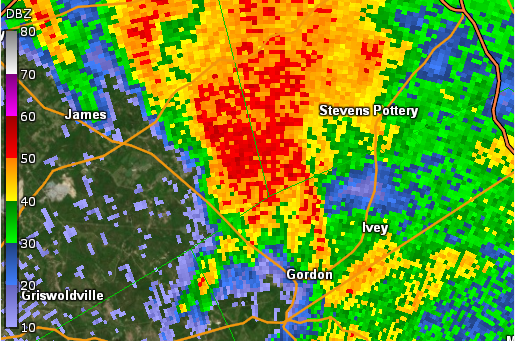
A brief tornado spun up in a rural area of southwest Baldwin County and tracked across the Jones County line before lifting. A Tornado Debris Signature (TDS) was seen from the KJGX 88-D radar at approximately 10:31 UTC on August 17, 2021. Multiple trees were snapped along Union Hill Church Road near Kitchens Road with additional reports of trees down along County Line Road near Piney Woods Drive. The TDS likely resulted from the tornado affecting a heavily wooded area between Union Hill Church Road and County Line Road, along the Baldwin/Jones county line. Estimate maximum winds were around 75 mph in this area.
|
|
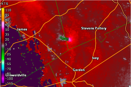 |
| KJGX Reflectivity (6:29 AM EDT) | KJGX base velocity (6:29 AM EDT) |
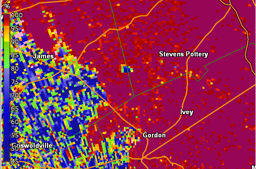 |
| KJGX Correlation Coefficient (6:30 AM EDT) |
Current Hazards
Nationwide
Local Storm Reports
Local
Submit Storm Report
Outlooks
Georgia Road Conditions
Forecasts
Local
Computer Models
Graphical
Aviation Weather
Activity Planner
Recreational Forecast
Fire Weather
Forecast Discussion
Incident Support
Tropical Weather
Current Weather
Satellite Images
Observations
Maps
Rivers/Lakes
Radar Imagery
Nationwide
Warner Robins
Peachtree City
Regional Loop
US Dept of Commerce
National Oceanic and Atmospheric Administration
National Weather Service
Atlanta/Peachtree City, GA
4 Falcon Drive
Peachtree City, GA 30269
770.486.1133
Comments? Questions? Please Contact Us.