Atlanta/Peachtree City, GA
Weather Forecast Office
January 5-7, 2009 |
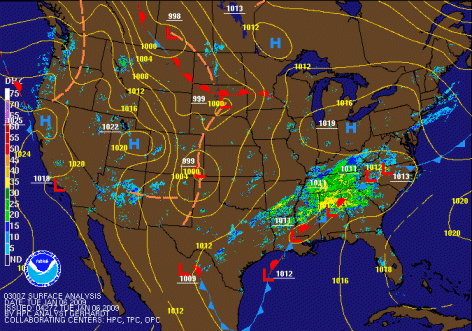
When a frontal system stalls across the southeastern part of the nation, and strong south to southwest winds aloft bring abundant moisture up from the Gulf of America, the result can be an extended period of moderate to heavy rain. This was the case from January 5 through January 7, 2009 when portions of North Georgia received several inches of rain. The bulk of the rain started on the evening of the 5th and continued in waves through the night of the 6th. Most locations along and north of a line from Cedartown in Polk County to Homer in Banks County recorded a two-day total of 3.5 to 5.5 inches. A few locations reported 6 to 7 inches - including Plant Hammond, in western Floyd County. This resulted in widespread flooding of creeks and streams. Some roads were closed at times by either high water, or debris. An example of the flooding was provided by a CoCoRaHS observer near Adairsville in Bartow County.
Here is a breakdown of rainfall amounts by location. [ pdf ] 
For current conditions of rivers and streams across Georgia, visit our AHPS page.
Warnings can be viewed from this page.
Current Hazards
Local
Submit Storm Report
Outlooks
Georgia Road Conditions
Nationwide
Local Storm Reports
Forecasts
Aviation Weather
Activity Planner
Recreational Forecast
Fire Weather
Forecast Discussion
Incident Support
Tropical Weather
Local
Computer Models
Graphical
Current Weather
Maps
Rivers/Lakes
Satellite Images
Observations
Radar Imagery
Warner Robins
Peachtree City
Regional Loop
Nationwide
US Dept of Commerce
National Oceanic and Atmospheric Administration
National Weather Service
Atlanta/Peachtree City, GA
4 Falcon Drive
Peachtree City, GA 30269
770.486.1133
Comments? Questions? Please Contact Us.


![[ rainfall totals from 5 pm January 5 to 5 pm January 7, 2009 ]](/images/ffc/events/rainjan609/jan609total.gif)
![[ Flooding on Dry Creek. ]](/images/ffc/events/rainjan609/jan609sm.jpg)
![[ Flooding on Dry Creek - driveway washing out at 70 Doris Road NW Adairsville ]](/images/ffc/events/rainjan609/jan609asm.jpg)
![[ Flooding on Dry Creek - Wayside Road NW just north of Doris Road NW Adairsville. ]](/images/ffc/events/rainjan609/jan609bsm.jpg)