Heavy Rainfall and Near Winter Event Across North Georgia
January 14-18, 2013
Synopsis
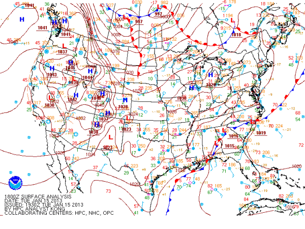
A slow moving to nearly stationary cold front combined with ample moisture streaming in from both the Pacific and off the Gulf of America combined to set up a heavy rainfall mainly across Northwest GA during the week of January 14-18, 2013. This Pacific plume became a mainstay across the region during the week and as small disturbances moved through this southwest flow aloft, several rainfall episodes occurred across the northwest portion of the state. Computer models were in remarkable agreement on this scenario and aligned very well with regards to the location of the axis of heaviest rainfall leading up to this event. This setup also featured a significant southern ice storm across portions of TX, LA, AR, MS, TN and northern AL as arctic air filtered southward in behind the stationary cold front (figure1). Toward the conclusion of the event, a strong upper level low was forecast to move across the southern tier of states basically along the Interstate 20 corridor and bring bands of snow particularly north and west of the track of the upper low in what is commonly referred to as the deformation zone (figure 5). North and northwest GA was expected to receive some of this wintry weather, however, that did not occur as much as expected by most computer models because the upper level low began to fill (or weaken) rapidly as it approached and the surface temperatures did not drop as much as was forecast by the models. As a result, the heavy snow bands which were steadily moving across AL during the afternoon of January 18 dissipated rapidly as they approached the north-central and northeast GA region. Still, some areas did receive some snowfall and there were many reports of black ice across northwest and northeast GA during the morning of Jan 18.
 |
|
Figure 1. The surface analysis from Tuesday January 15 shows the location of the stationary front across northwest GA. This front did not move much during the week and was the focus for much of the heavy rain that occurred. Also note the cold air behind the front across TX, LA and AR which combined with the moisture to produce significant icing across a large swath of southern states. |
Rainfall
The stationary front draped across the region combined with near record precipitable water values for the month of January provided the fuel for what would be a long duration rain event across north GA. Precipitable Water(PW) is a measure of the total water content in the atmosphere. For January, PW averages around 0.50 inches, but on Monday January 14th at 12Z, the FFC sounding measured 1.66 inches which is the maximum ever observed in the month of January at FFC. These factors led to a high confidence forecast that heavy rainfall would occur in north GA. The images below show both the forecast rain amounts at the beginning of the week and the observed rainfall at the end of the week. Flooding of creeks and streams occurred across many rivers and streams in north GA.
 |
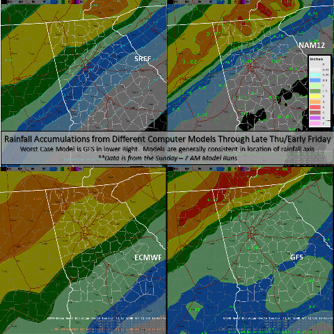 |
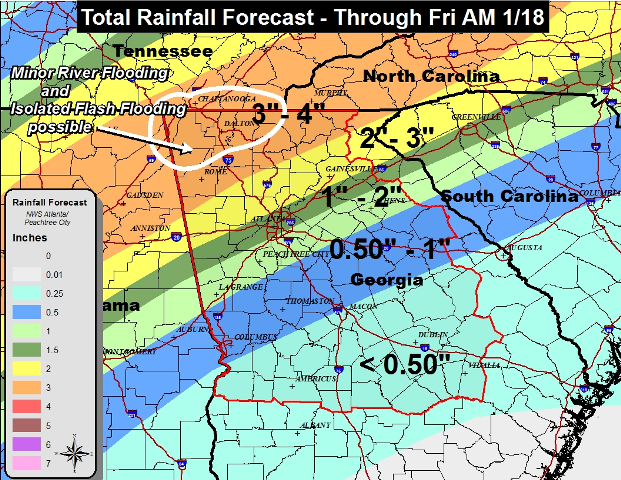
Figure 2. (Left) Shows the total official rainfall forecast at the start of the week issued Monday AM January 14. The image on the right shows 4 different computer model forecasts of total rainfall for the week which all key in on the northern part of the state. Data shown in the right image is based on the 12Z Monday January 14 models.
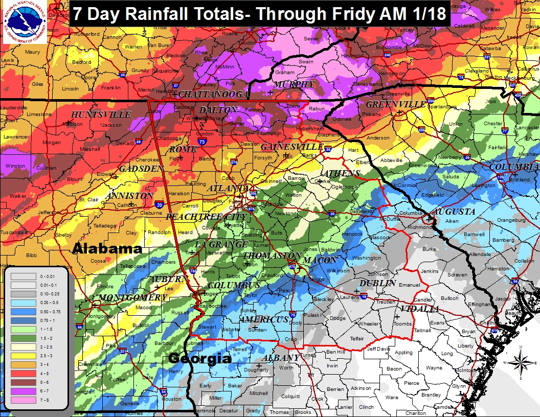 |
Figure 3. Shows the multisensor total rainfall for the 7 day period ending Friday January 18, 2013. The heaviest rainfall occurred in extreme north Georgia where some locations received just over 6". Most areas north and west of Interstate 85 received over 3 inches for the week. Meanwhile, areas across southeast Georgia, particularly south and east of a line from Albany to Dublin to Augusta received little or no rainfall during the week.
Winter Event
As the week progressed, it become more and more clear that winter weather would be possible during the day on Thursday. An upper level low pressure system was forecast to move across the southern states and tap much of the cold air and moisture already in place to produce a swath of snow from MS northeastward in the Appalachian Mountains. Figure 4 shows the potent upper level low over a water vapor image at 1 pm Thursday Jan 18.
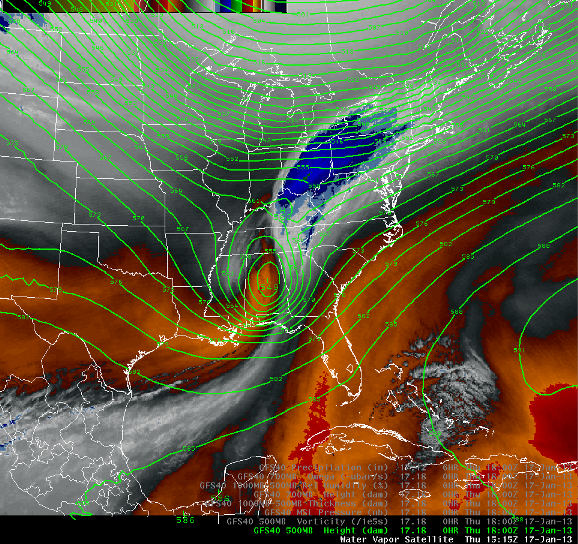 |
Figure 4. Water Vapor imagery and 500mb heights at 1 pm Thursday Jan 18 showing the location of the upper level low. Note the white area across MS to the west of the low. This is where the deformation zone was and the location of the heavy snow bands which produced several inches across MS and AL during the day.
|
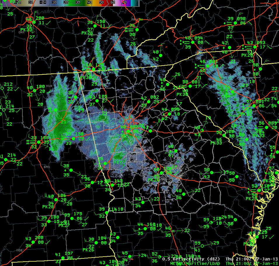
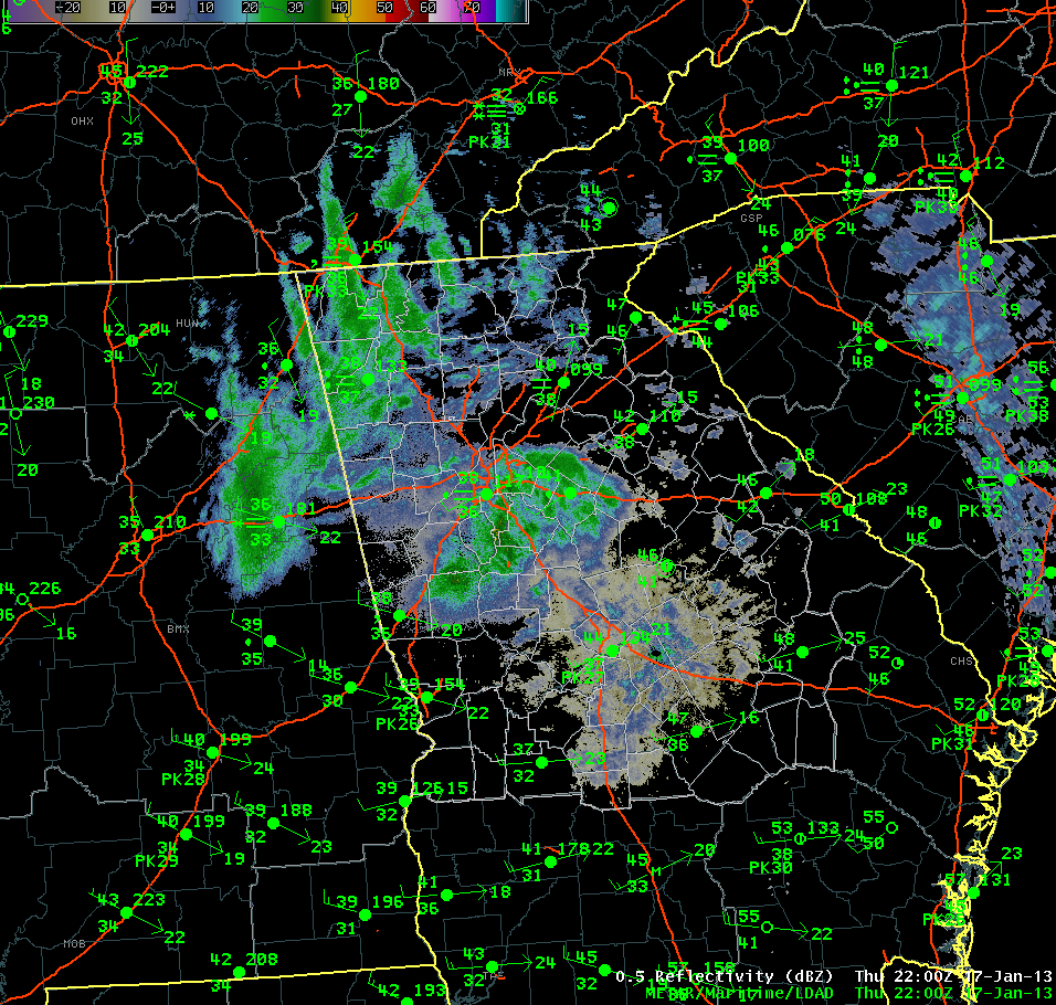
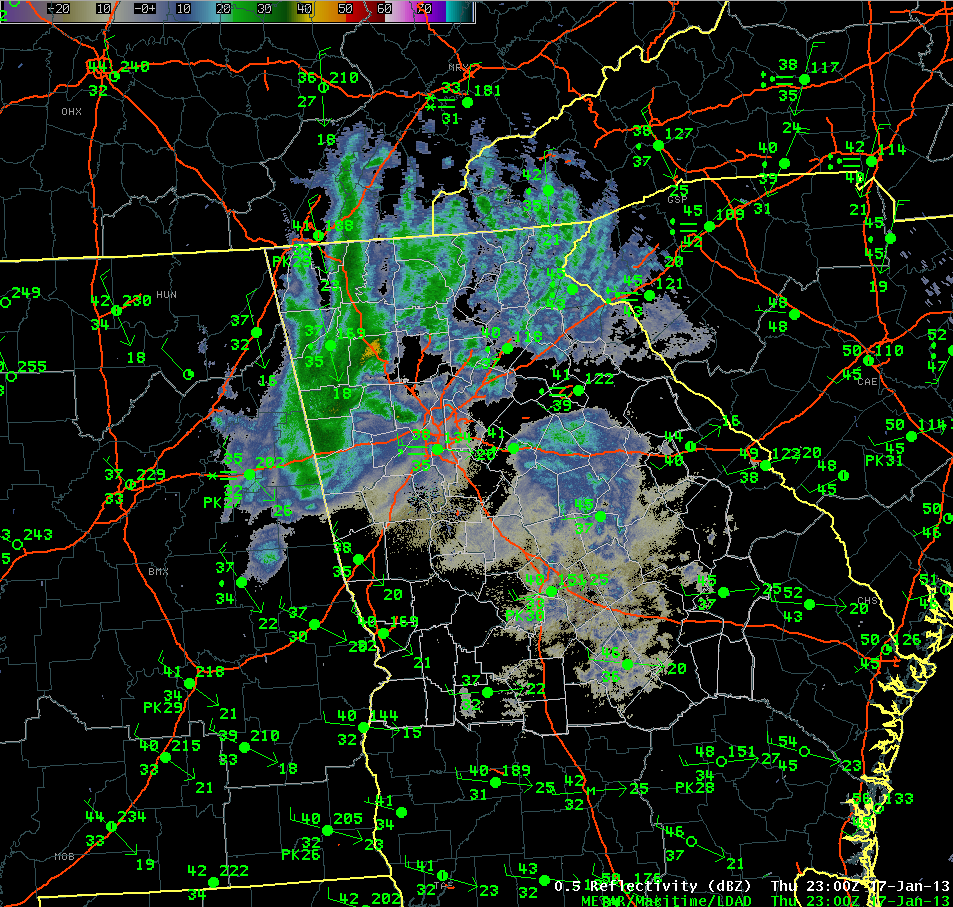
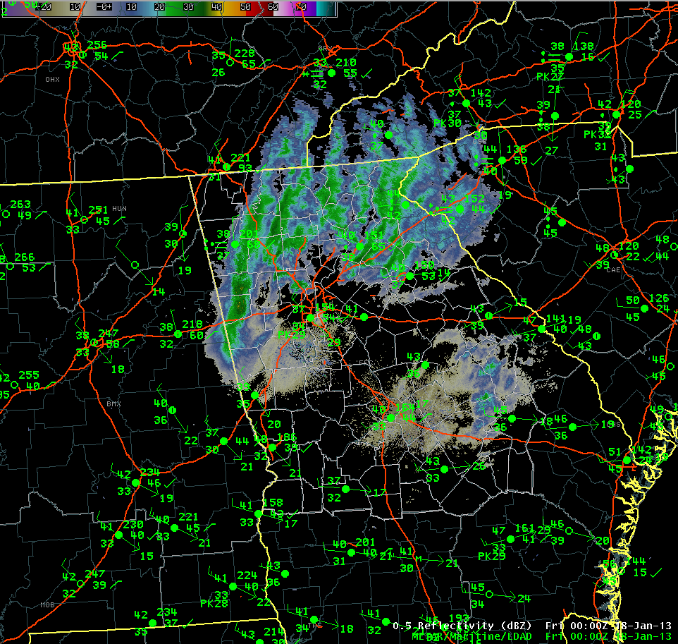
4 PM Thursday |
5 PM Thursday |
6 PM Thursday |
|
7 PM Thursday |
8 PM Thursday |
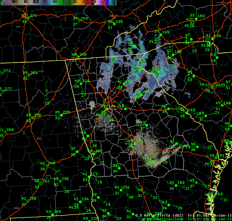
Figure 5. These 5 images show the progression of the snow bands across AL and into north GA. Note the snow in the observations in AL was occurring generally at temperatures at or above freezing. As this band moved into north GA, the temperature profile was not able to cool enough to allow the snow which was falling from the clouds to reach the ground as snow in many areas. As a result, the changeover took longer. At the same time, the upper level low was weakining as seen in the 7-8 PM images, the snow bands dissappated rapidly. |
Snow Totals (incomplete):
Not everyone missed out on the snow and ice however, some of the bands shown in the 6 and 7 PM radar images above produced moderate snow in western and northwestern GA. Black ice was reported across several areas, particularly from Cartersville, GA northeastward to Blairsville, GA. Some very isolated patches of black ice were reported in the Atlanta Metro area and several accidents were reported during the morning rush hour.
Cedartown - Polk County: 1.0 Inches was reported with several locations of black ice on the roadways early in the AM Friday Jan 18
Stephensville - Dade County: 1.0 inches reported, however, most of the snow melted shortly after it fell.
Bremen - Haralson County: 0.50 inches
Tallapoosa - Haralson County: 0.50 inches
|
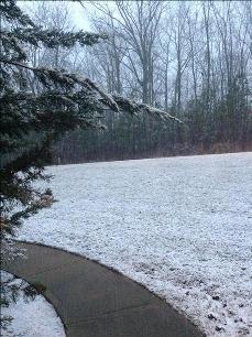
Snowfall in Haralson County Jan 17, 2013. Image courtesy WSB |
Snowfall in Cedartown, GA Jan 17, 2013. Image courtesy WSB |