Overview
|
After a derecho moved through the region on July 28, 2025, a second round of thunderstorms developed over central South Dakota late in the afternoon of the 29th. Several clusters of thunderstorms moves southeast through the evening hours. While these thunderstorms were not as organized and powerful as the storms the evening prior, they were capable or producing fairly widespread 60 to 75 mph wind gusts through the region. |
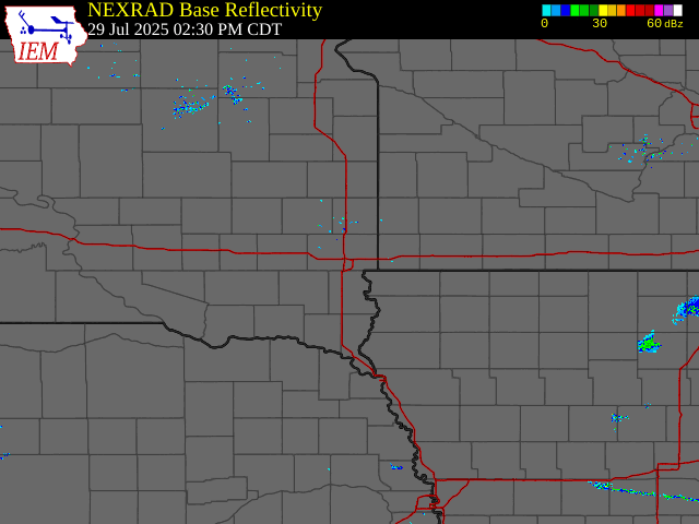 Radar Reflectivity - July 29, 2025 |
 |
 |
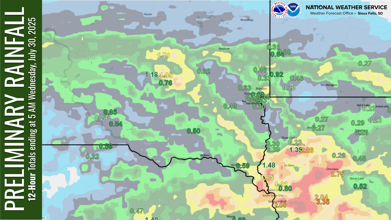 |
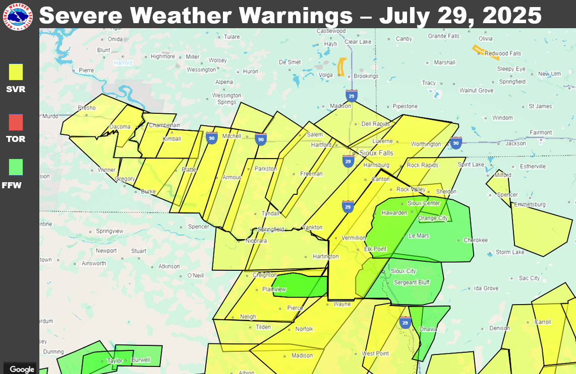
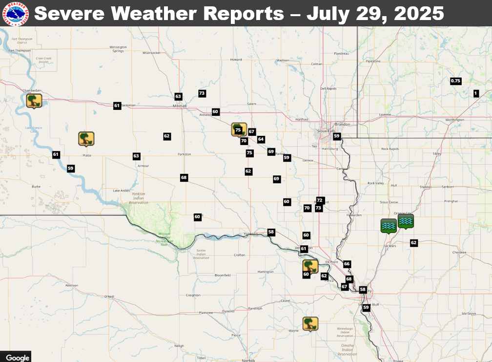
| Severe Weather Warnings - July 29, 2025 | Local Storm Reports - July 29, 2025 | Rainfall Totals July 29, 2025 |
Storm Reports
|
| Local Storm Reports - July 29, 2025 |
Preliminary Local Storm Report...Summary National Weather Service Sioux Falls SD 456 PM CDT Wed Jul 30 2025 ..TIME... ...EVENT... ...CITY LOCATION... ...LAT.LON... ..DATE... ....MAG.... ..COUNTY LOCATION..ST.. ...SOURCE.... ..REMARKS.. 0510 PM Tstm Wnd Dmg 5 S Chamberlain 43.74N 99.31W 07/29/2025 Brule SD CO-OP Observer Several trees blown over. Very strong winds tore off part of roof of house. 0542 PM Tstm Wnd Gst 14 W Platte 43.39N 99.12W 07/29/2025 M61 MPH Charles Mix SD Mesonet Mesonet station 154 SD RWIS Platte-Winner Bridge. 0546 PM Tstm Wnd Gst 9 SW Platte 43.30N 98.99W 07/29/2025 M59 MPH Charles Mix SD Mesonet Public Mesonet Wind Observation. 0608 PM Tstm Wnd Dmg 7 N Platte 43.49N 98.85W 07/29/2025 Charles Mix SD Trained Spotter Strong winds. Large healthy tree branch down, estimated 8-9 inches in diameter. Time estimated via radar. 0618 PM Tstm Wnd Gst 5 W Plankinton 43.71N 98.58W 07/29/2025 M60 MPH Aurora SD Mesonet Mesonet station 214 SD RWIS Plankinton. 0623 PM Tstm Wnd Gst 5 W Plankinton 43.71N 98.58W 07/29/2025 M61 MPH Aurora SD Mesonet Mesonet station 214 SD RWIS Plankinton. 0646 PM Tstm Wnd Gst 3 N Mitchell 43.77N 98.04W 07/29/2025 M63 MPH Davison SD ASOS ASOS station KMHE Mitchell Municipal Airport. 0652 PM Tstm Wnd Gst 3 S Corsica 43.38N 98.41W 07/29/2025 M63 MPH Douglas SD Mesonet Mesonet station 304 SD RWIS Corsica. 0658 PM Tstm Wnd Gst 8 WNW Dimock 43.51N 98.14W 07/29/2025 M62 MPH Davison SD Mesonet Reported via mobile mesonet on X. 0701 PM Tstm Wnd Gst 4 N Fulton 43.79N 97.83W 07/29/2025 M73 MPH Hanson SD Public Personal weather station. 0714 PM Tstm Wnd Gst 2 NW Tripp 43.24N 97.99W 07/29/2025 M61 MPH Hutchinson SD Mesonet Mesonet station 26 SD RWIS Tripp. 0715 PM Tstm Wnd Gst 4 ENE Alexandria 43.67N 97.71W 07/29/2025 M60 MPH Hanson SD Mesonet Mesonet station 213 SD RWIS Alexandria. 0720 PM Tstm Wnd Gst 2 NW Tripp 43.24N 97.99W 07/29/2025 M68 MPH Hutchinson SD Mesonet Mesonet station 26 SD RWIS Tripp. 0725 PM Hail 1 E Fulda 43.87N 95.59W 07/29/2025 M0.75 Inch Murray MN Public 0732 PM Tstm Wnd Gst 1 SW Tyndall 42.98N 97.87W 07/29/2025 M60 MPH Bon Homme SD Public Personal weather system. 0735 PM Tstm Wnd Dmg Bridgewater 43.55N 97.50W 07/29/2025 McCook SD Emergency Mngr Scattered tree damage throughout the city of Bridgewater. 0735 PM Tstm Wnd Gst Bridgewater 43.55N 97.51W 07/29/2025 E75 MPH McCook SD Emergency Mngr 0745 PM Tstm Wnd Gst 5 S Freeman 43.28N 97.42W 07/29/2025 M62 MPH Hutchinson SD Mesonet Mesonet station 163 SD RWIS Freeman. 0745 PM Tstm Wnd Gst 4 W Dolton 43.48N 97.46W 07/29/2025 M70 MPH Hutchinson SD Public Personal weather station. 0745 PM Hail 4 W Heron Lake 43.79N 95.41W 07/29/2025 M1.00 Inch Jackson MN Public 0749 PM Tstm Wnd Gst 4 NNE Freeman 43.40N 97.41W 07/29/2025 M75 MPH Hutchinson SD Public Personal weather station. 0750 PM Tstm Wnd Gst 4 N Dolton 43.54N 97.39W 07/29/2025 M67 MPH McCook SD Mesonet Mesonet station 322 SD RWIS STANLEY CORNER. 0800 PM Tstm Wnd Gst 2 ESE Marion 43.41N 97.22W 07/29/2025 M69 MPH Turner SD Public Personal weather station. 0805 PM Tstm Wnd Gst 4 E Dolton 43.49N 97.31W 07/29/2025 M64 MPH Turner SD Public Personal weather station. 0806 PM Tstm Wnd Gst 5 SW Hurley 43.23N 97.17W 07/29/2025 E69 MPH Turner SD Mesonet First severe gust at 806 pm, peak of 69 mph at 816 pm. Hurley SDSU Mesonet site. 0830 PM Tstm Wnd Gst 3 ESE Parker 43.37N 97.08W 07/29/2025 M59 MPH Turner SD Mesonet Mesonet station 310 SD RWIS Parker. 0833 PM Tstm Wnd Gst 4 WSW Rowena 43.51N 96.64W 07/29/2025 M59 MPH Minnehaha SD Public Personal weather station. 0848 PM Tstm Wnd Gst 4 E Irene 43.08N 97.08W 07/29/2025 M60 MPH Turner SD Mesonet Mesonet station 320 SD RWIS IRENE. 0851 PM Tstm Wnd Gst 3 SSW Beresford 43.04N 96.80W 07/29/2025 M63 MPH Union SD Mesonet Mesonet station 16 SD RWIS Beresford. 0851 PM Tstm Wnd Gst 6 SSE Centerville 43.04N 96.90W 07/29/2025 M70 MPH Clay SD Mesonet Mesonet station BFMS2 Beresford 7 WSW (SD Mesonet). 0852 PM Tstm Wnd Gst 1 SSW Vermillion 42.77N 96.93W 07/29/2025 M61 MPH Clay SD AWOS AWOS station KVMR Vermillion. 0854 PM Tstm Wnd Gst 1 NW Beresford 43.09N 96.79W 07/29/2025 M72 MPH Lincoln SD Public Personal weather station. 0855 PM Tstm Wnd Gst 2 WSW Gayville 42.88N 97.22W 07/29/2025 M58 MPH Yankton SD Mesonet Mesonet station 197 SD RWIS Gayville. 0857 PM Tstm Wnd Gst 1 NNE Beresford 43.09N 96.78W 07/29/2025 M66 MPH Lincoln SD Public Personal weather station. 0857 PM Tstm Wnd Gst 6 N Vermillion 42.86N 96.91W 07/29/2025 M60 MPH Clay SD Public Personal weather station. 0900 PM Tstm Wnd Dmg Newcastle 42.65N 96.87W 07/29/2025 Dixon NE Trained Spotter NE Highway 12 blocked by several large trees down in Newcastle. 0905 PM Tstm Wnd Gst 3 SSW Beresford 43.04N 96.80W 07/29/2025 M73 MPH Union SD Mesonet Mesonet station 16 SD RWIS Beresford. 0915 PM Tstm Wnd Gst 3 NW Ponca 42.59N 96.75W 07/29/2025 M62 MPH Dixon NE Public Personal weather station. 0925 PM Tstm Wnd Dmg Wakefield 42.27N 96.87W 07/29/2025 Dixon NE CO-OP Observer Large section of a 50-60 foot tree down at the cemetery. Other spotty wind damage around town to tree limbs. 0925 PM Tstm Wnd Gst 1 E Remsen 42.81N 95.96W 07/29/2025 M62 MPH Plymouth IA Public Personal weather station. 0933 PM Tstm Wnd Gst 4 WSW North Sioux City 42.52N 96.57W 07/29/2025 M67 MPH Union SD Public Personal weather station. 0935 PM Tstm Wnd Gst 3 SE Jefferson 42.57N 96.53W 07/29/2025 M68 MPH Union SD Dept of Highways Mesonet station 53 SD RWIS North Sioux City. 0937 PM Tstm Wnd Gst 4 SSW Newcastle 42.60N 96.91W 07/29/2025 M60 MPH Dixon NE Public Personal weather station. 0942 PM Tstm Wnd Gst 6 SSE Westfield 42.67N 96.55W 07/29/2025 M66 MPH Plymouth IA Mesonet Personal weather station. 0959 PM Tstm Wnd Gst 1 WSW Sioux City 42.50N 96.41W 07/29/2025 M58 MPH Woodbury IA Public Personal weather station. 1001 PM Tstm Wnd Gst 2 SW Sergeant Bluff 42.38N 96.38W 07/29/2025 M59 MPH Woodbury IA ASOS ASOS station KSUX Sioux Gateway Airport. 1221 AM Flash Flood 3 SSW Alton 42.95N 96.03W 07/30/2025 Sioux IA Law Enforcement Hwy 60 near 480th closed due the roadway being flooded. 0205 AM Flash Flood 2 NNE Struble 42.92N 96.18W 07/30/2025 Sioux IA Other Federal The Floyd River near Struble rose nearly 8 feet in 3 hours to flood stage. |
 |
Media use of NWS Web News Stories is encouraged! Please acknowledge the NWS as the source of any news information accessed from this site. |
|


 Weather Story
 Weather Map
 Local Radar