
A significant heat wave is underway for the Intermountain West, Northern Plains, and Upper Great Lakes, peaking in intensity through midweek and lingering across parts of the Northern Plains and Midwest until this weekend. In southwest Texas, excessive rainfall may bring a risk for potentially life-threatening flash and arroyo flooding through Thursday. Read More >

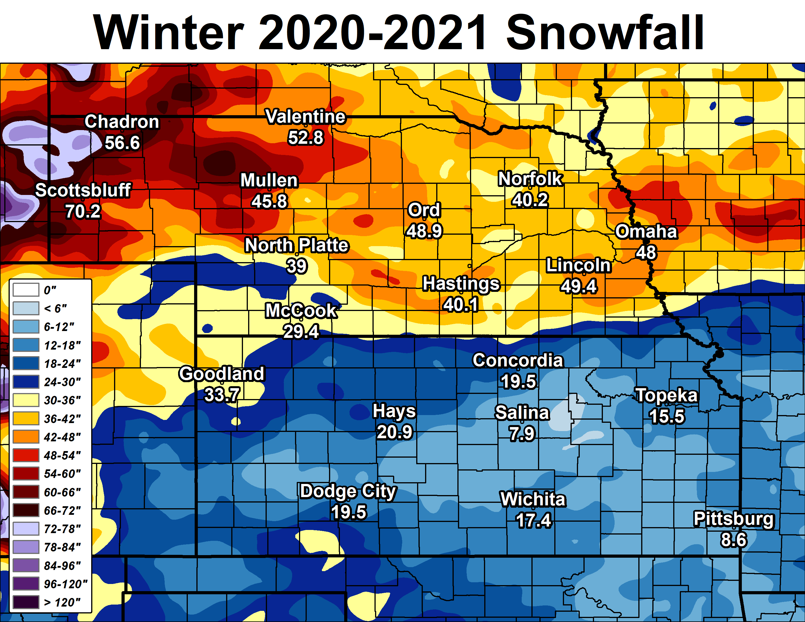
Now that the calendar has flipped to November and parts of our 30-county coverage area have already seen their first wet/slushy snow of the season, it's time to rewind and examine last winter's snow season (Oct. 2020-April 2021). As covered in more detail below, the most "notable thing" about last winter was a fairly sharp divide in snow totals between our Nebraska coverage area (most areas 10-15" ABOVE normal) and our Kansas coverage area (most places near-normal).
Below are various graphics and tables that outline seasonal totals, departures from normal/average etc. for the preceding
2020-21 snow season. Before continuing though, and in order to give last season's totals some perspective, official 30-year normals/averages for our area are:
"Normal"/average seasonal snowfall within our coverage area (based on 1991-2020 NCEI data):
** Note: You can access daily and seasonal local snow total maps (updated DAILY) at this page: https://www.weather.gov/gid/Snow
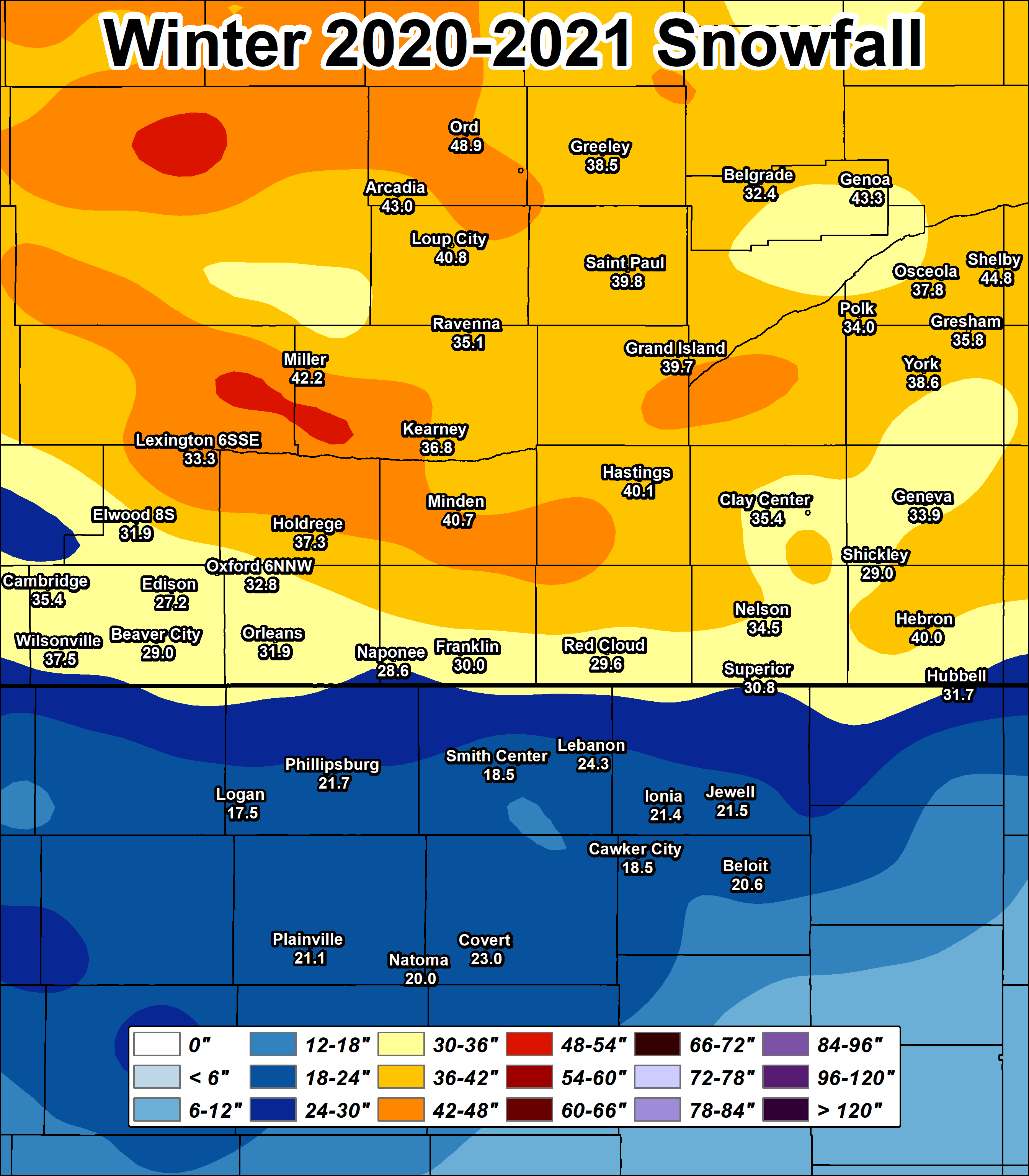
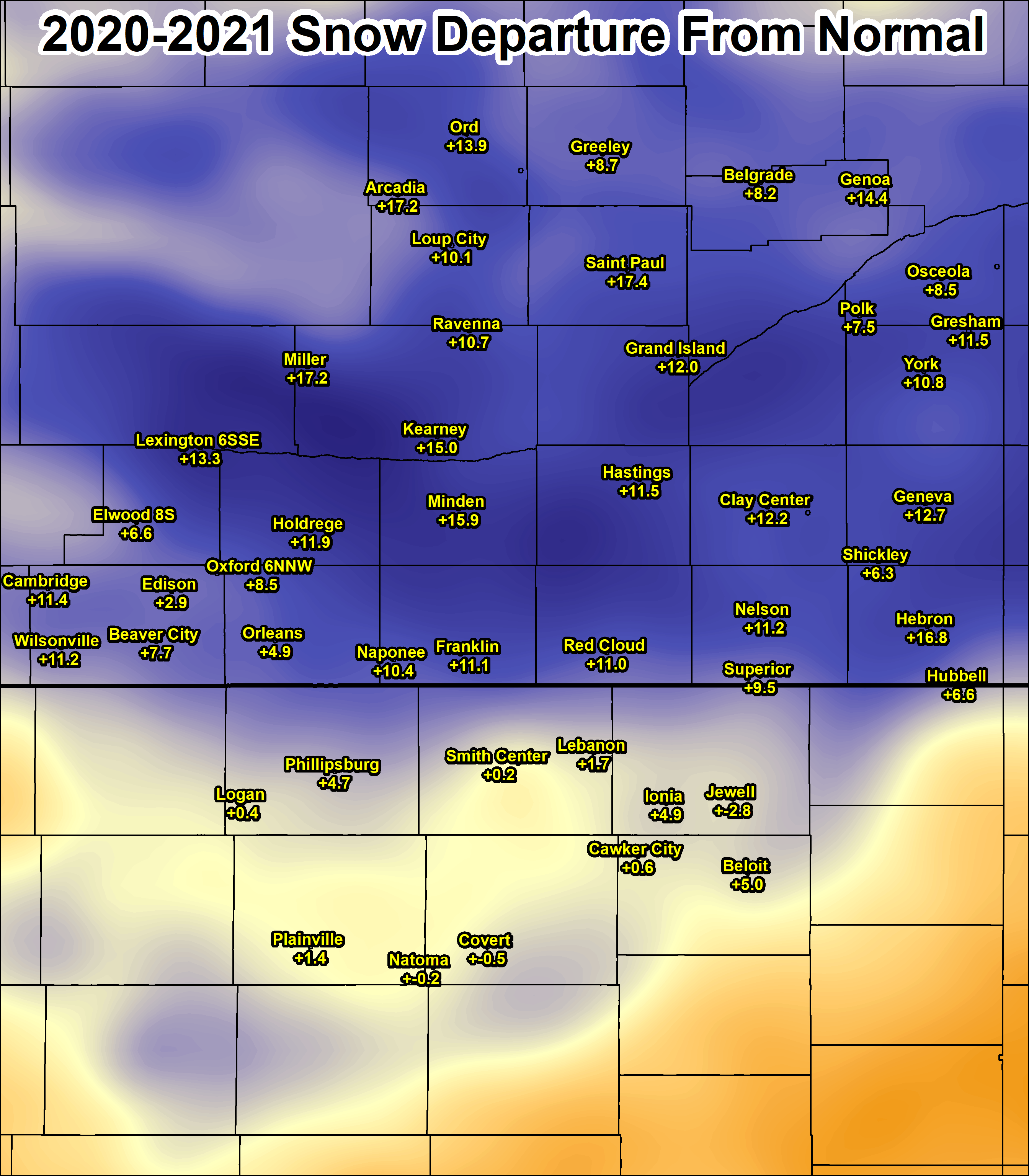
NWS Hastings Coverage Area (24 Nebraska counties/6 Kansas counties)
2020-21 Seasonal Snow and Departure From Normal
(click image to enlarge)
 |
 |
| LOCAL 2020-21 Snow Season Totals | LOCAL 2020-21 Snow Departure From Normal |
Regional (Central Plains)
2020-21 Seasonal Snow and Departure From Normal
(click image to enlarge)
 |
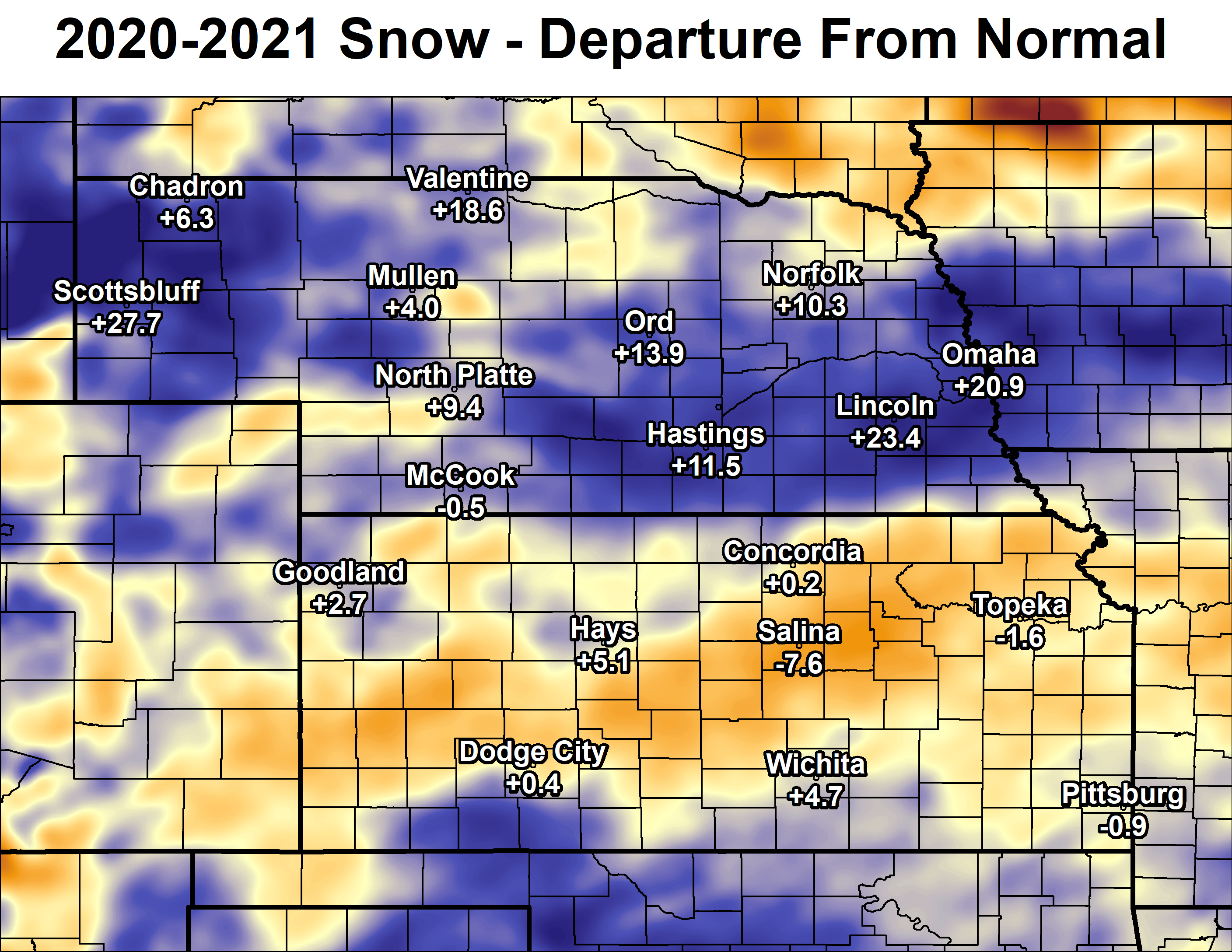 |
| REGIONAL 2020-21 Snow Season Totals | REGIONAL 2020-21 Snow Departure From Normal |
WINTER 2020-2021 SOUTH CENTRAL NEBRASKA
NWS COOP OBSERVER SNOWFALL
The highest reported amount under each month indicated in BLUE, the lowest amount in RED.
T* indicates hail was reported during the month.
| Station | Sep | Oct | Nov | Dec | Jan | Feb | Mar | Apr | May | Season |
| Arcadia 2W | 0.0 | 4.6 | 2.1 | 10.4 | 11.0 | 14.2 | 0.7 | T | 0.0 | 43.0 |
| Beaver City | 0.0 | 2.0 | 0.4 | 7.1 | 9.0 | 9.5 | 0.0 | 1.0 | 0.0 | 29.0 |
| Belgrade | T* | 4.2 | 2.5 | 8.4 | 8.0 | 9.3 | 0.0 | T | 0.0 | 32.4 |
| Blue Hill 4SW | 0.0 | MSG | 0.4 | 8.3 | MSG | MSG | MSG | MSG | MSG | MSG |
| Cambridge | 0.0 | 3.0 | 0.5 | 10.9 | 8.0 | 10.0 | T | 3.0 | T* | 35.4 |
| Lexington 6SSE (Canaday) | 0.0 | 1.0 | 1.0 | 11.5 | 7.0 | 12.7 | 0.0 | 0.1 | 0.0 | 33.3 |
| Clay Center 6ESE | 0.0 | 1.8 | T | 7.2 | 13.0 | 13.5 | 0.0 | 0.3 | T* | 35.8 |
| Clay Center | 0.0 | 2.0 | T | 8.3 | 11.0 | 13.8 | 0.0 | 0.3 | 0.0 | 35.4 |
| Edison | 0.0 | 1.8 | 0.5 | 6.9 | 6.0 | 10.0 | T | 2.0 | 0.0 | 27.2 |
| Elwood 8S | 0.0 | 2.0 | 0.5 | 9.1 | 8.4 | 8.4 | T | 3.5 | 0.0 | 31.9 |
| Franklin | 0.0 | 1.5 | T | 3.5 | 8.5 | 13.5 | 0.0 | 3.0 | 0.0 | 30.0 |
| Geneva | 0.0 | 1.0 | 0.0 | 7.5 | 11.2 | 13.7 | 0.0 | 0.5 | 0.0 | 33.9 |
| Genoa 2W | 0.0 | 5.3 | 4.0 | 10.5 | 11.0 | 12.5 | 0.0 | T | 0.0 | 43.3 |
| Grand Island Airport | 0.0 | 0.7 | 0.8 | 12.0 | 12.6 | 13.4 | 0.0 | 0.2 | 0.0 | 39.7 |
| Greeley | 0.0 | 6.4 | 4.6 | 9.4 | 8.6 | 9.5 | 0.0 | T | 0.0 | 38.5 |
| Gresham 3W | 0.0 | 1.0 | T | 8.5 | 15.5 | 10.8 | 0.0 | T | 0.0 | 35.8 |
| Harlan County Lake | 0.0 | 3.0 | MSG | 3.9 | 10.0 | 15.0 | 0.0 | 3.0 | 0.0 | MSG |
| Hastings NWS | T* | 2.8 | 0.2 | 11.1 | 10.3 | 15.2 | 0.0 | 0.5 | 0.0 | 40.1 |
| Hebron | 0.0 | 0.3 | 0.0 | 5.6 | 13.4 | 18.7 | 0.0 | 2.0 | 0.0 | 40.0 |
| Holdrege | 0.0 | 2.0 | 1.0 | 12.8 | 10.0 | 8.5 | 0.0 | 3.0 | 0.0 | 37.3 |
| Hubbell | 0.0 | 0.2 | T | 4.5 | 12.5 | 12.5 | 0.0 | 2.0 | 0.0 | 31.7 |
| Kearney Airport | 0.0 | 2.0 | 0.8 | 11.0 | 7.7 | 12.0 | 0.0 | 3.3 | 0.0 | 36.8 |
| Loup City | 0.0 | 3.5 | 1.0 | 12.3 | 10.2 | 13.8 | 0.0 | T | 0.0 | 40.8 |
| Miller | 0.0 | 1.0 | 1.1 | 12.1 | 9.2 | 13.7 | 0.5 | 4.6 | 0.0 | 42.2 |
| Minden | 0.0 | 3.5 | 0.5 | 9.9 | 9.8 | 13.0 | 0.0 | 4.0 | T* | 40.7 |
| Naponee | 0.0 | 1.5 | 0.5 | 4.5 | 10.1 | 9.0 | 0.0 | 3.0 | 0.0 | 28.6 |
| Nelson | 0.0 | 0.4 | T | 5.5 | 11.6 | 14.6 | T | 2.4 | T* | 34.5 |
| North Loup | 0.0 | 6.1 | 2.5 | 9.0 | 9.2 | 11.5 | 0.0 | T | 0.0 | 38.3 |
| Orleans 1W | 0.0 | 2.8 | 0.4 | 6.3 | 10.1 | 9.9 | 0.0 | 2.4 | T* | 31.9 |
| Ord | 0.0 | 9.5 | 2.7 | 12.5 | 10.7 | 13.5 | T | T | 0.0 | 48.9 |
| Osceola | 0.0 | 1.2 | 1.4 | 13.5 | 11.4 | 10.1 | 0.0 | 0.2 | T* | 37.8 |
| Oxford 6NNW | 0.0 | 3.1 | 0.8 | 8.7 | 7.9 | 9.6 | 0.0 | 2.7 | 0.0 | 32.8 |
| Polk | 0.0 | 0.5 | 0.5 | 13.0 | 11.0 | 9.0 | 0.0 | T | 0.0 | 34.0 |
| Ravenna | 0.0 | 1.4 | 0.5 | 11.3 | 9.0 | 12.9 | 0.0 | T | 0.0 | 35.1 |
| Red Cloud | 0.0 | 0.5 | 0.0 | 3.0 | 10.1 | 14.0 | 0.0 | 2.0 | 0.0 | 29.6 |
| St. Paul | 0.0 | 0.9 | 2.3 | 13.0 | 9.9 | 13.7 | T | T | T* | 39.8 |
| Shelby 3NE | 0.0 | 1.4 | 1.1 | 16.1 | 11.0 | 15.2 | T | T | T* | 44.8 |
| Shickley 4S | 0.0 | T | T | 7.0 | 10.0 | 12.0 | 0.0 | T | T* | 29.0 |
| Superior | 0.0 | 0.5 | 0.0 | 4.5 | 10.8 | 11.7 | 0.0 | 3.3 | 0.0 | 30.8 |
| Wilsonville | 0.0 | 6.0 | 1.0 | 8.8 | 7.7 | 11.0 | 0.0 | 3.0 | 0.0 | 37.5 |
| York 3N | 0.0 | 1.2 | 0.4 | 10.5 | 13.9 | 12.5 | 0.0 | 0.1 | T* | 38.6 |
WINTER 2020-2021 NORTH CENTRAL KANSAS
NWS COOP OBSERVER SNOWFALL
The highest reported amount under each month indicated in BLUE, the lowest amount in RED.
T* indicated hail was reported during the month.
| Station | Sep | Oct | Nov | Dec | Jan | Feb | Mar | Apr | May | Season |
| Beloit | 0.0 | 1.0 | 0.0 | 0.6 | 11.0 | 4.0 | 0.0 | 4.0 | 0.0 | 20.6 |
| Burr Oak 1N | 0.0 | MSG | MSG | MSG | MSG | MSG | MSG | MSG | MSG | MSG |
| Cawker City | 0.0 | 2.0 | 0.0 | T | 9.5 | 3.0 | 0.0 | 4.0 | 0.0 | 18.5 |
| Covert Rural | 0.0 | 4.0 | 0.0 | 1.5 | 8.0 | 2.5 | 0.0 | 7.0 | 0.0 | 23.0 |
| Ionia | 0.0 | 1.5 | T | 0.9 | 11.3 | 4.7 | 0.0 | 3.0 | 0.0 | 21.4 |
| Jewell | 0.0 | 1.5 | 2.0 | 3.0 | 8.5 | 5.0 | 0.0 | 1.5 | T* | 21.5 |
| Kirwin Dam | 0.0 | 0.8 | T | 2.0 | 9.3 | 4.0 | 0.0 | 2.0 | 0.0 | 18.1 |
| Lebanon | 0.0 | T | T | 1.0 | 10.3 | 10.4 | 0.0 | 2.6 | 0.0 | 24.3 |
| Logan | 0.0 | 1.0 | T | 1.5 | 8.0 | 5.0 | 0.0 | 2.0 | 0.0 | 17.5 |
| Lovewell Dam | 0.0 | MSG | T | MSG | 16.3 | 7.3 | 0.0 | MSG | 0.0 | MSG |
| Natoma | 0.0 | 2.0 | 0.0 | 1.5 | 7.0 | 2.5 | 0.0 | 7.0 | 0.0 | 20.0 |
| Phillipsburg | 0.0 | 1.0 | T | 2.1 | 9.8 | 8.3 | 0.0 | 0.5 | T* | 21.7 |
| Plainville 4WNW | 0.0 | 1.9 | 0.0 | 2.4 | 9.2 | 1.2 | 0.0 | 6.4 | 0.0 | 21.1 |
| Smith Center | 0.0 | 0.6 | T | 1.8 | 9.3 | 5.1 | 0.0 | 1.7 | T* | 18.5 |
| Webster Dam | 0.0 | 1.0 | 0.0 | MSG | 7.0 | 2.0 | 0.0 | 3.0 | 0.0 | MSG |
The 2020-21 snowfall season (Oct. 2020-April 2021) was highlighted/defined by the following "fun facts":
Within our 24 South Central/Central Nebraska counties (per NWS observers): the highest 2020-21 seasonal snow totals were in our northern coverage area (as is typical), featuring 48.9" at Ord and 44.8" near Shelby, while the lowest totals (but still above normal) included 27.2" at Edison and 28.6" in Naponee.
Within our six North Central Kansas counties (per NWS observers): the highest 2020-21 seasonal totals featured 24.3" at Lebanon and 23.0" near Covert (rural Osborne County), while the lowest amounts included 17.5" at Logan and 18.5" in Smith Center and Cawker City.
In the Nebraska Tri Cities: official seasonal totals included: Hastings 40.1" (11.5" above normal)...Grand Island 39.7" (+12.0")...Kearney 36.8" (+15.0). At Kearney, this amount was very similar to the preceding 2019-20 season, but at Grand Island/Hastings these amounts were 9-11" more. In fact, the 2020-21 snowfall season was THE SNOWIEST SINCE
2009-10 for Grand Island/Hastings.
The EARLIEST MEASURABLE SNOW within our coverage area occurred between Oct. 18-19 (as much as 3-6" in Valley/Greeley counties) and the LATEST MEASURABLE SNOW occurred on April 19-20 (as much as 4-6" in parts of north central KS).
Chronological Breakdown of the 2020-21 Snow Season:
Oct-Dec. 2020: the season got off to a fairly slow start, with the majority of locations (except for a few mainly far northern counties) measuring no more than 1-4" through Dec. 10th. Things picked up a bit through the rest of December, with two systems each bringing a fairly widespread 2-8" to mainly our Nebraska coverage area (one centered Dec. 11 and the other Dec. 28th-29th).
 |
Media use of NWS Web News Stories is encouraged! Please acknowledge the NWS as the source of any news information accessed from this site. |
|

