
Scattered severe storms capable of large to very large hail, severe wind gusts, and a few tornadoes will be possible across the central Plains this evening. Heavy to excessive rainfall may bring a flooding threat from the Great Lakes to the Mid-South through tonight. Hot, dry and windy conditions will continue to bring a critical fire weather threat from the Southwest into the Great Basin. Read More >
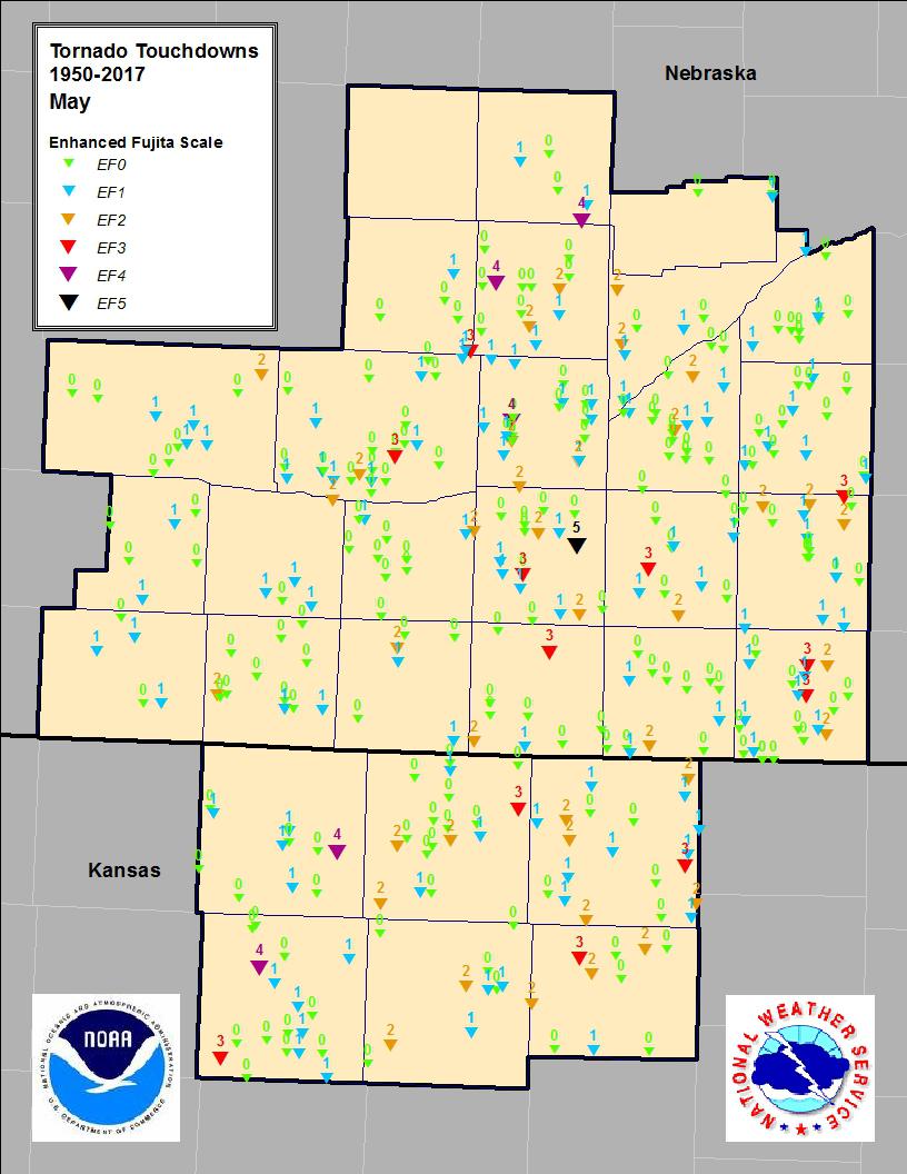
May Tornadoes
South Central Nebraska and North Central Kansas
(1950-2017)
| Tornado Touchdowns | Tornado Tracks |
 |
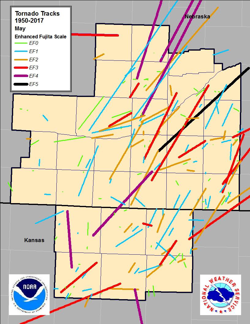 |
Tornado Descriptions (EF3 and Greater)
F5/EF5:
- May 5, 1964
Adams County: A tornado touched down near Hastings, NE and was visible from Harvard, Glitner, Hampton, Bradshaw, Benedict, Stromsburg, Shelby, and Rising City before lifting near Bellwood. There was complete destruction of all farmsites in the direct path. It was a large and intense tornado that completely destroyed at least a dozen of these farms within the first 30 miles. Two people were killed on a farm 3 NW of Bradshaw and 15 were injured at Shelby. As with most long track tornadoes in central Nebraska, this one seemed to be made up of a family of shorter track tornadoes. The width was generally 1/4 mile and sometimes 2-3 separate damaging funnels from the same cloud, which extended the width to 3/4 mile. Severe hail preceded, accompanied, and followed the funnel contact with the ground. After lifting near Bellwood, the tornado briefly touched the ground a few times in the next 40 miles. There was a heavy loss of livestock.
F4/EF4
- May 7, 1993
Osborne County: A tornado moved into Osborne County from Russell County, where it had caused significant damage, injuries and one fatality. The tornado dissipated in open country after hitting and destroying one farm house.
- May 10, 1985
Smith, Franklin, Phillips, Rooks Counties: A massive tornado dropped to the ground near Webster, KS and moved almost due north, finally lifting seven miles southwest of Woodruff. A good deal of damage was done to farm buildings, equipment, trees and power lines. Another large tornado touched down two miles south and two miles west of Agra. Moving to the north northeast, the twister passed just west of Agra, and then tore apart several farms north of town. The most extensive damage occurred 10 miles north northeast of town, where a farm home was leveled. Several farms sustained major damage, and one man was injured. Turning to the northeast, the tornado remained on the ground through the extreme northwest corner of Smith County, and entered Nebraska about 16 miles north of Kensington. The storm track covered 21 miles in Kansas, and another 35 miles after it entered Nebraska, ending just north of Blue Hill, NE. The heaviest damage in Nebraska was along the Republican River east of Franklin, where many trees were uprooted and a number of farmsteads were damaged.
- May 8, 1965
Hall and Howard Counties: A family of intense tornadoes formed in the center of Hall County and moved to the north northeast. The 120 mile path was close to Cairo, Dannebrog, St. Libory, St. Paul, Cushing, Wolbach, Petersburg, Elgin, Oakdale, Tilden, Plainview, Osmond, and Wausa. Evidence indicates that it was in contact with the ground for most of the 120 miles, but lifted briefly on several occasions.
- May 5, 1964
Greeley County: The tornado destroyed a major portion of Wolbach, and moved toward the northeast. It tracked for 60 miles into Boone and western Madison Counties. Several houses, school houses, and many farm buildings were destroyed.
​
F3/EF3
- May 11, 2014
Clay, Filmore & York Counties: Several tornadoes struck the area on Mother's Day 2014, including 2 EF-3 tornadoes in south-central Nebraska. The first tracked from 4.3 miles northwest of Fairfield to 4.8 miles northeast of Sutton, causing widespread property damage along its path and completely destroying a home north of Sutton. The second EF-3 tracked from near Exeter to near Goehner, leading to widespread damage along its path including complete destruction of one home.
- May 27, 2013
Smith & Jewell Counties: Multiple tornadoes occurred on Memorial Day 2013, including an EF-3 tornado that had a relatively short path from north of Lebanon, KS to near Esbon, KS. This tornado was responsible for heavy damage to 4 homesteads, major tree damage, overturned irrigation pivots, snapped power poles, and destroyed outbuildings.
- May 29, 2008
Mitchell County: A tornado moved out of Mitchell County and into Jewell County about 4 miles west of Highway 14. As the tornado moved northeast, and was southwest of the town of Jewell, KS, it hit three farmsteads and severely damaged the homes and outbuildings at these locations. One home was completely destroyed and the other had a machine shed destroyed. The tornado entered the southwest side of Jewell and moved across the west side of town. Several homes and businesses were damaged or destroyed. The Jewell Cafe and the Bourbon Trucking Company were destroyed. The town's water tower was also blown down by the tornado. The tornado lifted about two miles northeast of town.
- May 7, 1993
Webster County: The tornado touched down four miles south of Blue Hill, NE. Two farm houses and outbuildings were destroyed. The tornado moved north into southeast Adams County, where it damaged 75 to 100 homes in Ayr and Pauline. In southwest Clay County, the tornado derailed 25 cars from a train between Glenvill and Fairfield. A farm house, garage and grain bins were damaged near Glenvill. It moved north and lifted to a funnel cloud over northern Clay and southern Hamilton Counties, but touched down again just north of Interstate 80, where it destroyed three homes and one church. Other homes and outbuildings were damaged. The tornado was last spotted moving into western Polk County, northeast of Hordville.
- May 10, 1985
Buffalo County: A tornado touched down at intervals from five miles northeast of Kearney, NE, northeast to a point seven miles north of Shelton. At least 17 farms were hit, 12 farm homes damaged, and two demolished. Twop people sustained minor injuries at their homes. Numerous outbuildings were destroyed, trees uprooted, and crops damaged.
- May 8, 1965
Thayer County: A tornado skipped northeast from three miles east of Hebron, NE, leveling a barn three miles east of Ohiowa, and ending southwest of Pleasant Dale.
- May 9, 1953
Thayer County: The tornado tracked for 50 miles, moving north northeast from Hebron, NE to one mile east of Belvidere, passing near Ohiowa, three miles southeast of Friend, and four miles west of Milford. Homes, airplanes and hangars were destroyed. Five fatalities occurred in downtown Hebron, where 50 homes and 40 businesses were destroyed. The upper part of Hebron High School was torn off.

