
Dangerous heat will expand from the Gulf Coast into the Southern Plains and Desert Southwest through week's end. Additional extreme heat impacting the Pacific Northwest will shift to the northern Plains by the weekend. Tropical Storm Bertha is expected to continue to impact portions of the northern Gulf Coast from the western Florida Panhandle to southeastern Louisiana through tonight. Read More >
Overview/Narrative:
(BE SURE TO CLICK THE VARIOUS TABS BELOW FOR A VARIETY OF MAY 2018 CLIMATE INFORMATION!)
|
Recap of May 2018 Weather for the 30-county NWS Hastings Coverage Area:
|
Grand Island & Hastings Details (Including 12-Month History):
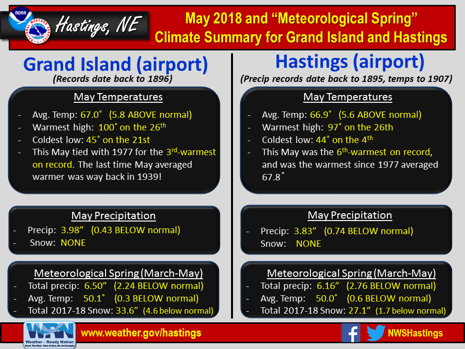 |
| Detailed May 2018 info for Grand Island/Hastings (Click to enlarge) |
 |
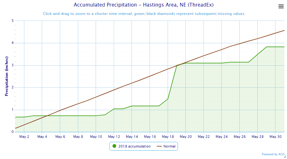 |
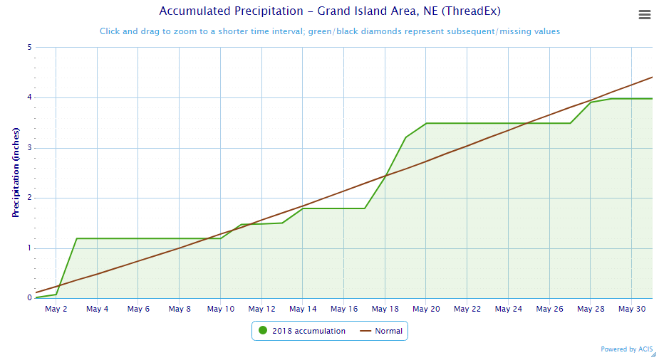
| Grand Island Precipitation Summary: The green line indicates cumulative observed precipitation for May 2018.The brown line indicates "normal" May precipitation based on 30-year data from 1981-2010. (click to enlarge) | Hastings Precipitation Summary: The green line indicates cumulative observed precipitation for May 2018. The brown line indicates "normal" May precipitation based on 30-year data from 1981-2010. (click to enlarge) |
| Grand Island (Regional Airport ASOS) - June 2017 - May 2018 | ||||||||||||
| June | July | Aug. | Sep. | Oct. | Nov. | Dec. | Jan. | Feb. | Mar. | Apr. | May | |
| Average High (F) | 87.5 | 88.9 | 81.3 | 80.5 | 65.2 | 53.4 | 37.3 | 34.0 | 33.6 | 51.8 | 55.4 | 78.6 |
| Average Low (F) | 61.2 | 66.6 | 58.9 | 55.0 | 40.2 | 28.7 | 16.0 | 13.5 | 12.5 | 28.8 | 30.8 | 55.5 |
| Average Temperature (F) | 74.4 | 77.8 | 70.1 | 67.8 | 52.7 | 41.1 | 26.6 | 23.7 | 23.1 | 40.3 | 43.1 | 67.0 |
| Departure From Normal | +3.1 | +1.6 | -3.9 | +2.7 | +0.5 | +3.0 | -0.1 | -1.4 | -6.0 | +0.9 | -7.5 | +5.8 |
| Precipitation (in) | 2.10 | 3.05 | 6.19 | 2.68 | 5.36 | 0.51 | 0.45 | 1.08 | 0.75 | 1.26 | 1.26 | 3.98 |
| Departure From Normal | -2.20 | -0.35 | +3.07 | +0.45 | +3.50 | -0.66 | -0.18 | +0.55 | +0.07 | -0.54 | -1.27 | -0.43 |
| Snowfall (in) | 0.0 | 0.0 | 0.0 | 0.0 | 0.9 | 0.2 | 7.2 | 10.2 | 10.6 | 0.4 | 4.1 | 0.0 |
| Departure From Normal | 0.0 | 0.0 | 0.0 | -0.1 | -0.1 | -2.9 | +2.1 | +3.7 | +4.3 | -5.0 | +2.6 | 0.0 |
| Hastings (Municipal Airport ASOS) - June 2017 - May 2018 | ||||||||||||
| June | July | Aug. | Sep. | Oct. | Nov. | Dec. | Jan. | Feb. | Mar. | Apr. | May | |
| Average High (F) | 86.3 | 88.9 | 81.7 | 81.2 | 64.9 | 53.1 | 37.9 | 35.3 | 34.3 | 52.3 | 55.6 | 78.2 |
| Average Low (F) | 62.1 | 67.6 | 59.8 | 55.9 | 40.8 | 28.6 | 15.9 | 14.3 | 12.4 | 27.8 | 30.6 | 55.6 |
| Average Temperature (F) | 74.2 | 78.2 | 70.7 | 68.6 | 52.9 | 40.9 | 26.9 | 24.8 | 23.4 | 40.1 | 43.1 | 66.9 |
| Departure From Normal | +2.4 | +1.1 | -3.6 | +3.0 | +0.3 | +2.2 | -0.7 | -1.2 | -6.5 | +0.2 | -7.6 | +5.6 |
| Precipitation (in) | 1.79 | 4.71 | 5.10 | 2.18 | 4.69 | 0.08 | 0.28 | 0.49 | 0.53 | 1.07 | 1.26 | 3.83 |
| Departure From Normal | -2.01 | +0.97 | +1.80 | -0.38 | +2.70 | -1.21 | -0.33 | +0.08 | +0.04 | -0.72 | -1.30 | -0.74 |
| Snowfall (in) | 0.0 | 0.0 | 0.0 | 0.0 | 0.2 | 0.0 | 5.8 | 5.9 | 8.0 | 0.3 | 6.9 | 0.0 |
| Departure From Normal | 0.0 | 0.0 | 0.0 | -0.2 | -1.0 | -2.6 | -0.3 | -0.1 | +1.5 | -4.9 | +5.7 | 0.0 |
Kearney - 12 Month Climate History:
All data here is from the official NWS observer at Kearney airport, with 24-hour observations taken around 7 a.m. ** PLEASE NOTE: This official Kearney data often differs slightly from the unofficial data recorded by the automated airport system (KEAR) **
| Kearney Airport (Coop Observer) - June 2017 - May 2018 | ||||||||||||
| June | July | Aug. | Sep. | Oct. | Nov. | Dec. | Jan. | Feb. | Mar. | Apr. | May | |
| Average High (F) | 86.6 | 88.1 | 81.2 | 80.7 | 65.9 | 52.3 | 38.7 | 32.2 | 32.9 | 51.9 | 53.8 | 75.9 |
| Average Low (F) | 59.7 | 64.8 | 56.9 | 52.6 | 40.0 | 26.8 | 15.5 | 11.1 | 10.6 | 26.1 | 28.6 | 52.7 |
| Average Temperature (F) | 73.2 | 76.5 | 69.1 | 66.6 | 53.0 | 39.6 | 27.1 | 21.6 | 21.7 | 39.0 | 41.2 | 64.3 |
| Departure From Normal | +3.4 | +1.8 | -3.5 | +3.1 | +2.1 | +2.6 | +1.2 | -3.0 | -6.4 | +1.3 | -7.5 | +4.8 |
| Precipitation (in) | 1.93 | 3.66 | 3.65 | 2.19 | 2.83 | 0.34 | 0.21 | 0.96 | 0.73 | 1.05 | 2.03 | 5.56 |
| Departure From Normal (in) | -2.00 | +0.38 | +0.57 | +0.12 | +0.79 | -0.68 | -0.36 | +0.47 | +0.18 | -0.74 | -0.20 | +1.38 |
| Snowfall (in) | 0.0 | 0.0 | 0.0 | 0.0 | 0.0 | 0.4 | 4.3 | 6.8 | 9.2 | 0.7 | 9.7 | 0.0 |
| Departure From Normal (in) | 0.0 | 0.0 | 0.0 | -0.2 | -0.7 | -2.7 | +0.8 | +2.4 | +4.1 | -3.9 | +7.9 | 0.0 |
Ord - 12 Month Climate History:
Winter precipitation totals often include NWS Cooperative Observer data due to the automated airport equipment under-measuring snowfall liquid equivalent.
| Ord (Evelyn Sharp Field ASOS) - June 2017 - May 2018 | ||||||||||||
| June | July | Aug. | Sep. | Oct. | Nov. | Dec. | Jan. | Feb. | Mar. | Apr. | May | |
| Average High (F) | 86.3 | 90.3 | 81.4 | 78.0 | 63.7 | 53.4 | 36.6 | 34.3 | 31.2 | 49.9 | 54.1 | 75.4 |
| Average Low (F) | 56.9 | 64.1 | 56.3 | 51.2 | 36.1 | 24.3 | 14.1 | 10.2 | 9.0 | 25.5 | 27.3 | 51.8 |
| Average Temperature (F) | 71.6 | 77.2 | 68.8 | 64.6 | 49.9 | 38.9 | 25.3 | 22.2 | 20.1 | 37.7 | 40.7 | 63.6 |
| Departure From Normal | +2.4 | +2.8 | -4.2 | +1.0 | +0.3 | +2.6 | +0.4 | -2.4 | -7.7 | 0.0 | -8.1 | +4.3 |
| Precipitation (in) | 0.59 | 2.53 | 5.93 | 2.89 | 5.37 | 0.21 | 0.43 | 0.83 | 0.53 | 0.62 | 1.47 | 4.38 |
| Departure From Normal (in) | -3.53 | -0.44 | +2.77 | +0.45 | +3.44 | -0.86 | -0.16 | +0.46 | +0.09 | -0.83 | -1.12 | +0.57 |
| Snowfall (in) | 0.0 | 0.0 | 0.0 | 0.0 | 0.0 | 2.0 | 5.3 | 12.4 | 8.6 | 1.1 | 10.1 | 0.0 |
| Departure From Normal (in) | 0.0 | 0.0 | 0.0 | 0.0 | -1.1 | -3.3 | -2.1 | +5.6 | +2.6 | -4.8 | +7.6 | 0.0 |
Smith Center, KS - 12 Month Climate History:
All data is from the official NWS observer, with 24-hour observations taken around 7 a.m. As a result, data may vary slightly from true "Calendar Day" totals.
| Smith Center KS (NWS Coop Observer) - June 2017 - May 2018 | ||||||||||||
| June | July | Aug. | Sep. | Oct. | Nov. | Dec. | Jan. | Feb. | Mar. | Apr. | May | |
| Average High (F) | 89.8 | 95.2 | 86.4 | 85.6 | 70.5 | 55.9 | 43.6 | 39.1 | 39.4 | 57.8 | 58.4 | 82.7 |
| Average Low (F) | 60.9 | 66.7 | 59.9 | 56.0 | 40.1 | 28.5 | 17.6 | 12.6 | 13.5 | 27.9 | 29.6 | 55.6 |
| Average Temperature (F) | 75.4 | 80.9 | 73.1 | 70.8 | 55.7 | 42.2 | 30.6 | 25.9 | 26.4 | 42.8 | 44.0 | 69.1 |
| Departure From Normal | +1.4 | +1.2 | -4.1 | +2.6 | +0.9 | +1.8 | +1.8 | -1.8 | -5.6 | +1.2 | -8.5 | +5.4 |
| Precipitation (in) | 1.31 | 3.26 | 2.05 | 2.67 | 1.36 | 0.09 | 0.11 | 0.32 | 0.31 | 1.05 | 0.91 | 2.62 |
| Departure From Normal (in) | -2.30 | -0.61 | -1.25 | +0.63 | -0.52 | -1.13 | -0.55 | -0.17 | -0.27 | -0.82 | -1.36 | -1.30 |
| Snowfall (in) | 0.0 | 0.0 | 0.0 | 0.0 | 0.0 | 0.2 | 2.0 | 3.5 | 7.6 | T | 2.0 | 0.0 |
| Departure From Normal (in) | 0.0 | 0.0 | 0.0 | -0.2 | -0.4 | -1.6 | -1.2 | -0.2 | +3.5 | -2.6 | +1.4 | 0.0 |
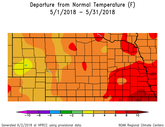
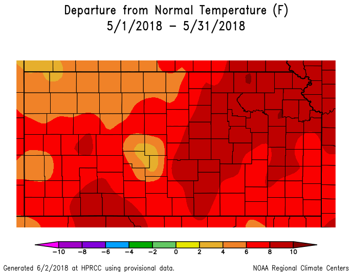
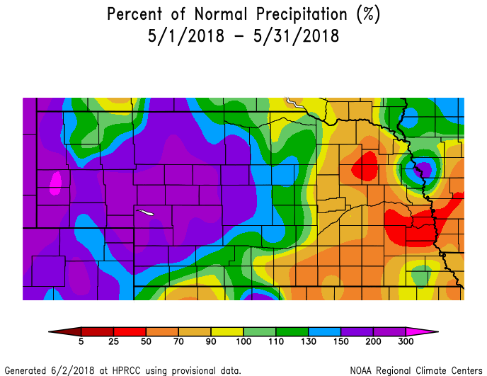
Temperature & Precipitation Departure From Normal Maps:
These images depict May 2018 monthly temperature departure from normal & precipitation percent-of-normal for both Nebraska & Kansas. Images are courtesy of the High Plains Regional Climate Center (HPRCC). Please note: These maps occasionally contain "bullseyes" of errant data. For precipitation, you can also generate departure from normal/percent-of-normal maps using the NWS AHPS page
 |
 |
 |
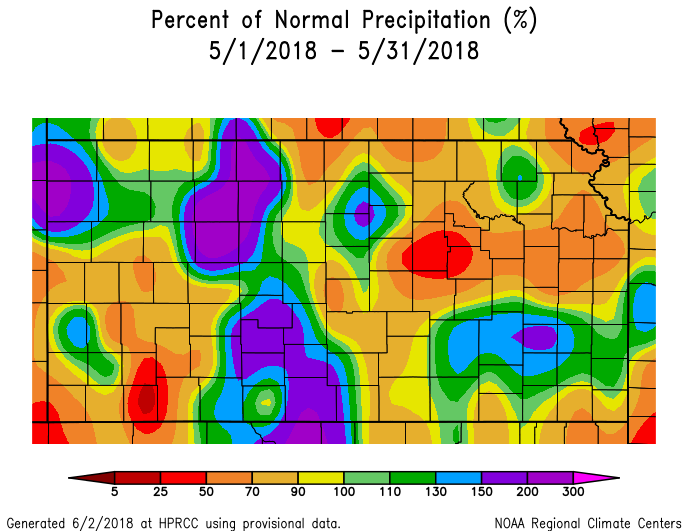 |
| Departure from Normal Temperature - NE (left) & KS (right) | Percent of Normal Precipitation - NE (left) & KS (right) | ||
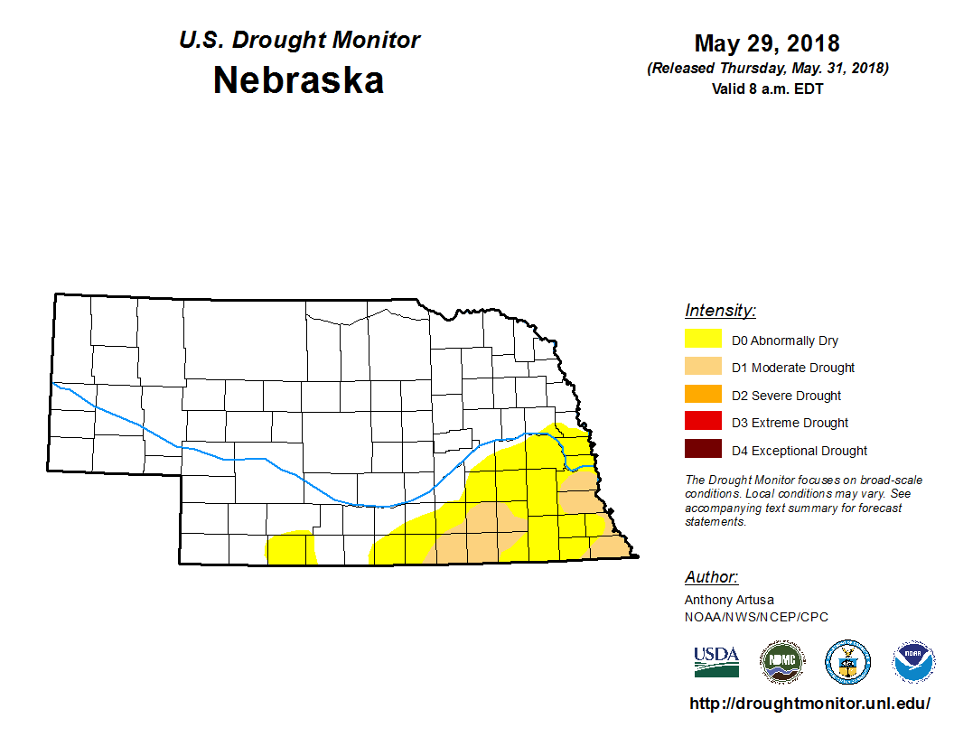
Drought:
The following drought images, current as of May 29, 2018, are courtesy of the U.S. Drought Monitor
Brief summary of changes during May across the NWS Hastings coverage area:
Given that most of the NWS Hastings coverage area observed "relatively near-normal" May precipitation, and that a few of the driest southern areas (in north central KS) saw well-above normal amounts, there was overall modest improvement in the drought situation over the course of the month. More specifically, and focusing first on the 24 local Nebraska counties, the coverage of Abnormally Dry (D0) diminished. However, on a negative note, a small swath of Moderate Drought (D1) expanded out of the Nuckolls County area to now include most of Thayer/Fillmore counties. To the south in the six local KS counties, a small reduction of both D0 and D1 occurred, with much of Phillips County actually becoming void of all drought categories whatsoever by month's end.
 |
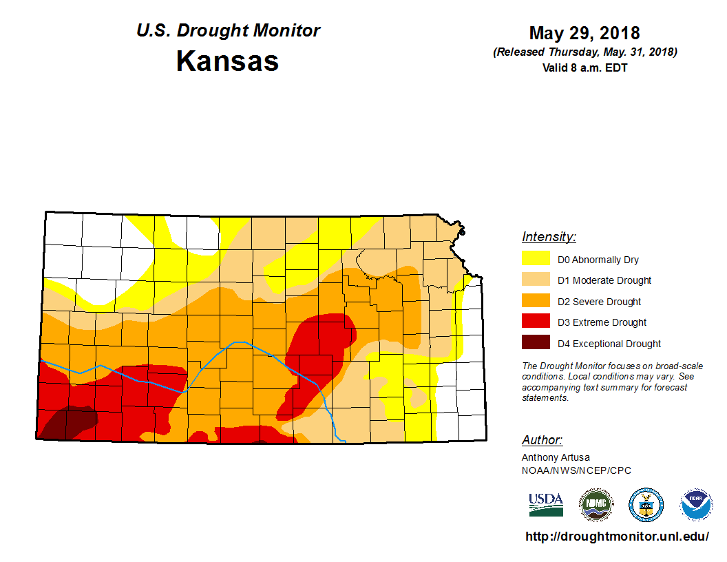 |
| Drought Monitor for Nebraska (left) & Kansas (right). Valid as of May 29, 2018 (click to enlarge) | |
Monthly Extremes for the NWS Hastings Coverage Area:
...A FEW OF THE WARMEST HIGH TEMPERATURES DURING MAY 2018...
(all data from NWS cooperative observers or automated airport sites, with the date it actually occurred indicated in parentheses)
101 degrees...Hebron airport (26th)
100 degrees...Grand Island airport (26th) - Smith Center KS (26th) - Red Cloud (26th) - Osceola (26th) - 3N York (26th)
...A FEW OF THE COOLEST LOW TEMPERATURES DURING MAY 2018...
(all data from NWS cooperative observers or automated airport sites, with the date indicated in parenthese)
37 degrees...Edison (5th)
38 degrees...Lexington airport (4th) - Gothenburg (1st) - Holdrege (5th)
39 degrees...Loup City (5th) - Beaver City (5th)
...A FEW OF THE HIGHEST MONTHLY PRECIPITATION TOTALS DURING MAY 2018...
(all data from NWS cooperative observers and CoCoRaHS/NeRAIN observers unless indicated)
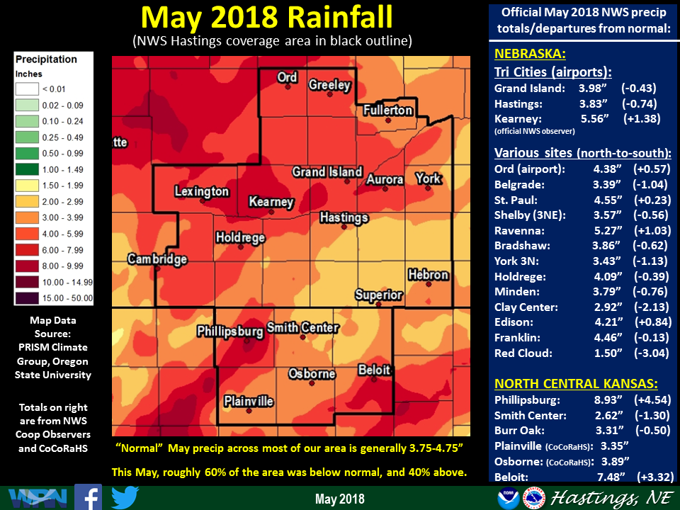
8.93"...Phillipsburg KS - 3WSW Wood River
8.62"...6W Elyria
7.48"...Beloit KS
6.98"...10WNW Stockton KS
6.82"...Riverdale
...A FEW OF THE LOWEST MONTHLY PRECIPITATION TOTALS DURING MAY 2018...
(all data from NWS cooperative observers and CoCoRaHS/NeRAIN observers unless indicated)
1.50"...Red Cloud
1.66"...6ESE Clay Center
1.78"...2WSW Tobias (east of Ohiowa)
1.79"...4S Shickley
1.93"...Harvard
 |
Media use of NWS Web News Stories is encouraged! Please acknowledge the NWS as the source of any news information accessed from this site. |
|

