Office History
February 9, 1870: President Ulysses Grant signed a law requiring the War Department to take weather observations at key marine ports, assigning this function to the Army Signal Service. The intention was to provide advanced warning of storm systems that could adversely affect marine interests. This service was the forerunner to the National Weather Service. The official name at the time was "The Division of Telegrams and Reports for the Benefit of Commerce."
October 1, 1890: President Benjamin Harrison signed an act that established The United States Weather Bureau as a civilian agency under the Department of Agriculture. Weather observations and forecast responsibility were transferred from the Army Signal Service to the Weather Bureau.
January 1, 1929: The Weather Bureau established an office at the Grand Island airport.
June 30, 1940: With the burgeoning aviation industry, the Weather Bureau was transferred from the Department of Agriculture to the Department of Commerce.
May 6, 1953: The Grand Island office was ordered to be closed by July 1st due to budget cuts.
June 11, 1953: Just 30 minutes before the weather records would have been picked up, a telegram was received stating that the office would remain open.
July 13, 1965: The Weather Bureau became part of the new Environmental Science Services Administration (ESSA) within the Department of Commerce.
1967: Internally, the ESSA began referring to the Weather Bureau as the National Weather Service. The Weather Bureau had been organized by district offices, but they were reorganized and divided into State Forecast Offices.
October 1, 1970: The ESSA was renamed to the National Oceanic and Atmospheric Administration, and the Weather Bureau changed its name to the National Weather Service. Field offices were formally designated as National Weather Service Forecast Offices (NWSFO's) and smaller satellite offices known as Weather Service Offices (WSO's). In Nebraska, Omaha was the NWSFO and was responsible for issuing the forecast for the entire state. WSO's were located in Grand Island, Lincoln, Norfolk, North Platte, Scottsbluff, and Valentine, and they were responsible for collecting and disseminating routine weather observations and issuing local warnings.
1971: A Weather Surveillance Radar (WSR-57) was installed at the Grand Island office, and it was commissioned on June 15th.
March 1972: A new office building was constructed to provide better service. Stephen Fleharty was the Meteorologist-in-Charge.
Between 1977 and 1979, major changes occurred to NWS operations with the installation of a computer system that replaced facsimile machines and teletypes for transmitting weather data and products. The computer system, known as Automation of Field Operations and Services (AFOS), displayed observed and forecast weather charts, as well as text observations and products. A typical AFOS workstation is pictured below.

Early to mid 1990s: The NWS was modernized and restructured again. NWSFO's remained but actually had reduced responsibility as they were no longer issuing forecasts for their entire respective states. Conversely, some WSO's were upgraded to full Weather Forecast Offices (WFO's) while others were closed. This was based on where the new Doppler radars (WSR-88D) would be installed to provide the best radar coverage across the United States. Some WSO's just relocated and that was the case with the Grand Island office which was relocated to Hastings. The location of the new Doppler radar was to be in Blue Hill. That location would provide the best radar coverage to the 30 counties that would become the NWS Hastings County Warning Area.
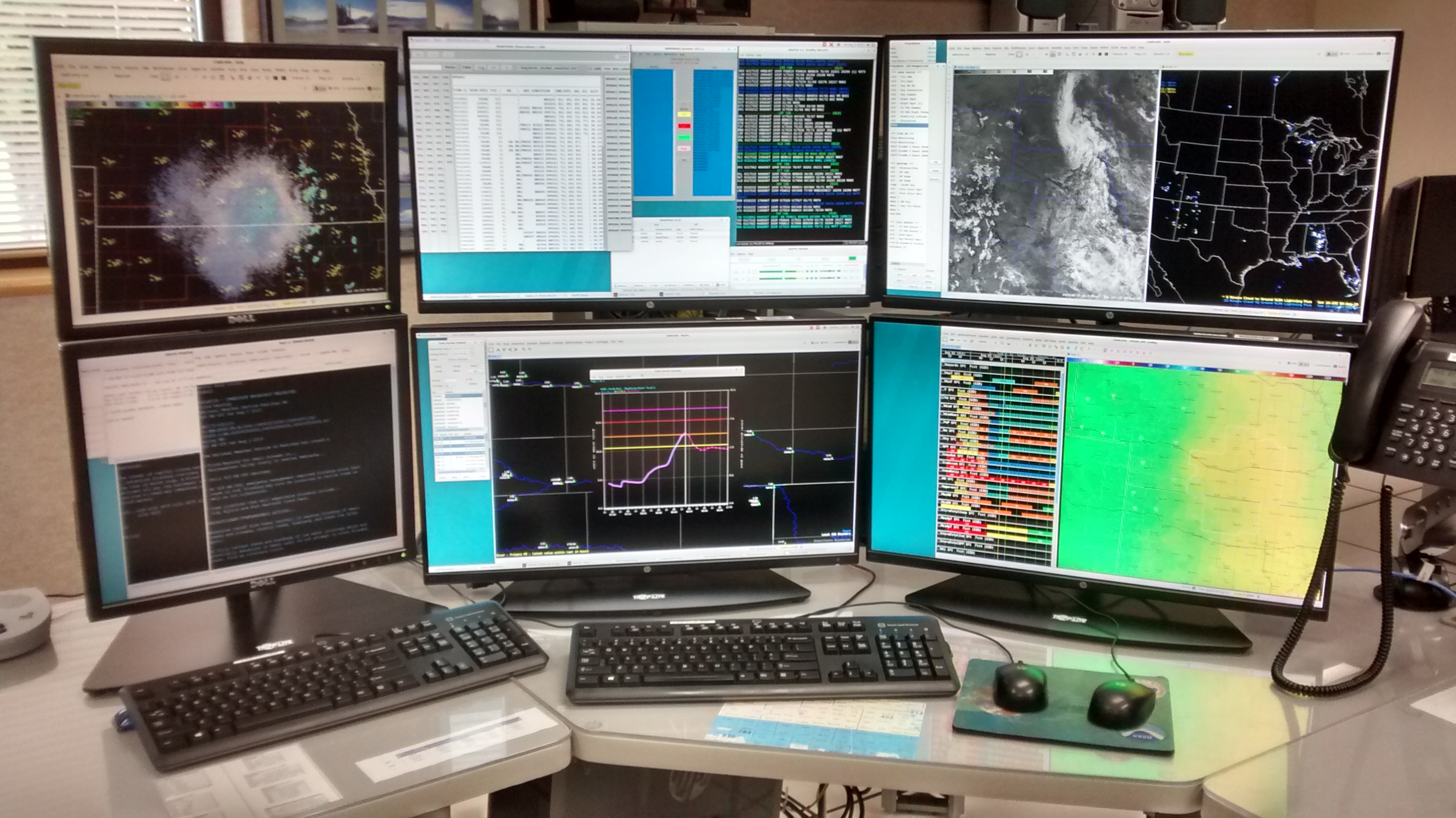
One of the tools that revolutionized how forecasters view, manipulate, and transmit weather information was the installation of the Advanced Weather Interactive Processing System (AWIPS), pictured below. This computer system allows all kinds of weather information to be displayed on one system with almost endless ways to overlay and display the data. This includes surface and upper-air observations, radar, satellite, lightning, river and lake water levels, text products, forecast models, and much more. Forecasters also use this system to monitor NOAA Weather Radio broadcasts, and create and issue forecasts and warnings. There are several of these workstations at each WFO which allows multiple forecasters to monitor the weather at the same time. The picture below shows one of the AWIPS displays in our office as of 2019.
1991: Construction of the new Hastings WFO began 4 miles north of Hastings, on Highway 281.
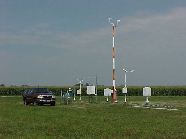
October 1, 1992: As part of the modernization, Automated Surface Observation Stations (ASOS) were installed at airports where the NWS provided climate data. These stations provide round-the-clock routine and special weather observations specifically for aviation, but also serves as the primary source of climate observations. They measure temperature, dewpoint temperature, barometric pressure, wind speed and direction, cloud coverage 12,000 ft and below, cloud height, visibility, present weather, and precipitation. The ASOS at the Central Nebraska Regional Airport was commissioned (accepted) on this date. The picture below shows an ASOS.
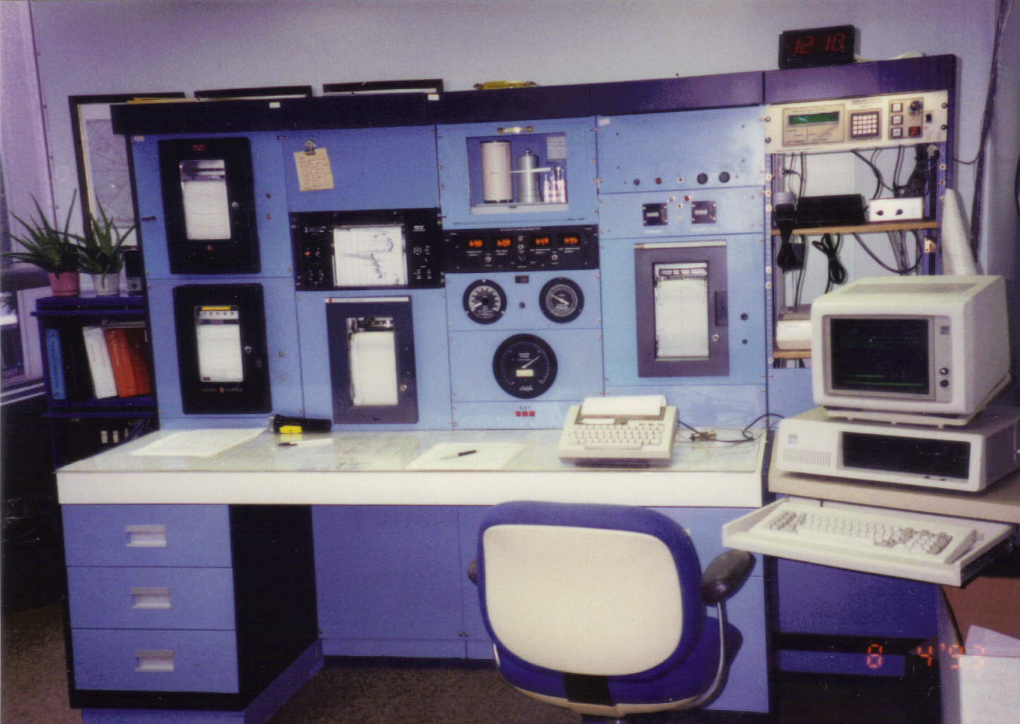
Before ASOS's were installed, humans took aviation observations. The picture below shows a typical instrument console where observations were taken and disseminated via a microcomputer.
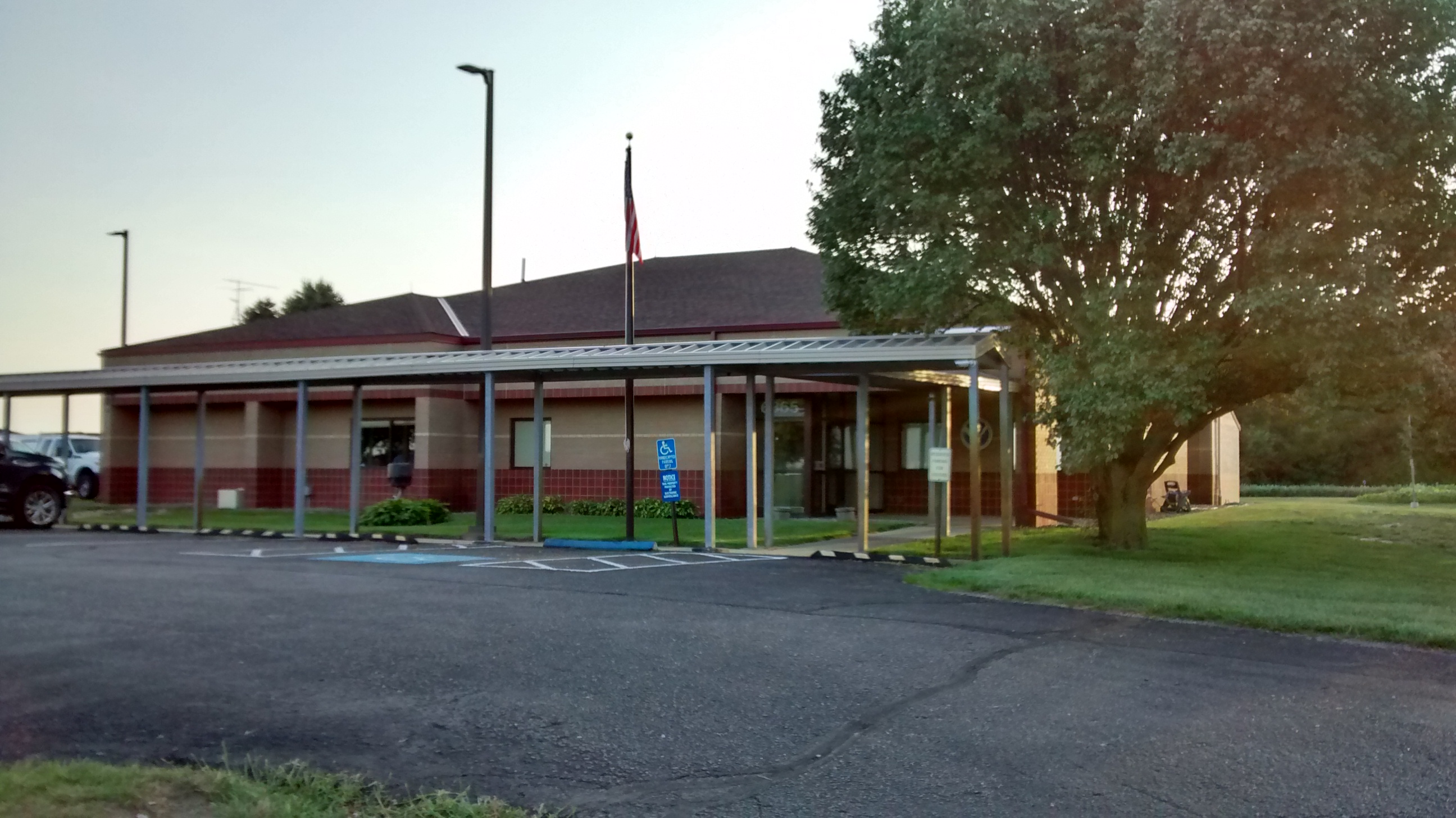
November 1992: The Hastings WFO opened and staff members were gradually added. The Grand Island WSO and Hastings WFO remained in simultaneous operations until 1995.
April 22, 1994: The Hastings WFO was dedicated with an open house. Steve Schurr was the Meteorologist-in-Charge.
January 2, 1995: The Grand Island WSO closed.
January 19, 1996: The WSR-57 radar at the Grand Island airport was decommissioned. It was torn down to make way for a new airport terminal.
March 25-April 5, 2013: The WSR-88D radar near Blue Hill was upgraded to dual polarization. So, instead of just transmitting and receiving energy in the horizontal plane, energy was transmitted and received in the vertical plane as well. This enables forecasters to better determine the size, shape, consistency, and type of targets (whether they are meteorological or not).
October 21-October 31, 2019 : The UEX WSR-88D radar underwent phase 3 of its Service Life Extension Program. The radar was down two weeks while the pedestal was replaced. The pedestal is the shaft upon which the antenna rotates and moves up and down in elevation. This required the antenna to be disassembled and the dome to be removed.
Mission
NWS Hastings serves 24 counties in south central Nebraska and 6 counties in north central Kansas (referred to as our County Warning Area - CWA), providing weather, water, and climate data, forecasts, and warnings for the protection of life and property and enhancement of the national economy.
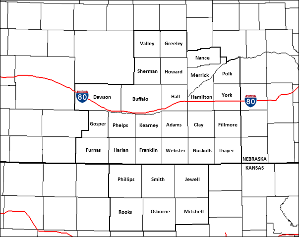
NWS Hastings collects weather observations and issues public forecasts, watches, warnings, and advisories, and other weather-related products. We issue Terminal Aerodrome Forecasts (TAFs, which are specialized aviation forecasts) for the Central Nebraska Regional Airport in Grand Island and the Kearney Regional Airport. Fire weather forecasts are issued for agencies tasked with anticipating and dealing with wildfires and prescribed burns. We provide broadcast content for six NOAA Weather Radio transmitters. Our WSR-88D Doppler radar is located in Blue Hill, NE which is 20 miles south of the office and provides continuous surveillance over the area. Our electronic technicians maintain and service the radar as well as three Automated Weather Observation Stations (ASOS), including the one at our primary long-term climate site which is at the airport in Grand Island. The others are located at Hastings and Ord.
We maintain a network of nearly 60 Cooperative weather observers who record temperature and precipitation readings each day.
The office coordinates with state and county emergency management agencies, the Nebraska Department of Natural Resources, Kansas Forest Service, U.S. Bureau of Reclamation, the U.S. Geological Survey, the Nebraska Department of Transportation, and the Grand Island Air Traffic Control Tower.
NWS Hastings is active in the community, educating via annual Skywarn Storm Spotter classes, speaking at area schools and community groups, and interacting with broadcast and print media. Several staff members are also members of local emergency planning committees.
The office also provides weather-driven and event-driven decision support service to emergency management for dozens of events such as fairs, rodeos and festivals, to ensure the safety of everyone who could be exposed to hazardous weather. The largest annual event in the forecast area is the Nebraska State Fair, which is in Grand Island. Each year, more than 350,000 people attend the fair. NWS Hastings has an exhibit each year and also provides on-site decision support in the emergency operations center for the outdoor concerts.
The office is part of the High Plains Chapter of the American Meteorological Society and National Weather Association, which includes the North Platte, Dodge City, and Goodland Weather Forecast Offices (WFO's) as well. Every four years, WFO Hastings hosts the annual conference.
There are 122 WFO's around the country as well as in Puerto Rico and Guam.The map below shows the County Warning Areas covered by each WFO.
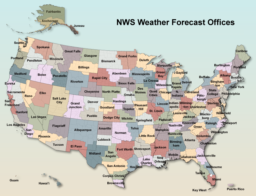
The NWS is much more than WFO's. At the highest level are "national centers" that compose the National Centers for Environmental Prediction:
The National Centers for Environmental Information collects and archives weather and climate data, and much more as well.
13 River Forecast Centers monitor water levels on creeks, rivers, and reservoirs across the nation, and they issue water level forecasts if flooding is possible or expected. The Missouri Basin River Forecast Center covers the WFO Hastings county warning area, and we work in partnership when excessive rain falls within our CWA. Water levels across the nation can be seen here. Water levels across our county warning area can be seen here. Forecasters at WFO Hastings use these data and forecasts to issue hydrologic products and flood warnings.
There are also Center Weather Service Units embedded at each of the 21 Air Route Traffic Control Center, otherwise known as "en-route centers". These are air traffic control centers. Forecasters provide briefings on thunderstorms, icing, turbulence, flight categories, and winter storms to enable controllers to safety direct aircraft across the nation.
The National Weather Service is part of the National Oceanic and Atmospheric Administration (NOAA), which is under the Department of Commerce.
NWS Hastings Staff
- Management and Support Staff
- Meteorologists (rotating shifts...24/7 coverage)
Last updated: 8/2025
Area Description
This is a land of crops, cows, and trains. All 30 counties are exclusively dedicated to agriculture. The middle third of the forecast area is dominated by fields of corn, soybeans, and hay, roughly from the Platte River Valley south to near the Kansas border. The northern and southern thirds of the forecast area are mainly range land for cattle, but cattle are regular fixtures on the landscape everywhere. Cattle/beef is a big industry here. There are many feedlots and some of them are very large. Some wheat and sorghum (milo) fields exist over the southern third as well. The busiest rail yard in the world is located in North Platte, just west of our forecast area. So there are always trains moving through. The Platte River valley is very flat, but gently rolling hills exist just a 15 to 30 minute drive to the north or south. Small gullies, resembling small canyons, develop over the southwest quarter of the area. The three largest cities are Grand Island, Kearney, and Hastings (referred to as the Tri-Cities of south central Nebraska). They are within a 25 to 60 minute drive of each other. There are approximately 300,000 people in the WFO Hastings forecast area. One-third of those people live in the Tri-Cities.
As of the 2010 census, the population of Hastings was 24,907. The population has held fairly steady since 1970. Small industry is the primary employer, with Thermo King, Dutton-Lainson, Nebraska Prime, and T-L Irrigation among the larger employers. Mary Lanning Hospital has a level III trauma center and provides a full complement of health care with 183 beds and nearly 1,000 employees. Good Samaritan Village, a large retirement community with several hundred residents, offers comprehensive care and independent living for seniors. There are 37 churches of most denominations within the city limits, and there is a modest selection of fast food and local restaurants in Hastings.
Hastings is about 25 minutes south of Grand Island, which is the largest city in the area with a population around 50,000. Grand Island features the best dining and shopping in the Tri-Cities, followed by Kearney, which is a 60-minute drive from Hastings. If you can't find something in Hastings, you can probably find it in Grand Island or Kearney.
TRANSPORTATION
There is no public transportation in Hastings. So, employees need to drive to work. Mean travel time to work is 10 minutes or less from within or near the city. Current employees live in each of the Tri-Cities. There is no school bus service in the city or in some adjacent rural areas. Amtrak service is available at Hastings twice a day (one west and one east). Grand Island's regional airport has commercial airline service with three non-stop flights to Dallas-Fort Worth each day. Direct flights are also available to Las Vegas and Phoenix multiple times each week. Commercial airline service also exists at Kearney's regional airport with twice-daily flights to and from Denver. Interstate 80 is fifteen minutes north of the office and 20 to 25 minutes north of Hastings. The office is located on Highway 281, which extends from southern Texas to northern North Dakota.
RECREATION
Recreational facilities of most types are available. There are 20 public parks and recreation facilities including Lake Hastings on the city's north edge. The YMCA is available for fitness training and includes an indoor pool. The city has two movie theaters, a symphony orchestra, and many cultural, music, and art activities sponsored by Hastings College. The Hastings Museum is a very nice facility which houses a planetarium and a theatre with a giant 65 ft wide screen capable of 3D. Hastings is home to a $6 million dollar softball complex that hosts local leagues. The Nebraska Softball Hall of Fame is co-located with the Smith Softball Complex. There are three golf courses in Hastings, one of which is PGA certified. Hastings also has a multi-million dollar water park which is a great place to cool down on hot summer days. If you like racing, Hastings Motorsports Park is a 2.15 mile road course which features racing during the warm season. The Hastings Sodbusters are an Expedition League baseball team that plays at Duncan Field from May through August.
A thoroughbred racing facility located at Fonner Park in Grand Island has live horse racing from February to May. Waterfowl, game bird, and deer hunting are available. The Platte River between Kearney and Grand Island is considered one of the best bird-watching locations in the nation. Every March and early April, hundreds of thousands of Sandhill Cranes, and even a few Whooping Cranes, congregate on and near the Platte. The area has several man-made reservoirs within a 1 or 2 hour drive. These lakes are popular locations for camping, boating, and fishing and include Harlan County Lake, Johnson Lake, and Sherman Reservoir in Nebraska; and in north-central Kansas, Kirwin, Webster, Lovewell Reservoirs, and Waconda Lake.
Many more amenities are available in Grand Island and Kearney.
EDUCATION
Hastings has a public school system with several elementary schools, one middle school, and one high school. Church-sponsored private schools are also available. Hastings College is a private liberal arts four-year school (enrollment near 1200), and Central Community College, a two-year college, offers career and technical education programs.
HOUSING
Housing in all price ranges is available in both Hastings, Grand Island, Kearney, and surrounding communities. Prices for a nice two-bedroom apartment average $500-$900 per month.
TAXES
Nebraska has an income tax, and also has a sales tax between 6.5 and 7.0%, depending on where you live. Sales tax is not collected on groceries, though. A motor vehicle tax is also assessed at the time of registration and annually, until the vehicle reaches 14 years old.
CLIMATE
The area experiences all four seasons. Summers tend to be long and winters are fairly short. Nice weather can occur from April all the way into November. Summers are very warm to hot, and they are humid, even when cooler temperatures make temporary intrusions. Summers are fairly dry with infrequent thunderstorms. Winters are moderately cold with a few minor snow events along with an occasional ferocious blizzard. This is a very sunny climate; it is difficult to get completely cloudy days. They do occur, but they are the exception. The cool season (October through March) is windy, and it can be very windy at times. Drifting snow can be extensive and impede travel during the winter, especially outside of towns and cities. There are large swings in temperatures from September through April, mainly due to intrusions Arctic air alternating with downslope-warmed air from the Rockies. Each winter usually offers a few days with a temporary taste of spring, when highs are in the 50s and 60s. The majority of the rain falls in the May and June, and tornadoes, flash flooding, and extremely large hail are an occasional threat. In May 2005, two to three inch hailstones pummeled Hastings, breaking windows and damaging the roofs and siding on hundreds of homes and buildings. July is the hottest month of the year, with daytime highs averaging 88°, but temperatures in the 90s can occur anytime between May and September. They can even occur in October. January is the coldest month with highs averaging 34° and lows around 12°. The area averages about 25 inches of snow each year, and about 26 inches of precipitation.
Disclaimer
RadarScope information and photographic imagery are used under license by Base Velocity, LLC. The map information and photographic imagery contain trade names, trademarks, service marks, logos, domain names, and other distinctive brand features. This does not imply an endorsement of RadarScope, Base Velocity, or WDTinc products or services by NOAA/National Weather Service.