|
What stands out to you as a noteworthy weather event from the past decade? We’ve posted 10 of the top events which stood out to us at the Green Bay National Weather Service. These are events which affected the 22 counties in the Green Bay NWS service area. Of course, there were many more events that impacted central and northeast Wisconsin, along with the entire state, over the past ten years. Scroll through the events, then be sure to head over to our Facebook page and *VOTE* for your most memorable event(s) and feel free to leave comments about why you chose that event. You’re welcome to *VOTE* for as many events as you like. Look for the "Top 10" album!!
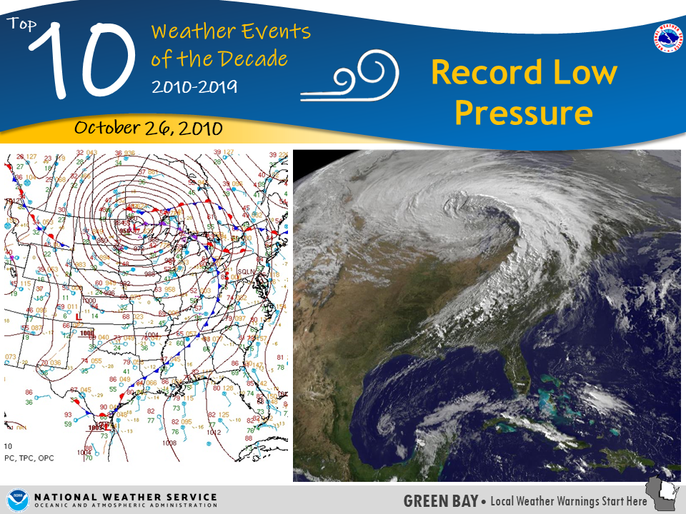
October 26, 2010 – Record Low Pressure | You may not remember this event, being it was more than nine years ago, but on October 26, 2010 an incredibly impressive low pressure system moved across the arrowhead of Minnesota creating two days of very strong winds and some of the lowest pressure values ever recorded across Wisconsin. The center of the low reached a pressure of 28.21” (955.2 mb) at Bigfork, Minnesota, a pressure that is found in a Category 3 hurricane! A pressure of 28.39” (961.3 mb) in Superior, Wisconsin set the state record. As far as northeast Wisconsin, the pressure in Green Bay dropped to 28.78” (974.6 mb), which tied for 6th lowest ever recorded. Rhinelander reached 28.62” (969.2 mb) and Wausau reached 28.65” (970.2 mb). Both of which were the second lowest pressure ever recorded at each site, and the lowest ever recorded in October. Read more.
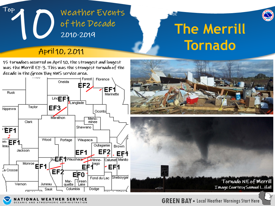
April 10, 2011 – The Merrill Tornado | Fifteen tornadoes occurred on April 10, with the most notable one impacting Merrill, Wisconsin. This was the strongest and longest tornado of the day, but also the strongest tornado of the decade in the Green Bay service area. The tornado started in far northern Marathon County and moved northeast through Lincoln County at EF-3 strength, making it the only EF-3 tornado for NWS GRB in the past ten years. Two EF-2 tornadoes also occurred this day, one in Forest County and one in Outagamie County. Read more here.
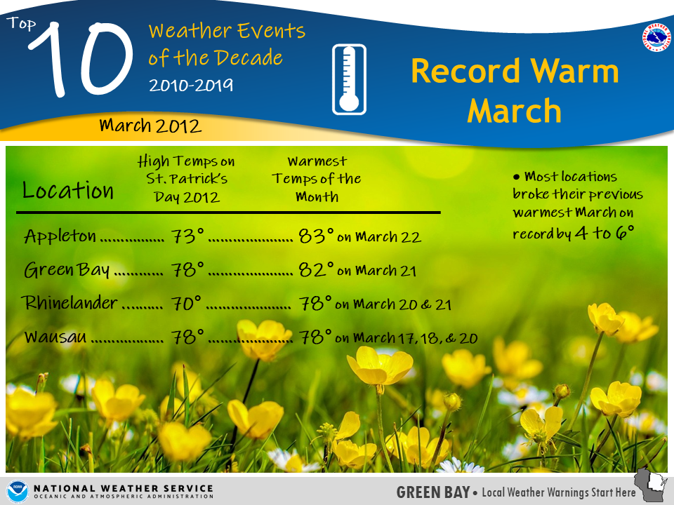
March 2012 - Record Warm March | Perhaps you remember this as the St. Patrick’s Day where you walked around in shorts. The holiday fell on a Saturday and many people pulled out their summer apparel for parades and festivities. The warmth continued for most of the month and most locations broke their previous warmest March on record by 4 to 6 degrees! For those hoping for another St. Patrick’s Day like this one, odds are you’ll be waiting a while. Read more about the warmth of March 2012 here.
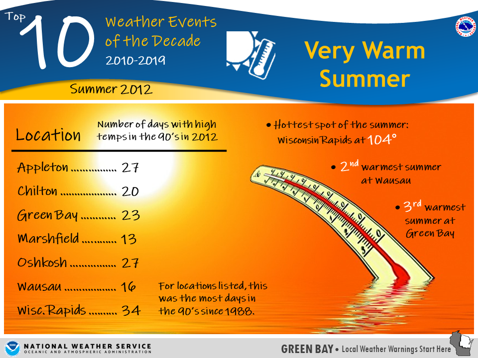
Summer 2012 - Very Warm Summer | Not long after the March warmup of 2012, summer arrived with equally impressive warmth! There were two incredible heat waves, one from late June through early July, and then another one in mid-July. It was the third warmest summer on record at Green Bay, and second warmest summer on record at Wausau. Read more here.
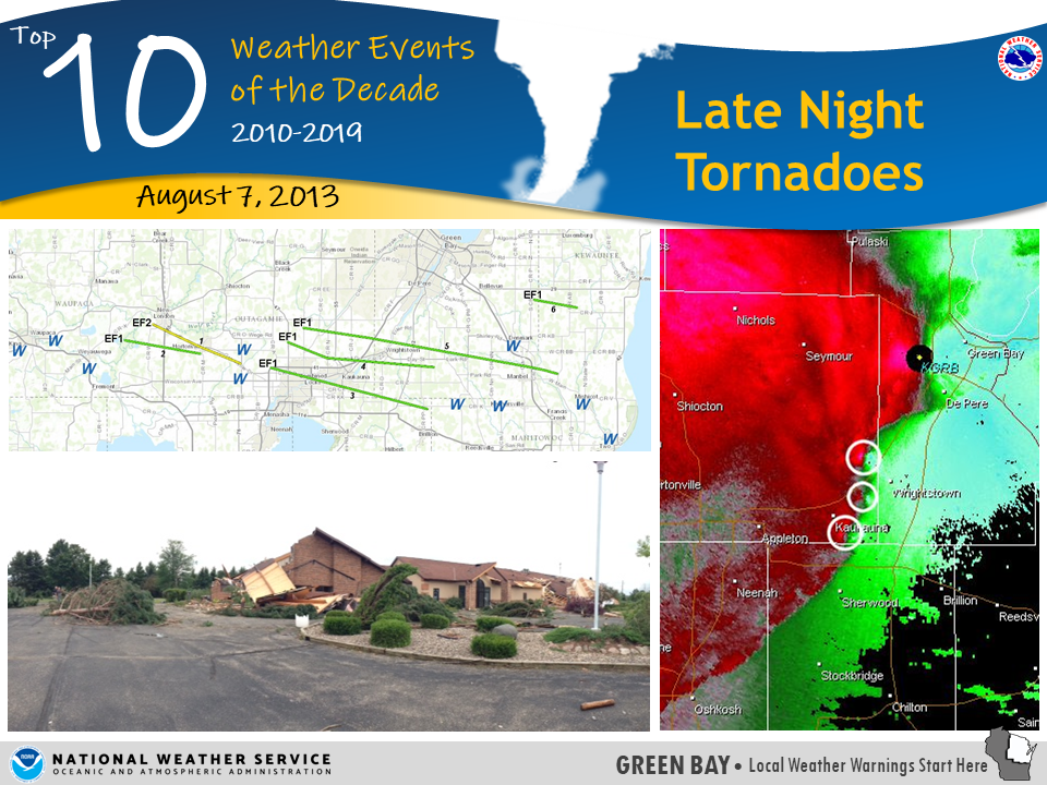
August 7, 2013 - Late Night Tornadoes | A series of tornadoes embedded within straight line winds was not an incredibly rare event in the 2010’s, but what was most significant about this event was the time it occurred, from about midnight to 1:00 am on August 7, 2013. Six tornadoes occurred within a large area of straight-line winds, all within about 45 minutes. Read the full review here.
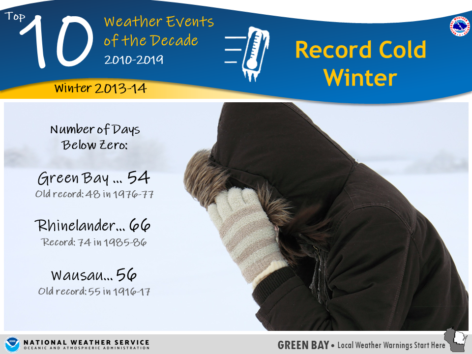
Winter 2013-14 - Very Cold Winter | The winter ‘Polar Vortex’ became a household word. What made the winter of 2013-14 most remarkable was the number of days below zero. Green Bay established a new record with 54 days below zero, breaking the old record of 48 days set during the winter of 1976-77. A new record was also established at Wausau with 56 days, breaking the old record of 55 days set in 1916-17. At Rhinelander, the total of 66 days below zero fell just short of the record of 74 days set in 1985-86. Recount some of the coldest spells here.
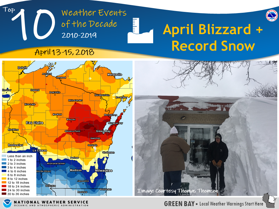
April 13-15, 2018 - April Blizzard + Record Snow | No one in northeast Wisconsin was spared from this three-day snow maker. Most places received at least a foot of snow, with a portion of central into east- central Wisconsin receiving two feet or more! This was enough to shut down in many cities, even a couple grocery stores in Green Bay closed for a period. You can read about this specific storm here. In addition to this winter storm, April 2018 in general was one of the coldest and snowiest on record. Review the month here.
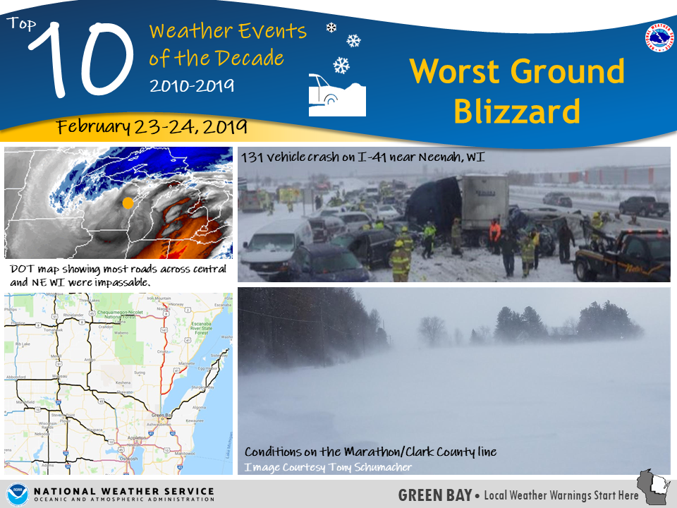
February 23-24, 2019 - Worst Ground Blizzard | Not even one year after the historic April blizzard, northeast Wisconsin got hit with another impressive blizzard. The storm impacted the entire area, but in different ways. A combination of snow, ice, and very strong winds created widespread blizzard conditions across much of central and northern Wisconsin, with many roads impassable. Across the Fox Valley only a few inches of snow fell, but the powerful winds created whiteout conditions at times. It was these conditions which contributed to the crash on I-41 near Neenah. The full event summary is here.
July 19, 2019 - Northern Wisconsin Macroburst | Wisconsin is no stranger to lines of fast moving thunderstorms with severe winds. But on the evening of July 19, 2019, the storm came together just right, creating a ‘macroburst’, or large downburst of straight-line winds, which affected a large swath from Pelican Lake in Oneida County, southeast through Langlade and Oconto counties. Hundreds of thousands of trees were snapped or uprooted, resulting in damage to dozens of homes and cottages. The damage path was about 60 miles long and up to 10 miles wide at times. Winds were at least 100 mph in the hardest hit areas near Lily in northeast Langlade County. The event summary for July 19 is here. The very next morning, on July 20, another line of thunderstorms moved across the area. These storms had a greater impact on central and east- central Wisconsin.
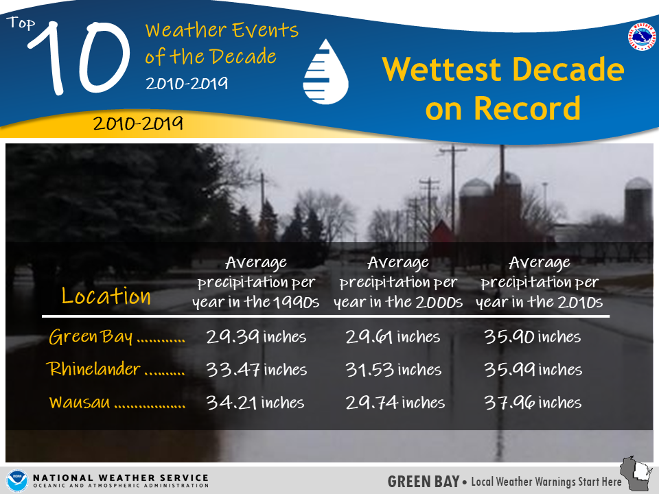
2010-2019 - Wettest Decade on Record | Finally, if you thought it seemed extra rainy or snowy over the past 10 years, you were right. The period from 2010-2019 will go down as the wettest decade on record for most sites across central and northeast Wisconsin. And 2019 alone was one of the wettest years of the decade. The extra water has contributed to several impacts, including the March 2019 river flooding and near record high Lake Michigan Water levels. More details here.
|
 |
Media use of NWS Web News Stories is encouraged! Please acknowledge the NWS as the source of any news information accessed from this site. |
|


.PNG)